
| This section is for storm chases done in the central / Midwestern United States during the year of 2008. This includes all storm chasing activities (including any major chase "expeditions") during the year of 2008 in the central USA (aka "Tornado Alley"). For 2008, all chases in the central USA will be logged in this section, with many of the chases being possible "spot" chases / major severe weather "setups" chased. Here you should find many pictures of lightning, possible tornadoes, along with many severe thunderstorm elements. Keep in mind that this chase log is scientific evidence and portrays my on-going storm chasing research. It has been placed on this page for easy reference and meteorological interests. Please do not plagiarize or copy this document to other sites for distribution. Note - This page may take a while to load on some SLOWER connections! |
STORM CHASING - CENTRAL UNITED STATES - 2008 CHASE LOGS
| CHASER NAME | HOME CITY | CALLSIGN | CHASE DATES | OCCUPATION |
| CHRIS COLLURA | MIRAMAR, FL | KG4PJN | 1-7 | IT CONSULTANT |
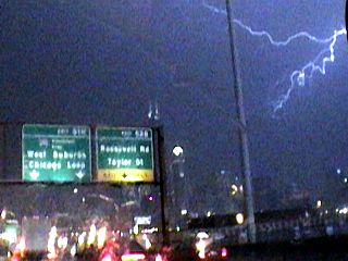
1). Jan 7, 6:00 PM - Indirect penetration of a severe thunderstorm in Cook County, Illinois to the southwest of downtown Chicago near Interstate 55. The storm was at the extreme northern portion of a line of strong and severe thunderstorms, unusual for this area at this time of the year. Conditions with this severe storm’s northern edge included heavy rains, winds near 50-MPH, small hail, and frequent lightning with some close hits. The storms were caused by a strong low pressure system, surface convergence, boundary interactions, and a strong upper-level low pressure area. Street flooding was onserved with this storm, and several direct hits of lightning to the Sear tower were also documented. A 2008 Ford Focus was used to chase the storms. Documentation was a camcorder. A tornado watch was also valid for this area until 9 PM CST.
This concludes the chase log for the chase trip on January 7, 2008. The summary includes a total of 1 severe thunderstorm. The main chase vehicle conducting this chase was a 2007 Ford Focus. This information was prepared exclusively for the National Weather service and the team of Skywarn storm spotters.
|
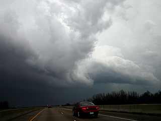
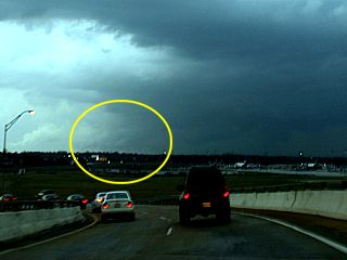
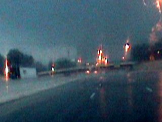
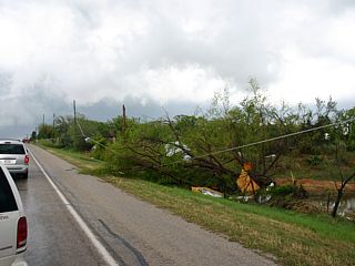
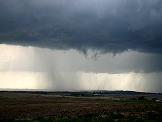
The line of severe thunderstorms moves rapidly through and south of downtown Chicago (Cook county, Illinois). This severe storm, with winds over 50-MPH and small hail, was on the northern part of a large line of thunderstorms. In this picture, I am headed north on I-55 to find a place to stop and shoot lightning, which was very frequent. |
|
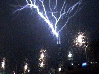
With the camera fixed on the highest point in Chicago, the top (lightning rods) of one of the Sears Tower building spires, lightning hits. Note the unique and upward branching effect. This is because the lightning polarity is positive, common with winter thunderstorms due to higher quantities of ice crystals aloft. Image is a frame from video. |
|
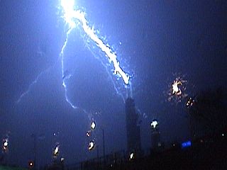
The same lightning bolt hitting the lightning rods atop the Sears Tower spires, but a second after. The main bolt becomes evident and the branching disappears. Image is a frame from video. |
|
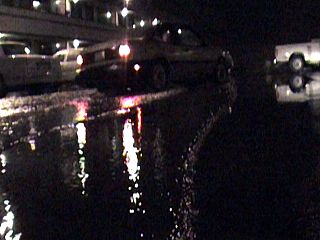
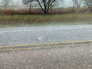
Some street flooding near Lansing, Illinois after the passeg of the squall line of strong and severe thunderstorms. |
| CHASER NAME | HOME CITY | CALLSIGN | CHASE DATES | OCCUPATION |
| CHRIS COLLURA | MIRAMAR, FL | KG4PJN | 2-4 | IT CONSULTANT |
1). Feb 4, 9:30 PM - Penetration of strong thunderstorms along Interstate 65 near Fair Oak, Indiana southward to near Morocco (highway 114) from southern Lake County into northern Newton County. The storms were a portion of a multi-cell squall line of strong thunderstorms moving across the area, rather unseasonable for this time of the year. The thunderstorms contained very heavy rains, small hail, winds gusting over 50-MPH, and frequent lightning with close hits. Extremely dense fog was associated with the thunderstorm environment, and the ground was still snow-covered from a snow storm less than 24 hours earlier! Bad visibility caused accidents, and a semi-trailer was blown into trees in the median on I-65. A warm front and upper-level trough produced the storms. The storms were elevated and ahead of a surface warm-front to the south. A strong jet-stream was also present aloft. No surface heating was noted with this setup. A 2007 Ford Focus was used to chase the storms. Documentation was a camcorder. A severe thunderstorm watch was also valid for the area until 1 AM CST.
This concludes the chase log for the chase trip on February 4, 2008. The summary includes a total of 1 strong thunderstorm. The main chase vehicle conducting this chase was a 2007 Ford Focus. This information was prepared exclusively for the National Weather service and the team of Skywarn storm spotters.
|
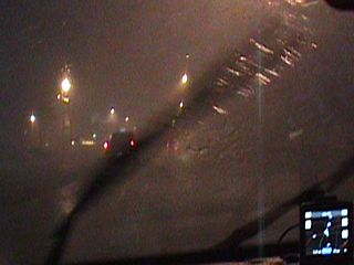
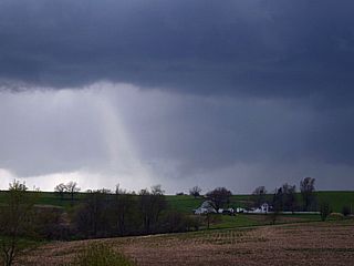
Here is a picture (frame from video) of a strong thunderstorm moving across Indiana near southern Lake county, Indiana on Interstate 65. In this picture, a cloud to ground (CG) lightning strike is to the right, but two things set this picture apart from an ordinary thunderstorm. First, the ground is covered with snow, from a snow storm that ended only 12 hours before the thunderstorm. Second is the fog, vety dense, making for an interesting effect with the lightning and snow pack. Temperatures in this elevated strong storm were only 35-40 degrees. |
|
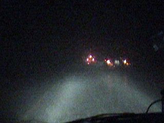
Very bad visibility in blinding rains, small hail, fog, and 50-MPH winds just north of Fair Oak in southern Lake county, Indiana on Interstate 65. |
| CHASER NAME | HOME CITY | CALLSIGN | CHASE DATES | OCCUPATION |
| CHRIS COLLURA | MIRAMAR, FL | KG4PJN | 2-5 | IT CONSULTANT |
The participants below are not from the "Sky-Chaser" chase team. These people often actively participate in my storm research and documentation efforts and deserve appreciation for their great help and severe weather expertise. Jeff Gammons and Tony Laubach below provided now-casting and updates and were of great help during this chase.
| CHASER NAME | HOME CITY | CALLSIGN | OCCUPATION |
| JEFF GAMMONS | OKEECHOBEE, FL | KG4PGA | PHOTOGRAPHER |
| TONY LAUBACH | LITTLETON, CO | KC0ONL | STUDENT |
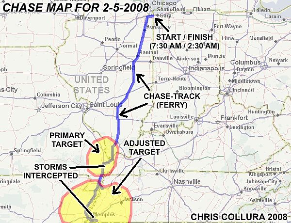
1). Feb 5, 4:30 PM - Penetration and observation of a very severe and tornadic thunderstorm on the north side of Memphis in Shelby County, Tennessee along and south of Interstate 240 and 55. The storm was an HP supercell storm developing on the southern portion of a broken line of strong and severe thunderstorms. This storm also produced a significant tornado to the northeast of Memphis and this was observed from a distance from just northwest of Memphis International Airport. Near the core of this storm, 50 MPH winds, very heavy rains, frequent lightning, and small hail was encountered. A large, blocky wall cloud was found in the rain-free base of the storm when headed south on I-240. The storms were caused by a strong low-pressure trough, both surface and aloft, slight surface heating, boundary interactions in a highly-sheared environment. A 2007 Ford Focus was used to chase the storms. Documentation was still digital photos and a camcorder. A PDS (Particularly Dangerous Situation) tornado watch was also valid for this area until 12 AM CST.
2). Feb 5, 5:30 PM - Indirect penetration and observation of a severe thunderstorm near Capleville and east of Memphis International Airport in Shelby County, Tennessee near Lamar Avenue (Highway 78). The storm was a small supercell storm that was northeast of a stronger and more intense storm to its southwest. The storm had frequent lightning and a very large rotating wall cloud. It did not produce a tornado in the immediate area. The storms were caused by a strong low-pressure trough, both surface and aloft, slight surface heating, boundary interactions in a highly-sheared environment. A 2007 Ford Focus was used to chase the storms. Documentation was still digital photos and a camcorder. A PDS (Particularly Dangerous Situation) tornado watch was also valid for this area until 12 AM CST.
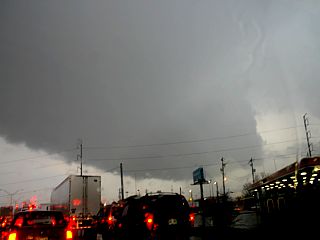
3). Feb 5, 6:30 PM - Direct penetration and observation of an extremely severe and dangerous tornadic thunderstorm near the intersection of Airways Blvd and I-240 in Shelby County, Tennessee and points south and east. This storm was a significant supercell storm that was to produce a long track and destructive tornado from southwest of Memphis International Airport then east and northeast near Germantown and eventually as far as Jackson. Observing this storm was very difficult due to visibility (because it was at dusk and in a populated area) but a brief glimpse of the tornado (a large bowl-shaped lowering on its SW side nearly to the ground) was attained. The core of the storm hit, with the tornado passing just 1/2 mile to my south, and winds (core or RFD) gusted from 70-80 MPH, frequent lightning with close hits, sideways and torrential rains, and hail 1" to isolated golfball-sized was encountered. A hasty retreat was made down Airways road south then east on Democrat road north of the airport, then SE Lamar (Highway 78). The RFD blasted to 70-MPH in rapidly clearing air and a large lowering (tornado) was visible to the east with power-flashes (very poor contrast) when making an eastward turn on Winchester road. Extensive damage to residences, a shopping mall, and numerous businesses was observed, especially where Winchester road and Hickory Hill roads meet. Debris was scattered across the street, and many powerlines / trees were down. This damage path was at least 1/2 mile wide and extended SW to NE with areas of more or lesser damage. Power was also knocked out along this path. The tornado also caused more damage and deaths during its long track to the NE at over 60-MPH. A quick radio interview report and damage survey was also conducted after this storm. The storms were caused by a strong low-pressure trough, both surface and aloft, slight surface heating, boundary interactions in a highly-sheared environment. A 2007 Ford Focus was used to chase the storms. Documentation was a camcorder. A PDS (Particularly Dangerous Situation) tornado watch was also valid for this area until 12 AM CST.
4). Feb 5, 9:00 PM - Penetration and observation of a severe thunderstorm and possible tornado observation to the southeast of Sikeston in New Madrid County, Missouri along Interstate 55 and south and along Interstate 57 and eastward through Charleston and towards Cairo, Illinois. The storm was an HP supercell storm developing ahead of a multi-cell line of strong and severe thunderstorms associated with the cold front of the approaching low-pressure area. The storm had frequent lightning with some close hits, hail to 3/4", torrential rains, and winds to 60-MPH. A large cone shaped lowering, illuminated by lightning, was noted south of this storm cell before encountering precipitation when about 5 miles south of Sikeston on I-55 (looking NNE). The storms were caused by a strong low-pressure trough, both surface and aloft, and approaching cold front in a highly-sheared environment. A 2007 Ford Focus was used to chase the storms. Documentation was a camcorder. A PDS (Particularly Dangerous Situation) tornado watch was also valid for this area until 12 AM CST.
This concludes the chase log for the chase trip on February 5, 2008. The summary includes a total of 4 severe thunderstorms with 3 possible tornadoes, two of which are confirmed, and one of which was a killer tornado. The main chase vehicle conducting all chases was a 2007 Ford Focus. This information was prepared exclusively for the National Weather service and the team of Skywarn storm spotters.
|
The long drive south to the target area along Interstate 57 was mainly in 35-40 degree temperatures with fog and drizzle. In the extreme southern tip of Illinois, and crossing into Missouri, the warm sector was encountered. Looking south in this picture, the NE to SW oriented frontal boundary, with partly sunny skies to the south can be seen. A temperature increase from 40 degrees F to 70 degrees F also existed heading south across this boundary. |
|
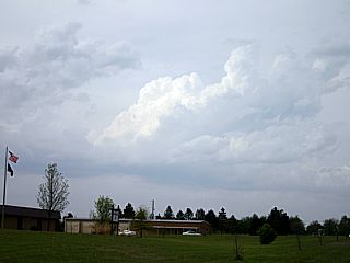
This picture shows a small and highly-sheared towering cumulus trying to develop southeast of Hayti, Missouri. This was on the northern portion of another differential heating boundary that was in place from here southward, and was to be a key player in storm development later. The tower goes up, but does not last long as the shear quickly topples it over. |
|
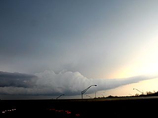
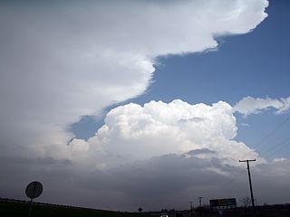
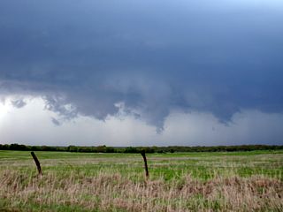
Headed south on I-55 from Missouri into Arkansas, a multi-cell line of strong and severe thunderstorms rapidly develops along a differential boundary / confluence axis nearly parallel to the Mississippi river to the east. The target is not these storms, but the southern portion of this storm complex. Note the mesocyclone denoted by the slight banding in the mid-levels of the updraft column, flared out base, and weak RFD "notch" in the large cumulonimbus from the center of the picture and to the left. |
|
The southern end of this line of sever thunderstorms develops a tail-end "Charley" type supercell. This large storm was one of the first to develop north and west of the Memphis, Tennessee area. The view is to the south from a distance of about 30 miles. |
|
Interesting cloud formations in the back-side of the first developing HP supercell to the north of Memphis, Tennessee. The game plan is to take I-40 and divert to the north of the storm's updraft and then south to view the updraft base. |
|
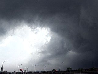
Here is a view of a large, rotating wall cloud just northeast of downtown Memphis, Tennessee. This storm was rapidly intensifying and was to produce one of the first tornadoes in the area. The view is to the south towards the "bear's cage" of the storm on I-55 / I-240. |
|
Here is a view of one of the first supercell storms from an overpass just northwest of Memphis International Airport looking northward. The RFD clear slot is evident and "lowerings" (tornado) on the ground behind it just to the left of the darker precipitation core. This picture was taken just when a large multi-vortex tornado was ocurring just NE of Memphis, TN. |
|
A large wall cloud passes just south of Memphis International Airport near Lamar Avenue (Highway 78) and just north of Capleville in Shelby County, TN. This storm was a supercell storm which did not produce a tornado, but was part of the supercell outbreak across the area. |
|
Interesting inflow tail (aka "Beavers Tail") extending from the south to the north (view is to the east from an overpass along I-240) into a supercell storm (the same one that produced the rotating wall cloud in the previous picture above). |
|
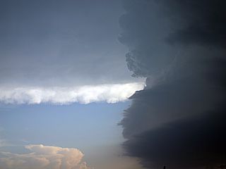
This is a view of the anvil blowoff (top-right), updraft tower (center), and flanking-line (lower left) of the to-be devastating supercell storm that would cause death and destruction south and east of Memphis. The view is from an intersection south of I-240 and Highway 78 (Lamar Avenue). Keep in mind that this chase was near dusk, in a populated area, and during rush hour. Note the clear-cut anvil edge to the upper-left. |
|
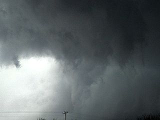
Looking west at the tornadic supercell's updraft base from near I-240 and Airways Blvd, a large lowering (wall cloud / developing tornado) can be seen to the west and southwest (center of the picture). This is the only glimpse of the approaching disaster because of horrible urban terrain and poor-lighting / contrast at dusk. The storm core is to the right, and coming right at me. |
|
The southern core of the supercell passes over as I quickly make a hasty retreat to blast back east and get ahead of the storm. I am between the tornado, now tearing across then southeast of the Memphis International Airport 1/2 mile to my south, and HP supercell core (with hail to baseball sized) to my north. Winds are from the north and gusting 70-80 MPH with hail 1" to golfball sized. Unfortunately, there was no way to get ahead of a storm moving east and northeast at over 65-MPH. |
|
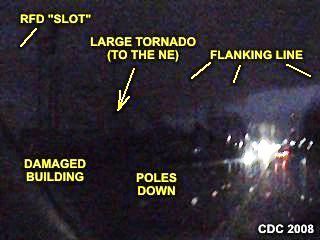
Here is an annotaged image taken just minutes after the tornado passed over the Winchester / Hickory Hill areas southeast of Memphis. The view is to the east and northeast and the contrast is absolutely horrible, so I'll have to describe what is being looked at. Power is knocked out, and a damaged building can barely be seen to the lower left, with power poles dowm. The updraft base / flanking line of the rapidly departing supercell can be seen to the right. From the center to the left, the large lowering is a portion of the large tornado moving off to the northeast. The lighter shades from the upper-left is dusk twilight trickling through the RFD "clear slot" behind the supercell core. |
|
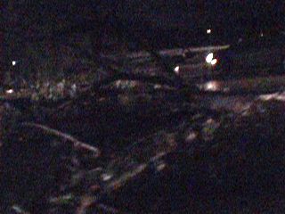
With power out and a long SW to NE oriented damage path, many roads became strewn with both power poles, tree debris, and damaged building debris. This is near the Winchester mall, where people were trapped under a collapsed roof. |
|
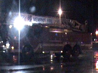
Many emergency / fire rescue vehicles flood the Memphis streets and points east as search and rescue begins after the tornadoes. As darkness falls, tornadoes continue to the east causing more deaths and destruction into central Tennessee. Daylight on February 6 (the next day) was to reveal the true horror of this outbreak. |
| CHASER NAME | HOME CITY | CALLSIGN | CHASE DATES | OCCUPATION |
| CHRIS COLLURA | MIRAMAR, FL | KG4PJN | 3-15 | IT CONSULTANT |
| TONY I | SUNNYVALE, CA | ??? | 3-15 | CONTRACTOR |
1). Mar 15, 4:30 PM - Observation and penetration of a strong thunderstorm, and attendant funnel cloud, along Highway 4 in Contra Costa County, California. The storm was a cold-core thunderstorm developing in a cool Pacific air mass under a region of very cold air aloft. Small hail (pea sized), 30+ MPH winds, and heavy rains were encountered with this small storm. A brief funnel was noted on the northwestern side of the storm during peak intensity to the northeast of Concord, California. The funnel did not touch down. Conditions causing the storms were modest surface heating, a strong low-pressure area aloft (steep lapse rates), and boundary / orographic interactions. A 2007 Dodge Calibre (rental) was used to observe the storms. Documentation was digital stills and digital video.
This concludes the observations log for the storms in central California on March 15, 2008. The summary includes a total of 1 strong thunderstorm and 1 funnel cloud. The main chase vehicle conducting this chase was a 2007 Dodge Calibre (rental). This information was prepared exclusively for the National Weather service and the team of Skywarn storm spotters.
|
This is a storm south of Highway 4 in Contra Costa County, California with some rather interesting storm structure (slight rotation). A hail shaft is clearly visible to the left in this picture. Note the interesting updraft base to the right on the northwest side of the storm. Motion was to the southeast and the view here is to the SSW. The foot hills of Mount Diablo can be seen east of Concord in the background. |
|
A small funnel cloud develops on the updraft side of the small storm northeast of Concord, California as we look west along Highway 4. The funnel lasted about a minute and did not touch down. |
|
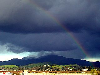
Looking east from Concord, California, the storm moves to the southeast and over the mountains and into the central valley. Mount Diablo, over 4,500 feet high, is the large mountain grazing the storm's high base, and is probably receiving wet snow and hail from the storm. The afternoon sun angle allows good contrast and a rainbow. |
|
This is a picture of the small hail (pea sized) hitting ther windshield while passing one of many intense cold-core storms. The hail was very soft, almost like baby snowballs. The low freezing level (less than 850 MB) and steep lapse rates allowed the storms to produce hail like this. |
| CHASER NAME | HOME CITY | CALLSIGN | CHASE DATES | OCCUPATION |
| CHRIS COLLURA | MIRAMAR, FL | KG4PJN | 3-31 | IT CONSULTANT |
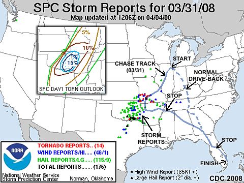
1). Mar 31, 4:30 PM - Penetration of very severe (or possibly tornadic) thunderstorms to the northeast of Springfield, Missouri along Interstate 44 in Webster County. The storms were a portion of a multicell cluster / line of strong and severe thunderstorms. The cell penetrated was an HP supercell / bow segment within the line of storms that contained wind gusts near 70-MPH and hail up to dime-sized. Torrential rains and frequent lightning was also noted with this storm. Debris was observed across Interstate 44 along with trees / poles down and a roof ripped off a building. This storm was the same storm that caused tornado-like damage to the north of Springfield. The actual tornado was not observed, but a cyclonic motion was noted with the storm. The storm was caused by a low pressure system and strong upper-level disturbance. Documentation was digital video and stills. A 2007 Ford Focus was used to chase the storms. A tornado watch also was in effect for the area until 9 PM CDT.
2). Mar 31, 6:30 PM - Penetration another severe thunderstorm in Van Buren County, Arkansas near Clinton along Highway 65. The severe storm was part of a multicell line of strong and severe thunderstorms. Heavy rains, frequent lightning, small hail, and winds gusting over 60-MPH were observed with this storm. The storm was caused by a low pressure system and strong upper-level disturbance. A 2007 Ford Focus was used to chase the storms. A tornado watch also was in effect for the area until 9 PM CDT.
This concludes the observations log for the storms in Missouri and Arkansas on March 31, 2008. The summary includes a total of 2 severe thunderstormS (one of which was most likely the cause of tornado damage near Springfield, Missouri). The main chase vehicle conducting this chase was a 2007 Ford Focus. This information was prepared exclusively for the National Weather service and the team of Skywarn storm spotters.
|
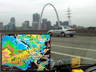
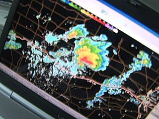
Passing through Saint Louis and into Missouri from Illinois just after 1 PM and crossing the Mississippi river via I-55 (connects to I-44). This chase was also fantastic chance to test and validate two great new additions to my storm chasing "toolbox". I was able to get AT&T wireless mobile broadband vie their new 3G (Sierra) USB card and sign up with Swift WX for data. These two worked very well together and cell / data signal was seldom lost, even in very remote areas of the Ozark Mountains. In this picture, we can see the squall line as well as the SCIT displays (Storm Cell ID and Tracking) denoting hail and / or storm rotation. Swift WX also allows location tracking (other chasers can be seen) as well as GPS interfacing showing your location, the storm, and roads all in one integrated package! |
|
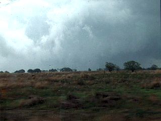
Interesting convective rolls (light and dark bands) in the low-level stratocumulus deck denote extreme wind shear ahead of the storm cluster / line in central Missouri. Unfortunately, lack of sunshine (sufficient diurnal heating) kept instability modest. |
|
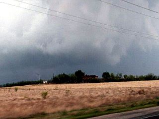
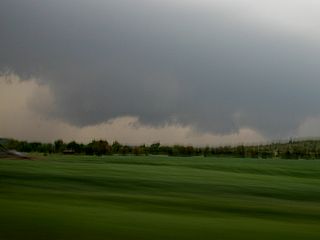
Here is a view of the gust front of the severe storm near Springfield, Missouri. This storm had a possible tornado as well as a history of producing wind damage. Winds at this time were gusting near 70-MPH. |
|
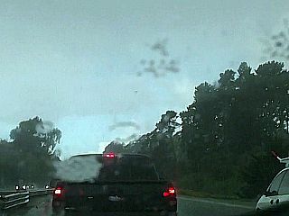
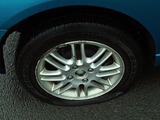
One of those chasing "moments" ... Flat tire from a piece of metal in the roadway north of Clinton, Arkansas along highway 65. This did not stop the chase, as I was able to put on the spare and have the tire replaced the following day. |
| CHASER NAME | HOME CITY | CALLSIGN | CHASE DATES | OCCUPATION |
| CHRIS COLLURA | MIRAMAR, FL | KG4PJN | 4-8 TO 4-11 | IT CONSULTANT |
The participants below are not from the "Sky-Chaser" chase team. These people often actively participate in my storm research and documentation efforts and deserve appreciation for their great help and severe weather expertise.
| CHASER NAME | HOME CITY | CALLSIGN | OCCUPATION |
| TIM SAMARAS | DENVER, CO | N/A | SCIENTIST / ENGINEER |
| TONY LAUBACH | LITTLETON, CO | KC0ONL | STUDENT |
| VERNE CARSON | DENVER, CO | KB0ZCQ | IT |
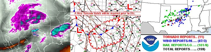
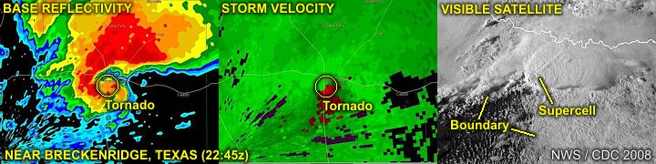
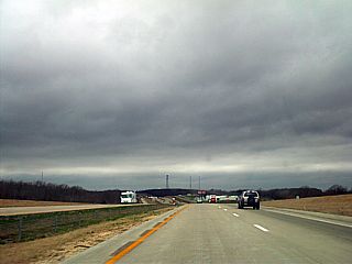
1). April 9, 5:30 PM - Interception and observation of an extremely severe and tornadic thunderstorm near Breckenridge, Texas and near Highway 183 and 180 in Stephens County, Texas. The storm was a violent supercell thunderstorm that had a very long track, initiating near Nolan, Texas (near Highway 277 south of Sweetwater) and tracking well to the east and northeast before finally weakening near Collinsville (at least 6 hours later and over 200 miles to the NE of its point of initiation)! The storm was the most intense for a short time as it tracked from near Tye, Texas to points past Breckenridge. This storm produced at least 3 tornadoes during this early stage in its life, and as it was in classic supercell mode (after that it weakened and evolved to HP). 3 tornadoes were observed, including the end-stage of the destructive second tornado that affected Breckenridge. Torrential rains, winds gusting well over 70-MPH, frequent lightning, and golfball-sized hail (or larger) was also encountered with this storm. Damage observed was in Breckenridge, and included an overturned semi-truck, power poles snapped, trees uprooted, and buildings / houses destroyed (or having their roofs torn off). Luckily, no one was hurt in Breckenridge, but I did stop to help out / clear debris. The storm was caused by a warm / stationary front, boundary / dryline interactions, surface heating, intense wind shear, and a strong low pressure system / trough. Documentation was still digital pictures and HD video. A PDS (Particularly Dangerous Situation) tornado watch was also valid for the affected area until 8 PM CDT. A 2008 Kia (rental) was used to chase the storms.
2). April 10, 4:30 PM - Observation of a small but possibly severe thunderstorm in Desha County, Arkansas near Highway 165 and to the northeast of Dumas. This was a small storm that developed along a shear-axis (boundary) and produced some brief funnels on its updraft base. The core of this cell was not intercepted and no damage was observed, except for severe river flooding (from many other storms earlier that day in a squall line) which inundated some homes and farms in the area. The storm was caused by boundary interactions, surface heating, wind shear, and a strong low pressure system / trough. Documentation was still digital pictures and HD video. A tornado watch was also valid for the affected area until 11 PM CDT. A 2008 Kia (rental) was used to chase the storms.
This concludes the Chase Log for the Texas, Oklahoma, and Arkansas area from April 8 through April 11, 2008. The summary includes a total of 2 severe thunderstorms, one of which produced at least 3 tornadoes. A total of 3 tornadoes were observed with one of the storms, all confirmed. The main chase vehicle conducting all chases was a 2008 Kia (Rental). This information was prepared exclusively for the National Weather service and the team of Skywarn storm spotters.
|
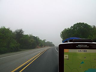
Here is a view headed souhwest towards the target area of Abilene, Texas along highway 180. The weather here is cloudy and foggy, with rain and cool drizzle because I am still north of the warm-front boundary, which is still near Interstate 20 and 40-50 miles away. |
|
One of the first storms to initiate along and south the warm-front boundary near Sweetwater and Abilene. This storm, in the center of the picture, will eventually be the long track (and destructive) supercell of the day. The anvil to the upper left is from a weakening and elevated storm north of the warm-front to our west. The view is ENE. |

|
Tim Samaras and Tony Laubach watch a developing supercell near Tye, Texas off I-20 after clearing a tumble-week that was stuck under the front of his van. |
|
Impressive RFD clear slot develops (left side of picture) and funnel cloud can be seen to the right as the supercell storm intensifies near Tye, Texas. The view is to the northwest. |
|
Rapidly rotating wall cloud and possible tornado (tornado #1) near highway 707 and noth of Tye, Texas. The funnel / tornado is between the center and right side of the picture. Other storm chasers reported a dust swirl associated with this feature confirming a tornado (the dust is not visible in this picture). The view is to the northwest. |
|
Intense RFD clear slot and funnel associated with the same developing supercell near highway 707. This is still possibly on the ground. The view is to the west. |
|
Golfball-sized hail pounds highway 707 as a smaller mesocyclone to the south of the Tye supercell storm merges with it and the intense precipitation core passes overhead. |
|
While blasting north on Highway 183 out of Cisco, this incredible supercell storm (with the classic "flying eagle" radar image) bears down on the unfortunate town of Breckenridge, Texas. Shear values of almost 200 knots showing nicely via the Dyess AFB radar site! Radar and tracking (using GPS) provided by SwiftWX software and data service provided by AT&T's Sierra 3G mobile broadband USB package. |
|
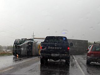
Semi-truck overturned on highway 183 just south of Breckenridge, Texas. The driver was not hurt. This was part of a large damage path which contained power poles and trees snapped, as well as some buildings severely damaged or destroyed. |
|
This is a view, looking NE along the damage path at a possible tornado (and possibly a second tornado that struck Breckenridge and points east). The tornado is just above the foreground and in the center of the picture. Other chasers east of Breckenridge were reporting a large and dusty tornado at this time, looking in the opposite direction. Intense RFD and clear "slot" can be seen to the left. |
|
Some more damage on the eastern side of Breckenridge, texas near highway 180 and 67. Some homes and buildings were severely damaged or destroyed, and power poles were snapped. The view here is to the east (not the backside of the new mesocyclone to the right-center of this cyclic supercell). |
|
In this picture, caught by accident, the un-mistakable rope stage of the first Breckenridge tornado can be seen in the center of this picture (from a video surveying the damage near highways 180 and 67). Some airborne dust and debris, just above the man walking, and left of the tornado, can also be seen. This is the old mesocyclone of the supercell, with the new mesocyclone resulting in the new tornado to the east of town (shown earlier in one of the pictures above). The view is NNE. |
|
A small funnel develops on the rain-free base of this small severe storm in eastern Arkansas (northeast of Dumas). Despite high severe weather expectations, the "ingredients" for a severe weather outbreak did not "phase up" as expected. |
|
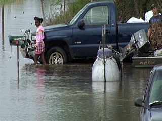
Severe flooding was the biggst impact in this area, near Marvell and Aubrey, Arkansas. This home is severely flooded by rising river waters as helpless residents wade through the flood. |
|
Flooded trailer park / camp ground near Aubrey, Arkansas. |
|
Interesting cloud formations east of Little Rock, Arkansas and along I-40. The lack of "phasing", where the surface features and upper-level features "line-up" for a severe weather outbreak, caused less than expected severe weather this day. Well behind the surface boundary and instability axis, the area of upper-level vorticity (DVA and upper-lift) makes its mark with elevated showers and clouds denoting extreme turbulence aloft. The clouds take on a "mammatus" like appearance because of the turbulence. |
|
The mid-level dry air slot of the now large storm system to the northwest over the central USA is preceded by a dryline / Pacific front. The clouds and moisture appear to suddenly stop near the leading edge of this boundary (dry-punch). The view is to the west. |
|
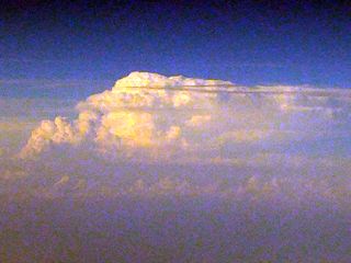
This picture was taken after departing Houston, Texas on a Boeing 737 at an altitude of about 20,000 feet on April 8 at about 6:15 PM CDT while en-route to Dallas. The view is to the south and southeast, and bands of clouds called horizontal convective rolls (HCR's) can be seen far below in the boundary layer. These clouds are caused by rising air in a moist boundary layer that is capped with stronger winds, often from a different (usually veered) direction aloft. The cloud bands develop along rising air while the "spaces" between them are sinking air, and align parallel to the low-level winds, forming a horizontal "aspect roll" (vortex couplet). These cloud formations are often found in environments where moisture and directional wind shear (horizontal rotation) prevades the low-levels of the atmosphere. |
|
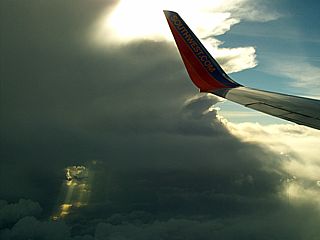
This picture was taken during the arrival into Dallas, Texas after connecting through Houston on a Boeing 737 at an altitude of about 25,000 feet on April 8 at about 6:40 PM CDT. The plane actually descended to get under the anvil of the storms, and turbulence was moderate for a short time. This was most likely the frontal genesis of the warm front boundary that was to be such a big issue for producing tornadoes on April 9. The storms here are severe, and eventually produced two tornadoes about 50 miles south of the Dallas-Fort Worth area. Note the "split" developing between the two storms to the lower left, in a DOWNWARD looking point of view! |
|
This picture was taken from a Boeing 737 leaving a Houston, Texas connection to Fort Lauderdale, Florida on the afternoon of April 11 (roughly 6 PM EDT) at about 39,000 feet over the Gulf of Mexico and well off the Louisiana / Mississippi coastline. Looking to the NNW, the un-mistakable view of a supercell storm looms over the horizon. Based on SPC's storm reports, this storm was responsible for a tornado, violent winds (over 80-MPH), and hail at least baseball sized (2.75") in Louisiana and Mississippi. |
| CHASER NAME | HOME CITY | CALLSIGN | CHASE DATES | OCCUPATION |
| CHRIS COLLURA | MIRAMAR, FL | KG4PJN | 4-29 TO 5-5 | IT CONSULTANT |
1). May 1, 8:00 PM - Interception and observation of an extremely severe and tornadic thunderstorm from near Howard / Moline, Kansas and points northeast through Chanute in Wilson County. The storm was followed from its point of initiation at about 6 PM to past Allen County at about 10 PM. The storm also produced a multi-vortex tornado, inwhich at least one suction vortex was observed on the ground with debris near the intersection of Highway 75 and Highway 39. The storm was a supercell thunderstorm, and evolved between classic and HP (high precipitation) modes. Numerous funnel clouds / possible additional brief tornadoes were also observed with this storm. The storm also produced frequent lightning, torrential rains, winds to 65-MPH, and hail up to tennis-ball sized (2.25"). No damage was observed as most tornadoes, hail, and winds occurred over rural areas of Wilson and Allen counties. The storm was caused by boundary / dryline interactions, surface heating, intense wind shear, and a strong low pressure system / trough. Documentation was still digital pictures and HD video. A tornado watch was also valid for the affected area until 1 AM CDT. A 2008 Dodge Calibre (rental) was used to chase the storms.
2). May 2, 12:00 AM - Observation of a severe thunderstorm near I-35 at the Days Inn motel in Franklin county in Ottawa, Kansas. The storm was a bowed-out line segment of severe thunderstorms, and produced winds gusting over 70-MPH. Frequent lightning, torrential rains, and pea to dime-sized hail was also observed with this storm. The storm caused some wind damage and knocked out power in some areas. The storm was caused by a strong cold front, upper trough (wind shear), and a strong low pressure system. Documentation was HD video. A tornado watch was also valid for the affected area until 1 AM CDT. A 2008 Dodge Calibre (rental) was used to chase the storms.
3). May 2, 6:00 PM - Observation and penetration of a strong to severe thunderstorm near Gratiot, Wisconsin and highway 78 in Lafayette County. The storm was a multicell storm but briefly acquired supercell characteristics before evolving to a line-segment. The storm produced small hail, very heavy rains, frequent lightning, and winds gusting near 55-MPH. A wall cloud and RFD (rear flank downdraft) was also noted on this storm before weakening. The storm was caused by an occluding cold and warm front, cold-core low pressure system, surface heating, and upper-level low (differential vorticity / cold air aloft). Documentation was still digital pictures and HD video. A tornado watch was also valid for the affected area until 10 PM CDT. A 2008 Dodge Calibre (rental) was used to chase the storms.
This concludes the Chase Log for the May 1 through May 2, 2008 in Kansas, Illinois, and Wisconsin. The summary includes a total of 3 severe thunderstorms, one of which produced at least 1 tornado. A total of at least 1 tornado were observed with one of the storms, one confirmed. The main chase vehicle conducting all chases was a 2008 Dodge Calibre (Rental). This information was prepared exclusively for the National Weather service and the team of Skywarn storm spotters.
|
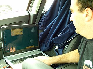
Here is a picture of myself, working my laptop and equipment. I am connecting to the internet (via wireless 3G) to check data and forecasting products while waiting in the first target area of Chanute, Kansas. |
|
Looking at the dryline from Howard, Kansas, which is moving in from the west, a line of cumulus develops along it. In this picture, the dryline boundary stretches from left to right along the lower portion of the picture. The highly-sheared towering cumulus (center) will reach the LFC (level of free convection) above the cap and explosively develop into a supercell (this one did so in LESS than 10 minutes). The view is to the WNW from the "moist" side of the dryline. |
|
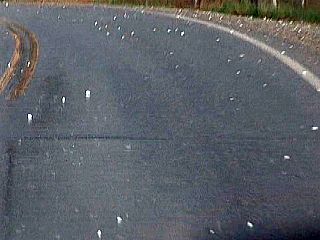
This is a picture of the roadway, near Fredonia in Warren County, Kansas, after the supercell core passed overhead. The hail stones laying in the road and on the ground were as big as tennis balls (about 2.25 inches). |
|
The Warren County storm gets more organized, and a wall cloud forms, with these small funnels. |
|
Here is a view looking SSW and upwards at the Warren County supercell main updraft. A sheer, striated vertical wall to the right denotes powerful, rotating updraft. The striated pattern is sometimes called a "barber pole" updraft. Speeds in this updraft can exceed 150-MPH. Note the impressive anvil towards the top of the picture. The distant supercell (lower left) in the picture is over Oklahoma and also produced a tornado. |
|
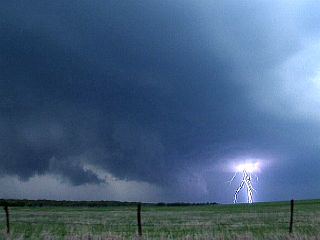
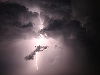
An intense cloud to ground (CG) lightning strike occurs on the forward flank of the supercell storm in Warren County, Kansas. Note the wall cloud (center) and RFD shelf cloud to the left. |
|
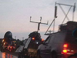
Several notable storm chasers and their vehicles can be seen in Warren County, Kansas near Altoona. The Doppler On Wheels (DOW) is to the left, the new Tornado Intercept Vehicle (TIV II) in the middle, and storm "scout" vehicle to the right. Josh Wurman and Sean Casey are the brilliant researchers working in these vehicles. |
|
This is a view of the supercell storm in Warren County, Kansas as it was beginning to evolve to HP (high precipitation) mode. In this view, we see a large wall cloud (view is to the NW) and developing RFD slot to the left. To the right, a funnel / possible tornado can be seen. |
|
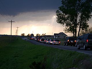
Here is a picture showing the traffic jam of storm chase vehicles, comprised of both amateurs and funded scientists, that can jam an otherwise rarely traveled rural road. The supercell storm acts as a "beacon", attracting chasers from miles around. |
|
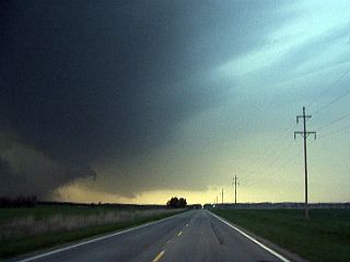
This is the supercell in HP mode about 5 miles south of the intersection of highways 39 and 75 (looking north on 75). The notch of the storm is to the left side of the picture, and an RFD core (or "blob") of heavy precipitation is obscuring the view of a possible tornado. Note the inflow "beavers tail" in the background and near the ground, extending from right to left. I knew this storm was wrapping up (intensifying), so I blasted north to get a better look at it. |
|
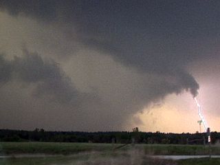
Here is a closer view of the wet RFD, which is actually the southern part of the "hook" of the storm. A tornado is inside the "bears cage" of the storm, and is not visible as the rain and hail block the view of it from this vantage point. The tornado inside would be behind the grey rain, and to the left of the center of this picture. My goal is to get past the rain "hook" and look to the west into the notch to see the tornado, which is EXTREMELY dangerous on HP supercells like this. |
|
This is one of the tornadoes that touched down, and was actually a sub-vortex in a larger, broader circulation deep within the notch (or "Bears Cage") of the HP supercell storm. This was near highway 75 and 39 intersection in Warren County, Kansas. Falling rain and hail make the contrast poor, and no one else chasing this supercell probably even knew this tornado was in there! |
|
This is a picture of a cloud to ground (CG) lightning strike on the backside of the thunderstorm cluster in SE Kansas after the last supercell storm weakened. |
|
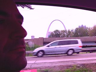
This is a picture of myself driving and passing through and around Saint Louis, Missouri to Interstate 55 in Illinois to head to northern target instead of southern (unreachable) one. The Gateway Arch can be seen from I-55 looking west in Illinois after crossing the Mississippi river. |
|
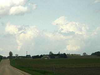
Some small LP / mini-supercell (low-topped) type storms go up along the warm-front near the Illinois / Wisconsin border as low pressure and cold air aloft (cold core) approaches from the west. These small storms did not grow very big, and soon dissapated after this picture was taken. |
|
This is the rain-free base and small scud tag / funnels developing west of Warren, Illinois and is associated with the approach of the cold-core system and occluding fronts. |
|
Interesting rear-flank downdraft (RFD) feature on one of the cells as it moves into and near Gratiot, Wisconsin. Note the wall cloud behind the clear-slot (sun is peeking through the downdraft "hole"). |
|
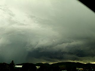
As the cold front and warm front occlude, the storm cluster quicky becomes linear (outflow dominant). The backside has some pretty structure, especially with the afternoon sun hitting the back of the shelf cloud / gust front. |
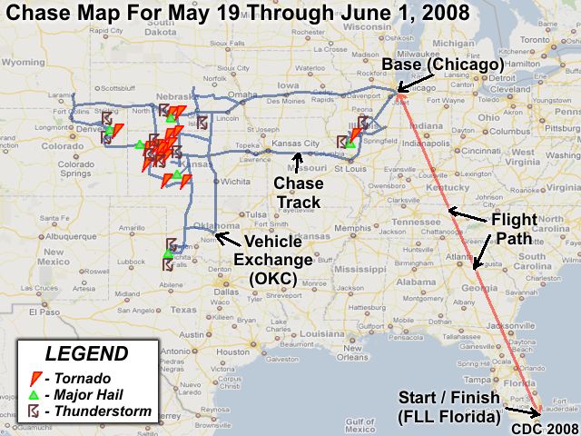
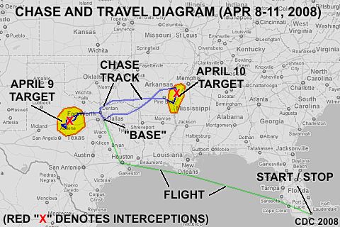
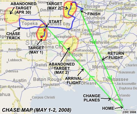
Above is a chase map (note the "hot spots!") showing the chase track, including the flight out of Florida (Fort Lauderdale) to Chicago (and back), shown in red, then the chase out to (and within) "tornado alley" (in blue). Without a doubt, Kansas was particularly violent during this chase trip, with a "cluster" of tornadoes in the west-central portions of the state. Another "batch" or tornadoes is logged near the I-80 corridor in Nebraska as well. Other than major outbreaks, some storms were also intercepted in NE Colorado, SW Oklahoma, Texas, and Illinois. The chase track (in blue) looks rather simple, but is constituted by thousands of miles because the SAME chase track was overlapped more than once, especially in Kansas. There was a total of 14 travel days, of which, 13 of these days were available for chasing (day 14 was a travel day). In these days, there was 9 chase days, 4 travel / down days, and 1 "bust" day (where only weak storms formed). The storm intercept team involved this year consisted only of myself and was be "based" out of Chicago, Illinois where I flew out to on May 19, 2008 and chase until June 1, 2008.
![]() Read In Detail For May 23 In "Quinter KS - A Tornado Chaser's Story"
Read In Detail For May 23 In "Quinter KS - A Tornado Chaser's Story"
| CHASER NAME | HOME CITY | CALLSIGN | CHASE DATES | OCCUPATION |
| CHRIS COLLURA | MIRAMAR, FL | KG4PJN | 5-19 TO 6-1 | IT CONSULTANT |
The participants below often actively participate in our storm research efforts and deserve appreciation for their great help and severe weather expertise.
| CHASER NAME | HOME CITY | CALLSIGN | OCCUPATION |
| BRANDON JOHN | HAYES, KS | N/A | OIL WORKER |
| DOUG KIESLING | MINNEAPOLIS, MN | N/A | BNVN PRESIDENT |
| TIM SAMARAS | DENVER, CO | N/A | SCIENTIST / ENGINEER |
| TONY LAUBACH | DENVER, CO | KW0LFF | STUDENT |
| VERNE CARLSON | DENVER, CO | KB0ZCQ | IT |
Please note that several other chasers have caravaned or "converged" with my group during this trip ... Most notably was Tim Samaras's group and the TWISTEX team. TWISTEX is an acronym for "Tactical Weather Instrumented Sampling in or near Tornadoes or thunderstorms EXperiment". You can find out much more about the TWISTEX group at the link provided HERE. A very interesting account of in-situ tornado observations, including some that inflicted damage on my chase vehicle as well, can be found at the link HERE!
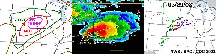
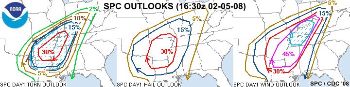
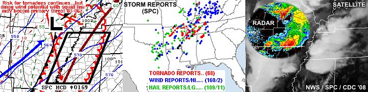
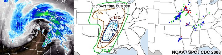
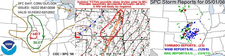
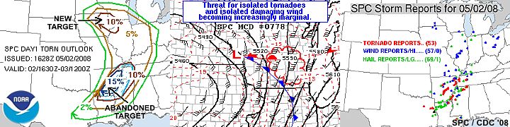
Above: Just one of the amazing chase days on this trip - May 29, 2008. Hish-risk depicted on the SPC outlook (left), a violent supercell near Beloit, Kansas on the radar scope that same day (center), and the storm reports for that day (right). It is these types of setups and chase days that storm chasers long for, but at a great cost to life and property of those who are caught in the path of America's ferocious storms.
The following entries are all storm chases and interceptions performed in the Midwest United States from May 19, 2008 to June 1, 2008. This log is based on a solo effort of a storm chasing team. Members were myself - Chris Collura (Florida Skywarn storm spotter code B036 - KG4PJN). The main chase vehicle was both a a 2007 Chevy HHR and (2007 Kia Rio). States chased (includes travel states): CO, IA, IL, KS, MO, NE, OK, SD, TX, and WY (10 states). Total mileage: 6,250 Miles (Mileage accrued on the first vehicle was 4,110 miles and an additional 2,140 miles ws put on the second vehicle. The first vehicle was exchanged in Oklahoma City for hail damage on 5-28 for the second used for the rest of the trip)!
Communications employed are HF and VHF HAM radio, FRS hand-held radios, wireless Internet, and cellular phones. Most importantly, the ability to shoot HIGH DEFINITION video is once again possible on this trip! We also used other state-of-the-art video and camera gear, GPS, and a laptop computer for navigation, video / photo editing, and Internet. The main chase duties are shifts in navigation using the GPS, radio communications, driving many miles, editing footage, and preparing forecast data. Some footage was even forwarded in MPG format to BNVN for video / broadcasting on networks such as the Weather Channel.
I flew into Chicago, Illinois on May 19, 2008 in the mid afternoon (around 1:00 PM) and to pick up the rental vehicle. The first target area, near NE Colorado, was not met until May 21, so plenty of travel / down time was experienced the first 2 days of the trip. My return flight on June 1, 2008 left Chicago in the early morning (about 6:30 AM) and returned to Florida concluding the trip. The chase involved large expanses of the US Great Plains sometimes in the worst driving conditions imaginable, even in very remote regions.
All chases and observations are in chronological order and a chase number is assigned to each entry. Please bear in mind that all observations adhere to modern storm analysis standards and do not include all storms that occurred in a given area for a particular chase period.
Any kind of storm such as a thunderstorm, tornado, waterspout, tropical cyclone, and extratropical storm can be chased or observed. I have tried to keep this log of any storms that I have observed as accurate as possible, while using terms and expressions to abide by those used by most meteorologists and storm spotters today.
Storm chasing and observation can be extremely dangerous and may result in serious injury or death. I have received intermediate and advanced training for storm spotting in 1996. I strongly urge anyone who is to try their hand at storm spotting to get training before doing so. You must also have a good understanding of meteorology and storm dynamics. "If you don't know what you're doing, Don't do it!" Contact your local National Weather Service office for information on storm spotting and about training to become a Skywarn storm Spotter.
May 19 - Arrival day. Arrived at Chicago's Midway airport and picked up rental vehicle. I was planning on spending the evening here and headed out the following day with activity expected in western Nebraska on May 21 and after.
May 20 - Today was strictly a travel day to get into position for potential severe weather on the high plains (western Nebraska) expected on May 21. I set up the rental vehicle with the equipment, and left Chicago via I-55 and I-80 at about 11 AM. I continued west on I-80 out of Illinois, through Iowa, then into Nebraska. I arrived in North Platte for the night at about 11 PM and based on data, the target area for May 21 (the next day) was set to be western Nebraska / Eastern Wyoming.
May 21 - This day was intended to be a marginal chase-day but turned out to be quiter busy. I left North Platte and headed west on Interstate 80 with a primary target of Cheyenne, Wyoming. This region is where good upslope flow was developing with a low pressure system, and was outlooked by SPC (Storm Prediction Center) in a slight-risk. I arrived in Cheyenne by 1 PM CDT and reviewed data. It became apparent that storms might develop slightly to the southeast, east of Denver near Weld and Yuma counties in Colorado. I headed south on I-25 then took Highway 34 east towards the developing storms. A dryline was becoming established, with a dewpoint gradient of more than 20 degrees encountered across it. The first supercell of the day, an LP storm, was intercepted in Yuma County near Highway 34 west of Wray at about 6 PM. Many storm chasers were on this storm, and I met with Tony Laubach and Bill Hark there as well, among others. After that storm weakened, I headed east on Highway 34, then south on Highway 385 anticipating more storms developing to the south. I headed west via a county road then south on Highway 59 to Interstate 70, where another supercell storm was encountered near Stratton at about 8 PM. After this storm weakened, I headed east on I-70 and made Hays, Kansas for the night by 11:45 PM, meeting up with Doug Kiesling. Hays is also the target area for an extreme weather setup expected the following day on May 22.
May 22 - Today was a very busy and productive chase day, with at least 4 tornadoes observed in west-central Kansas. In addition to the multiple storms intercepted, no long-distance drive was needed as activity remained west of Hays, Kansas. After forecasting in the morning, Doug Kiesling and I left Hays during the late morning. The Storm Prediction Center had a moderate risk outlook in place for west-central Kansas with a 15% hatched tornado, 45% hatched hail, and 30% damaging wind probability. This was later upgraded to a high-risk outlook late in the day. By early adfternoon, mesoscale discussion #970, then PDS (particularly dangerous situation) tornado watch box #335 was issued for the area. We pretty much waited for initiation, which ocurred by about 3 PM along the dryline and the first supercell storm was first encountered near Dighton, Kansas and followed northward along highway 23 until it weakened. This first storm produced a large wall cloud with funnels / possible tornadoes. A second storm was encountered to the SW of Oakley with another small funnel and large hail. After heading east on I-70, a third storm was encountered near Grinnell which produced a very beautiful tornado. A fourth supercell near I-70 and Collyer produced another small tornado plus a large dusty wedge type tornado that crossed I-70. This storm was tracked northward on Highway 283 until it evolved to an HP / line segment and weakened. A fifth storm was encountered near sunset south of Wakeeney and another cone type tornado was encountered there. The chase was wrapped up with dinner / chaser convergence (Verne carson, Tim Samaras, Tony Laubach, plus many others, including Chuck Doswell) back in Hays. The night was spent in Hays again, as the target for May 23, also expected to be another chase day, will be only slightly north of the area.
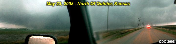
May 23 - This was another busy, extremely exciting, and terrifying chase day in nearly the same area as the day before, in west-central Kansas. The day began by leaving Hays at around noon and heading west towards Utica. Doug Kiesling and Brandon John also accompanied me on this chase in separate vehicles. Conditions were similar to the day prior: A Colorado low pressure system, strong winds aloft with directional shear, high CAPE, and a dryline / warm-front boundary "triple point". The Storm Prediction Center had a nearly identical moderate risk outlook with the tornado probability at 15% hatched, hail at 45% hatched, and wind at 30%. By about 2 PM, the SPC issued mesoscale discussion #986 and then PDS tornado watch #341 for most of western Kansas. Storms initiated southwest of Utica in Ness County, Kansas and quickly became supercellular by 3 PM. One supercell was tracked from Ness County and north into Gove County, until it finally intensified near Quinter and produced very large tornadoes. Doug Kiesling and myself were separated after documenting the tornadoes (one was a mile-wide wedge), and a window was broken on my vehicle. After this storm weakened, attention was focused on new development to the south, and another tornado was intercepted east of Gove, Kansas. After this storm moved north, my companion Brandon and I attempted to follow it, but got stuck in deep mud on a country road north of county road 466. We had to walk 2 miles to a local’s home and ask if he can help. He was more than happy to help, and tried to haul our vehicles out, but called friend of his with a farm tractor to finally get us out. This took about two and a half hours, and finished chasing for this wild day. Doug Kiesling continued to Salina, Kansas for the night while Brandon and I spent the night in Hays at his place after dinner with MANY other chasers in town. Forecasted for the next days target and also put into perspective that it is a miracle no one was killed near Quinter on this extreme chase day!
May 24 - As any luck-of-the-draw goes, the "winning streak" of intercepting tornado after tornado the past chase days ended today. After waking up early, Brandon and myself targeted southeastern Nebraska as a good chase target for the day. The Storm Prediction Center (SPC) had a slight-risk in place, with a 10% tornado probability, 45% hatched hail probability, and a 30% damaging wind probability. This forecast did not change very much throughout the day for the areas of SE South Dakota to extreme NE Kansas. Our area of interest was in SE Nebraska, where a narrow axis of moisture and instability was advecting northward ahead of a dryline. Upper air support was also in place, but a strong cap existed in the wake of an earlier MCS. We left Hays and went north on Highway 183 from Kansas and into Nebraska, making an eastward trek on Interstate 80. The dryline was crossed east of 183, and a 20+ degree dewpoint change was encountered with cumulus clouds east of the boundary. We stopped at Grand Island near Highway 281 for lunch, and met up with Doug Kiesling, Verne carson, Tony Laubach, and Tim Samaras's group. We waited there for initiation, as SPC issued mesoscale discussion #1003 and then tornado watch box #349 with our area in it's center. The cap failed to break. A weak squall line developed to our north, but not much ahead of the dryline, except for small LP type supercell with a low-topped structure that did not survive very long. Meanwhile, with 90% of storm chasers "suckered" to this failed northern target, an isolated supercell in Oklahoma (along an outflow boundary and dryline in a low-shear environment) became a prolific tornado producer. We called off any attempts to chase this target and considered it a bust. Doug Kiesling and Brandon returned home (for work). I met up with Tim Samaras's team, Verne carson, and others in Lincoln, Nebraska for dinner and to share a room for the night with Verne and his group. I also shared some video of my wedge tornado the day before with Tim Samaras's scientific group. Possible chase prospects for the next day can either be in Iowa or even back in Kansas.
May 25 - Today was a chase day with two targets to choose from. One, the original Iowa target. The other was a new target area in western-central Kansas (near Hays and points to the southwest) in response to a new surface low developing there. Since chase prospects in Kansas were to be good for at least 2 days, we decided to target the Kansas location. SPC outlooked this area with a moderate-risk, along with a 10% hatched tornado, 45% hatched hail, and 45% damaging wind probability. We left Lincoln after a forecast briefing in a caravan (Tim Samaras's team and National Geographic's film crew was also with us) with a fuel-stop in York, Nebraska. We then headed south on highway 81 through Hebron into Kansas, then west on I-70 towards the target area. SPC issued a mesoscale discussion (MD #1020) and subsequent tornado watch box #357 valid until 6 PM CDT for SW Kansas. This was later expanded eastward by MD 1024 and watch #361 valid until 10 PM CDT. A supercell storm developed ahead of the dryline and south of a sagging cold front by 2 PM CDT. We reached Wakeeney, Kansas and dropped south on highway 283 then began to follow the original storm via highway 4 to the west. A new a bettern defined supercell developed to our east, so we went back on highway 4 and penetrated its core to get to the inflow side near La Crosse, where a tornado was observed. After the supercell weakened, a large cluster of thunderstorms developed, and the system became outflow-dominant. We finished chasing south on 183 near Sanford and countinued south to highway 56, and went northeast through torrential rains to Great Bend, Kansas, for dinner and to spend the night.
May 26 - This day was another exciting chase day that began with a target area near Dodge City, Kansas and eastward. After a quick forecast, southwest to south-central Kansas had backed winds, good moisture, and very high CAPE by late afternoon. After waking up early, and with the target less than 2 hours away, Verne carson and one of the Tim Samaras mesonet crew (Bruce) left Great Bend and decided to do a damage survey near Quintar, Kansas. Meanwhile, SPC had a moderate risk including south-central to SW Kansas and a tornado probability of 10%, a 45% hatched hail, and 45% hatched damaging winds. I decided to break off first, and headed back east on I-70 to Wakeeney to drop south on 283 to Dodge City. Verne left a bit later, leaving me solo for this day. SPC issued mesoscale discusssion # 1047 then tornado watch #347 valid until 8 PM CDT by 2 PM. Initiation began after 3 PM near Garden City, then a severe storm cluster developed near Jetmore. An isolated cell initiated near Clark County and became the "tail end charley" type storm. This storm was intercepted in Kiowa and Pratt counties (with the chase track passing through Greensburg). Two tornadoes were intercepted in this area, the latter being east and a longer lasting cone tornado. This success came with great cost due to the "car-crunching" effects of the giant hail with this storm! There were many chasers on this southern-most storm. After the storms weakened, I decided to stay in Kingman for the night, after running into Dan Robinson and his chase buddies while grabbing a bite to eat and uploading video to Doug Kiesling (BNVN). The chase vehicle needs a new windshield after this day.
May 27 - Today was originally supposed to be a down day but turned out to be a marginal-setup chase day from southwest Oklahoma into extreme northern Texas (near the Red River). Morning forecasting revealed an outflow boundary draped southward into Texas, with a cold front approaching the area from the northwest. A moisture axis, with CAPE of 3500, extended into extreme SW Oklahoma and the "bend" in northern Texas. The Storm Prediction Center had a slight risk out for this area, with a small 5% tornado probability, 30% hail probability, and 15% damaging wind probability for the target area, which was assumed at the time to be near Altus, Oklahoma. I was chasing solo today, and after filing a damage claim for the rental vehicle, I left Kingman before noon and headed west on highway 54 / 400 to Pratt, then south on Highway 281 through Medicine Lodge and into Oklahoma. I was pulled over just south of Waynoka by law enforcement and cited a $150 fine for driving with cracks in the windshield. This caused a 30-45 minute delay. By 2 PM, SPC issued mesoscale discussion #1062 then severe thunderstorm watch #380 for a portion of Oklahoma and Texas, with Altus centered within it. I continued south on 281 then on 183 out of Seiling. A small supercell storm was noticed west of Clinton, but was abandoned in hope the original (Altus) target verifies. In Hobart, I took hoghway 9 west, then 44 to connect with highway 283 south of the Wichita mountains and approached an intense supercell storm when coming into Altus. The storm was observed south of town, until it weakened. Continuing south, and crossing the Red River into Texas, another severe storm was intercepted near Vernon along Highway 70. After this storm moved on and weakened, I turned around and headed back north on 70, back into Oklahoma exactly the same way I came, until I hit Clinton, then headed east on I-40 to spend the night in Oklahoma City. The rental, with major damage, will be exchanged at Will Rogers World Airport the foillowing day, which is expected to be a down / re-positioning day.
May 28 - Today was a day strictly to take care of the problems with the Chevy HHR rental and pick up an exchange vehicle (A 2008 Kia Rio) at Oklahoma City's Will Rogers Airport, then begin the long repositioning farther north for another round of severe weather the next couple of days. Checked out of the motel at Oklahoma City and exchanged the vehicle, then went up I-44 to I-35 / I-135 through Oklahoma and Kansas, then Highway 50 / Highway 81 into Nebraska to spend the evening in York. Based on forecasting, this area looks to be in store for supercells, and already had a 30% hatched outlook on the day 2 SPC product. Today did not go without storms, as New Mexico had some tornadic supercells near Tucumcari, but there was no intent to chase there today anyway, especially with the chosen chase prospects nearly 1,000 miles away in the northern Plains for 5/29 and 5/30.
May 29 - This was a chase day to remember, for a while at least. Morning forecasting revealed a very potent severe weather setup, with low pressure developing to the west in Colorado / Wyoming and very strong wind fields combined with a dryline, warm-front, and very high CAPE and very high speed + directional shear (helicity). This conditions existed from NW Kansas through E Nebraska. A nightime MCS also was weak, and in its wake, there was nearly no effect on the days instability. Meanwhile, SPC had a high-risk outlook, with a 30% hatched tornado, 45% hatched hail, and a 45% hatched wind probability. I left York and began a westward track along I-80 to about Lexington, and was there by about 2 PM. By 230 PM, SPC issued mesoscale discussion #1081 and subsequent PDS tornado watch #386 for a large portion of central Nebraska and Kansas. While waiting for initiation, I wandered around Lexington, then Kearney and saw a supercell storm (75 miles to my SW) pop up on radar. The chase was on. This storm was picked up well SW of Kearney near Bertrand and followed NE. This is the storm that eventually produced a damaging tornado that struck Kearney. After this storm weakened, a southern-most supercell storm was noted near I-70 east of Colby, Kansas. This storm was a long shot, but worth the 100 mile trip down highway 14 to catch it. It was observed producing multiple tornadoes near Beloit. I was also able to meet up with Verne Carlson, Tim Samaras (and his team), and Tony Laubach near Beloit. A final bout of the supercell was a direct hit with a small tornado on the chasers with Tim Samaras getting stuck in mud. The chase was wrapped up by traveling to near Randall, Kansas (Randall and Jewell had no power, Jewell had damage as well) and retreating down highway 24 then highway 81 to Salina, Kansas for the night near I-70. The next day will be a long trip back east.
May 30 - Today was a long re-position from central Kansas via I-70 back east through Kansas City, then Saint Louis, Missouri, and into Illinois for another chased in the central portion of that state. Left Salina, Kansas very early and made Saint Louis by about 1 PM CDT. Took I-55 north to the primary target area of Springfield, Illinois. I was able to do some forecasting en-route and pin-pointed an area of surface convergence ahead of an outflow boundary from storms in northern Illinois earlier that day. Meanwhile, a strong southwest wind aloft and shortwave trough was approaching from the west, with very good surface heating taking place (2,500 CAPE). The SPC issued a moderate risk area, with tornado, hail, and damaging wind probabilities at 15, 30, and 45 percent, respectively (nothing hatched). By 1:30 PM CDT, SPC issued mesoscale discussion #1098 and subsequent tornado watch box #394 for central Illinois centered near the primary target area (Springfield). Storms began developing ahead of the stalled outflow boundary north of Springfield and south of Bloomington near I-74 / I-55 and points south. These storms began as multicell storms but became supercellular later in the day as surface heating was maximized under the approaching upper-air support. From near Lincoln, IL and southwest towards Jacksonville (west of I-55 and near I-72) a total of 4 powerful supercell storms were intercepted, some producing small tornadoes. The chase was wrapped up in the early evening with a trip back north on I-55 and the night spent in Chicago, Illinois off Interstate 80. This was the last day spent chasing as the next day had activity in Oklahoma or on the US East coast.
May 31 - This was a down / off day spent in the Chicago area editing chase logs and packing / preparing for the trip back to FL early the following day.
June 1 - Departure day. Left Chicago's Midway airport (after returning rental) on very early flight back to Fort Lauderdale, Florida.
1). May 21, 6:00 PM - Observation and indirect penetration of a severe thunderstorm near Wray, Colorado along Highway 35 in Yuma County. The storm was an LP supercell storm that developed ahead of a developing dryline. The core of this storm contained hail up to half-dollar sized, but this region was not penetrated. Conditions encountered were winds over 60-MPH, moderate rain, lightning, and hail up to nickel sized. A small funnel was also observed on the rear flank of the storm. Conditions producing the storm were a developing dryline boundary, strong upper trough, a lee surface trough (developing Colorado low), upslope flow, and surface heating. Documentation was still digital pictures and HD video. A 2008 Chevy HHR was used to chase the storms. A severe thunderstorm watch was in effect for the area until 10 PM MDT.
2). May 21, 8:00 PM - Observation and penetration of a very severe thunderstorm near Stratton and west of Kit Carson, Colorado at the intersection of I-70 and Highway 59 in Kitt Carson County. The storm was an HP supercell storm that was part of a cluster of severe thunderstorms. Conditions encountered with this storm were winds near 70-MPH, very heavy rain, frequent lightning, and marble-sized hail covering the ground. A large wall cloud (possible tornado) was also observed with this storm north of Stratton. Conditions producing the storm were a dryline boundary, strong upper trough, developing Colorado low, and surface heating. Documentation was still digital pictures and HD video. A 2008 Chevy HHR was used to chase the storms. A severe thunderstorm watch was in effect for the area until 10 PM MDT.
3). May 22, 4:00 PM - Observation of a very severe thunderstorm from near Dighton and into Gove, Kansas mainly along Highway 23 and into Gove County. The storm was a classic supercell storm that evolved to an HP supercell and produced numerous rotating wall clouds and funnels. The storm core had large hail and high winds, but was not penetrated. Conditions producing the storms were a dryline boundary, strong upper trough, Colorado low-pressure system, and surface heating. Documentation was still digital pictures and HD video. A 2008 Chevy HHR was used to chase the storms. A PDS tornado watch was in effect for the area until 10 PM CDT.
4). May 22, 5:00 PM - Observation and indirect penetration of another very severe thunderstorm to the southwest of Oakley, Kansas in Gove and Logan counties south of Interstate 70. The storm updraft produced a wall cloud and small needle funnel / brief tornado. The storm passed to the north, and hail to quarter sized was encountered. Hail stones as big as 2.5" were noted laying on the ground. Heavy rains and winds gusting near 45 MPH were also observed. A large RFD clear-slot was noted with this storm as it passed north of Oakley before it weakened. The storm was a classic supercell storm. Conditions producing the storms were a dryline boundary, strong upper trough, Colorado low-pressure system, and surface heating. Documentation was still digital pictures and HD video. A 2008 Chevy HHR was used to chase the storms. A PDS tornado watch was in effect for the area until 10 PM CDT.
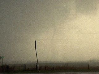
5). May 22, 6:00 PM - Observation of an extremely severe and tornadic thunderstorm to near Grinnell, Kansas in Sheridan county north of Interstate 70 and near Highway 216. This storm was a classic supercell storm, and quickly intensified and produced a tornado, which began as a truncated cone and evolved to a spectacular rope-type tornado which lasted over 15 minutes. Little damage was noted with this tornado. The storm core was not penetrated but inflow / RFD winds near 50 MPH were encountered. Conditions producing the storms were a dryline boundary, strong upper trough, Colorado low-pressure system, and surface heating. Documentation was still digital pictures and HD video. A 2008 Chevy HHR was used to chase the storms. A PDS tornado watch was in effect for the area until 10 PM CDT.
6). May 22, 7:00 PM - Observation and penetration of an extremely severe and tornadic thunderstorm to near Collyer, Kansas in Trego county from near Interstate 70 and Saint Peter Road and then northward along and near Highway 283. This storm was a violent HP supercell storm, and produced multiple tornadoes, of which at least two were observed. One tornado was a rope-type tornado south of I-70 observed in a golf-ball sized hail core while heading east on I-70. The second was a multi-vortex / dusty wedge-type tornado that crossed I-70 before the storm went north and weakened. Damage was reported this tornado, including a roof torn off a farm building. Inflow winds near 65 MPH were encountered southeast of the dusty wedge tornado on the inflow side of the supercell! As the storm weakened, the core was penetrated and 70-80 MPH RFD winds were felt in torrential rains near Hill City along Highway 283. Conditions producing the storms were a dryline boundary, strong upper trough, Colorado low-pressure system, and surface heating. Documentation was still digital pictures and HD video. A 2008 Chevy HHR was used to chase the storms. A PDS tornado watch was in effect for the area until 10 PM CDT.
7). May 22, 8:30 PM - Observation and penetration of another very severe and tornadic thunderstorm to the southwest of Wakeeney, Kansas in Trego county and near Interstate 70 and Highway 283. This storm was a classic supercell storm that quickly evolved to an HP supercell. During classic to HP evolution, another wall cloud and large funnel, then a cone tornado, was observed in the "bears cage" of the storm. This storm had continuous and violent CG lightning with many close hits, and produced winds gusting over 75-MPH, violent rains, and hail to quarter sized. Damage was done from this storm in Wakeeney, and power was knocked out as well. Conditions producing the storms were a dryline boundary, strong upper trough, Colorado low-pressure system, and surface heating. Documentation was still digital pictures and HD video. A 2008 Chevy HHR was used to chase the storms. A PDS tornado watch was in effect for the area until 10 PM CDT.
8). May 23, 5:30 PM - Observation and penetration of an extremely severe and violent tornadic thunderstorm north of Quinter in Gove County, Kansas along North Castle Rock Road. This storm was followed from its point of initiation near Ness County for a couple of hours. The storm violently intensified near Quinter because it interacted with a warm front / boundary. The storm produced lightning, torrential rains, and hail up to grapefruit-sized. The main core of the storm was not penetrated. At least three tornadoes were produced by the storm near Quinter. The first was a large stove-pipe tornado just southwest of Quinter. The second was a large circulation that became a violent tornado, nearly a mile wide, north of Quinter. At least one large satellite vortex, a large stove-pipe tornado, was observed east of the wedge-tornado that rotated around (first moved NE, then N, then NW) the main tornado. The inflow into the wedge tornado was extremely violent, downing power poles and breaking a window on the chase vehicle. Many storm chasers were in this area, some blown off the road, while others suffering major damage. Fortulately, this tornado missed the main part of any towns. Many power poles were down, and airborne farm equipment was noted (grain bin rolling across the roadway). This tornado was observed at a dangerously close range! Conditions producing the storms were a dryline boundary, stationary / warm front, strong upper trough, Colorado low-pressure system, and surface heating. Documentation was still digital pictures and HD video. A 2008 Chevy HHR was used to chase the storms. A PDS tornado watch was in effect for the area until 10 PM CDT.
9). May 23, 6:30 PM - Observation and indirect penetration of another very severe and tornadic thunderstorm to the southeast of Gove, Kansas in Gove county and near County Road 466 west of Castle Rock road. This storm was a small classic supercell storm that produced a large funnel / possible tornado. This storm had frequent lightning with some close hits, and produced winds gusting near 45-MPH, heavy rains, and hail to quarter sized. After documenting this storm, both my chase vehicle, and my companion's 4x4 got stuck in the mud and had to be towed out with a tractor. Conditions producing the storms were a dryline boundary, stationary / warm front, strong upper trough, Colorado low-pressure system, and surface heating. Documentation was still digital pictures and HD video. A 2008 Chevy HHR was used to chase the storms. A PDS tornado watch was in effect for the area until 10 PM CDT.
10). May 24, 6:30 PM - Observation of a strong thunderstorm near Doniphan in Hall County, Nebraska. This weak storm cell was a small, low-topped LP supercell. Despite rotation in the updraft, it failed to become fully developed due to a strong capping inversion aloft. The storm had a rotating structure, and typical LP appearance, but was low-topped. The storm had inflow winds to about 40-MPH and light rain. Conditions producing the storms were a dryline boundary, upper trough, low-pressure trough, and surface heating. Documentation was still digital pictures and HD video. A 2008 Chevy HHR was used to chase the storms. A tornado watch was in effect for the area until 10 PM CDT.
11). May 25, 5:00 PM - Observation and indirect penetration of a very severe and tornadic thunderstorm near Bison and La Crosse along highway 4 in Rush County, Kansas. Before being over-taken by a cluster / line of outflow-dominant storms, this storm was a classic supercell. The storm core had 50-MPH winds, hail at least golf-ball sized, and frequent lightning. One close CG hit was within 100 feet of the chase group! A rotating wall cloud with funnels was observed on the south side of the supercell after getting out of the hail core. The storm produced a small tornado near Bison, which lasted about 5 minutes. Conditions producing the storms were a dryline boundary, upper trough, low-pressure trough, cold front, and surface heating. Documentation was still digital pictures and HD video. A 2008 Chevy HHR was used to chase the storms. A tornado watch was in effect for the area until 10 PM CDT.
12). May 26, 7:30 PM - Observation and direct penetration of an extremely severe and tornadic thunderstorm along highways 183 and 54 from Greensburg to east of Pratt, Kansas in Kiowa and Pratt counties. The storm was a violent HP / classic supercell thunderstorm that developed on the southern end of a cluster of strong and severe thunderstorms. The storm was first approached from the northwest, and a large rotating wall cloud was present on its updraft (southern / rear) flank with a large funnel brief tornado crossing highway 183 south of Greensburg (the same town struck by the devastating EF-5 tornado on May 4, 2007). This tornado was brief. The storm core was penetrated while re-positioning east of Greensburg on highway 54. Hail larger than baseball sized was observed, causing numerous dents and a smashed windshield on the chase vehicle. This storm had isolated hail up to 4" (nearly softball / grapefruit sized). Torrential rains, frequent lightning with close hits, and winds gusting over 70-MPH were also encountered with this storm. The storm caught up with Pratt, Kansas and produced a cone tornado just southeast of the town. The supercell RFD occluded and evolved to a bow / line segment afterwards. Some tree damage was observed as well as flooding, and hail damage. Conditions producing the storms were surface heating, interactions with a Pacific cold front and dryline boundary, upper trough, and a low-pressure system. Documentation was still digital pictures and HD video. A 2008 Chevy HHR was used to chase the storms. A tornado watch was in effect for the area until 8 PM CDT.
13). May 27, 5:00 PM - Observation and indirect penetration of a very severe thunderstorm near Altus, Oklahoma in Jackson county near Highway 283. This storm was a classic supercell that evolved to an HP storm before weakening and becoming a cluster of thunderstorms. Conditions experienced with this storm were 50-MPH winds, heavy rains, 1/2 inch hail, and frequent lightning. A rotating wall cloud and two small funnels were observed with this storm. The supercell had a striking visual appearance, with a "stacked plate" effect. Conditions producing the storms were boundary interactions, surface heating, and a weakening upper trough. Documentation was still digital pictures and HD video. A 2008 Chevy HHR was used to chase the storms. A severe thunderstorm watch was in effect for the area until 10 PM CDT.
14). May 27, 6:30 PM - Observation and penetration of a strong to severe thunderstorm near Vernon, Texas in Wilbarger county near Highway 70. This storm was an intense cell in a cluster of strong and severe thunderstorms. Conditions experienced with this storm were winds gusting near 60-MPH winds, 1/2 inch hail, torrential rains, and frequent lightning with some clost hits. Conditions producing the storms were boundary interactions, surface heating, and a weakening upper trough. Documentation was still digital pictures and HD video. A 2008 Chevy HHR was used to chase the storms. A severe thunderstorm watch was in effect for the area until 10 PM CDT.
15). May 29, 5:30 PM - Observation and indirect penetration of an extremely severe and tornadic thunderstorm near Kearney, Nebraska along Highway 10 and Highway 30 in Buffalo County. The storm was a supercell thunderstorm that initiated south of North Platte and tracked towards the east and northeast. The storm was first picked up about 15 miles southwest of Kearney in Kearney county and followed northeast through the town. The storm produced a small tornado in Kearney County and a destructive tornado that caused extensive damage in parts of Kearney, Nebraska. The storm also had winds gusting near 80-MPH, frequent lightning with close hits, torrential rains, and hail up to golfball sized. The main storm core was grazed, but not penetrated. The tornado was observed while in Kearney and at very close range, where winds well over 100-MPH were encountered, with tree debris and parts of signs / roofs airborne. A portion of a coliseum had half its roof blown off and power poles were snapped just above the ground. Structural damage was observed in some buildings. Conditions producing the storms were a dryline boundary, strong upper trough, strong low-pressure system, and surface heating. Documentation was still digital pictures and HD video. A 2008 Kia Rio was used to chase the storms. A PDS (particularly dangerous situation) tornado watch was in effect for the area until 10 PM CDT.
16). May 29, 5:30 PM - Observation and interception of an extremely severe and violent tornadic supercell thunderstorm near Beloit and Glen Elder, Kansas along Highway 24 and near Highway 14 and Highway 36 in Mitchell County. The storm was a violent classic (and cyclic) supercell thunderstorm that produced multiple tornadoes. The storm was approached from the east on Highway 24 and presented a spectacular staked plates / mother ship structure when viewed from the northeast. The storm became a prolific tornado producer, and a large tornado (wedge) with multiple vortices (at some times 3 tornadoes / sub-vortices were noted) was observed with this storm near Glen Elder. The storm occluded, and continued northeast, causing additional damage in Jewell, Kansas. A small tornado, well south of the original large tornado (possibly anti-cyclonic) and in near darkness, took a direct hit on myself and other chasers (Tim Samaras's group) when attempting to go north on a farm road east of Highway 14. A vehicle had its windows blown out (all people involved were shaken but OK). The storm core had hail at least baseball sized, but was not penetrated. Inflow / RFD winds over 70-MPH were also observed with this storm, along with frequent lightning with many close hits. Damage observed was numerous downed trees and some damage to homes. Power was knocked out. Conditions producing the storms were a dryline boundary, strong upper trough, strong low-pressure system, and surface heating. Documentation was still digital pictures and HD video. A 2008 Kia Rio was used to chase the storms. A PDS (particularly dangerous situation) tornado watch was in effect for the area until 10 PM CDT.
17). May 30, 4:30 PM - Observation and indirect penetration of a very severe thunderstorm to the west of Lincoln, Illinois near Interstates 55 and 155 in Logan county. The storm was an HP / Classic supercell thunderstorm and a large, rotating wall cloud was observed with this storm. The main precipitation core was not penetrated, but winds near 60-MPH, heavy rains, small hail, and very frequent lightning (with many close hits) was observed. The storm produced some small funnels on its updraft side / wall cloud. Conditions producing the storms were a pre-frontal trough, strong upper trough, stalled outflow boundary, and surface heating. Documentation was still digital pictures and HD video. A 2008 Kia Rio was used to chase the storms. A tornado watch was also in effect for the area until 10 PM CDT.
18). May 30, 5:30 PM - Observation of a very severe and possibly tornadic thunderstorm near Berlin, Illinois near Interstate 72 in Sangamon county (west of Springfield). The storm was an HP / Classic supercell thunderstorm. A rotating wall cloud was observed with this storm with several funnels. The main precipitation core was not penetrated. Very frequent lightning (with many close hits) was observed with this severe storm. Conditions producing the storms were a pre-frontal trough, strong upper trough, stalled outflow boundary, and surface heating. Documentation was still digital pictures and HD video. A 2008 Kia Rio was used to chase the storms. A tornado watch was also in effect for the area until 10 PM CDT.
19). May 30, 6:00 PM - Observation of a very severe and possibly tornadic thunderstorm from near Berlin, Illinois near Interstate 72 in Sangamon county to Highway 4 in western sections of Springfield. The storm was an HP / Classic supercell thunderstorm. A rotating wall cloud was observed with this storm with several funnels. The main precipitation core was not penetrated, but 60-70 MPH (RFD) winds were observed, along with heavy rains, small hail, and Very frequent lightning with some close hits. A weak tornadic circulation was observed with this storm near Highway 4. Minor damage (trees / signs) was noted. Conditions producing the storms were a pre-frontal trough, strong upper trough, stalled outflow boundary, and surface heating. Documentation was still digital pictures and HD video. A 2008 Kia Rio was used to chase the storms. A tornado watch was also in effect for the area until 10 PM CDT.
20). May 30, 7:30 PM - Observation and direct penetration of an extremely severe and tornadic thunderstorm from near Jacksonville, Illinois south of Interstate 72 in Morgan county to near Waverly, Illinois by Highway 104. The storm was an HP / Classic supercell thunderstorm. A rotating wall cloud was observed with this storm, and a large rotating lowering (possible developing tornado) was observed off Highway 67 south of Jacksonville. The storm had very frequent lightning with many close hits, torrential rains, hail up to golfball-sized, and winds gusting over 70-MPH. Conditions producing the storms were a pre-frontal trough, strong upper trough, stalled outflow boundary, and surface heating. Documentation was still digital pictures and HD video. A 2008 Kia Rio was used to chase the storms. A tornado watch was also in effect for the area until 10 PM CDT.
This concludes the Chase Log for the May 19 through June 1, 2008 trip. During this trip, a total of 19 severe thunderstorms and 1 strong thunderstorm were intercepted. Out of the severe storms intercepted, a total of 19 tornadoes were observed (at least), a few violent. Numerous funnels were observed with other severe storms. Largest hail measured was about 4" in diameter, causing extensive damage to the chase vehicle, a 2007 Chevy HHR. A 2007 Chevy HHR was used to chase the first 14 storms, and a 2007 Kia Rio chased the remaining 6. A total of 20 storms were observed, and total mileage for this chase was 6,250 miles. Mileage accrued on the first vehicle, a 2007 Chevy HHR, was 4,110 miles. The first vehicle was exchanged in Oklahoma City for hail damage on 5-28 for the second (2007 Kia Rio) used for the rest of the trip, with an additional 2,140 miles.
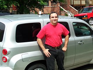
|
Here is a picture of myself and the first rental vehicle, a 2008 Chevy HHR, during vehicle setup in Chicago before heading west. |
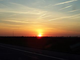
|
Here is a picture of the sun setting along Interstate 80 west of York, Nebraska during the long road-trip west on May 20 (travel day). |
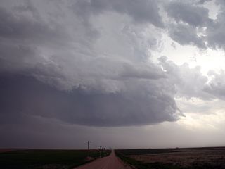
|
Here is a picture of an LP supercell updraft region in Yuma County, Colorado near Wray. |
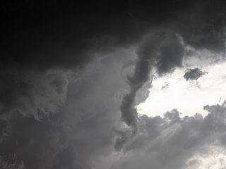
|
This is a small funnel that developed on the backside of the LP supercell in Yuma County, Colorado near Wray. |
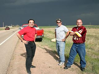
|
The LP supercell in Yuma County, Colorado drew many storm chasers. In this picture, Bill Hark takes a picture of myself, Tony Laubach, and his chase partner with the LP supercell in the background. |
|
Marble sized hail covers the ground near the intersection of I-70 and Highway 59 in Kit Carson County, Colorado from a developing HP supercell storm. |
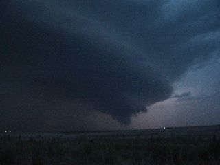
|
The supercell storm near I-70 and Highway 59 intensifies as it moves northeast near Stratton, Colroado. A large wall cloud / possible tornado appears but could not be confirmed at this point. |
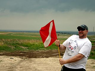
|
Chase companion Doug Kiesling (with BNVN) stands (with his dive flag) in the strong east-southeast flow during the moderate / high-risk day of May 22 in west-central Kansas. |
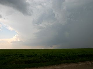
|
Here is a picture of one of the supercell storms that is developing along the dryline near Dighton, Kansas during the early afternoon. The wall cloud / lowering under the cloud base is a developing tornado. |
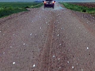
|
Large hail (up to 2.5") on the ground south of Oakley, Kansas in the wake of a supercell storm. |
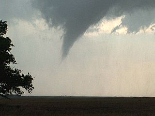
|
Here is a picture of a developing tornado on the updraft side of a small, classic supercell storm near Grinnell, Kansas. This was to produce a beautiful rope-type tornado later on in its life-cycle. |
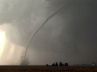
|
This is the large and impressive rope-stage of the tornado that originally developed near and moved north of Grinnell, Kansas. Note the RFD clear slot to the upper-left. After this rope-out, the same complex of cyclic supercells produced yet more (and large) tornadoes farther north near Hoxie. |
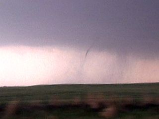
|
This was another needle / rope tornado that developed on the updraft side of a cyclic supercell near Collyer, Kansas south of Interstate 70. This is one of several tornadoes produced by this storm, and is viewed just after punching through the hail-core of the supercell. |
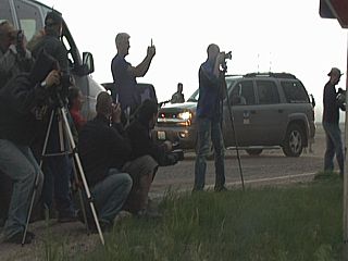
|
Many chasers, including scientists, amateurs, and tour groups alike, all watch the Collyer supercell wrap up in 60-MPH+ inflow. |
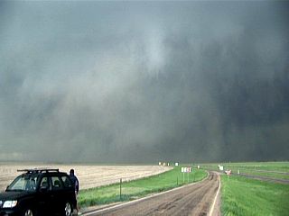
|
The supercell near Collyer, Kansas crosses Interstate 70 (wast of Voda Road) and produces this rapidly rotating dusty wedge / multi-vortex tornado. A large sub-vortex can be seen to the right just over the highway (dusty stove-pipe). This swirling mass of dust and clouds was later confirmed as a large multi-vortex tornado. |
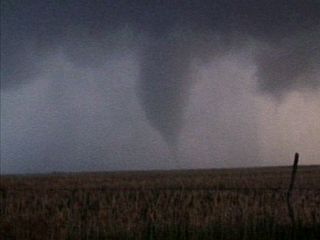
|
Yet another tornado is intercepted near Wakeeney, Kansas just south of I-70 and near Highway 283 in an HP supercell's "bear's cage"! |
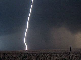
|
The HP supercell near Wakeeney, Kansas also produced incredible amounts of cloud-to-ground (CG) lightning in addition to the cone tornado. |
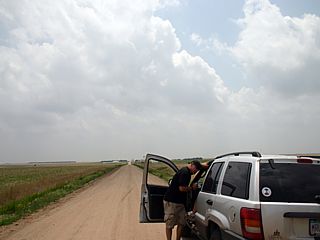
|
The first storm of the day initiates ahead of the dryline as Doug Kiesling and Brandon check data and decide to head about 10 miles west of Utica, Kansas in Ness county. |
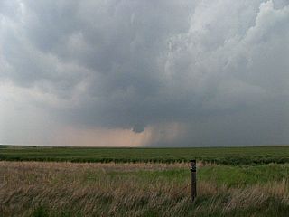
|
The storm quickly becomes supercellular, with a roatating wall cloud in Ness county. This storm cycled slightly but eventually was to become the violent HP that affected Quinter farther north. |
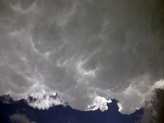
|
The storm has a rock-hard anvil with "knuckles" on its crisp edge as the supercell moves north in Ness county. |
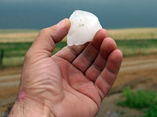
|
The supercell continues north, west of Castle Rock Road, and goes HP. This piece of large hail was found in a ditch southeast of Gove, Kansas. Hail up to 3" was confirmed with this storm at this point. |
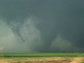
|
This is a tornado that developed southwest of Quinter, Kansas. The low-contrast shot is looking NW in very low light conditions, but a large stove-pipe tornado is visible. This is the start of a multiple tornado event (this tornado was the first "cycles" of a now cyclic supercell) that was called "Quinter #1". |
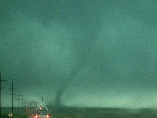
|
The violent supercell intensifies as in interacts with a warm-frontal boundary and produces a large tornado (not visible and out-of-frame to the left in this picture), and the stove-pipe satellite tornado seen in the center of the picture! This is the next of several "cycles" of the first cyclic supercell (called "Quinter #1") affecting the area. |
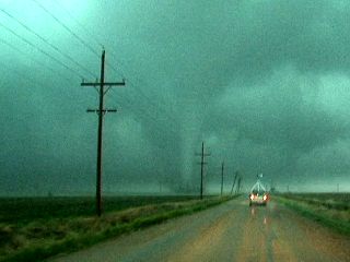
|
The large satellite (stove-pipe) tornado moves northeast, then north, then northwest (around the larger developing wedge tornado to the west). Note the mobile mesonet vehicle in the foreground (which is part of the TWISTEX group). |
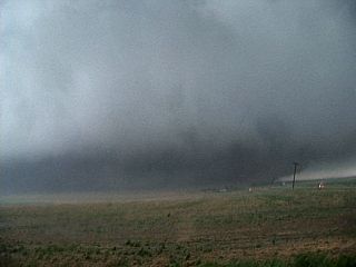
|
A large wedge (wider than it is tall) tornado tears across the field north of Quinter (fortunately for the town) as RFD winds blast and exceed 100 MPH. I am only 1/4 mile away from a tornado that is at least a mile wide! |
|
Here is the broken side window on my chase vehicle, most likely from wind-driven debris associated with the RFD (or even a small satellite vortex) south of the wedge tornado ... I got just a bit too close! |
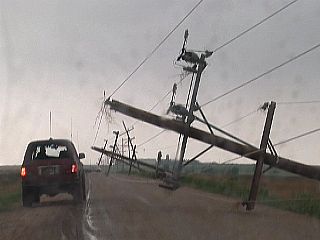
|
Power poles knocked down along North Castle Rock Road north of Quinter after the violent tornado(es) passed by. This pretty much ended the first tornado event ("Quinter #1") but was only the first "event" of a "one-two-punch" as a second (and separate supercell) tornado event (called "Quinter #2") was to follow less than two hours later - and affect almost the SAME area! |
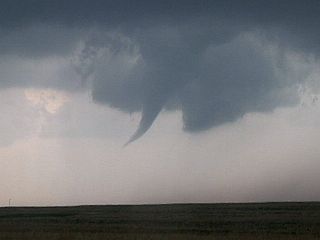
|
Here is another possible tornado that formed on the southern flank of a supercell storm west of Gove, Kansas near county road 466. This was short lived and condensed nearly to the ground. After chasing this storm, chase Brandon and myself got stuck in the mud! |
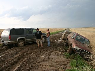
|
Supercells passing over turn these packed clay roads into stucky mud that nothing gan get out of! Both of our vehicles got stuck in the mud, ending the chase day (we missed "Quinter #2" because of this). Brandon and myself had to walk about 2 miles to a farm house where a local was kind enough to give us a hand. |
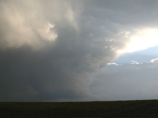
|
Supercell storms were all around us when we were helplessly stuck in the mud. This is about the time the second "round" of tornadoes was affecting Quinter to our east and northeast (15-20 miles away). In this picture, a beautiful LP supercell passes just to our west ahead of a squall line at sunset. |
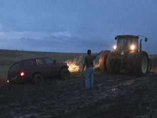
|
The local, Wess, knew someone with a tractor. That was the only vehicle that could pull us out of the mud. All he wanted was a simple thanks, did not even ask for money. I "tipped" him $100 bucks and gave him a pat on the back from getting us out of that "gunk"! This mud is basically wet clay, and has the consistancy or chocolate fudge cake mix (even your boots get stuck and lost if you step in it)! |
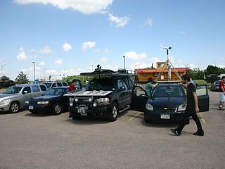
|
Here is a picture of the chaser convergence north of Interstate 80 in Grand Island, Nebraska and highway 281. The large vehicle in the center hosts scientific experiments, and Tim Samaras is working with projects with Boeing and National Geographic among others. |
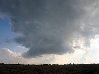
|
This small LP "mini" supercell develops ahead of the dryline to the southeast of Grand Island, Nebraska. The cell had rotation, but was low topped, moisture-starved, and failed to fully breach the strong cap. |
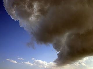
|
Here is a view of the underside of the low-topped anvil of the LP supercell near Grand Island. |
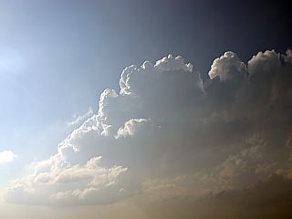
|
Another view of the small LP supercell near Grand Island. The storm failed to fully breach the strong cap, and was highly sheared. The cell dissapated shortly after this picture was taken. |
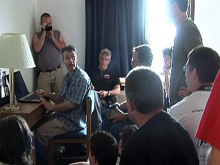
|
Members of Tim Samaras's group do a weather / forecast briefing before leaving Lincoln, Nebraska for the target in southwest Kansas. |
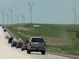
|
Heading west on Interstate 70 in Kansas, this is the caravan of storm chasers including Tim Samaras's group and a National Geographic film crew. |
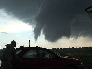
|
A rotating wall cloud appears on the south side of a classic supercell thunderstorm near La Crosse, Kansas just south of Highway 4 in Rush County. A large funnel cloud also can be seen. |
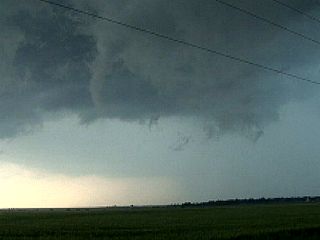
|
Here is another funnel cloud produced by the same supercell storm as it moves over La Crosse. The funnel is about half-way to the ground. |
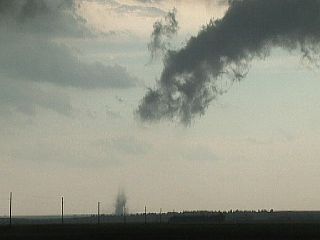
|
As the supercell moves northeast across Rush County, Kansas, it finally produces this small tornado near Bison, Kansas. |
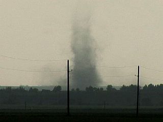
|
Here is a close-up of the debris cloud of the Bison, Kansas tornado. |
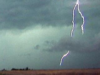
|
Cloud to ground lightning was frequent with these storms in Kansas, especially when the supercells evolved into a MCS (cluster / line of thunderstorms). |
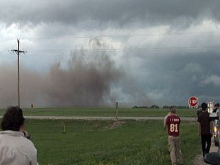
|
Here is one of several gustnadoes in the outflow dominant storms associated with the MCS near Sanford, Kansas along highways 183 and 156. |
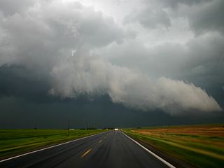
|
This is a view of the shelf-cloud and gust front associated with the MCS in Kansas. |
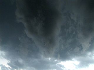
|
Just before outflow under-cuts this developing storm, a large funnel appears just ahead of the gust front shelf cloud looking up! |
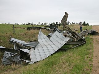
|
This is a picture of damage caused by the May 23, 2008 Quintar, Kansas tornado. We decided to do a damage survey of the area before heading to our chase target farther south. |
|
Verne Carson, right, launches an RC aircraft (remote control) carrying a digital video camera and a digital still camera. He will fly over a damage path, caused by the Quintar, Kansas wedge tornado on May 23, 2008, and take pictures of the damage below from about 300 feet. Verne calls his "drones" the "Wicked Witch" project. |
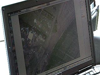
|
This is a picture of Verne carson's laptop viewing arial pictures taken of a damaged farmstead during the damage survey in Quintar, Kanas. |
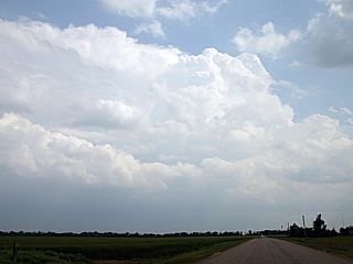
|
Here is a picture, taken from Ford County, Kansas (looking SSE into a storm over Clark County) just after developing. This storm cell was to become a supercell storm that will produce giant hail and tornadoes. |
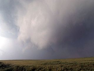
|
A rotating wall cloud produces this large funnel (and brief tornado touchdown) south of Greensburg, Kansas. |
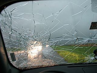
|
Hail at LEAST baseball sized smashes the windshield of the chase vehicle in the supercell core east of Greensburg sending shard of glass into my lap! |
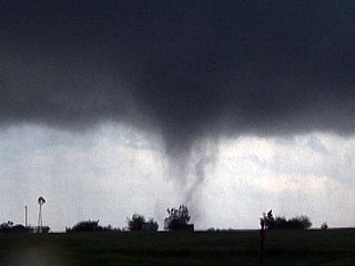
|
The second tornado was a multi-vortex cone tornado east of Pratt, Kansas. A small sub-vortex can be seen just to the right of (and very close to) the main cone tornado. |
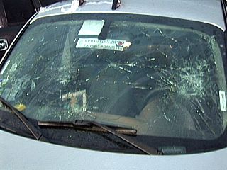
|
This is what baseball sized (and larger) sized hail in the supercell storm core did to the windshield of the chase vehicle. |
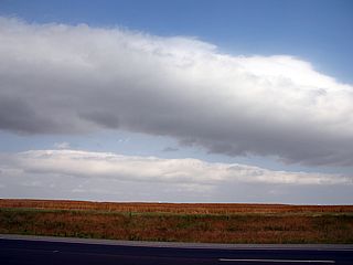
|
This is a picture of interesting cloud formations called HCR's (horizontal convective rolls). Thes are caused by rising and sinking air (in a mixing boundary layer) in bands creating horizontally oriented (aspect) rolls. The regions where air is rising can create the cloud bands if moisture conditions are right. |
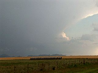
|
This is a view of the northwestern side of an intense supercell thunderstorm near Altus, Oklahoma viewed from about 30 miles to the northeast. The Wichita mountains can be seen on the horizon in the foreground. |
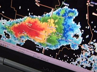
|
The supercell storm near Altus looks very impressive on the radar for base reflectivity out of Frederick, Oklahoma's radar site. Note the "flying eagle" shape of the storm. |
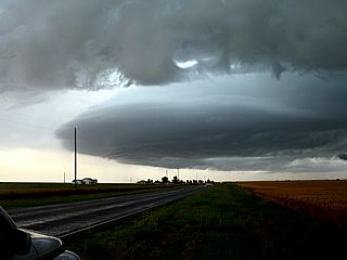
|
Here is a view of a portion of the updraft base of the supercell storm near Altus just before it weakened. The RFD bows out forming a "mothership" or "stacked plates" effect on the storm structure. |
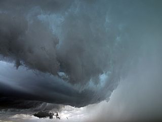
|
Here is a view of the Altus supercell vault / hail core to the right, and updraft / wall cloud to the left and lower-center of the picture. Two small funnels were produced by this storm. |
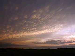
|
Here is a picture of mammatus clouds in SW Oklahoma / NW Texas on the backside of the MCS. |
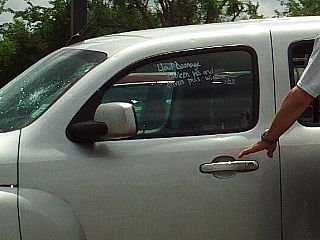
|
Here is the last of the Chevy HHR rental after swapping vehicles at Oklahoma City (Will Rogers) Airport. The vehicle has a major damage claim and probably will need to be auctioned off. |
|
Here is a picture of the second chase vehicle, a 2008 Kia Rio, all set up for the next few days of storm chasing farther north. I hope and intend to return this car in a MUCH better condition than the last, God willing! |
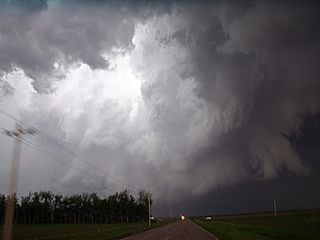
|
Here is a picture of a developing tornadic supercell, with impressive structure and RFD slot (left), that will eventually produce a tornado through Kearney, Nebraska. |
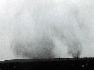
|
The storm begins intensifying, and produces its first tornadoes. In this picture, two distinct tornadic circulations are on the ground in a field south of me. |
|
Tornado approaching Kearney, Nebraska (view is to the west). The tornado is in the center of the picture. |
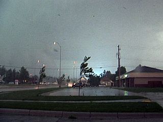
|
Power flashes as the tornado moves through Kearney. I am way too close, if not inside part of the core wind-flow of the tornado! Note the debris in the air. |
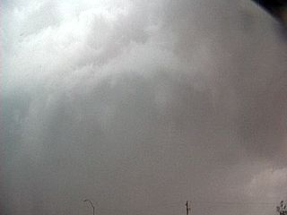
|
Looking upward at the tornadic circulation just overhead. Note the curved banding of the truncated cone tornado viewed at a dangerously close range. |
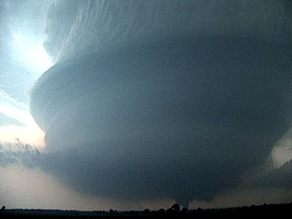
|
Here is a violent (and beautiful) supercell storm northwest of Beloit, Kansas looking southwest. In addition to such striking storm structure, a large tornado is on-going beneath the storm (bottom of picture just right of center)! |
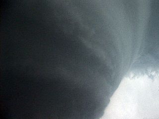
|
Incredible striations encircle this majestic supercell storm. This is the view of the northern side "stair-step" of the storm. |
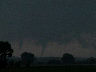
|
This supercell produced a spectacular multiple-vortex tornado. The view is to the southwest and the storm is to the SSW of Glen Elder off Highway 24. |
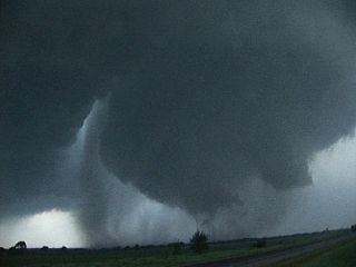
|
View of widening tornado to the west as it passes near or over Glen Elder near highway 24. Note the impressive and tight RFD slot to the left of the tornado. This was an extremely violent mesocyclone. |
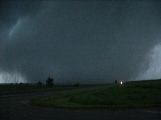
|
Wedge phase of tornado after passing by Glen Elder looking to the WNW on Highway 24. |
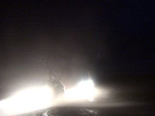
|
A smaller tornado takes a direct hit on myself and the other chase vehicles on a dirt road near Beloit, Kansas! The vehicle is actually off it's two left tires to the left! No one was hurt, but some windows were blown out in the vehicles. |
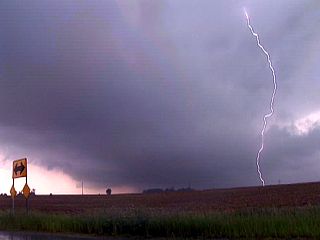
|
Here is a picture of the first supercell intercepted near Lincoln, Illinois. A large, rotating wall cloud is to the left as a cloud to ground (CG) lightning strike can be seen to the right. |
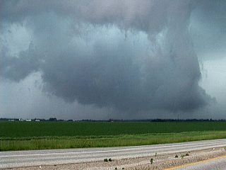
|
Large wall cloud near Berlin, Illinois on an HP supercell storm north of I-72. There is a suspicious dust swirl under the center of the wall cloud (lower-center of the picture). |
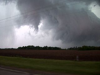
|
Another supercell storm moves to the western outskirts of Springfield, Illinois in Sangamon county with a funnel and rotating wall cloud to its right. |
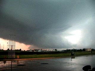
|
Here is another rotating and large wall cloud near Jacksonville, IL on yet another powerful supercell storm. |
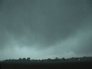
|
This is a picture of a suspicious bowl-shaped lowering on the southern side of the Jacksonville, IL storm. This feature had rotation. |

|
Severe winds (up to 70 MPH) and sideways rain and hail (up to golfball sized) affect the area between Jacksonville and Waverly, Illinois. This was on the backside of the tornadic supercell storm. |
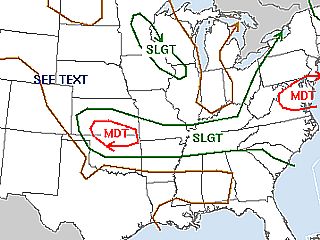
|
Today was not a chase day as I returned to Chicago to take a break. However, back in Oklahoma and Kansas, storms were still forecasted, including this moderate risk outlook forecasted by the SPC (storm predictions center). |
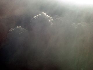
|
While in-flight and returning to Florida (from Chicago), a complex of strong and severe thunderstorms is circumnavigated over the Atlanta, Georgia area. In this picture, an updraft can be seen welling up through the sub-tropical atmosphere. |
| CHASER NAME | HOME CITY | CALLSIGN | CHASE DATES | OCCUPATION |
| CHRIS COLLURA | MIRAMAR, FL | KG4PJN | 6-22 | IT CONSULTANT |
| MIKE MENDOZA | CHICAGO, IL | N/A | 6-22 | ARCHITECT |
1). June 22, 3:00 PM - Penetration of a very severe thunderstorm in Pulawski County, Indiana near Highway 10 and Winamac. The storm was a small supercell storm developing at the southern end of a multicell cluster of strong and severe thunderstorms. The thunderstorm contained very heavy rain, large hail to the size of golf-balls, winds gusting near 60-MPH, and frequent lightning. The larger hail covered the ground at times, and downed tree limbs were noted in the street. Conditions causing the storms were an upper trough, surface heating, weak surface trough, and lake-breeze boundary (from Lake Michigan to the north). Documentation was still digital pictures and a camcorder. A 2007 Chrysler Sebring (rental) was used in this storm chase. A best friend (curious about storm chasing and living in Chicago) accompanied me on this storm chase.
This concludes the chase log for the chase trip on June 22, 2008. The summary includes a total of 1 severe thunderstorm. This information was prepared exclusively for the National Weather service and the team of Skywarn storm spotters.
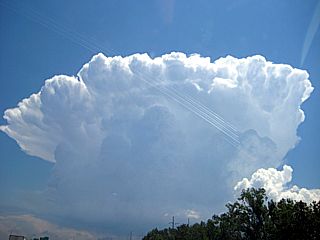
|
Here is a picture of an explosively developing supercell storm south of Interstate 80 in north-central Indiana (viewed from eastern Lake county). The storm has developed a rock hard anvl at this point. Picture taken by friend / fellow chaser Mike Mendoza. |
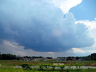
|
This is a picture of the updraft base of the storm. The storm, despite light lower-level winds, appears highly sheared because of the strong upper-level flow (bulk-shear of 40 knots+ at and above 500 MB) associated with the short-wave trough moving across the Great Lakes. Updraft base is rather high, but well developed. |
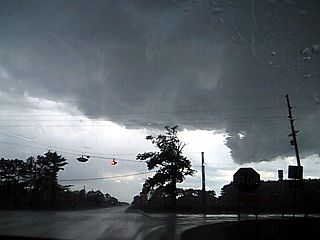
|
This is a picture of the wall clous associated with this supercell storm near Pulawski county and Highway 10 (near Winamac). This storm DID contain weak rotation, and a powerful updraft. Hail to golfball sized was starting after this picture was taken. |
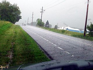
|
This small supercell storm produced a lot of hail. In this picture, taken by Mike Mendoza (chasing with me), hail to marble sized (with isolated golfball pieces) is on the ground and in the roadway (Pulawski county). Note the tree limb laying in the road. |
HTML File "mwcl2008.htm" - Developed By Chris Collura

My Contact Information Is Given In The Graphic Above
To Prevent SPAM And Abuse - The EMAIL Banner Above Only Links To My Information Page
For My EMAIL - You Will Need To Take It Down And Enter It In Your EMAIL Package
To Return To The HOME Page Of This Site Click The "INDEX.HTM" Link Here!