
Facebook Timeline Posts For June 2019
(Posts And Comments During June 2019 For Sky-Chaser Chris Collura On Facebook)
[ 2019-JUL ] [ BACK TO INDEX ] [ 2019-MAY ]
Posts And Comments For June 2019
Posted: Jun 29, 2019, 7:13 PM
Chris Collura commented on Montblanc's post.
"Can I borrow your pen?" ... "Sure."
...3 hours later...
"Of shit, who's pen is this?"
Posted: Jun 29, 2019, 7:11 PM
Chris Collura commented on Museum of Science and Industry, Chicago's post.
Should be $250,000 OFF. These prototypes aren't cheap.
Posted: Jun 29, 2019, 7:09 PM
Chris Collura commented on Van Perpetual Bloom's photo.
If I was in the area I would have been there!
Posted: Jun 29, 2019, 6:49 PM
Chris Collura commented on Sea-Doo's video.
Loved it UNTIL it broke and was denied my extended warranty. Got OUT of the sport after spending nearly $9K on a repair I shouldn't have paid for.
Posted: Jun 29, 2019, 6:46 PM
Chris Collura commented on Jack Corso's post.
Better than the centra USA / high plains the month of June ey?
Posted: Jun 29, 2019, 6:43 PM
Chris Collura replied to his own comment.
Posted: Jun 29, 2019, 6:41 PM
Chris Collura commented on a post.
Posted: Jun 29, 2019, 6:40 PM
Chris Collura commented on a post.
Posted: Jun 29, 2019, 4:58 PM
For the tornadoes intercepted over past couple weeks. Better late than never!
Posted: Jun 29, 2019, 1:49 PM
Chris Collura commented on Colt Forney's post.
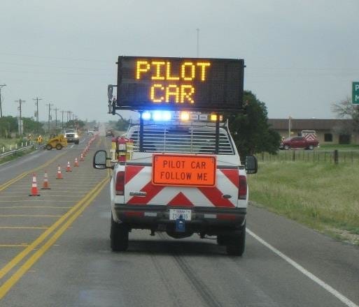
Saw a "?" on May 20 near Paducah TX (with tornadoes already in progress) saying "stopped traffic with road construction on one lane and pilot car in use"!
There are OTHER APPS for that. Not Spotter Network!
Posted: Jun 29, 2019, 11:17 AM
Chris Collura replied to Jason Foster's comment.
Jason Foster Wow I believe it. Being at so many cities all over the central USA the best experiences were in places like Omaha, Denver, even Wichita. The worst being places like Salina, Wichita Falls, OKC, and the ashtray of them all, Saint Louis.
Posted: Jun 29, 2019, 7:56 AM
Chris Collura commented on his own video.
Colt Forney probably was near it at the 0:08 mark in the video!
Posted: Jun 29, 2019, 7:53 AM
Chris Collura replied to his own comment.
https://youtu.be/uYP-uDWXoiw
Posted: Jun 29, 2019, 7:51 AM
Chris Collura commented on StormChasingVideo.com's video.
I apologize but the location should be "Sharon Springs" not "Sheridan Lake".
Posted: Jun 29, 2019, 7:47 AM
Chris Collura commented on The Missouri Redneck Storm Chasers's post.
I have experienced a microburst (a drier one) last week in Sharon Springs, Kansas and its not fun. Sand and gravel blew out nearly every window on the cars parked at a gas station. Straight line winds like this can do the same damage as a tornado.
Posted: Jun 29, 2019, 6:43 AM
Chris Collura commented on Science101's post.
Channel rockfish?
Posted: Jun 29, 2019, 6:40 AM
Chris Collura replied to Pam Chapman's comment.
Pam Chapman Lol ... I saw an abandoned, perfectly intact tent along the side of the highway in Oklahoma.
Posted: Jun 29, 2019, 6:38 AM
Chris Collura replied to Jason Foster's comment.
Jason Foster I also noticed that the general attitude and rudeness of the folks in Oklahoma City even exceeds LA or Miami now! That's really surprising but someone told me theres been a massive influx of low income / riff raff over the past 5 or 10 years. That's a crying shame.
Posted: Jun 29, 2019, 6:35 AM
Chris Collura commented on David Hoadley's album.
Awesome stuff. I think Jason Persoff has a great shot of you, me, and him in a selfie with that storm in the background. It was a pleasure running into you in the field that day! Great work!
Posted: Jun 28, 2019, 8:53 PM
Chris Collura commented on Skip Talbot's photo.
I feel you (May 28 this year was me downward drowning bomb)!
Posted: Jun 28, 2019, 7:07 PM
Chris Collura replied to his own comment.
Colt Forney Hate that shit. Garbage can right there and no one use it. Sounds like arguing constantly with my ex g/f leaving her crap on the counter top = Trash can 3 feet away. Just move your hand left instead of right and trash goes in right place. But noooh. Cant do it.
Posted: Jun 28, 2019, 7:02 PM
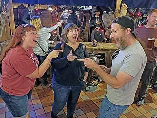
Enjoying dinner with some co workers here in the Chicago area. Thanks for hosting us here and such a great Italian dinner and drinks!Place: RoccoVino's Italian Restaurant & Vince's on Harlem (41.9670386, -87.8070103) Address: 4747 N. Harlem Ave, Harwood Heights, Illinois 60706
Posted: Jun 28, 2019, 3:44 PM
Chris Collura commented on Colt Forney's post.
I've been there few times. Hate to say that white trash leaves too much trash. Jesus ... just pick up after yourselves. Why?
Posted: Jun 28, 2019, 2:09 PM
Chris Collura replied to Doug Kiesling's comment.
Doug Kiesling I bet. No way I'm doing this.
Posted: Jun 28, 2019, 2:08 PM
Chris Collura replied to Jason Foster's comment.
Jason Foster Looks like no one else got this. That's safe to say I'll ignore this BS. These scams make my blood boil.
Posted: Jun 28, 2019, 2:07 PM
Chris Collura replied to Dave Lewison's comment.
Dave Lewison I ofcourse didnt do it ... Its just looks fraudulent.
Posted: Jun 28, 2019, 2:06 PM
Chris Collura replied to his own comment.
Dave Lewison Not just that but if you rent a car, and have a CC on file, you BETTER update it with the new one. Sometimes months later it bites you when you try to use the service and the old CC in there fails and you overlooked it.
Posted: Jun 28, 2019, 6:47 AM

I've been getting text reminders with a link like THIS!!!Is this legit? Has anyone else got this?
Posted: Jun 28, 2019, 6:19 AM
Chris Collura commented on Brad Hannon's post.
Awesome collection!
Posted: Jun 28, 2019, 6:16 AM
Chris Collura commented on Dave Lewison's photo.
The address should be easy to track. I hate this stuff. I had my CC compromised a few years back and it wasnt the charges I was responsible for but all the changes I had to do to put the new CC up (SW Airlines, Car Rental, Electric and AT&T auto pay, etc) is what took hours. One online site hit me with fees since I forgot to put the new CC on that and the payment failed. Complete hassles because of these pricks.
Posted: Jun 27, 2019, 12:51 PM
Chris Collura commented on Mike Hollingshead's post.
Posted: Jun 27, 2019, 10:59 AM
Chris Collura replied to Doug Kiesling's comment.
Doug Kiesling Or "into the storm" :)
Posted: Jun 27, 2019, 10:57 AM
Chris Collura commented on Daniel Shaw's post.
Again a heart breaking end to the chase season. Hes in a better place now and will be on EVERY storm and in all the hearts of the storm chasing community.
Posted: Jun 26, 2019, 4:13 PM
Chris Collura replied to Jason Foster's comment.
Jason Foster Oh really? Duh.
That makes sense.
Posted: Jun 26, 2019, 4:09 PM
Chris Collura commented on Derek Sibley's photo.
Looking forward to football season!
Posted: Jun 26, 2019, 11:33 AM
Chris Collura replied to Doug Crisp's comment.
This dumb FB cannot let me post a pic now? WTF?
Posted: Jun 26, 2019, 11:28 AM
Chris Collura commented on Bill Hark's video.
Posted: Jun 26, 2019, 11:27 AM

Why???FB is just getting more and more messed up!!!
Posted: Jun 26, 2019, 11:26 AM
Chris Collura commented on Ericka Gray's post.

Posted: Jun 26, 2019, 11:01 AM
Chris Collura replied to Doug Crisp's comment.
Colt Forney Thank you :)
Posted: Jun 26, 2019, 11:01 AM
Chris Collura replied to Lori Ferguson's comment.
Lori Ferguson South of Hastings, NE.
Posted: Jun 26, 2019, 10:58 AM
Chris Collura commented on Margie Kieper's post.
Theres one of those across the street from my dads place. So many times I went to Publix next door, spent a little extra, simply because the Marketplace never had the items I needed!
Posted: Jun 26, 2019, 10:54 AM
Chris Collura replied to Sarah Shinners's comment.
Posted: Jun 26, 2019, 10:52 AM
Chris Collura replied to Geoff Mackley's comment.
Sounds like another psycho back in 2001 trolling other chasers called Ricky Cates.
Posted: Jun 26, 2019, 10:51 AM
Chris Collura commented on Doug Kiesling's post.
This guy was NEVER in my friends list.
Posted: Jun 26, 2019, 8:08 AM
Chris Collura commented on Daniel Shaw's photo.
It was of great pleasure seeing you again and every year it's just another "highlight" in chasing running into you as I look forward to it.
Have a safe trip back home :)
Posted: Jun 25, 2019, 6:04 PM
Chris Collura replied to Lori Ferguson's comment.
Posted: Jun 25, 2019, 6:03 PM
Chris Collura replied to Lori Ferguson's comment.
Lori Ferguson Hard for me to sample it as I have no back window from few nights ago (gravel in 100 mph gusts) and its taped up until I get it replaced tomorrow in Chicago.
Posted: Jun 25, 2019, 6:01 PM
Chris Collura replied to Lori Ferguson's comment.
Lori Ferguson Yeah I was watching that. Had a nice hook for a while too. Looks like its upscaling to an MCS now.
Posted: Jun 25, 2019, 5:58 PM
Chris Collura commented on Mark Robinson's post.
Slam HARD into the Tropopause!
Posted: Jun 25, 2019, 5:56 PM
Chris Collura replied to Bill Hark's comment.
Ericka Gray I figured that.
Posted: Jun 25, 2019, 5:54 PM
Chris Collura replied to Lori Ferguson's comment.

Posted: Jun 25, 2019, 5:52 PM
Chris Collura replied to Bill Hark's comment.
Bill Hark Hardly anyone even saw my hurricane Michael stuff in Oct last year on FB. I actually posted it twice thinking it was broken. Just one like from a co worker. Thought it was strange. Much more audience saw it in Stormtrack and my website. FB is all screwed up.
Posted: Jun 25, 2019, 5:50 PM
Chris Collura commented on Ericka Gray's post.
I'm safe. Never even heard of this so called "Schwab" guy. I deleted FB and never blindly just added friends. Never saw nor heard of this guy until now.
Posted: Jun 25, 2019, 5:45 PM
Chris Collura commented on Brian Stertz's post.

Posted: Jun 25, 2019, 5:42 PM
Chris Collura replied to Jon Long's comment.
Jon Long Agreed. Were paying enough for taxes and gas driving, let alone paying to drive on a strip of asphalt.
Posted: Jun 25, 2019, 5:39 PM
Chris Collura commented on Billy Wade's post.
Goin UP ... Ride the elevadora!
I actually go around toll roads. Yeah maybe I pay more in gas but I have issues justifying paying money to drive on a road.
Posted: Jun 25, 2019, 5:10 PM

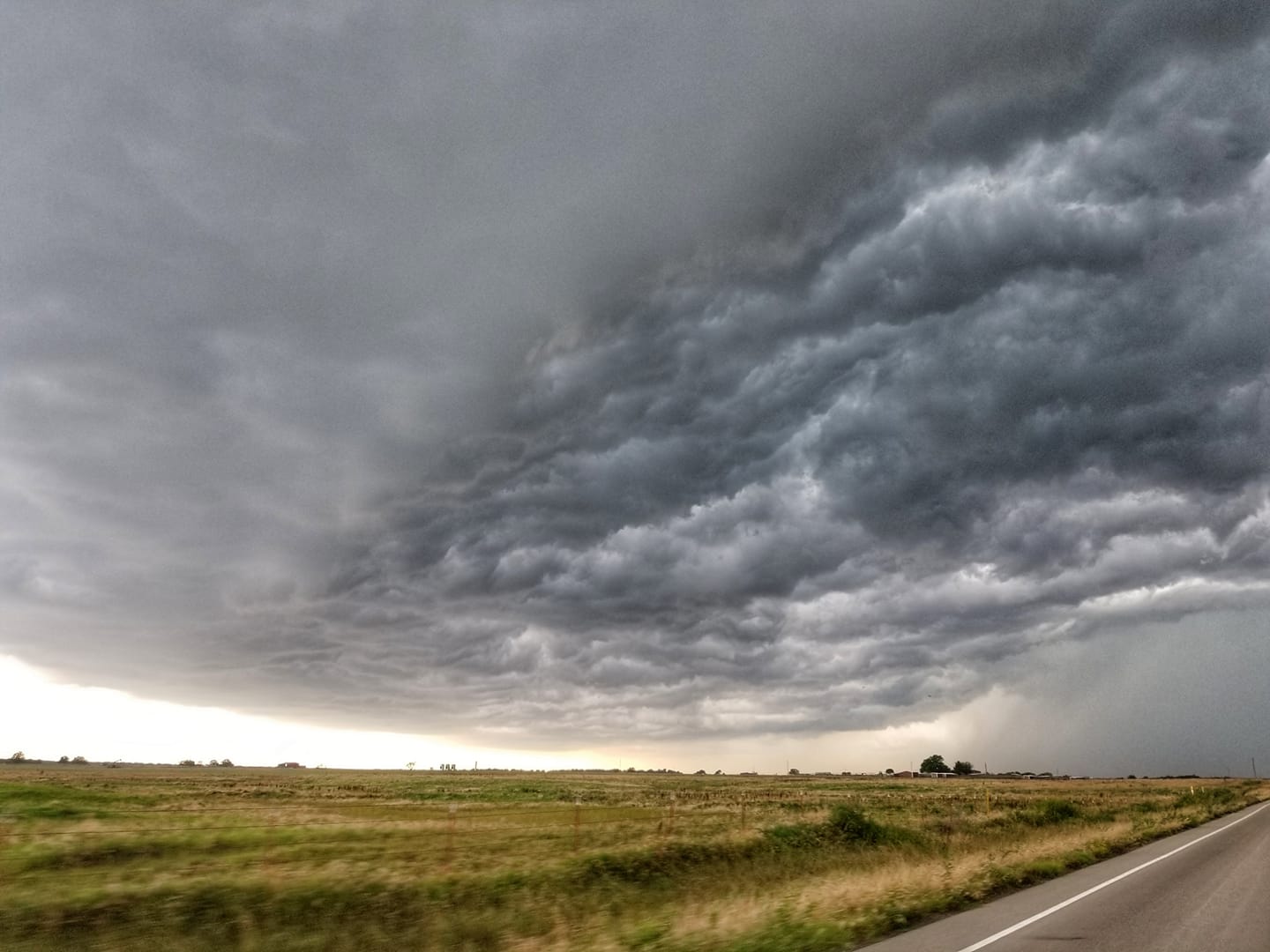
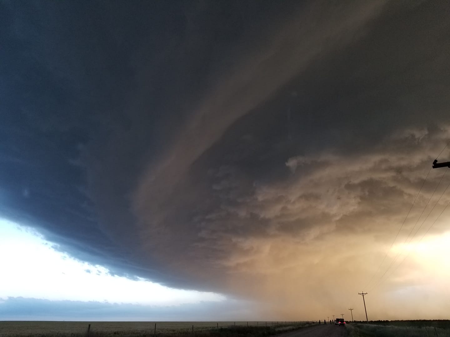
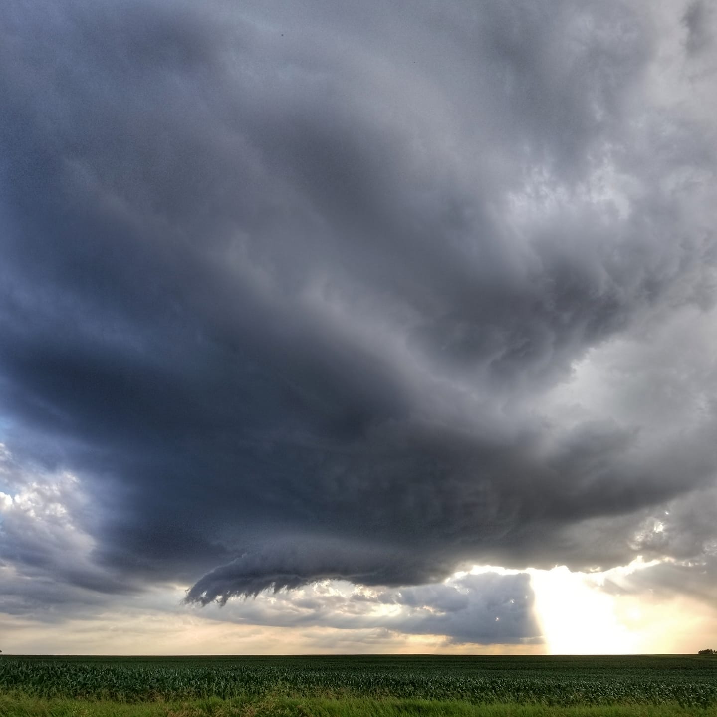
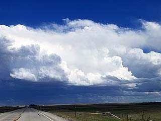
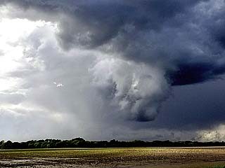
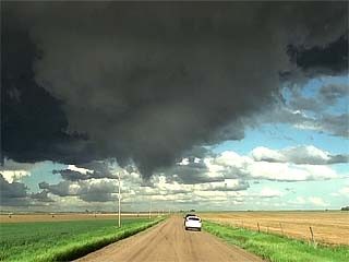
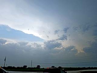
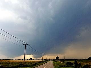
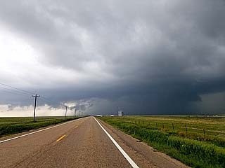
Looks like mother nature stepped on the sheet rock in heaven and her foot broke through?Hah, just a little LP supercell storm near Nuckolls County, NE during the afternoon of June 25, 2019 ;)
Posted: Jun 25, 2019, 4:55 PM
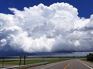
Last "official" chase of Spring / early Summer 2019 near Davenport, Nebraska. June 25, 2019 as the season winds down...
Posted: Jun 25, 2019, 4:53 PM
Chris Collura commented on a post.
Posted: Jun 25, 2019, 6:06 AM
Chris Collura commented on Groupon's post.
You can basically do this with any planet or moon with a mapped surface. To me it's worth no more than bragging rights or a marketing gimmick.
Posted: Jun 25, 2019, 5:57 AM
Chris Collura replied to Doug Crisp's comment.
Doug Crisp Isn't that Colt Forney's area of expertise?
Posted: Jun 25, 2019, 5:51 AM
Chris Collura commented on Stormtrack's post.
http://sky-chaser.com/mwcl2019.htm
Posted: Jun 24, 2019, 10:59 PM
Chris Collura commented on Doug Kiesling's post.
I dont know any Philip Schwab.
Posted: Jun 24, 2019, 6:10 PM
Chris Collura replied to Jason Persoff's comment.
Jason Persoff Fortunately it looks like it's over no mans land.
Posted: Jun 24, 2019, 6:09 PM
Chris Collura replied to his own comment.
Colt Forney I believe so.
Posted: Jun 24, 2019, 3:19 PM
Chris Collura commented on Nick Nolte's photo.
Wow. Had no idea there was even a tornado there. I was suckered deep in the hateful outflow in north / central Texas. Boooo...
Posted: Jun 24, 2019, 3:17 PM
Chris Collura updated his status.
Down / travel day today (6/24) then off to LieOwa (Iowa) to look for trolling tornadoes there. After that chasing is done for 2019.
Posted: Jun 24, 2019, 3:12 PM
Chris Collura commented on Stormtrack's post.
It's a troll. Dont under estimate trolls. They HIDE in between 2% outlooks as per SPC and can kill you.
Posted: Jun 24, 2019, 3:09 PM
Chris Collura commented on Maureen Loffredo's photo.
Wow. You look almost the same!
Posted: Jun 24, 2019, 3:07 PM
Chris Collura commented on John Thomas Moon III's post.
Is this in Kansas City? Severe CLEAR today!
Posted: Jun 24, 2019, 3:05 PM
Chris Collura commented on Colt Forney's photo.

Posted: Jun 24, 2019, 3:02 PM
Humm. I get NO ONE is on this one?Yes this is extreme SE Texas. Farthest from any dryline nor upper support you can get!#ILoveTrolls
Posted: Jun 24, 2019, 10:55 AM
Chris Collura commented on Stormtrack's photo.
Let's TRY to not flood the market with hurricane chasing. Like tornado chasing the last thing we need is everyone and his f'cking mother out there creating traffic jams and overwhelming police roadblocks.
Posted: Jun 24, 2019, 10:52 AM
Chris Collura commented on a post.
Posted: Jun 24, 2019, 9:58 AM
Chris Collura commented on Doug Kiesling's post.
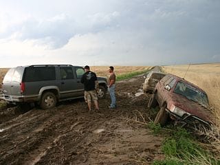
Small cuts on my legs, left ear ... And my car, oh boy. State Farm will get a hard on when they see it.
Posted: Jun 24, 2019, 9:45 AM
Chris Collura commented on Colt Forney's post.
Yeah yesterday was like blaah...
But cool pics though of the "outflow dominatrix" :)
Posted: Jun 24, 2019, 9:44 AM
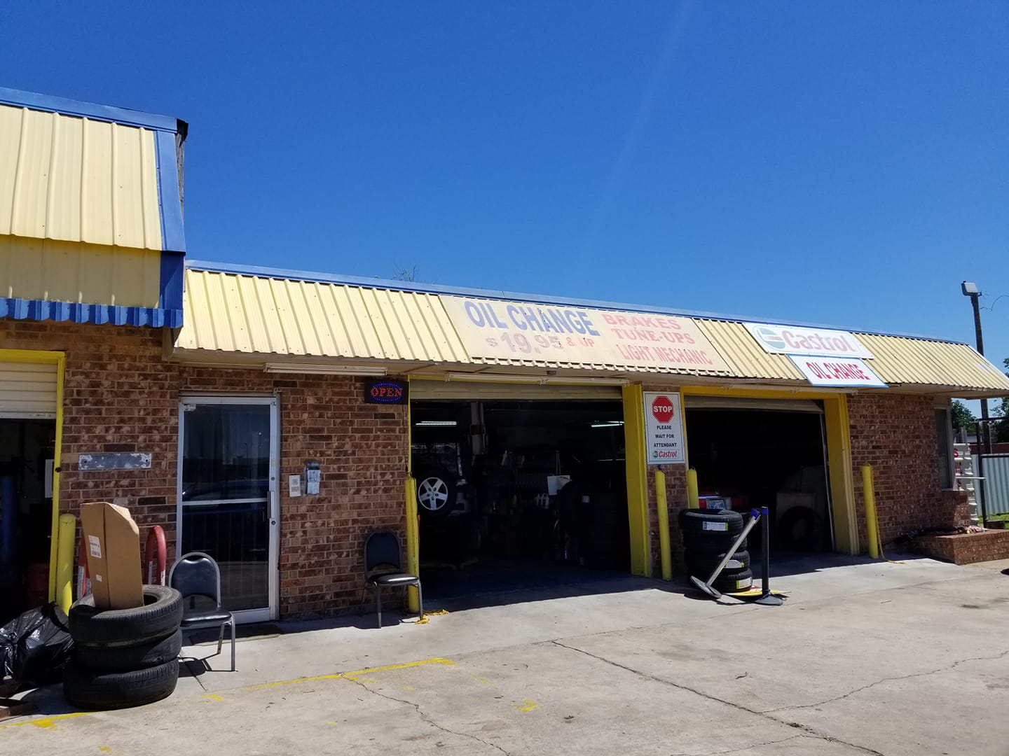
I highly recommend this auto shop for any storm chasers needing car service south of Oklahoma City. Its 44 AutoKare. Charges HALF the prices of Jiffy Lube and most importantly they are fast and HONEST!44 Auto Kare, 1101 SE 44th St, Oklahoma City, OK 73129
Posted: Jun 23, 2019, 8:27 PM
Chris Collura commented on a post.
Posted: Jun 23, 2019, 4:46 PM
Chris Collura commented on Van Perpetual Bloom's photo.
Oh no. Prayers.
Posted: Jun 23, 2019, 4:43 PM
Chris Collura commented on Colt Forney's post.
Its not you it's the atmosphere.
Posted: Jun 23, 2019, 2:43 PM
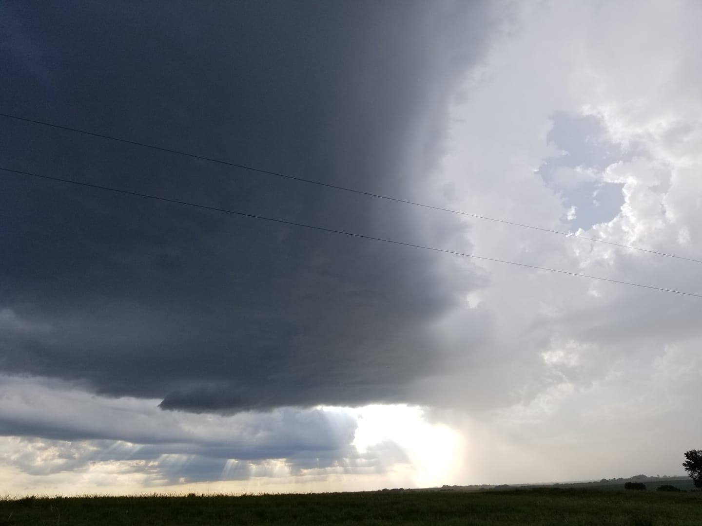
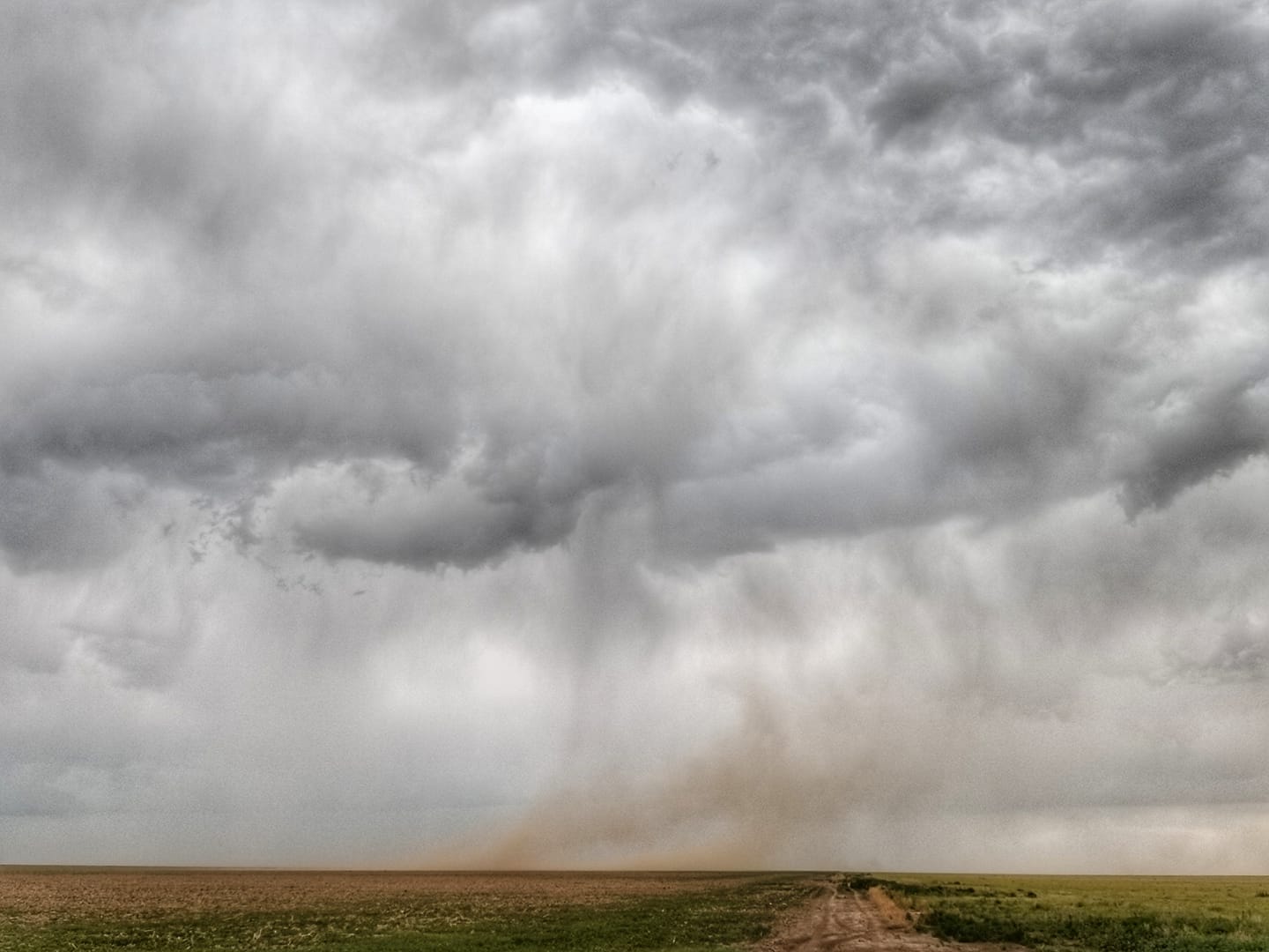
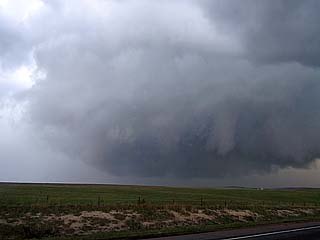
Probably the "storm of the day" near Scotland, Texas. Note "whales mouth" (underside of outflow / gust front) making for an interesting cloud base. June 23, 2019.
Posted: Jun 22, 2019, 5:15 PM
Chris Collura commented on Daniel Shaw's post.

Posted: Jun 22, 2019, 12:48 PM
Chris Collura replied to a comment.
Posted: Jun 22, 2019, 11:15 AM
Chris Collura commented on Colt Forney's post.
Where? Cant be everywhere!
Make sure you have spotter network running so we can avoid the garb-vection.
Posted: Jun 22, 2019, 11:10 AM
Chris Collura commented on Meteorologist Tony Laubach's post.
Good luck. I'm playing the tail end of the cold front near the OK panhandle. I was discouraged by the HRRR runs but who knows.
Posted: Jun 22, 2019, 9:29 AM
Chris Collura replied to Dave Lewison's comment.
Dave Lewison That's a good option for the rear and front. Better visibility too.
Posted: Jun 22, 2019, 9:25 AM
Chris Collura replied to Jock McGinty's comment.
Jock McGinty Thanks. It's in Sharon Springs in Wallace County Kansas. I'll put a note in the video.
Posted: Jun 22, 2019, 9:23 AM
Chris Collura replied to Dave Lewison's comment.
Dave Lewison Wasnt hail that actually broke the glass. It was pebbles and they got in between the 2" space between the spare tire and the guard. Completely horizontal and at 100 mph. Not designed for that. Plus all this after spending 20 minutes in a hail core of 2" and not a scratch :]
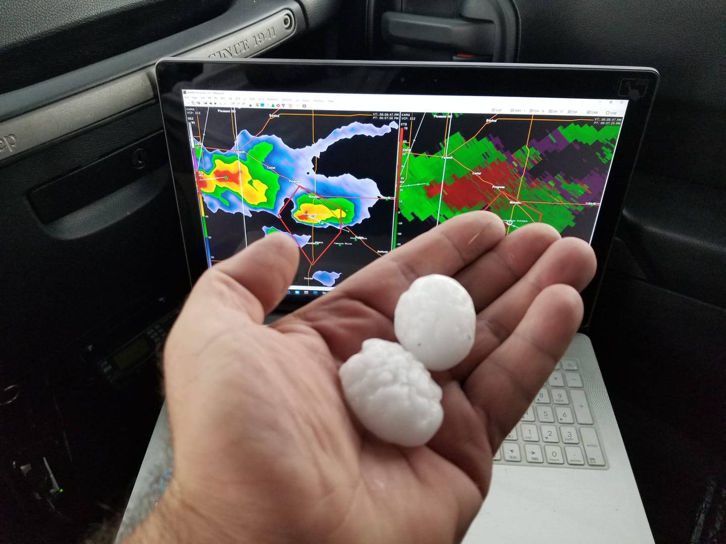
Posted: Jun 22, 2019, 12:45 AM
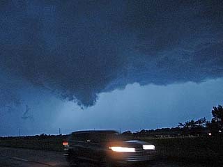
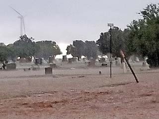
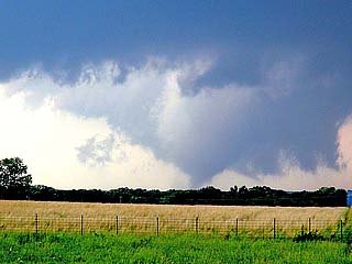
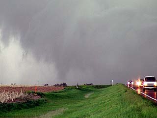
Crazt storm chasing day starting in Colorado with two tornadic supercells. Ended up having my back window smashed out as extreme winds blew into Sharon Springs, Kansas. Enjoy the short video!Note: In the video the location should be Sharon Springs, not Sheridan Lake.
Posted: Jun 21, 2019, 6:58 PM
Near Arapahoe, Colorado (June 21, 2019).
Posted: Jun 21, 2019, 10:39 AM
Chris Collura commented on Doug Kiesling Photo & Video Fan Page.'s post.
Two things I hate the most...
"You're not my type."
"Road work ahead."
Posted: Jun 21, 2019, 10:31 AM
Chris Collura commented on Daniel Shaw's post.
Jesus Daniel Shaw. You are a great guy. It's tough hearing about this. I will keep him in my prayers. God bless.
Posted: Jun 20, 2019, 9:55 PM
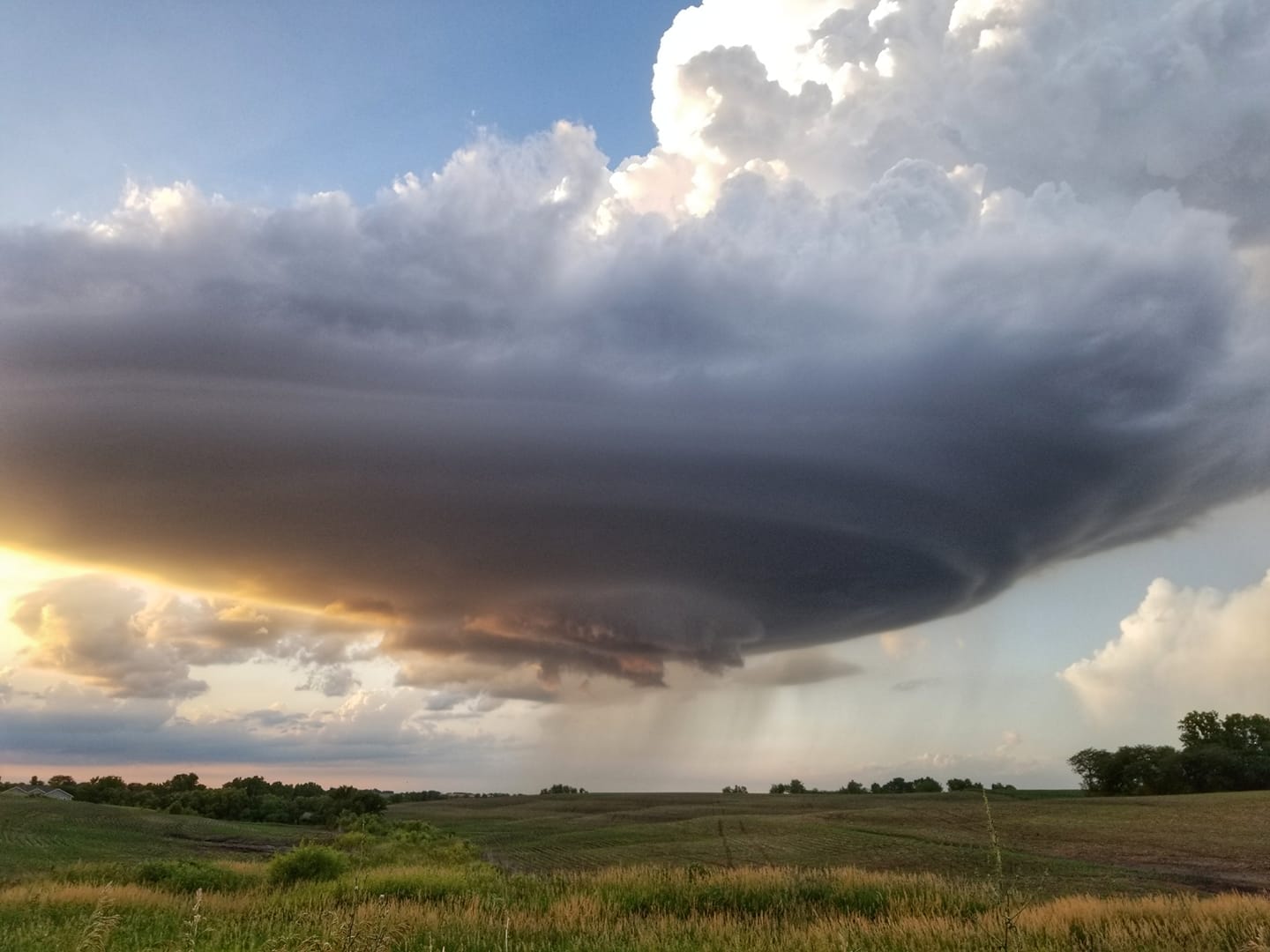
LP storm timelapse over NE Kansas. June 20, 2019.
Posted: Jun 20, 2019, 9:53 PM
Timelapse of LP storm earlier near Vermilion, Kansas (June 20, 2019).
Posted: Jun 20, 2019, 9:49 PM
Chris Collura replied to his own comment.

Posted: Jun 20, 2019, 7:06 PM
That's just nuts (Namaha County, Kansas) - June 20, 2019.
Posted: Jun 20, 2019, 6:01 PM
I'll take a gorgeous LP storm in north central Kansas any day! June 20, 2019.
Posted: Jun 20, 2019, 5:27 PM
Chris Collura commented on Daniel Shaw's post.
I only learned of this an hour or so ago. This is really upsetting.
Posted: Jun 20, 2019, 5:26 PM
Severe storm (isolated north of Vermilion, Kansas) on June 20, 2019.
Posted: Jun 20, 2019, 3:56 PM
Chris Collura commented on Severe Storm Interceptors's post.
Oh no!!!! Why???
Posted: Jun 20, 2019, 3:54 PM
Chris Collura commented on Greg Ansel's photo.
Glad you made it out there. I headed to Kansas City as Colorado was out of reach plus I wasnt planning on chasing today anyway after being in NE Texas yesterday. The KC area is capped solid anyway.
Posted: Jun 20, 2019, 3:52 PM
Chris Collura commented on a post.
Posted: Jun 20, 2019, 5:13 AM
Chris Collura commented on George Kourounis's photo.
Wow. I'd love to see the tracks of icebergs. Keep up the good work.
Posted: Jun 20, 2019, 5:11 AM
Chris Collura commented on Colt Forney's post.
And we were wondering WHY such a good looking storm died (???) ... Haha. Just kidding Colt Forney.
It would have died regardless of who's on it. Even if the Pope was there. Great shots BTW!
Posted: Jun 20, 2019, 5:09 AM
Chris Collura commented on a post.
Posted: Jun 19, 2019, 5:17 PM
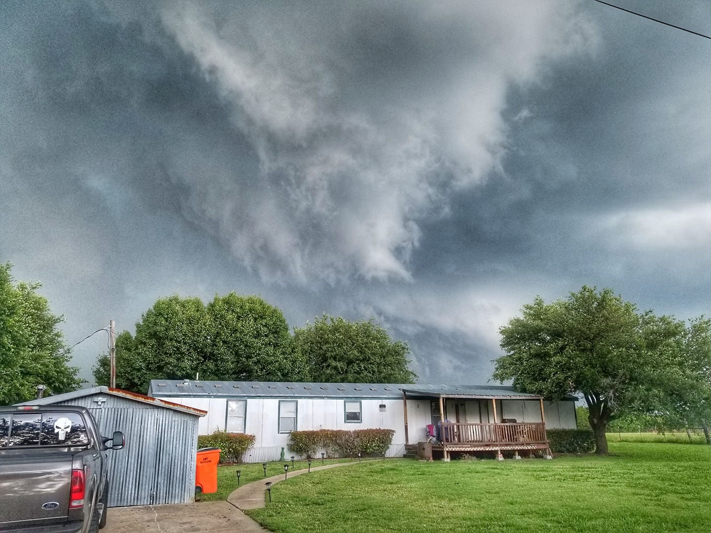
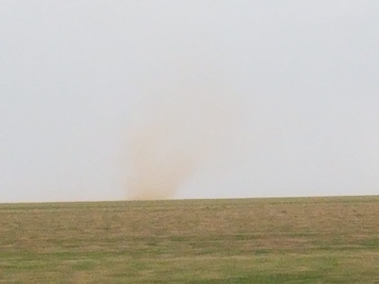
Want a tornado (or funnel at least)? Just be in a mobile home and Murphy will take care of it! June 19, 2019 west of Greenville, Texas.
Posted: Jun 19, 2019, 12:28 PM
Chris Collura commented on Jack Corso's photo.
The "outflow dominatrix" strikes again :]
Posted: Jun 19, 2019, 12:22 PM
Chris Collura replied to Jack Corso's comment.
Jack Corso haha. Florida ain't in any outlooks.
Posted: Jun 19, 2019, 12:21 PM
Chris Collura replied to Jack Corso's comment.
Posted: Jun 19, 2019, 12:20 PM
Chris Collura replied to Dave Lewison's comment.
Dave Lewison It was Shamu
Posted: Jun 19, 2019, 6:06 AM
Sometimes I wonder if the SPC folks have some artistic influence?
Posted: Jun 19, 2019, 4:40 AM
Chris Collura commented on The Ingressors's post.
Amazing stuff ... Thanks for sharing!
How long were these tunnels? Were they basically under the street going from one side to the other connecting basements?
Posted: Jun 18, 2019, 9:56 PM
Chris Collura commented on William T. Reid's post.
This was one of the days that put ones' forecasting skills to the test :)
Posted: Jun 18, 2019, 9:20 PM
Chris Collura commented on Lisa Beal's post.
I recited this every morning and we had to stand with our right hand on our hearts too!
Posted: Jun 18, 2019, 9:14 PM
Chris Collura replied to Tyler Schlitt's comment.
Tyler Schlitt Same here
Posted: Jun 18, 2019, 9:14 PM
Chris Collura commented on Brian Stertz's photo.
Was there an actual tornado report? Sometimes these high based storms can have hooks like that.
Posted: Jun 18, 2019, 8:06 PM
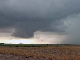
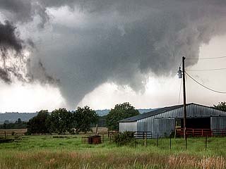
Chris Collura added a new photo.
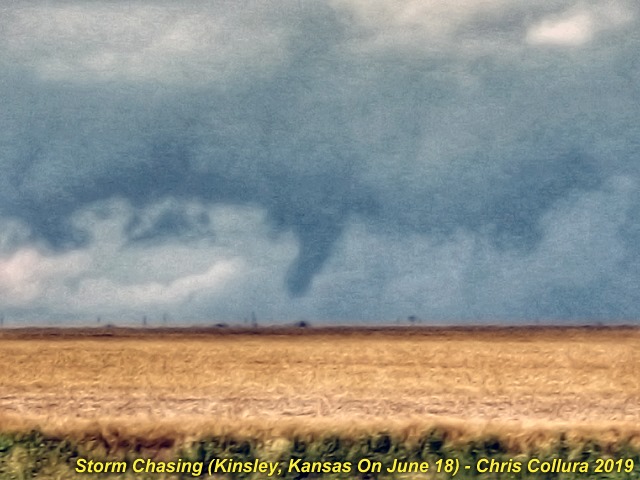
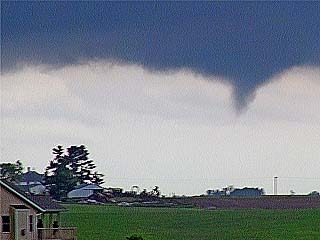
Brief tornado NW of Kinsley, Kansas during the afternoon of June 18 (at roughly 2:45 PM CDT). Starting to lift - Blink and you'll miss this one!
Posted: Jun 18, 2019, 8:06 PM
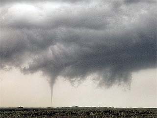
Chris Collura added a new photo.
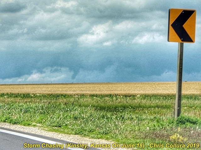
Brief tornado NW of Kinsley, Kansas during the afternoon of June 18 (at roughly 2:45 PM CDT). Closer view.
Posted: Jun 18, 2019, 8:06 PM
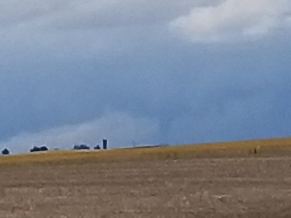
Chris Collura added a new photo.

Brief tornado NW of Kinsley, Kansas during the afternoon of June 18 (at roughly 2:45 PM CDT). Like a needle in a hay stack!
Posted: Jun 18, 2019, 6:09 PM
Chris Collura commented on Dave Lewison's photo.
Damn autocorrector.
Posted: Jun 18, 2019, 12:46 PM
Near Kinsley, Kansas (June 18. 2019).
Posted: Jun 18, 2019, 11:28 AM
Chris Collura replied to his own comment.
Posted: Jun 18, 2019, 10:16 AM
Chris Collura commented on a post.
Posted: Jun 18, 2019, 10:13 AM
Chris Collura commented on Daniel Shaw's post.
They JUST issued it 5 mins ago. Almost same as 13z as I make my way back into OK targeting Kansas.
Posted: Jun 18, 2019, 6:22 AM
Chris Collura commented on Lee Hegley's post.
Happy birthday!
Posted: Jun 18, 2019, 6:19 AM
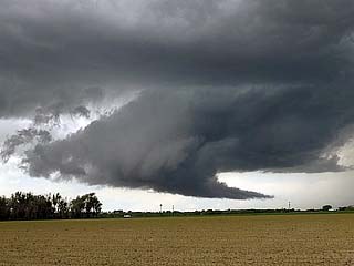
Chris Collura added a new photo.

View of the WP-3 Orion aircraft circling overhead with a powerful supercell in the background on June 16, 2019 near Abilene, Texas.
Posted: Jun 17, 2019, 9:48 PM
Chris Collura commented on Derek Sibley's photo.
I'm still out here chasing it.
Posted: Jun 17, 2019, 4:18 PM
Hail falling from LP storm near Muleshoe, Texas (June 17, 2019).
Posted: Jun 17, 2019, 3:50 PM
LP supercell near Muleshoe. Texas. June 17, 2019.
Posted: Jun 17, 2019, 2:35 PM
Chris Collura commented on Greg Ansel's photo.
Unfortunately I could not make this target and sticking west of AMA. Theres a even better storm north near Chivington with TVS!
Posted: Jun 17, 2019, 11:58 AM
Chris Collura commented on Ricky Forbes's photo.
Posted: Jun 17, 2019, 11:54 AM
Chris Collura commented on Daniela Fuentes's post.
Where is this?
Posted: Jun 17, 2019, 11:50 AM
Chris Collura commented on Miranda Kay Roberts's post.

Posted: Jun 17, 2019, 11:49 AM
Chris Collura commented on Stormtrack's post.
Clear my schedule and chase.
Posted: Jun 17, 2019, 11:47 AM
Chris Collura replied to a comment.
Posted: Jun 17, 2019, 11:46 AM
Chris Collura commented on a post.
Posted: Jun 16, 2019, 10:39 PM
Chris Collura commented on Daniel Shaw's post.
Well well ... I guess that explains why I am so shocked an epic video I post gets so few likes or comments :[
Posted: Jun 16, 2019, 5:02 PM
Learn what storm "upscale" and "downscale" growth is. Upscale is where a supercell storm evolves into a line segment and large storm cluster. But downscaling is when the storm just fades away. Watch a pretty nice LP supercell here on radar undergo such evolution :)
Posted: Jun 16, 2019, 4:14 PM
Northwest of Bangs, Texas on LP storm (June 16, 2019).
Posted: Jun 16, 2019, 3:18 PM
Nice mesocyclone (time lapse) near Coleman, Texas (June 16, 2019)...
Posted: Jun 16, 2019, 11:30 AM
Chris Collura replied to Jason Foster's comment.
Jason Foster Very similar only this was impinging fire.
Posted: Jun 16, 2019, 8:09 AM
Chris Collura commented on Dave Lewison's post.
DIY is always a priceless skill to have!
Posted: Jun 16, 2019, 6:20 AM
Chris Collura replied to Stephen Sponsler's comment.
Yup ... Thats it!
Posted: Jun 16, 2019, 6:19 AM
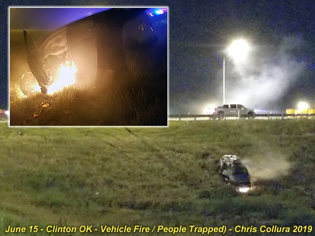
Last night (Saturday June 15, 2019) I came across a nearly deadly accident on the entrance ramp to I-40 westbound off Highway 183 in Clinton, Oklahoma. With tornado sirens blaring and 70+ MPH RFD winds with a confirmed large tornado to the north, I came across a pickup truck and mangled guard rail and a mangled car down the embankment. I stopped as I did not see anyone on the scene and the car had a fire in its front end. I ran down with another local to check and a women and two children were trapped in the vehicle and pinned. We called EMS and managed to smash the window (using my bare hands - ouch!) and try to get the doors open, as well as stomp and keep the fire getting to the driver and kids, barely conscious. There was not much we can do as the doors were just jammed. The police and fire department arrived within minutes as we kept trying to try to pry the doors and get the people out. EMS ran down and pryed the driver door, dragging her to safety, as well as the kids and right after that (the inset in the photo) the drivers side door was involved in the fire. The woman and kids appeared seriously injured (probably blunt trauma as the car rolled multiple times). Had it not been for the timely and professional services of our brave men with Clinton Police and Fire, I probably would have seen a young woman and her kids burn to death with me forced to helplessly watch (as well as the sounds of their screams haunting me forever). If you see any firefighter or EMS - Give them an hug and a big wet kiss too!
Posted: Jun 16, 2019, 12:23 AM
Chris Collura commented on Adri Mozeris's post.
Awesome work. That storm was a monster. Take that SPC with your '2% tor probs' ... Just kidding = Boundaries work wonders!
Posted: Jun 16, 2019, 12:21 AM
Chris Collura commented on Miranda Kay Roberts's post.
Oh nooooooo!!!!!
Posted: Jun 16, 2019, 12:17 AM
Chris Collura commented on Roger Edwards's photo.
And crazy wildflowers too!
Posted: Jun 16, 2019, 12:13 AM
Chris Collura commented on William T. Reid's photo.
Posted: Jun 15, 2019, 9:33 PM
Chris Collura commented on Colt Forney's photo.
Posted: Jun 15, 2019, 9:32 PM
Chris Collura commented on Colt Forney's photo.

Posted: Jun 15, 2019, 9:31 PM
Chris Collura commented on Daniel Shaw's photo.
This place was so cool. The sweet lady running the place even gave us the full walking tour!
Posted: Jun 15, 2019, 9:14 PM
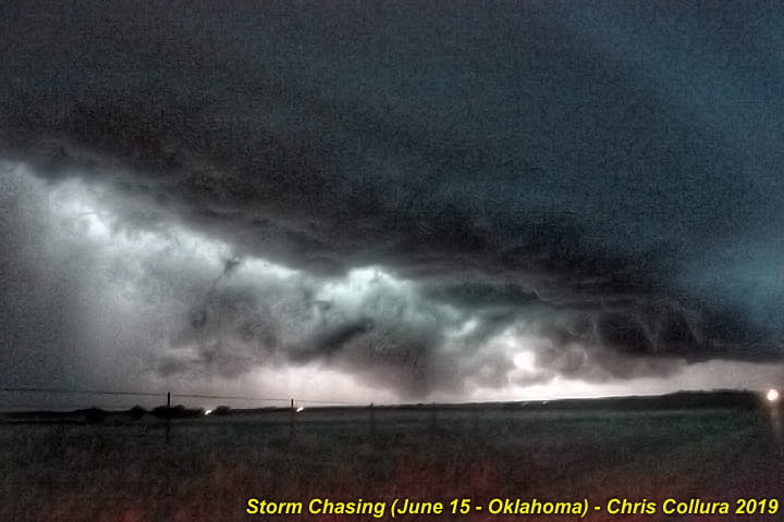
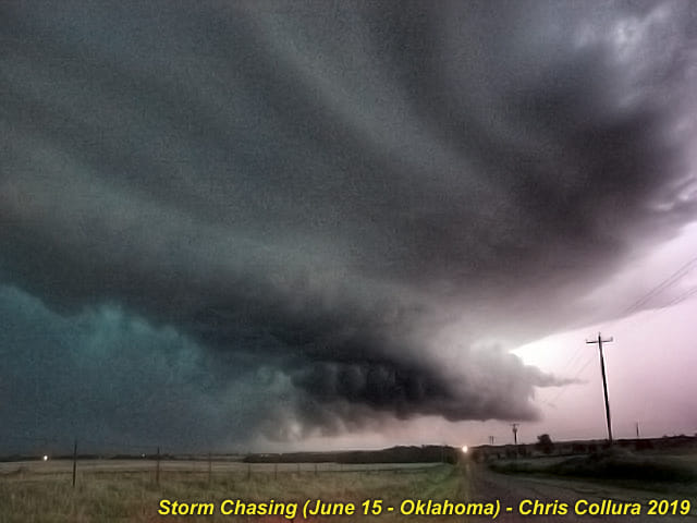
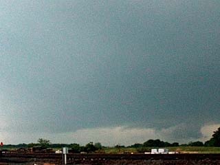
Chris Collura added a new photo.

Supercell storm north of Clinton, OK and SW of Fay just after dark on June 15, 2019.
Posted: Jun 15, 2019, 9:14 PM
Chris Collura added a new photo.
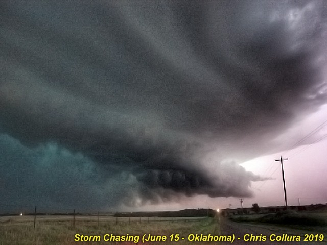
Supercell storm north of Clinton, OK and SW of Fay just after dark on June 15, 2019. Possible large tornado barely visible to the lower left!
Posted: Jun 15, 2019, 9:14 PM
Chris Collura added a new photo.

Supercell storm north of Clinton, OK and SW of Fay just after dark on June 15, 2019. Lightning illuminated. Possible large tornado visible to the lower left!
Posted: Jun 15, 2019, 9:14 PM
Chris Collura added a new photo.
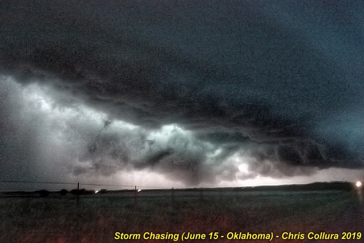
Supercell storm north of Clinton, OK and SW of Fay just after dark on June 15, 2019. Lightning illuminated. Possible large tornado visible to the lower left!
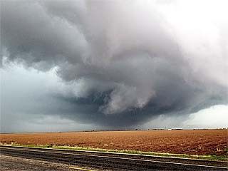
Posted: Jun 15, 2019, 9:10 PM
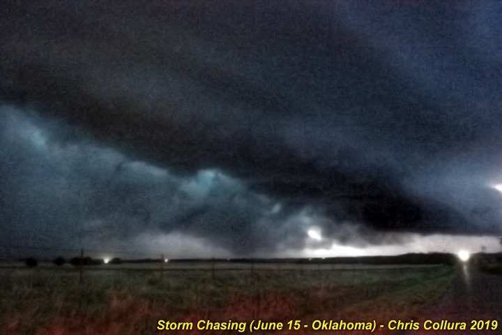
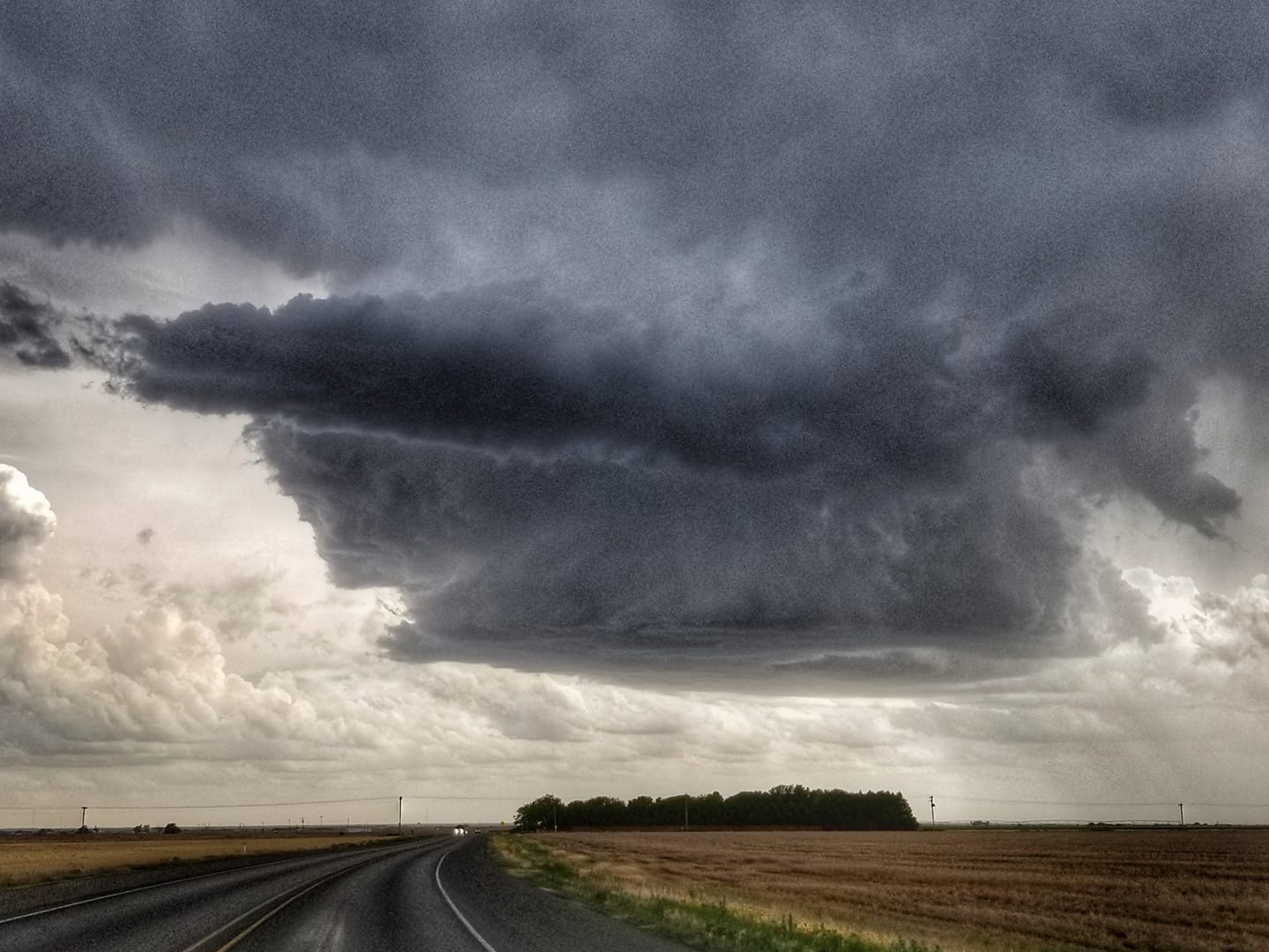
Oh those 2% days can always be interesting, ey? This was about 20 miles north of Clinton, Oklahoma on June 15, 2019 at dusk!
Posted: Jun 14, 2019, 4:58 PM
Chris Collura commented on Tim Marshall's post.
Posted: Jun 14, 2019, 4:57 PM
North of Manter, Kansas. High based mesocyclone and very warm RFD :)
Posted: Jun 13, 2019, 8:09 PM
Chris Collura commented on Stormtrack's post.
Posted: Jun 13, 2019, 7:55 PM
Chris Collura updated his status.
After some down time I'm heading back out for the mid to late June storm chase season. In Topeka, Kansas for the night after leaving Chicago area this afternoon. En route to SW Kansas tomorrow for starters.
Posted: Jun 13, 2019, 7:53 PM
Chris Collura commented on Tim Marshall's photo.
I'm heading out and should be out for tomorrows setup.
Posted: Jun 13, 2019, 9:12 AM
Chris Collura commented on George Kourounis's photo.
I'm curious, George, how much are the bag fees?
Posted: Jun 12, 2019, 9:09 PM
Chris Collura replied to his own comment.
Daniel Shaw Cool that's pretty much my last days out too before returning to "reality" :]
Posted: Jun 12, 2019, 6:49 PM
Chris Collura commented on Daniel Shaw's photo.
Daniel Shaw, how much longer will you be out in the Alley? I will be heading out again next week if weather "permits"!
Posted: Jun 12, 2019, 3:35 PM
Chris Collura replied to James G. Lea's comment.
Doug Kiesling Good.
Posted: Jun 12, 2019, 11:56 AM
Chris Collura commented on Miranda Kay Roberts's post.
Yeah as long as there is no baseball sized hail!
Posted: Jun 12, 2019, 11:45 AM
Chris Collura commented on a post.
Posted: Jun 12, 2019, 10:27 AM
Chris Collura commented on David Hoadley's photo.
Crazy chaser convergence!
Posted: Jun 12, 2019, 10:24 AM
Chris Collura replied to John Monteverdi's comment.
John Monteverdi Agreed. Plus not only are you going to be looked down on, but even posting something epic will get you almost no likes or comments ... Since this creates a bad reputation on here (from the personal drama). Its embarrassing too.
Posted: Jun 12, 2019, 10:23 AM
Chris Collura commented on Max Olson's post.
I'll take "sky drama" over "chaser drama" anytime!!!!
Posted: Jun 12, 2019, 8:03 AM
Chris Collura replied to his own comment.
Billy Wade Yeah many of those places are best kept secret otherwise they can be ruined.
Posted: Jun 12, 2019, 8:00 AM
Chris Collura commented on Billy Wade's post.
These bridges in middle America are inspiring and my favorites.
Unfortunately many are disappearing and being replaced with tensioned I beam concrete only looking like a road (meh)!
The iron work, riveting, cross bracing is just a whisper of the past industrial age and hard working blue collar workforces.
Posted: Jun 12, 2019, 7:55 AM
Chris Collura replied to James G. Lea's comment.
James G. Lea Hes still deep in the woodwork and crawles out of it once in a while.
Posted: Jun 12, 2019, 7:51 AM
Chris Collura commented on Dave Lewison's post.
AND a year or so ago I MYSELF was guilty of posting personal / family rants on here (sans the bad driving nor and bad chase tactics such as "going under an underpass in a tornado direct hit") LOL.
What I noticed is that (at least on here) this only tarnished what people thought of me on here. The last time I was going through a rough period late last year I just temporarily LEFT Facebook instead. Since then I refrain from posting any drama if it happens (sorry folks)!
I believe that such venting or ranting about personal things (family, being rejected by g/f, online dating fails, etc) only creates a toxic effect and can even create a "positive feedback" (rant about losing a friend or such, people on FB take it the wrong way, you lose them as friends too, round, and round)!
Posted: Jun 11, 2019, 8:02 PM
Chris Collura commented on Skip Talbot's post.
Great stuff, Skip Talbot! You guys had that storm by the ballz!
Posted: Jun 11, 2019, 7:43 PM
Chris Collura commented on John Beven's post.
Posted: Jun 11, 2019, 7:42 PM
Chris Collura commented on John Beven's post.

Posted: Jun 11, 2019, 7:37 PM
Chris Collura replied to his own comment.
Miranda Kay Roberts Haha.. loved that Song too (Blue by Eiifel)!
Posted: Jun 11, 2019, 7:18 PM
Chris Collura commented on David Hoadley's photo.

Posted: Jun 11, 2019, 6:57 PM
Chris Collura commented on Snoop Dogg's video.
I assume Laos or Thailand? Interesting trap.
Posted: Jun 11, 2019, 6:51 PM
Chris Collura replied to Anderson Serena's comment.
Anderson Serena Virgin America was bought out by Frontier. Total POS airline like Spirit. Found that out the hard way trying to redeem points in 2017.
Posted: Jun 11, 2019, 6:50 PM
Chris Collura commented on Virgin Australia's video.
Virgin America was awesome but they're gone. Virgin "whatever" :[
Posted: Jun 11, 2019, 6:43 PM
Chris Collura commented on John Beven's post.
Sounds like false scare tactics from someone watching way WAY too many disaster / horror films!
Posted: Jun 11, 2019, 6:40 PM
Chris Collura replied to James G. Lea's comment.
Doug Kiesling "Whore-Rod-En-Eur"
(Aka Horodener)
Posted: Jun 11, 2019, 6:38 PM
Chris Collura commented on Miranda Kay Roberts's post.
https://youtu.be/JgKPYf6jQ9I
Posted: Jun 11, 2019, 4:14 PM
Chris Collura replied to his own comment.
Posted: Jun 11, 2019, 4:11 PM
Chris Collura commented on a post.
Posted: Jun 11, 2019, 12:16 PM
Chris Collura commented on Science101's post.

Posted: Jun 11, 2019, 12:11 PM
Chris Collura commented on Science101's post.
These are "hole punch" clouds from descending air / precipitation at high altitude. They are harmless.
Posted: Jun 11, 2019, 12:08 PM
https://play.zooquizzes.com/outcome?data=JTdCJTIycmVkaXJlY3RfdXJsJTIyJTNBJTIyaHR0cHMlM0ElMkYlMkZwbGF5Lnpvb3F1aXp6ZXMuY29tJTJGcXVpeiUyRm9ubHktMS00Mi1wZW9wbGUtY2FuLWlkZW50aWZ5LXRoZXNlLW1pbGl0YXJ5LXBsYW5lcy1hLXBvcnRpb24tYS1waG90by1jYW4teW91JTNGYWRpZCUzRDIzODQzMzYzMjYwOTQwNTE3JTI2bWtjcGduJTNEZTRhZjM1MjY4NDRjNDIyNTg2YTAwZDY4MTMxYzdkZDElMjZwYXJlbnRfc291cmNlJTNEZmFjZWJvb2slMjZ1dG1fc291cmNlJTNEc2hhcmUtZmIlMjIlMkMlMjJ0aXRsZSUyMiUzQSUyMkklMjBnb3QlMjAzNiUyMG91dCUyMG9mJTIwNDAhQ2FuJTIwWW91JTIwSWRlbnRpZnklMjBUaGVzZSUyME1pbGl0YXJ5JTIwUGxhbmVzJTIwRnJvbSUyMGElMjBQb3J0aW9uJTIwb2YlMjBhJTIwUGhvdG8lM0YlMjIlMkMlMjJkZXNjcmlwdGlvbiUyMiUzQSUyMkNoYWxsZW5nZSUyMHlvdXIlMjBmcmllbmRzJTIwd2l0aCUyMHRoaXMlMjBxdWl6ISUyMiUyQyUyMmltYWdlJTIyJTNBJTIyaHR0cHMlM0ElMkYlMkZjZG4ubm93Lmhvd3N0dWZmd29ya3MuY29tJTJGbWVkaWEtY29udGVudCUyRjUxYjQ4ZGNjLTZmNWMtNGU5OC1iODVkLWVhZDNhMmNhMTQ3ZS02NDAtMzYwLmpwZyUyMiU3RA%3D%3D
Posted: Jun 11, 2019, 11:56 AM
Chris Collura replied to a comment.
Posted: Jun 11, 2019, 11:50 AM
Chris Collura replied to Barrett Stejskal's comment.
Posted: Jun 11, 2019, 10:16 AM
https://youtu.be/AdPZf-rbUNE
Posted: Jun 10, 2019, 8:02 PM
Chris Collura commented on Jennifer Brindley Ubl's post.
This is awesome and I'm happy to see you and your team get such great data ... plus being ON THAT STORM and ON TIME!
Posted: Jun 9, 2019, 9:09 PM
Chris Collura commented on Daniel Shaw's post.
Awesome! Thanks for sharing this!
Posted: Jun 9, 2019, 11:21 AM
Chris Collura commented on Brian Stertz's photo.
Ridge or winter = cat pics :)))
Happy Birthday anyway!
Posted: Jun 9, 2019, 11:20 AM
Chris Collura commented on Brian Stertz's post.
When it's the OFF season ... The cat pics.
Posted: Jun 9, 2019, 11:19 AM
Chris Collura commented on Matt Sellers's photo.
That's depressing. Like May 2003 and "you should have been here last week" :(
Posted: Jun 9, 2019, 11:18 AM
Chris Collura commented on Mike Olbinski Photography's photo.
This post blocked attaching pictures? Why? Screw FB!!!!!!!!!!!
Posted: Jun 9, 2019, 11:17 AM
Chris Collura commented on Mike Olbinski Photography's photo.
http://sky-chaser.com/image/mwcl2019/m20tor23.jpg
Posted: Jun 9, 2019, 11:11 AM
Chris Collura commented on Severe Storm Interceptors's video.
This is so cool. A little "piece" of May 28, 2018 in Seibert CO. That stretched vorticity can be quite interesting.
Posted: Jun 8, 2019, 7:26 PM
Chris Collura replied to Scott Weberpal's comment.
Scott Weberpal Yes. I'm sure he saw his shot of hurricane Michael's eye and lost it.
Posted: Jun 8, 2019, 7:23 PM
Chris Collura replied to his own comment.
David Gold Landspouts ... I'll take those :)
Posted: Jun 8, 2019, 7:14 PM
Chris Collura commented on Doug Kiesling's post.
Someones mad about the ridge on the GFS and blowing smoke out of their ass... lol
Posted: Jun 8, 2019, 7:54 AM
Chris Collura commented on Alina Suarez Sherman's post.
Awesome! You folks still have a skydive drop zone there?
Posted: Jun 8, 2019, 7:52 AM
Chris Collura commented on a post.
Posted: Jun 8, 2019, 7:49 AM
Chris Collura replied to Chris Gullikson's comment.
I think May 17, 2019 was a great "do-over"!
Posted: Jun 8, 2019, 7:47 AM
Chris Collura commented on his own photo.
Probably done chasing. If something happens in mid-late June, fine. If not no big deal. I have a place to stay in Chicago with family until early July then go back to Californaia. May was awesome. I cringe thinking about being on a chase-cation / tour now - Hearing "You guy's should have been here in late May!"
Posted: Jun 8, 2019, 5:41 AM
Is it JUNE or JANUARY?Looks like basically NO JUNE this season for chasing (at least in the 4 to 8 day near term)!Yuck...
Posted: Jun 7, 2019, 8:30 PM
Chris Collura replied to his own comment.
Doug Kiesling I figured that. Kinda happy there's a ridge now to reduce this non sense.
Posted: Jun 7, 2019, 8:23 PM
Chris Collura replied to his own comment.
Thomas Hinterdorfer This actually caused me to get a 20 piece this afternoon! Thanks.
Posted: Jun 7, 2019, 8:21 PM
Chris Collura commented on Doug Kiesling's photo.
Jesus. Daniel Shaw has a content user's group for this.
Posted: Jun 7, 2019, 4:19 PM
Chris Collura commented on Miranda Kay Roberts's post.
We Like to Party (Vengaboys song)
Posted: Jun 7, 2019, 4:11 PM
Chris Collura commented on Thomas Hinterdorfer's photo.
Is that a standard shift?
I see nuggets flying!
Posted: Jun 7, 2019, 1:13 PM
Chris Collura commented on Ericka Gray's post.
Posted: Jun 7, 2019, 1:09 PM
Chris Collura commented on The NOAA Hurricane Hunters's post.

Posted: Jun 7, 2019, 12:58 PM
Chris Collura replied to his own comment.
The NOAA Hurricane Hunters Nice! Keep up the good work and thanks for your service!
Posted: Jun 7, 2019, 11:24 AM
Chris Collura commented on The NOAA Hurricane Hunters's post.
Phased array? Looks different than the previous elliptical dish.
Posted: Jun 7, 2019, 11:20 AM
Chris Collura commented on Mark Robinson's photo.
Driving AWAY from it and not TOWARDS it?
Posted: Jun 7, 2019, 11:16 AM
Chris Collura replied to Shannon Prentice's comment.
George Kourounis British Columbia?
Posted: Jun 7, 2019, 7:36 AM
Chris Collura commented on George Kourounis's photo.
Iceland? Greenland?
Posted: Jun 7, 2019, 7:36 AM
Chris Collura commented on George Kourounis's photo.
Antarctica?
Posted: Jun 7, 2019, 7:34 AM
Chris Collura commented on Jack Corso's post.

Posted: Jun 7, 2019, 7:32 AM
Chris Collura commented on Jack Corso's post.
Posted: Jun 6, 2019, 3:03 PM
Chris Collura commented on Max Olson's photo.
AND ... LOOKING in the viewfinder to see "Rec" in red text, and not "STBY" in green.
Posted: Jun 6, 2019, 3:01 PM
Chris Collura replied to his own comment.
Rocky Rascovich Hope so...
Posted: Jun 6, 2019, 3:00 PM
Chris Collura commented on Dave Lewison's photo.
Good choice. Certainly no storms being MISSED now.
Enjoy your birthday!!!!
Posted: Jun 6, 2019, 2:58 PM
Chris Collura commented on David Gold's photo.
Quiet (but rainy) pattern, David Gold.
Posted: Jun 6, 2019, 2:55 PM
Chris Collura commented on Rocky Rascovich's photo.
A long LONG loooooeeeennng period of no chaseable storms begins :)))
Posted: Jun 6, 2019, 11:34 AM
Chris Collura replied to Jesus Olivares's comment.
Dagmar Kress Negative 3 or 4 was bad enough. This can cause a stroke in her case.
Posted: Jun 6, 2019, 11:32 AM
Chris Collura commented on ABC15 Arizona's video.
Probably negative 9 Gs in her head = Stroke. How on earth would they let that litter spin like that???
Posted: Jun 6, 2019, 11:22 AM
Chris Collura commented on Drivepedia's post.
That's amazing. These beautiful creatures are so gentle and protective and very intelligent. One of my favorite animals. Thanks for sharing!
Posted: Jun 6, 2019, 11:09 AM
Chris Collura commented on Mike Goulian's video.
That's what 50,000 horsepower looks like :)
Posted: Jun 6, 2019, 11:08 AM
Chris Collura commented on Mike Goulian's video.
If I was skydiving from 14000 feet I wouldn't even have time to buckle by helmet before I have to jump!
Posted: Jun 6, 2019, 9:41 AM
Chris Collura commented on Doug Kiesling's post.
The USA can do all it wants and all its might to be clean and go green ... But the REST of the world will still cause 99% of climate change and destruction to our environment. Sucks.
Posted: Jun 6, 2019, 7:13 AM
Chris Collura commented on National Trust for Historic Preservation's post.
I love these beautiful bridges and hope many more of them are preserved!
Posted: Jun 6, 2019, 7:11 AM
Chris Collura replied to Robert Fitzgerald's comment.
Ofcourse. I thought this was tornado footage at first!
Posted: Jun 5, 2019, 8:08 PM
Chris Collura commented on ABC News's video.
Touching ... BUT there's also a tornado over his shoulder.
Posted: Jun 5, 2019, 6:41 PM
Chris Collura replied to his own comment.
Posted: Jun 5, 2019, 6:38 PM
Chris Collura commented on Doug Kiesling's post.
Great stuff!
Posted: Jun 5, 2019, 5:55 PM
Chris Collura commented on a post.
Posted: Jun 5, 2019, 10:58 AM
Chris Collura replied to Dave Lewison's comment.
Dave Lewison The dreaded HBV (Hudson Bay Vortex) is showing up on some runs and others it's not. Hopefully it wont verify. Glad I got out there when I did.
Posted: Jun 5, 2019, 9:54 AM
Chris Collura replied to Mark G. Farmer's comment.
Mark G. Farmer Well after 120 hours out its looking somewhat OK with a general trough approaching. But farther out it can be anything.
Posted: Jun 5, 2019, 9:39 AM
Chris Collura commented on Miranda Kay Roberts's post.
Very Asian :)
Posted: Jun 5, 2019, 9:35 AM
Chris Collura updated his status.
As it looks now a more substantial wave of severe weather appears likely as of June 10 and beyond for the central and high plains.
Lately setups have been marginal with rain and wind the biggest threats (outside of some storms in NM).
I have been sitting out the last setups since May 30 and hope to get out there again for mid June if these ling range models verify.
Posted: Jun 5, 2019, 9:08 AM
Chris Collura posted in 2019 CSC Independence Boogie.
This sounds great as I have a good chance of attending. Keep us updated on the aircraft line up too!
Posted: Jun 5, 2019, 8:18 AM
Chris Collura commented on Max Olson's post.
I absolutely LOVE this collection!
Posted: Jun 5, 2019, 8:15 AM
Chris Collura replied to his own comment.
Max Olson Beautiful stuff! Thanks.
Posted: Jun 5, 2019, 7:44 AM
Chris Collura commented on Max Olson's photo.
When was this? Yesterday in NM? Or is this the Simla storm in CO on June 4, 2015?
Posted: Jun 5, 2019, 7:03 AM
Chris Collura commented on Miranda Kay Roberts's post.
WTF? Why didnt they just pick it up and put it in a container truck? This is worse than just leaving it there. Disgusting.
Posted: Jun 4, 2019, 4:50 PM
Chris Collura commented on Miranda Kay Roberts's post.
Open Water
Posted: Jun 4, 2019, 8:16 AM
Chris Collura commented on Miranda Kay Roberts's post.
https://youtu.be/E6GsXhBb10k
Posted: Jun 3, 2019, 2:56 PM
Chris Collura commented on Daniel Shaw's post.
Ouch!
Posted: Jun 3, 2019, 2:42 PM
Chris Collura commented on a post.
Posted: Jun 3, 2019, 2:41 PM
Chris Collura commented on Daniel Shaw's photo.
Posted: Jun 3, 2019, 2:39 PM
Chris Collura replied to Jasen Collins's comment.
Posted: Jun 3, 2019, 2:37 PM
Chris Collura replied to Russell Henderson's comment.
Posted: Jun 3, 2019, 2:37 PM
Chris Collura replied to Robin Graham's comment.
Posted: Jun 3, 2019, 2:36 PM
Chris Collura replied to Alan Broerse's comment.
Posted: Jun 3, 2019, 2:34 PM
Chris Collura replied to a comment.
Posted: Jun 3, 2019, 2:32 PM
Chris Collura commented on Doug Kiesling's post.
"We sincerely apologize for any inconvenience this may have caused..." lol
Posted: Jun 3, 2019, 2:08 PM
https://youtu.be/USwScMLv82o
Posted: Jun 3, 2019, 11:33 AM
Chris Collura added a new photo.
Base of a cluster / line of strong to severe storms west of Pampa, Texas during the afternoon of May 23. These were highly outflow dominant at this time (with cold outflow), however, part of this line segment will go on to produce a wedge tornado near Canadian later on.Place: Borger, Texas (35.662777777778, -101.40166666667) Address: Borger, Texas 79007
Posted: Jun 3, 2019, 11:33 AM
Chris Collura added a new photo.
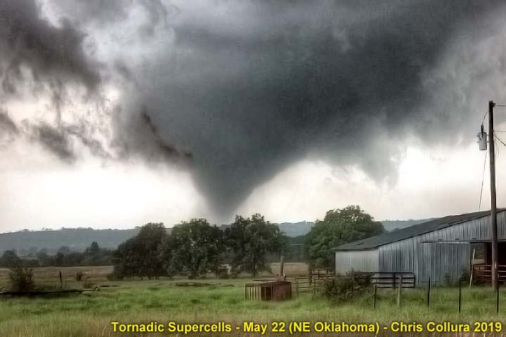
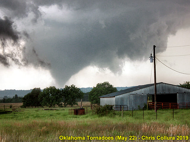
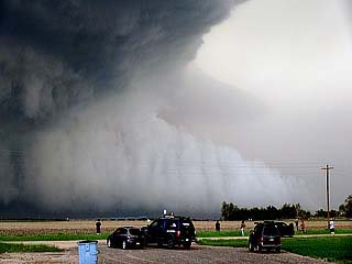
In this picture, a beautiful but strong tornado looms over an Oklahoma ranch near Wilson / Okmulgee looking westward late in the afternoon of May 22, 2019. On this same day, devastating tornadoes affected areas northeastward into Missouri in Jefferson City after dark. Storm chasing these incredible storms required deep respect for them, as well as being sensitive for anyone affected.
Posted: Jun 3, 2019, 11:33 AM
Chris Collura added a new photo.
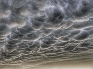
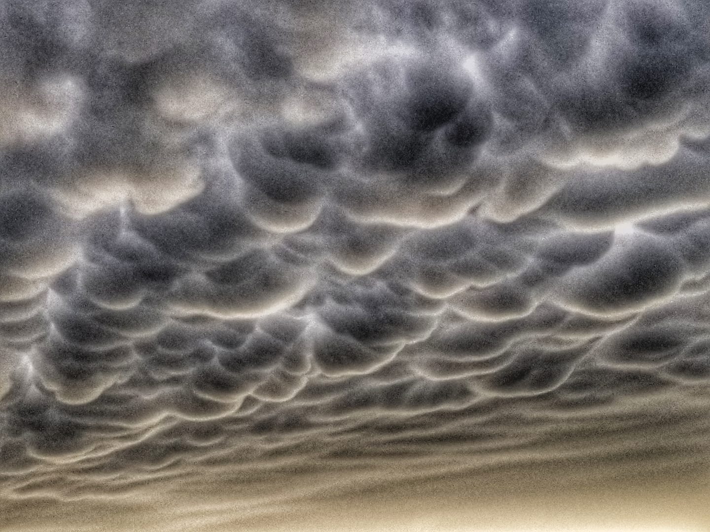
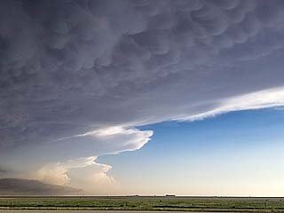
Closer view of the mammatus clouds near sunset on May 25 over the Texas Panhandle.
Posted: Jun 3, 2019, 11:33 AM
Chris Collura added a new photo.
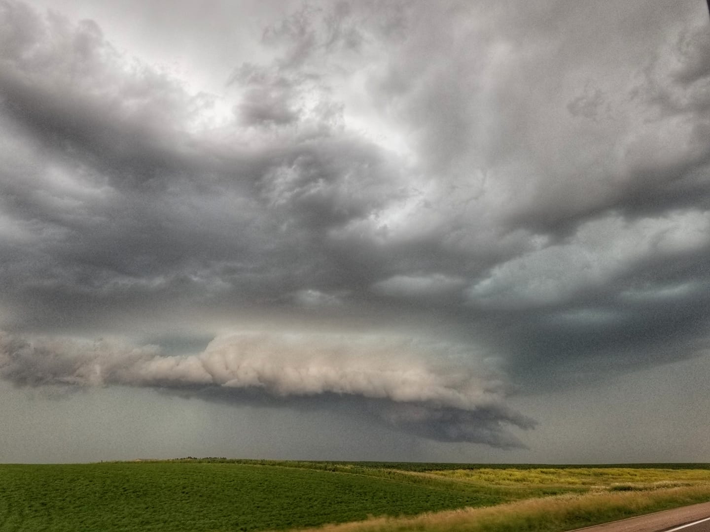
The storms near Hollis, Oklahoma later in the day became an active squall line and messy MCS (instead of the feared cluster of violent tornadic supercells). This shelf cloud and strong outflow denotes the chase day of May 20 is pretty much over.Place: Ron, Oklahoma (34.7922, -99.8594) Address: Ron, Oklahoma
Posted: Jun 3, 2019, 11:33 AM
Chris Collura added a new photo.

Mammatus clouds on the back side of the storm complex late in the day of May 25 over the Texas Panhandle.Place: Groom, Texas (35.2031, -101.107) Address: Groom, Texas 79039
Posted: Jun 3, 2019, 11:33 AM
Chris Collura added a new photo.

Convective initiation along a cold-occluded front / confluence line east of a surface low west of Iowa City and east of Des Moines, Iowa during the afternoon of May 29. The view is to the east along I-80.Place: Grinnell, Iowa (41.7438, -92.7247) Address: Grinnell, Iowa 50112, 50177
Posted: Jun 3, 2019, 11:33 AM
Chris Collura added a new photo.
With the storms near Fort Morgan becoming linear and outflow, the new target area is near Yuma, Colorado. Here a developing storm complex, albeit low topped and high based, can be seen looking southeast. This will evolve into an incredible supercell storm as it moves east over NE Colorado and eventually into Nebraska later on May 27.Place: Akron, Colorado (40.16139, -103.21167) Address: Akron, Colorado 80720
Posted: Jun 3, 2019, 11:33 AM
Chris Collura added a new photo.
Initiation of strong and severe thunderstorms along the occluded front / confluence line east of the surface low over north-central Kansas on May 21.Place: Burrton, Kansas (38.0225, -97.6722) Address: Burrton, Kansas 67020
Posted: Jun 3, 2019, 11:33 AM
Chris Collura added a new photo.
May 30 was a travel day, with a drive from Iowa City to Chicago for down time. In this image, a small (non-severe) convective shower hangs over Aurora, IL during the early afternoon os May 30, 2019.Place: Waterman, Illinois (41.7708, -88.7747) Address: Waterman, Illinois 60556
Posted: Jun 3, 2019, 11:33 AM
Chris Collura added a new photo.

Eerie hail fog near Petersburg, Texas after dark with large hail laying in the road just behind the supercells northeast of Lubbock on May 23.Place: Petersburg, Texas (33.8694, -101.598) Address: Petersburg, Texas 79250
Posted: Jun 3, 2019, 11:33 AM
Chris Collura added a new photo.

One of many storms that rapidly developed early in the afternoon of May 25. This messy storm complex is south and west of Canadian, Texas.Place: Stinnett, Texas (35.8261, -101.444) Address: Stinnett, Texas 79083
Posted: Jun 3, 2019, 11:33 AM
Chris Collura added a new photo.
View of developing towering cumulus and cumulonimbus clouds to the west of Pampa, Texas during the afternoon on May 23.Place: Panhandle, Texas (35.3475, -101.382) Address: Panhandle, Texas 79068
Posted: Jun 3, 2019, 11:33 AM
Chris Collura added a new photo.
Looking westward from west of Goodland, Kansas at an approaching MCS of strong and severe storms during the early evening of May 26. An eerie green tint to the sky looms over I-70 as hail present in the storm core filters out green light late in the day.Place: Ruleton, Kansas (39.3394, -101.889) Address: Ruleton, Kansas
Posted: Jun 3, 2019, 11:33 AM
Chris Collura added a new photo.

Base reflectivity image of the main and powerful supercell moving out of northeast Colorado during the afternoon of May 27, and near Imperial, Nebraska. The inset shows the Doppler velocity of the storm, which was producing tornadoes and sporting a striking visual appearance at the time.
Posted: Jun 3, 2019, 11:33 AM
Chris Collura added a new photo.
Mild rotation of the developing supercell near McPherson, Kansas during the afternoon of May 21.Place: Moundridge, Kansas (38.2025, -97.5186) Address: Moundridge, Kansas 67107
Posted: Jun 3, 2019, 11:33 AM
Chris Collura added a new photo.
View of the navigation software and tracking showing how difficult it was to find a way back across the Red River. The original supercell can be considered "lost" at this point!Place: Loco, Texas (34.7175, -100.152) Address: Loco, Texas
Posted: Jun 3, 2019, 11:33 AM
Chris Collura added a new photo.
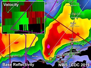
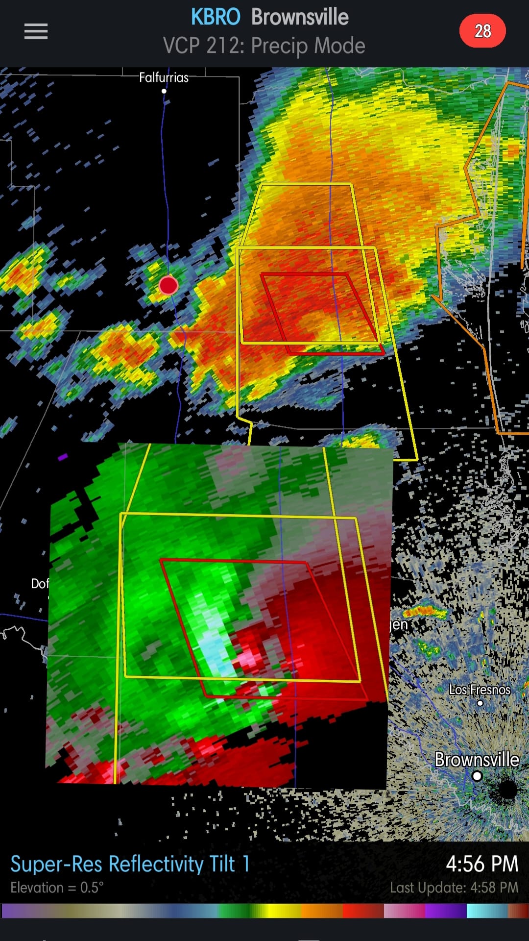
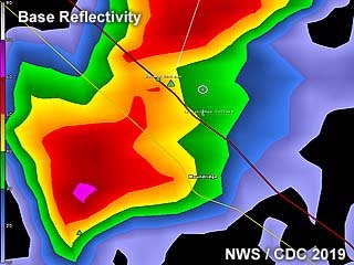
Radar image (base reflectivity) of a tornadic supercell developing near Paducah, Texas during the early afternoon of May 20. The inset shows the Doppler velocity of the developing tornado.
Posted: Jun 3, 2019, 11:33 AM
Chris Collura added a new photo.
Base reflectivity radar image of a developing tornadic supercell near McPherson, Kansas during the afternoon of May 21.
Posted: Jun 3, 2019, 11:33 AM
Chris Collura added a new photo.

Radar image (base reflectivity) of the tornadic supercell developing northwest of Henryetta and near Okmulgee, Oklahoma during the afternoon of May 22. The inset shows the Doppler velocity of the tornado region of the supercell storm
Posted: Jun 3, 2019, 11:33 AM
Chris Collura added a new photo.

Radar image (base reflectivity) of the supercell storms near Lubbock, Texas on May 23. The Doppler velocity image is in the inset, showing the broad rotation of the storm.
Posted: Jun 3, 2019, 11:33 AM
Chris Collura added a new photo.

Radar image (base reflectivity) of a supercell storm near Cap Rock, Texas on May 24. The Doppler velocity image is in the inset, showing the broad rotation of the storm, just before merging with a cluster of storms.
Posted: Jun 3, 2019, 11:33 AM
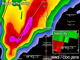
Chris Collura added a new photo.

Supercell storm base reflectivity image near Hall County, Texas during the early evening of May 25. The inset shows the Doppler velocity of this highly rain-wrapped mesocyclone.
Posted: Jun 3, 2019, 11:33 AM
Chris Collura added a new photo.
This is a base reflectivity image of a supercell north of Lamar, Colorado during the afternoon of May 26. The inset shows the Doppler velocity of the storm. This produced a very brief and weak tornado near Wiley.
Posted: Jun 3, 2019, 11:33 AM
Chris Collura added a new photo.

View of a funnel and possible tornado as the storm occludes near Pryor, Oklahoma after dark on May 22. The view is to the southeast.Place: Pryor, Oklahoma (36.30696, -95.31378) Address: Pryor, Oklahoma
Posted: Jun 3, 2019, 11:33 AM
Chris Collura added a new photo.
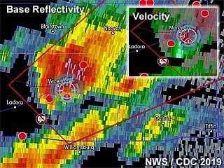
Base reflectivity image of Tipton / Beloit, Kansas supercell during the afternoon of May 28. The inset shows the Doppler velocity of the storm.
Posted: Jun 3, 2019, 11:33 AM
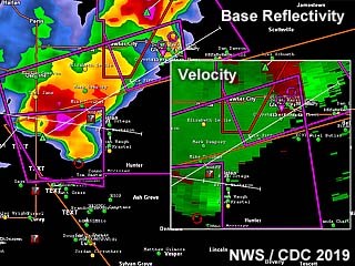
Chris Collura added a new photo.
Base reflectivity image of the Kansas City / Lawrence, Kansas supercell during the afternoon of May 28. Note the prominent "swirl" in the reflectivity, denoting a highly rain-wrapped HP supercell tornado. To the right are two insets, with the distinct correlation-coefficient showing debris (blue) to the top, as well as extreme Doppler velocities on the bottom inset.
Posted: Jun 3, 2019, 11:33 AM
Chris Collura added a new photo.

View of intense rotation of the supercell storm as it formed near Lamar and is moving northeast near Cheyenne Wells, Colorado late in the day on May 26 and looking east. This was very close to producing a tornado, but failed due to more stable air to the east of the storm.
Posted: Jun 3, 2019, 11:33 AM
Chris Collura added a new photo.
View of a funnel west of Chouteau, and towards Pryor, Oklahoma after dark on May 22. The view is to the northwest.Place: Chouteau, Oklahoma (36.187, -95.3383) Address: Chouteau, Oklahoma 74337
Posted: Jun 3, 2019, 11:33 AM
Chris Collura added a new photo.

View looking west towards the dryline north of Plainview, Texas late in the day on May 24.Place: Lider, Texas (34.1758, -101.624) Address: Lider, Texas
Posted: Jun 3, 2019, 11:33 AM
Chris Collura added a new photo.
Weakening supercell storm with funnel and RFD clear slot late in the day on May 21 north of Marquette, Kansas.
Posted: Jun 3, 2019, 11:33 AM
Chris Collura added a new photo.
Initial supercell storm with a small wall cloud developing in the early afternoon just south of Lubbock, Texas on May 24.
Posted: Jun 3, 2019, 11:33 AM
Chris Collura added a new photo.
View of the wall cloud of another supercell farther north near Chouteau, Oklahoma near dusk on May 22.
Posted: Jun 3, 2019, 11:33 AM
Chris Collura added a new photo.
Wall cloud forming on a supercell storm near Brush and Fort Morgan, Colorado during the afternoon of May 27.Place: Log Lane Village, Colorado (40.2708, -103.827) Address: Log Lane Village, Colorado 80705
Posted: Jun 3, 2019, 11:33 AM
Chris Collura added a new photo.

Wall cloud / rotating area of the supercell storm north of Lamar, Colorado during the afternoon of May 26.Place: Wiley, Colorado (38.155, -102.719) Address: Wiley, Colorado 81092
Posted: Jun 3, 2019, 11:33 AM
Chris Collura added a new photo.
Rotating wall cloud with RFD slot of a supercell evolving to an MCS / bow as it becomes outflow dominant east of Lubbock, Texas during the early afternoon of May 24.
Posted: Jun 3, 2019, 11:33 AM
Chris Collura added a new photo.
Wall cloud and supercell structure of a short-lived supercell storm west of Cap Rock, Texas before being undercut by surging outflow from storms to the NW on May 24.
Posted: Jun 3, 2019, 11:33 AM
Chris Collura added a new photo.
View of the wall cloud prior to tornado-genesis near Wilson, Oklahoma on May 22. The view is to the west.
Posted: Jun 3, 2019, 11:33 AM
Chris Collura added a new photo.
Wall cloud of a supercell storm late in the day on May 21 north of Marquette, Kansas.Place: Marquette, Kansas (38.55361, -97.83306) Address: Marquette, Kansas 67464
Posted: Jun 3, 2019, 11:33 AM
Chris Collura added a new photo.

Small weather balloon and probe rising rapidly into the supercell updraft after release by members of the TORUS group late on May 27 and west of Imperial, Nebraska.Place: Lamar, Nebraska (40.57247, -101.97847) Address: Lamar, Nebraska 69023
Posted: Jun 3, 2019, 11:33 AM
Chris Collura added a new photo.
May 19 was an off day and with a reposition back to Amarillo, Texas anticipating more storms for another active week. In this picture, at the Big Texan Steakhouse I am enjoying a great dinner with storm chasers. Here is Chris Kridler and Scott McPartland to name a few.Place: Amarillo, Texas (35.1993, -101.845) Address: Amarillo, Texas 79101
Posted: Jun 3, 2019, 11:33 AM
Chris Collura added a new photo.
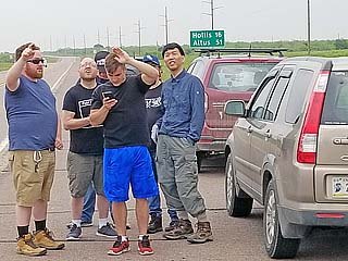
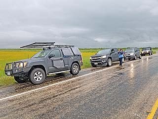
Group of storm chasers (one of many such groups) on the side of the road west of Hollis, Oklahoma in Texas near Highway 62 on May 20, waiting for convective initiation.Place: Loco, Texas (34.7175, -100.152) Address: Loco, Texas
Posted: Jun 3, 2019, 11:33 AM
Chris Collura added a new photo.

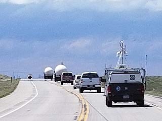
Storm chasers racing south on I-27 towards isolated supercells north of Lubbock, Texas late in the day on May 23. Many chasers abandoned the northern storms that were outflow dominant for the southern storms.Place: Kress, Texas (34.365, -101.748) Address: Kress, Texas 79052
Posted: Jun 3, 2019, 11:33 AM
Chris Collura added a new photo.
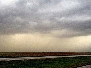
Storm cycling and producing another large funnel, or even a brief tornado, west of Childress, Texas on May 20. The view is to the SSE. This same storm will eventually produce another series of tornadoes, including the one near Mangum, Oklahoma.Place: Coleyville, Texas (34.2339, -100.379) Address: Coleyville, Texas
Posted: Jun 3, 2019, 11:33 AM
Chris Collura added a new photo.
Chaser convergence on the side of the road south of Crosbyton, Texas in Hale County on May 24.Place: Crosbyton, Texas (33.6567, -101.239) Address: Crosbyton, Texas 79322
Posted: Jun 3, 2019, 11:33 AM
Chris Collura added a new photo.
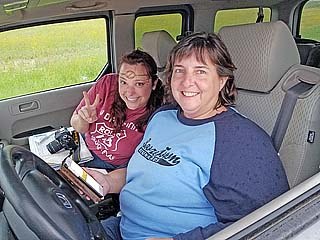
Chris Kridler and her chase partner south of Crosbyton, Texas on May 24.Place: Crosbyton, Texas (33.6567, -101.239) Address: Crosbyton, Texas 79322
Posted: Jun 3, 2019, 11:33 AM
Chris Collura added a new photo.
Heading west on Highway 34 as storms initiate to the southwest of Fort Morgan, Colorado during the afternoon of May 27. This is a caravan consisting of members of the TORUS research group.Place: Hillrose, Colorado (40.3256, -103.521) Address: Hillrose, Colorado 80733
Posted: Jun 3, 2019, 11:33 AM
Chris Collura added a new photo.
Doppler (base reflectivity) radar image of a tornadic supercell west of Iowa City and near Williamsburg, Iowa late in the day on May 29. The inset shows the intense Doppler velocity as well as my position in the blue cross-hair circle.
Posted: Jun 3, 2019, 11:33 AM
Chris Collura added a new photo.
View looking southward along the dryline / cold front intersection from north of Plainview, Texas late in the day on May 24.Place: Kress, Texas (34.365, -101.748) Address: Kress, Texas 79052
Posted: Jun 3, 2019, 11:33 AM
Chris Collura added a new photo.
Reed Timmer and his "dominator 3" chase vehicle during a large chaser convergence north of Lamar, Colorado late in the day on May 26.Place: Wiley, Colorado (38.155, -102.719) Address: Wiley, Colorado 81092
Posted: Jun 3, 2019, 11:33 AM
Chris Collura added a new photo.
Doppler on wheels truck west of Clay Center, Kansas during the early evening of May 28.Place: Miltonvale, Kansas (39.34833, -97.45306) Address: Miltonvale, Kansas 67466
Posted: Jun 3, 2019, 11:33 AM
Chris Collura added a new photo.
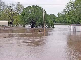
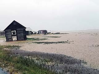
Severe flooding near the Arkansas River was encountered on the way to the target area on May 22, 2019. This is near Arkansas City, with swift flowing water inundating a field and farmstead. Flooding was a very serious issue during this period for many areas.Place: Arkansas City, Kansas (37.0653, -97.0396) Address: Arkansas City, Kansas 67005
Posted: Jun 3, 2019, 11:33 AM
Chris Collura added a new photo.

Extreme flooding in the Texas Panhandle north of Crosbyton after many thunderstorms "trained" over the same area within a large MCS of strong and severe storms. Many fields were noticed underwater with water rushing across roadways late in the day on May 24.Place: Estacado, Texas (33.7522, -101.561) Address: Estacado, Texas
Posted: Jun 3, 2019, 11:33 AM
Chris Collura added a new photo.
Rushing water over a cemetery in Hale County (west of Crosbyton), Texas late in the day on May 24.Place: Ralls, Texas (33.679444444444, -101.38361111111) Address: Ralls, Texas 79357
Posted: Jun 3, 2019, 11:33 AM
Chris Collura added a new photo.
Severe flooding of a farmstead in Hale County, Texas late in the day on May 24. Scenes like this went on for many miles with roads barely passable.Place: Cone, Texas (33.7972, -101.387) Address: Cone, Texas 79357
Posted: Jun 3, 2019, 11:33 AM
Chris Collura added a new photo.
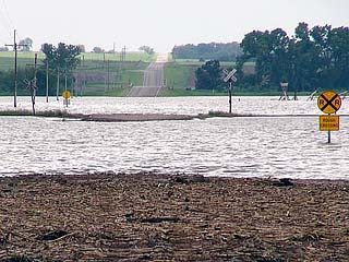
Severe flooding and a closed road (Jeep Road) south of Enterprise, Kansas during the afternoon of May 28. There are submerged railroad tracks there too.
Posted: Jun 3, 2019, 11:33 AM
Chris Collura added a new photo.

View of rotating area and funnel cloud associated with a supercell storm east of Lubbock, Texas and near Idalou late in the afternoon of May 23 near sunset.
Posted: Jun 3, 2019, 11:33 AM
Chris Collura added a new photo.

@[728003426:2048:Dave Lewison] and Scott McPartland south of Crosbyton, Texas on May 24.Place: Crosbyton, Texas (33.6567, -101.239) Address: Crosbyton, Texas 79322
Posted: Jun 3, 2019, 11:33 AM
Chris Collura added a new photo.

View of rain-free base of a developing tornadic supercell near McPherson, Kansas during the afternoon of May 21.Place: Moundridge, Kansas (38.2025, -97.5186) Address: Moundridge, Kansas 67107
Posted: Jun 3, 2019, 11:33 AM
Chris Collura added a new photo.

A weak tornado passes to my south at close range under the rotating wall cloud north of Brush, Colorado during the afternoon of May 27.Place: Fort Morgan, Colorado (40.2533, -103.799) Address: Fort Morgan, Colorado 80701 & 80705
Posted: Jun 3, 2019, 11:33 AM
Chris Collura added a new photo.
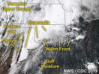
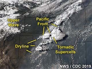
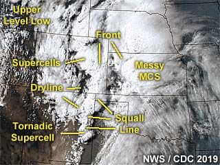
Annotated satellite image showing convective evolution and the synoptic setup during the afternoon of May 20, 2019. The linear nature of the dryline orientation (SW to NE instead of N to S) averted stronger tornadoes from forming on this day.
Posted: Jun 3, 2019, 11:33 AM
Chris Collura added a new photo.

May 24 was a chase day with the SPC issuing an enhanced risk in western Texas as per their 1630z outlook, which included a tornado probability of 5% as per the left image above. In the middle image is Mesoscale Discussion 769 showing a Pacific cold front and dryline intersection over the target area(s). To the right is tornado watch box 232 valid until 9 PM CDT.
Posted: Jun 3, 2019, 11:33 AM
Chris Collura added a new photo.

May 25 was another "enhanced risk" chase day in the Texas Panhandle plagued by weak capping that caused storms to fire early in the day and quickly become widespread. The enhanced risk as per the SPC 13z outlook is shown to the left image above, which contained a 10% tornado probability as shown. The middle image is Mesoscale Discussion 790 for the area, as well as tornado watch box 242 valid until 10 PM CDT to the right.
Posted: Jun 3, 2019, 11:33 AM
Chris Collura added a new photo.
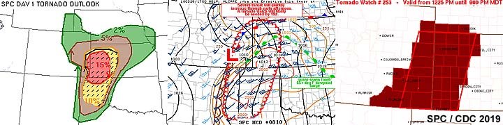
May 26 was another "moderate risk" chase day that really panned out as a grave disappointment, due to poor air quality (stable air) from expansive early morning convection persisting over Texas from the night before. In the image above, the SPC has a moderate risk in place as per 1630z, with the 15% hatched (significant) tornado area shown to the left. The middle image is Mesoscale Discussion 810 as well as subsequent tornado watch box 253, valid until 9 PM MDT (10 PM CDT) to the right.
Posted: Jun 3, 2019, 11:33 AM
Chris Collura added a new photo.

May 27 was a better chase day, with a nice post-frontal / up-slope setup in northeastern Colorado, with some tornadoes observed and not plagued by storms developing before even finishing lunch! In the left image above, the SPC had two enhanced risk outlooks, one over NE Colorado, and another way east and out of reach near Illinois. In the image, the tornado probabilities are shown as per the 13z SPC outlook, with the objective target area pointed out in the 5% area. The 10% significant far and distant tornado risk area to the east (northern Illinois) was not applicable for this chase day. The middle image shows Mesoscale Discussion 833 for the main target area. Tornado watch box 264, valid until 9 PM MDT is shown to the right.
Posted: Jun 3, 2019, 11:33 AM
Chris Collura added a new photo.
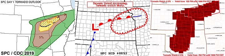
May 28 was a frustrating chase day with multiple targets requiring no "hesitation" once storms developed. The primary target area was from Topeka and eastward. In the SPC image to the left, a 10% tornado outlook is shown as per their 1630z moderate risk outlook. The middle image is Mesoscale Discussion 853. To the right are tornado watch boxes 275 and 276, both valid until 10 PM CDT. Hesitant decisions and straying too far from my target area caused me to miss tornadoes today.
Posted: Jun 3, 2019, 11:33 AM
Chris Collura added a new photo.
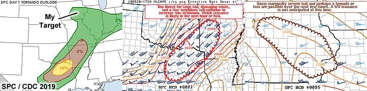
May 29 was both a marginal chase day and travel day, since I was already en-route to Chicago for down time during the succeeding days. Despite a large enhanced area to the far south and east (with a 10% tornado area in SE Texas and well out of reach), I decided on the "cold-core" setup in eastern Iowa, which had a 2% tornado outlook as per SPC at 1630z. The tornado probabilities and my target area are shown to the left. Both produced significant tornadoes. The middle image shows Mesoscale Discussion 882 for the far and distant SE Texas target. To the right, is Mesoscale Discussion 885 for my area targeted in eastern Iowa (no watch was issued there).
Posted: Jun 3, 2019, 11:33 AM
Chris Collura added a new photo.
Lubbock storm occluding with RFD clear slot late in the day on May 23.Place: Acuff, Texas (33.595, -101.62) Address: Acuff, Texas 79403
Posted: Jun 3, 2019, 11:33 AM
Chris Collura added a new photo.
This is a strong to severe thunderstorm complex near Janesville, Wisconsin on June 1, 2019. This storm contained strong winds near 60 MPH and large hail (hail shaft is to the left in this picture).
Posted: Jun 3, 2019, 11:33 AM
Chris Collura added a new photo.
View of strong tornado to the west of Wilson, Oklahoma and southwest of Okmulgee during the afternoon of May 22. Fortunately this large tornado remained over open / rural areas.
Posted: Jun 3, 2019, 11:33 AM
Chris Collura added a new photo.
View of highly rain-wrapped region of the Hall County, Texas supercell near Brice on May 25. This is possible a rain wrapped tornado, with just a violent wind shift (70+ MPH) occurring with a cloud base visible in heavy rains and hail. Unfortunately, this system continued into Oklahoma and caused damage and fatalities after midnight in El Reno.Place: Turkey, Texas (34.3942, -100.895) Address: Turkey, Texas 79261
Posted: Jun 3, 2019, 11:33 AM
Chris Collura added a new photo.
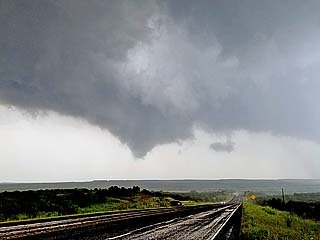
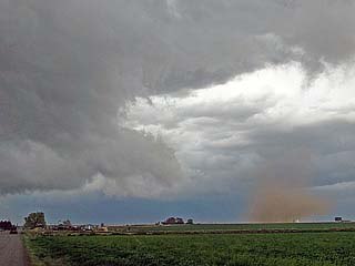
Tornado touches down near Paducah, Texas during the early to mid afternoon of May 20. The view is to the WSW.
Posted: Jun 3, 2019, 11:33 AM
Chris Collura added a new photo.

View of HP supercell as it was moving out of NE Colorado late in the day of May 27 east of Holyoke. The multi-vortex tornado can be seen just left of the roadway.Place: Lamar, Nebraska (40.57247, -101.97847) Address: Lamar, Nebraska 69023
Posted: Jun 3, 2019, 11:33 AM
Chris Collura added a new photo.

May 23 was another "moderate risk" chase day with the SPC having a moderate risk outlook as per 1630z with a 10% area for tornadoes (hatched for significant) in the area (Texas Panhandle) depicted in the left image above. In the middle image, Mesoscale Discussion 753 is shown, and subsequent tornado watch box 221 over a large parallelogram area to the right, valid until 10 PM CDT.
Posted: Jun 3, 2019, 11:33 AM
Chris Collura added a new photo.

While approaching the Tipton / Beloit, Kansas supercell a "day late and a dollar short", a brief glimpse of the last tornado produced by that storm is barely visible in this picture (circled) from about 20 miles out.
Posted: Jun 3, 2019, 11:33 AM
Chris Collura added a new photo.

Thin rope stage of the Paducah, Texas tornado on May 20. The view is to the W.
Posted: Jun 3, 2019, 11:33 AM
Chris Collura added a new photo.

Close up view of the tornado near Paducah, Texas on May 20 showing the thin and hollow structure of the vortex tube.
Posted: Jun 3, 2019, 11:33 AM
Chris Collura added a new photo.
Developing tornado west of Wilson, Oklahoma on May 22.Place: Schulter, Oklahoma (35.5136, -95.9564) Address: Schulter, Oklahoma 74460
Posted: Jun 3, 2019, 11:33 AM
Chris Collura added a new photo.

Tornado now west of Okmulgee, Oklahoma begins to lift and weaken as the supercell occludes late on May 22.
Posted: Jun 3, 2019, 11:33 AM
Chris Collura added a new photo.
Suction vortex in the HP notch / multi-vortex tornado briefly visible west of Imperial, Nebraska on May 27. The view is to the west.Place: Lamar, Nebraska (40.57247, -101.97847) Address: Lamar, Nebraska 69023
Posted: Jun 3, 2019, 11:33 AM
Chris Collura added a new photo.
Another brief view into the supercell notch reveling a multi-vortex tornado west of Imperial, Nebraska on May 27. The view is to the northwest.
Posted: Jun 3, 2019, 11:33 AM
Chris Collura added a new photo.
A brief tornado (dust swirl barely visible left of the road and pole) forms between Yuma and Holyoke, Colorado with an impressive wall cloud / funnel late in the afternoon of May 27.
Posted: Jun 3, 2019, 11:33 AM
Chris Collura added a new photo.
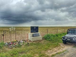
Visiting the "Samaras Memorial" near El Reno, Oklahoma during the morning of May 23 before heading west to the Texas Panhandle. Three storm chasers / scientists: Tim and his Son, Paul Samaras, and Carl Young - Perished in a large and deadly tornado on May 31, 2013 nearby this monument.Place: Banner, Oklahoma (35.5128, -97.8486) Address: Banner, Oklahoma
Posted: Jun 3, 2019, 11:33 AM
Chris Collura added a new photo.

View looking west towards a possible large tornado and satellite funnel rotating around it west of Williamsburg, Iowa late on May 29. The view is to the west.
Posted: Jun 3, 2019, 11:33 AM
Chris Collura added a new photo.

Close-up of funnel / tornado on near Williamsburg, Iowa on May 29 before the storm weakened.Place: Williamsburg, Iowa (41.6643, -92.0123) Address: Williamsburg, Iowa 52361
Posted: Jun 3, 2019, 11:33 AM
Chris Collura added a new photo.
Another view of the funnel / developing tornado near Williamsburg, Iowa on May 29 a few minutes later.
Posted: Jun 3, 2019, 11:33 AM
Chris Collura added a new photo.
View of an area of intense rotation from within the RFD of the supercell looking north of Imperial, Nebraska along SR 61 late on May 27. This was a multi-vortex tornado and had brief suction spots observed by many chasers, even the TORUS research group. Winds here were gusting out of the west near 80 MPH in RFD.Place: Imperial, Nebraska (40.5184, -101.642) Address: Imperial, Nebraska 69033
Posted: Jun 3, 2019, 11:33 AM
Chris Collura added a new photo.
View of funnel / developing tornado on a small supercell storm near Williamsburg, Iowa late in the day on May 29. The view is to the SSW.
Posted: Jun 3, 2019, 11:33 AM
Chris Collura added a new photo.
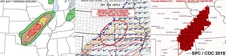
May 22 was a pretty successful chase day with rather complex forecast, with the main target in NE Oklahoma south of Tulsa and well east of Oklahoma City. In the images above, the SPC tornado outlook is shown to the left, with a significant (hatched) 15% tornado outlook in a moderate risk area as per 20z. In the middle image is Mesoscale Discussion 734 ahead of a slow moving Pacific cold front in the pre-frontal warm sector (confluence zone). To the right is tornado watch box 212, valid for the area until 11 PM CDT.
Posted: Jun 3, 2019, 11:33 AM
Chris Collura added a new photo.
Incredible stream-wise vorticity current screaming into the northeast side of the supercell storm from right to left looking northwest of Imperial, Nebraska on May 27.Place: Imperial, Nebraska (40.5184, -101.642) Address: Imperial, Nebraska 69033
Posted: Jun 3, 2019, 11:33 AM
Chris Collura added a new photo.
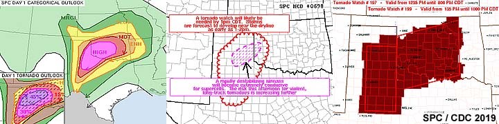
May 20 was a high risk chase day from the SE Texas panhandle and points northeastward through southwest Oklahoma. The SPC had a rare high-risk in place, with a hatched (significant) tornado probability of 45 percent as shown in the left image above and its inset. The middle image is one of many Mesoscale Discussions issued that day, MCD 698 in this case. To the right is the PDS (particularly dangerous situation) tornado watch boxes 197 and 199 in effect for the are until 8 PM CDT and 10 PM CDT, respectively.
Posted: Jun 3, 2019, 11:33 AM
Chris Collura added a new photo.
Another weak tornado being pushed ahead of the parent mesocyclone as the supercell becomes outflow dominant north of Brush, Colorado during the afternoon of May 27.Place: Fort Morgan, Colorado (40.2533, -103.799) Address: Fort Morgan, Colorado 80701 & 80705
Posted: Jun 3, 2019, 11:33 AM
Chris Collura added a new photo.
Annotated satellite image showing convective evolution and the synoptic setup during the afternoon of May 22. Tornadic supercells are developing in NE Oklahoma and northeastward into SW Missouri.
Posted: Jun 3, 2019, 11:33 AM
Chris Collura added a new photo.

Annotated satellite image showing convective evolution and the synoptic setup during the afternoon of May 23, 2019. The complicated evolution is depicted here, with a linear MCS developing withing the storm environment, which unexpectedly produced a significant tornado to the northeast. More supercells are developing south near Lubbock, Texas.
Posted: Jun 3, 2019, 11:33 AM
Chris Collura added a new photo.
Annotated satellite image showing convective evolution and the synoptic setup during the afternoon of May 24, 2019. It is apparent that this was to be more of a flooding event than tornadoes, with storms developing early in the day and becoming widespread by mid afternoon.
Posted: Jun 3, 2019, 11:33 AM
Chris Collura added a new photo.
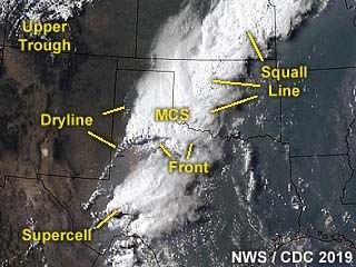
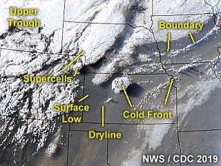
Annotated satellite image showing convective evolution and the synoptic setup during the afternoon of May 25, 2019. The biggest supercells developed only on the edges of a highly overturned boundary layer, including two that were southeast of the expansive MCS / MCC complex of storms.
Posted: Jun 3, 2019, 11:33 AM
Chris Collura added a new photo.
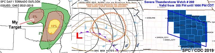
May 21 was a basic "cold-core" setup with the occluded front providing prospects for severe weather east and northeast of a surface low. In the left image, the separate 5% tornado area (as per SPC on their 1630z slight / enhanced risk outlook) to the NW of the messy MCS / linear storms over the Ozarks (10% area) was the target of the day. In the middle image, Mesoscale Discussion 725 is shown for the area chased, as well as subsequent severe thunderstorm watch box 208 in the right image.
Posted: Jun 3, 2019, 11:33 AM
Chris Collura added a new photo.
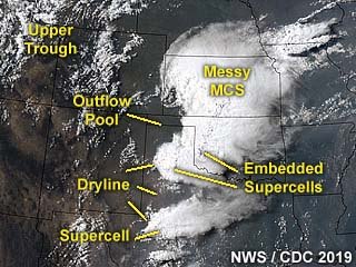
Annotated satellite image showing convective evolution and the synoptic setup during the afternoon of May 26, 2019. Once again, in lieu of the past 3 days now, storms are firing too early in the day and quickly becoming widespread, destructively interfering with one another. The only viable tornadic storm that produced a large photogenic tornado was near Dora, New Mexico (and not even in any SPC tornado outlook area)!
Posted: Jun 3, 2019, 11:33 AM
Chris Collura added a new photo.
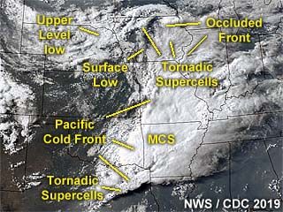
Annotated satellite image showing convective evolution and the synoptic setup during the afternoon of May 27, 2019. The supercell storms of interest are in an area anywhere from Fort Morgan, Colorado, and eastward through Holyoke and near Imperial, Nebraska late in the period.
Posted: Jun 3, 2019, 11:33 AM
Chris Collura added a new photo.
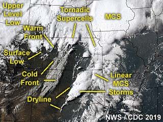
Annotated satellite image showing convective evolution and the synoptic setup during the afternoon of May 28, 2019. Tornadic supercells have formed to the southwest of Kansas City (with a destructive rain-wrapped tornado near Lawrence) as well as farther west in north-central, Kansas - Which produced highly photogenic and visible tornadoes near Tipton.
Posted: Jun 3, 2019, 11:33 AM
Chris Collura added a new photo.
Annotated satellite image showing convective evolution and the synoptic setup during the afternoon of May 29, 2019. The main area chased was in eastern Iowa, owing to a cold-occlusion and "cold-core" environment east of a surface low.
Posted: Jun 3, 2019, 11:33 AM
Chris Collura added a new photo.
View of developing supercell anvil in an extremely unstable environment south of Tulsa, Oklahoma during the afternoon of May 22. This is the main target storm being approached, and the view is to the southwest.
Posted: Jun 3, 2019, 11:33 AM
Chris Collura added a new photo.
View of the base of the soon-to-be tornadic supercell southwest of near Okmulgee, and near Wilson, Oklahoma during the afternoon of May 22. Note the wall cloud and funnel developing. The view is to the west.Place: Schulter, Oklahoma (35.5136, -95.9564) Address: Schulter, Oklahoma 74460
Posted: Jun 3, 2019, 11:33 AM
Chris Collura added a new photo.
Short lived but intense supercell storm near Springfield, Colorado during the early afternoon of May 26.Place: Vilas, Colorado (37.3742, -102.447) Address: Vilas, Colorado 81087 (PO Box)
Posted: Jun 3, 2019, 11:33 AM
Chris Collura added a new photo.
Annotated satellite image showing convective evolution and the synoptic setup during the afternoon of May 21, 2019. This is a cold-core setup with supercells developing in a cold-occlusion boundary.
Posted: Jun 3, 2019, 11:33 AM
Chris Collura added a new photo.
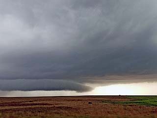
View looking west at an occluded supercell / line segment near Sharon Springs, Kansas late in the day of May 26. A brief rain wrapped tornado was reported inside this complex of storms at the time.Place: Cheyenne Wells, Colorado (38.8211, -102.354) Address: Cheyenne Wells, Colorado 80810
Posted: Jun 3, 2019, 11:33 AM
Chris Collura added a new photo.

The Yuma, Colorado supercell starts out as an LP storm with a high base, then becomes more classic with the arrival of upper level support and up-slope moisture influx during the afternoon of May 27.Place: Lone Star, Colorado (40.3519, -102.851) Address: Lone Star, Colorado
Posted: Jun 3, 2019, 11:33 AM
Chris Collura added a new photo.

The supercell grows and becomes classic to HP mode as it nears the CO / NE border south of Holyoke, Colorado. A developing tornado can also be seen in the "notch" of this storm. This is during the early evening of May 27. The view is to the southwest.Place: Lamar, Nebraska (40.57247, -101.97847) Address: Lamar, Nebraska 69023
Posted: Jun 3, 2019, 11:33 AM
Chris Collura added a new photo.

Absolutely "jaw dropping" structure of the HP tornadic supercell storm near Imperial, Nebraska late in the day on May 27. Note the green "hail" color to the upper right with "stacked plates" structure, as well as a large tornado possibly on going just behind the tanks in the foreground.Place: Champion, Nebraska (40.469166666667, -101.74861111111) Address: Champion, Nebraska 69023
Posted: Jun 3, 2019, 11:33 AM
Chris Collura added a new photo.
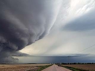
Another incredible view of the HP supercell to the northwest of Imperial, Nebraska on May 27 near SR 61. The view is to the northwest. Note the "beavers tail" extending above the stream-wise vorticity current from left to right in the lower portion of the photo.Place: Imperial, Nebraska (40.5184, -101.642) Address: Imperial, Nebraska 69033
Posted: Jun 3, 2019, 11:33 AM
Chris Collura added a new photo.
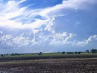
View about 40 miles from the Tipton / Beloit, Kansas tornadic supercell during the afternoon of May 28. I am rushing north and west to reach this storm. A large tornado was in progress when this photo was taken. The view is to the northwest.Place: Tescott, Kansas (39.0119, -97.8781) Address: Tescott, Kansas 67484
Posted: Jun 3, 2019, 11:33 AM
Chris Collura added a new photo.
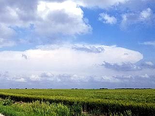
Distant view of the supercell storm that will become the destructive Kansas City / Lawrence tornado while trying to decide to go east or not during the afternoon of May 28. The storm here is 40 to 50 miles away and the view is to the east and southeast.Place: Herington, Kansas (38.6719, -96.9456) Address: Herington, Kansas 67449
Posted: Jun 3, 2019, 11:33 AM
Chris Collura added a new photo.
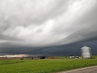
View of storm moving north of Williamsburg and west of Iowa City, Iowa late in the day on May 29. The view is to the NW and the storm is merging with another small supercell and evolving to a line / bow segment.Place: Oxford, Iowa (41.7226, -91.7898) Address: Oxford, Iowa 52322
Posted: Jun 3, 2019, 11:33 AM
Chris Collura added a new photo.
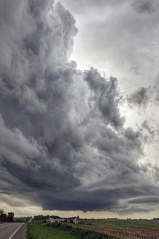
Small supercell storm and funnel near Williamsburg, Iowa late in the day on May 29. The view is to the SSW.
Posted: Jun 3, 2019, 11:33 AM
Chris Collura added a new photo.

Developing supercell storm west of Iowa City and north of Williamsburg, Iowa during the late afternoon of May 29. The view is to the west with a large wall cloud and updraft-downdraft interface (UDI) to its right.Place: Marengo, Iowa (41.797222222222, -92.069444444444) Address: Marengo, Iowa 52301
Posted: Jun 3, 2019, 11:33 AM
Chris Collura added a new photo.
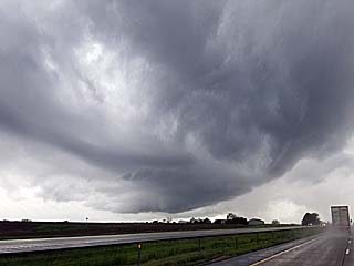
Small supercell storm developing along a cold occlusion west of Iowa City, Iowa during the late afternoon of May 29. The view is to the west and southwest from along I-80.Place: Victor, Iowa (41.730277777778, -92.297222222222) Address: Victor, Iowa 52347
Posted: Jun 3, 2019, 11:33 AM
Chris Collura added a new photo.

Small supercell storm with hail and rotation to the east of Clay Center, Kansas during the evening of May 28 before being undercut by the Pacific cold front / outflow. The view is to the east.Place: Clay Center, Kansas (39.38, -97.1231) Address: Clay Center, Kansas 67432
Posted: Jun 3, 2019, 11:33 AM
Chris Collura added a new photo.
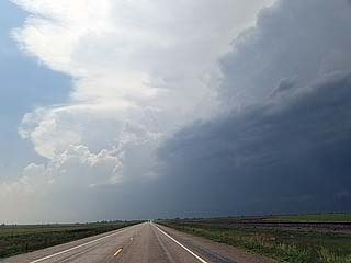
Approaching a tornadic supercell storm near Lamar and Wiley, Colorado during the afternoon of May 26.Place: Parrish, Colorado (38.1217, -102.384) Address: Parrish, Colorado
Posted: Jun 2, 2019, 6:07 PM
Chris Collura commented on Miranda Kay Roberts's post.
In Chicago these are going strong, advocated, and a huge "cash cow" for many city / private firms.
A few years ago I was nailed 3 times in a 4 month period working up here. And even worse, I didnt get the mail until a month or two later and ate the fees!
I even tried to fight one. Where a lady in front of me made right turn and I was behind her. I stopped but she didnt. And I got my plate taken by the camera. That one was $100 and since I lost fighting it, it became $150.
All in all it was like $450. These things are a cause of accidents and the worst thing anyone can set up.
Posted: Jun 2, 2019, 5:33 PM
Chris Collura commented on a post.
Posted: Jun 2, 2019, 5:28 PM
Chris Collura commented on Stormtrack's post.
Mainly during hurricane chases. Rarely when in tornado alley.
Posted: Jun 2, 2019, 10:10 AM
Chris Collura commented on a post.
Posted: Jun 2, 2019, 10:09 AM
Chris Collura commented on a post.
Posted: Jun 2, 2019, 8:16 AM
Chris Collura commented on Kory Hartman's post.
Hate that shit. Usually a loose / bad cable. You DESERVE a full charge and you DONT get it :(
Posted: Jun 1, 2019, 7:40 PM
Chris Collura commented on Scott Peake Weather's photo.
Incredible SVC (streamwise vorticity current) / rotor issuing into the storm from the right. Just WOW!
Posted: Jun 1, 2019, 7:36 PM
Chris Collura commented on Bill Hark's post.
No rain wrap! Awesome!
Posted: Jun 1, 2019, 9:44 AM
Chris Collura commented on Lisa Beal's post.
Wow. Awesome job. I wonder if they used my pilot chute I gave Reed back in Feb (!)
Posted: Jun 1, 2019, 9:40 AM
Chris Collura commented on Jason Foster's photo.

Generated by Sky-Chaser Chris Collura on Wednesday, March 24, 2021 at 6:19 PM UTC-07:00
HTML File "indx1906.htm" (Facebook) - Developed By Chris Collura

My Contact Information Is Given In The Graphic Above
To Prevent SPAM And Abuse - The EMAIL Banner Above Only Links To My Information Page
For My EMAIL - You Will Need To Take It Down And Enter It In Your EMAIL Package
To Return To The HOME Page Of This Site Click The "INDEX.HTM" Link Here!