
Facebook Timeline Posts For July 2019
(Posts And Comments During July 2019 For Sky-Chaser Chris Collura On Facebook)
[ 2019-AUG ] [ BACK TO INDEX ] [ 2019-JUN ]
Posts And Comments For July 2019
Posted: Jul 31, 2019, 6:04 PM
Chris Collura commented on iCyclone's photo.
I see many less experienced hurricane chasers eyeing these two storms up. Two even bought tickets and went out there - Just like they both did last year for hurricane "Lane".
Remember there are NO Motel 6 nor Suoer 8 motels in Hawaii. No where! Cheapest rooms will run $200+ a night, car rentals there are $120 a day (instead of $20), and airfares are $500 and up. A hamburger in Hawaii is also $15, not $5. Gas is $4 instead of $3. Consider that too.
Like you I didnt even consider chasing these. Shear and cooler waters will weaken these long before they gets even to the big island.
Like many in S California, if you surf, that's a different story. Even S California will see huge swells from these let alone Hawaii.
Posted: Jul 31, 2019, 5:04 PM
WHY did FB remove the ability to choose from a gallery when posting a picture? They had that ability and removed it. WTF?I'm so damn frustrated. On messenger they removed the choose gallery option too. I understand you need to piss off the MSNBC / CNN freaks / Trump "bashers", but come on!!!
Posted: Jul 31, 2019, 4:56 PM
Chris Collura commented on Doug Crisp's post.
Posted: Jul 31, 2019, 4:53 PM
Chris Collura commented on Doug Crisp's post.
Looking to the SE from east of Tescott. I was going to attach the pic but since FB REMOVED the ability to choose the galleries I just couldn't find it after searching through 1000s of pics on my phone, porn, amongst other pics :(
Posted: Jul 31, 2019, 4:50 PM
Chris Collura replied to Cathy Dempster's comment.
Posted: Jul 30, 2019, 4:52 PM
Chris Collura commented on a post.
Posted: Jul 30, 2019, 4:49 PM
Chris Collura replied to Doug Kiesling's comment.
Doug Kiesling No the immigration in Windsor there will lock you up for 6 hours just for being a tourist driving a blue Ford Focus :)
Posted: Jul 30, 2019, 4:00 PM
Chris Collura replied to Bob Conzemius's comment.
Bob Conzemius We cant just LEAVE Facebook. We just refrain from starting and / or being involved in unnecessary drama on it. And eliminating friends so that it's just content related (such as links back to content, if the FB algorithm allows even that)!
Posted: Jul 30, 2019, 1:32 PM
Chris Collura replied to Neva Andersen's comment.
Neva Andersen Goes to show where our world is going. If it was a horror movie showing people being tortured (like the Saw movies) it would spend 6 months in theaters.
Posted: Jul 30, 2019, 1:29 PM
Chris Collura commented on Doug Kiesling's photo.
Happy birthday Doug Kiesling!
Posted: Jul 30, 2019, 1:28 PM
Chris Collura commented on Derek Sibley's photo.
With this season (in that part of the country) its certainly NOT hail :[
Posted: Jul 27, 2019, 9:18 PM
Chris Collura replied to his own comment.
Posted: Jul 27, 2019, 9:12 PM
Chris Collura replied to Neva Andersen's comment.
Neva Andersen I wanted to see it in IMAX but they released it for one f'cken day. Jesus.
Posted: Jul 27, 2019, 5:22 PM
Chris Collura commented on his own post.
Well it was in IMAX. Not sure why they pulled it so quick. Something I like always done away with.
I turn 50 TOO in late September (and NO one will even notice) :(
Stupid Millenials and their GARBAGE.
Posted: Jul 27, 2019, 4:54 PM
Chris Collura commented on Reference.com's post.
That's a juvenile Portuguese man of war.
Posted: Jul 27, 2019, 4:53 PM
Chris Collura commented on Billy Wade's post.
Never heard of him = until I opened up FB this morning.
Another one bites the dust?
#ChasersDroppinLikeFlies
Posted: Jul 27, 2019, 4:51 PM
Chris Collura is feeling angry.
Looks like Apollo 11 just came and went like a breeze, or Trump being impeached (on CNN).
For something that epic, try to keep it in theaters for a bit longer. But no ... Unlike geeks like me = people wanna see drama, cartoons, and violence.
WelCUM 2 America :-(
Posted: Jul 27, 2019, 4:49 PM
Chris Collura commented on Erik Toth's post.
Doug Kiesling shared this to my timeline too. Pretty wild.
Posted: Jul 27, 2019, 4:44 PM
Chris Collura commented on Daniela Fuentes's album.
http://sky-chaser.com/accident.htm
Posted: Jul 27, 2019, 4:42 PM
Chris Collura commented on a post.
Posted: Jul 27, 2019, 12:19 PM
Chris Collura replied to his own comment.
iCyclone Yeah. And my dad said "I hope you're happy - your gonna get a hurricane since you wished for it" since we're in FL. But it recurved.
Yeah. That wasn't easy. Plus all that flack. Ugh. Should have stayed up there another few months :/
Posted: Jul 27, 2019, 12:17 PM
Chris Collura commented on Mark Robinson's photo.
Brampton is west of Toronto.
Posted: Jul 27, 2019, 12:16 PM
Chris Collura commented on a post.
Posted: Jul 26, 2019, 9:25 PM
Chris Collura replied to Scott Carter Walsh's comment.
Robert Joseph Wilson Huge difference since then.
Posted: Jul 26, 2019, 9:12 PM
Chris Collura commented on iCyclone's photo.
AND this happened a month after I moved (from Islip, Long Island of all places) to south Florida with my parents. I was only 15. It was tough :[
Posted: Jul 26, 2019, 9:24 AM
Chris Collura replied to Scott Carter Walsh's comment.
That's right - a professional will monitor your health if he or she is on top of it. Plus going forward this particular set of HIV drugs is MUCH safer after 2017. With ANY medication, always be aware of the risks.
Posted: Jul 26, 2019, 9:22 AM
Chris Collura replied to Jeff Hensel's comment.
Allen Tedesco Like ANY medication, not just ones for HIV. Ever see the side effects for arthritis medicines or those for depression? That will make Truvada look like cotton candy!
Posted: Jul 26, 2019, 9:17 AM
Chris Collura commented on a post.
Posted: Jul 24, 2019, 7:32 PM
Chris Collura commented on William T. Reid's photo.
Yeah it was crazy hot in Long Beach too, 99 to 100 deg and I was like "wheres the damn sea breeze?" ... Back here in Anaheim it's a more comfortable 87 deg. Thanks God these temperatures don't have high humidity.
Posted: Jul 24, 2019, 1:28 PM
Chris Collura commented on NASA History's photo.
And that's it. All of humanity. Religion. Happiness. Violence. Disease. Success. World powers. Asians. Negros. All other races. Trump. Gorbachov. Castro. Beauty. The good, bad, and in between. It's a SMALL PLACE ... Protect it.
Posted: Jul 24, 2019, 1:20 PM
Chris Collura commented on Max Olson's photo.
Posted: Jul 23, 2019, 4:39 PM
Chris Collura commented on Lawsuit Watch's video.
The packaging did say all the details. READ it 📖📖📖 :)
Posted: Jul 23, 2019, 4:37 PM
Chris Collura replied to JS Broussard's comment.
JS Broussard Exactly. These are unlikely as the offending ingredient was removed in 2017. Grow up.
Posted: Jul 23, 2019, 4:35 PM
Chris Collura commented on HIV Medication Injury Claims's post.
Bone diseases? Kidney disease? Only if before 2017...
...beats painful condomes. And you won't get HIV. Jesus.
Posted: Jul 23, 2019, 3:55 PM
Chris Collura replied to his own comment.
Posted: Jul 23, 2019, 3:54 PM
Chris Collura replied to his own comment.
Posted: Jul 23, 2019, 3:32 PM
Chris Collura commented on a post.
Posted: Jul 23, 2019, 3:28 PM
Chris Collura is feeling irritated.
Someone replies on a personal message (luckily it was just a non important / joke message) ... BUT to lots of contacts I'm my "friends list" as a group chat. Ouch!
Simple solution is looking up on what is called a "heading" (no brainer for all you IT folks) and make SURE who you are responding too. You might surprise MORE than just yourself (when it's too late]!
Tunnel vision is bad. Very BAD :/
Posted: Jul 22, 2019, 8:04 PM
Chris Collura commented on Chicagoland Skydiving Center's photo.
That's one heck of a drought. Just kidding!
Posted: Jul 22, 2019, 8:01 PM
Chris Collura replied to Sajjaad Pop Saleem's comment.
Sajjaad Pop Saleem Yup. Agreed. If its BEFORE 2017 get off it ASAP !!!!!!!!!!!!
Posted: Jul 22, 2019, 8:01 PM
Chris Collura commented on Max Olson's photo.

Posted: Jul 22, 2019, 7:14 PM
Chris Collura replied to Jack Corso's comment.
Mainly sick kids. Always the worst cold too. And often I have to see doctor ($$$$$) when I get a summer cold (doesn't go away) :(
Posted: Jul 22, 2019, 7:11 PM
Chris Collura commented on Billy Wade's photo.
SLOW Food.
The order is taken FAST but then you gotta wait long to get it.
Also, never just grab the bag and dash out = CHECK it! Alas - Its seldom correct.
Posted: Jul 22, 2019, 5:55 PM
Chris Collura replied to his own comment.
Biagio Prestifilippo Rear cylinder lost compression. So new engine basically.
Posted: Jul 22, 2019, 1:52 PM
Chris Collura updated his status.
Haven't been this sick in many years. These summer colds are like freak winter tornadoes in Maine (unexpected and far worse than regular ones you supposed to get during the "main" season)...
...To the sick lady in front of me in Walmart a few days ago with 3 kids = Thanks for being a prick and not covering your mouth when you sneezed near my cart!
Thanks ... Now it's 2 weeks of misery and a cough that most likely will last 2 or 3 times that ;(
Posted: Jul 20, 2019, 9:50 AM
Chris Collura commented on Stormtrack's post.

Posted: Jul 20, 2019, 9:48 AM
Chris Collura commented on Dave Lewison's photo.
Keep it brown. The white stripe creates a discontinuity and it's too much. Keep it simple.
Posted: Jul 19, 2019, 8:07 PM
Chris Collura commented on Roger Edwards's photo.
White Sands, NM?
Posted: Jul 19, 2019, 8:06 PM
Chris Collura commented on Billy Wade's post.
Posted: Jul 19, 2019, 8:05 PM
Chris Collura commented on Margie Kieper's post.
Holy cow. Had no idea all this was going on until now.
Posted: Jul 19, 2019, 8:03 PM
Chris Collura replied to his own comment.
Roger Edwards Yeah and the parties and BBQs he threw each year at his place in the Keys. Right on the water too, even brought my jet ski there a couple years when I had it. What a blast!
Posted: Jul 19, 2019, 7:58 PM
Chris Collura commented on Roger Edwards's post.

Posted: Jul 19, 2019, 7:57 PM
Chris Collura replied to Randall H. Oliver's comment.
Randall H. Oliver I sometimes feel his spirit. He definitely was all around us in the eye of hurricane Michael, for sure.
Posted: Jul 19, 2019, 7:56 PM
Chris Collura commented on Roger Edwards's post.
Sigh... Jesus. May he rest in peace. Jim Leonard was such an influence and inspiration in my life as well. Even many things I do and love were inspired by him (besides hurricanes). I miss him so much.
Posted: Jul 19, 2019, 3:40 PM
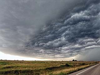
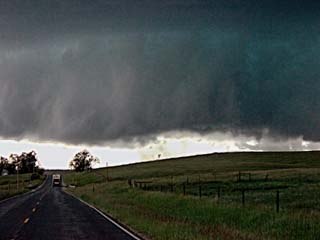
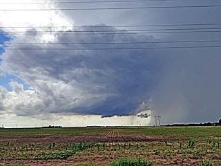
Chris Collura added a new photo.

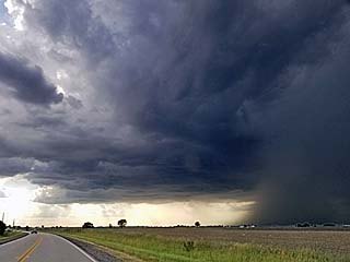
Severe flooding and a closed road (Jeep Road) south of Enterprise, Kansas during the afternoon of May 28. There are submerged railroad tracks there too.
Posted: Jul 19, 2019, 3:35 PM
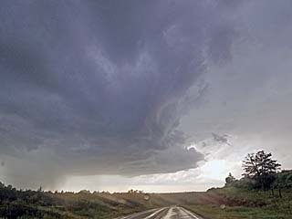
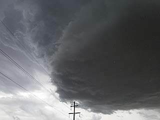
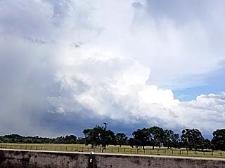
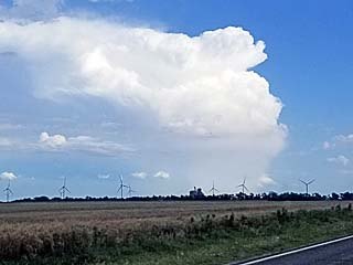
Chris Collura added a new photo.
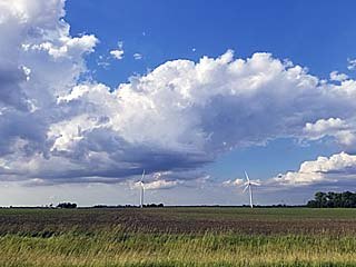
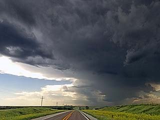
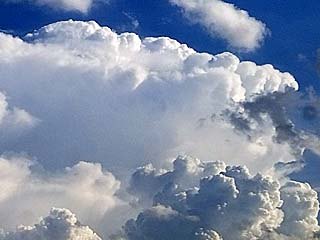
Developing supercell storm west of Aurora, Illinois late in the day on June 26.Place: Sugar Grove, Illinois (41.7725, -88.4424) Address: Sugar Grove, Illinois 60554
Posted: Jul 19, 2019, 3:35 PM
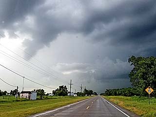
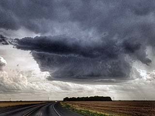
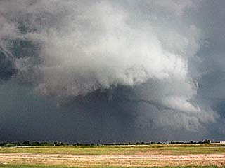
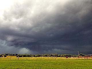
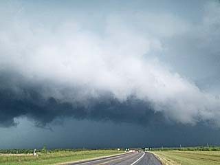
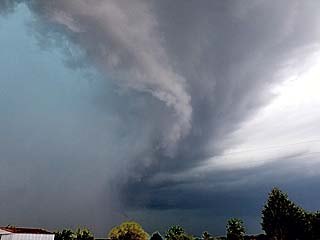
Chris Collura added a new photo.

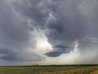
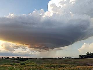
A slowly rotating wall cloud is visible on the southwestern side of a developing severe thunderstorm over Kane County (near Aurora), Illinois during the late afternoon / early evening of June 26.Place: Sugar Grove, Illinois (41.7725, -88.4424) Address: Sugar Grove, Illinois 60554
Posted: Jul 19, 2019, 3:35 PM
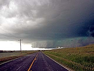
Chris Collura added a new photo.
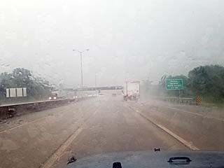
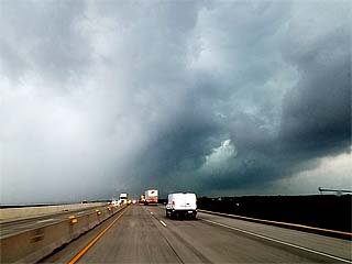
High winds, torrential rains, and hail blow through the area of Naperville in the western Chicago suburbs on June 26. The view is to the east on the I-88 tollway.Place: Aurora, Illinois (41.7601, -88.3163) Address: Aurora, Illinois 60502–60507, 60568, 60569, 60572, 60598
Posted: Jul 19, 2019, 3:35 PM
Chris Collura added a new photo.
Posted: Jul 19, 2019, 3:35 PM
Chris Collura added a new photo.

Posted: Jul 19, 2019, 3:35 PM
Chris Collura added a new photo.
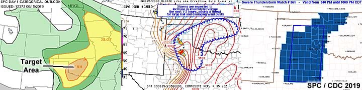
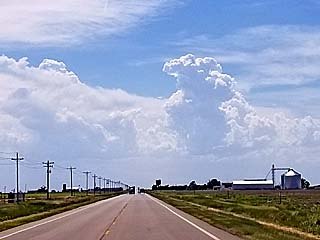
June 15 was a pretty interesting chase day with another enhanced risk in place for much of western Oklahoma as per the 13z and 1630z outlooks with a 2% probability of tornadoes that turned out to be important for this chase day. In the images above, the 13z enhanced outlook as per SPC is shown to the left with my target area annotated. In the middle and right images is Mesoscale Discussion 1080 and severe thunderstorm watch box 361, valid until 10 PM CDT, respectively.
Posted: Jul 19, 2019, 3:35 PM
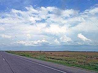
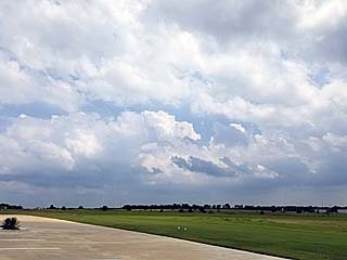
Chris Collura added a new photo.
Initiation of storms and towering cumulus between Rochelle and Aurora in northern Illinois late in the day on June 26, 2019.Place: Shabbona, Illinois (41.7674, -88.8747) Address: Shabbona, Illinois 60550
Posted: Jul 19, 2019, 3:35 PM
Chris Collura added a new photo.

Posted: Jul 19, 2019, 3:35 PM
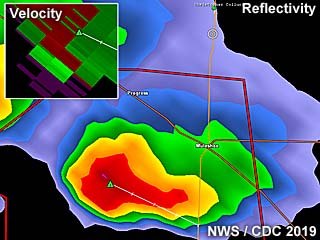
Chris Collura added a new photo.
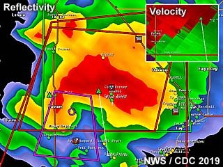
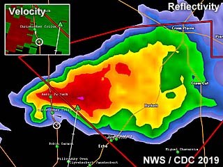
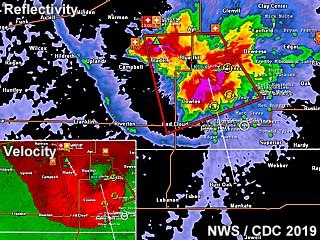
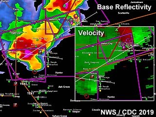
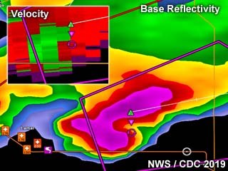
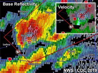
Base reflectivity radar image of a powerful tornadic HP supercell storm 25 miles north of Clinton, Oklahoma near Putnam and in Custer County near dark on June 15. This storm produced a large tornado at the time, and the impressive Doppler velocity of the storm is shown in the upper-right inset.
Posted: Jul 19, 2019, 3:35 PM
Chris Collura added a new photo.
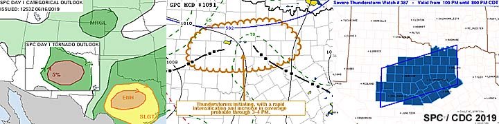
June 16 was a chase day with a long drive to west-central to central Texas for an enhanced risk area and a 5% probability of tornadoes. In the images above, the 13z enhanced outlook (with 5% tornado probability) is shown in the left image. To the middle image is Mesoscale Discussion 1091, showing the setup over Texas. To the right is severe thunderstorm watch 387 valid until 8 PM CDT.
Posted: Jul 19, 2019, 3:35 PM
Chris Collura added a new photo.
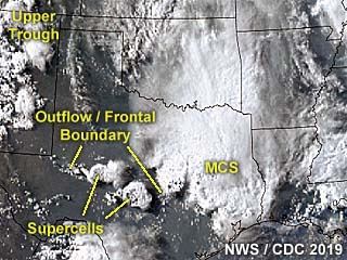
This is an annotated visible satellite image of the synoptic environment as of 23z on June 16, 2019. The area chased is also indicated in central Texas with isolated supercell storms developing there along a boundary.
Posted: Jul 19, 2019, 3:35 PM
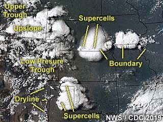
Chris Collura added a new photo.
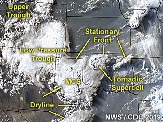
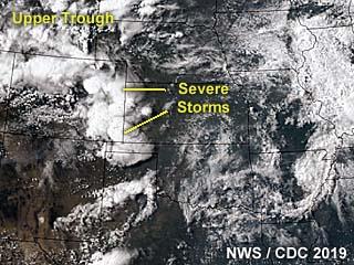
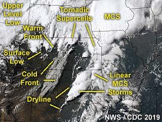
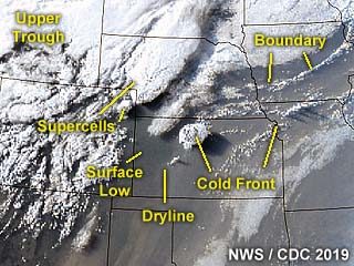
This is an annotated visible satellite image of the synoptic environment as of 23z on June 15, 2019. The annotation points out very important features, such as a stationary frontal boundary over northern Oklahoma and a dryline / trough over the Texas Panhandle. The tornadic supercell storm I was on is also shown developing in this image.
Posted: Jul 19, 2019, 3:35 PM
Chris Collura added a new photo.
Base reflectivity image of a classic / LP supercell storm northwest of Santa Anna (over Callahan County), Texas during the afternoon of June 16. Note the small "hook" in the reflectivity. The upper-left inset shows the Doppler velocity of the storm. My GPS location is the white circle.
Posted: Jul 19, 2019, 3:35 PM
Chris Collura added a new photo.
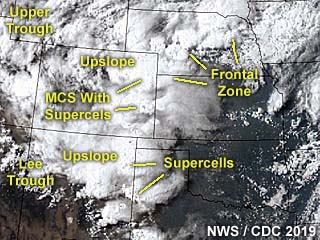
This is a visible satellite image of the synoptic environment as of 23z on June 17, 2019. The annotation points out important features of this rather complex setup. The main focus is up-slope wind flow in far western Texas.
Posted: Jul 19, 2019, 3:35 PM
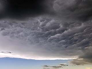
Chris Collura added a new photo.
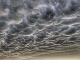
Incredible mammatus clouds looming in the sky near Hastings, Nebraska during the early evening of June 25.Place: McCool Junction, Nebraska (40.743333333333, -97.595555555556) Address: McCool Junction, Nebraska 68401
Posted: Jul 19, 2019, 3:35 PM
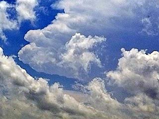
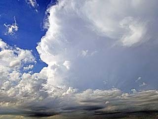
Chris Collura added a new photo.
Anvil blow-off and mammatus from the storm complex over south-central Nebraska during the afternoon of June 25.
Posted: Jul 19, 2019, 3:35 PM
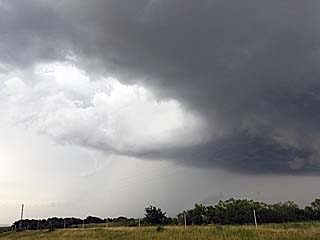
Chris Collura added a new photo.
Storms initiating along a boundary / confluence axis looking southeast of Woodward, Oklahoma late in the afternoon on June 22.Place: Mooreland, Oklahoma (36.4375, -99.205555555556) Address: Mooreland, Oklahoma 73852
Posted: Jul 19, 2019, 3:35 PM
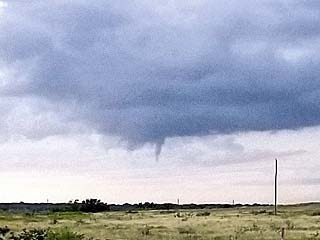
Chris Collura added a new photo.
Brief slowly rotating funnel (left of the center of the picture) with a storm near Major County, Oklahoma on June 22. The view is to the north and northwest.Place: Chester, Oklahoma (36.2157, -98.9213) Address: Chester, Oklahoma 73838
Posted: Jul 19, 2019, 3:35 PM
Chris Collura added a new photo.
Left split and weakening phase of a small supercell storm near Major County, Oklahoma on June 22. The view is to the west.Place: Cedardale, Oklahoma (36.3189, -98.9961) Address: Cedardale, Oklahoma
Posted: Jul 19, 2019, 3:35 PM
Chris Collura added a new photo.
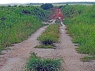
Would you try to drive on this so called "road" in the rain? I wouldn't, even with a Jeep unless a tornado was chasing me!Place: Cedardale, Oklahoma (36.3189, -98.9961) Address: Cedardale, Oklahoma
Posted: Jul 19, 2019, 3:35 PM
Chris Collura added a new photo.
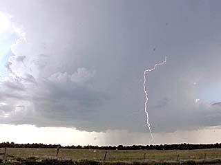
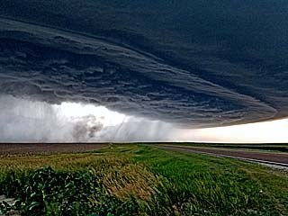
View of supercell structure (with CG lightning) within a cluster of severe storms developing over Major County, Oklahoma on June 22.
Posted: Jul 19, 2019, 3:35 PM
Chris Collura added a new photo.
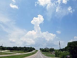
Cap erosion during the afternoon of June 23 over south-central Oklahoma / north-central Texas (near the Red River) and along an outflow boundary. A lone towering cumulus called called a "turkey tower" wells up above the weakening capping inversion.Place: Ardmore, Oklahoma (34.179, -97.1432) Address: Ardmore, Oklahoma 73401
Posted: Jul 19, 2019, 3:35 PM
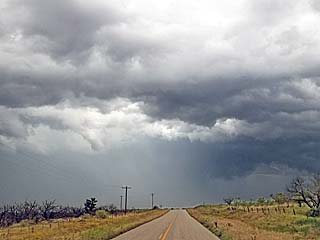
Chris Collura added a new photo.
Storms developing during the afternoon on June 23 over south-central Oklahoma / north-central Texas. Unfortunately, these storms will quickly become a multicell cluster / line of storms, and get undercut by outflow.Place: Cornish, Oklahoma (34.16019, -97.59308) Address: Cornish, Oklahoma
Posted: Jul 19, 2019, 3:35 PM
Chris Collura added a new photo.
A shelf cloud and "whales mouth" formation on it's backside as an outflow dominant severe storm complex is approached in Clay County, Texas on June 23.Place: Bluegrove, Texas (33.6739, -98.2297) Address: Bluegrove, Texas
Posted: Jul 19, 2019, 3:35 PM
Chris Collura added a new photo.
View of an area of rotation (note high based wall cloud and RFD clear slot) within the cluster of severe storms in north-central Texas late in the day on June 23.Place: Antelope, Texas (33.4417, -98.3694) Address: Antelope, Texas
Posted: Jul 19, 2019, 3:35 PM
Chris Collura added a new photo.

View of an HP supercell and wall cloud / rotating portion on the leading edge of persistent outflow during the late afternoon on June 25 pushing east out of Nuckolls / Thayer Counties in Nebraska. The view is to the west.Place: Superior, Nebraska (40.0225, -98.066944444444) Address: Superior, Nebraska 68978
Posted: Jul 19, 2019, 3:35 PM
Chris Collura added a new photo.

Looking back at mammatus clouds looming over the western sky in north-central Texas near dusk on June 23.Place: Purdy, Oklahoma (34.715833333333, -97.5875) Address: Purdy, Oklahoma
Posted: Jul 19, 2019, 3:35 PM
Chris Collura added a new photo.
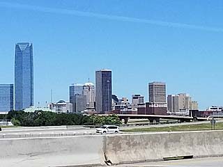
View of Oklahoma City while traveling to the Kansas City area on June 24. The Devon Energy Building is to the left and is the highest sky-scraper in the central USA west of the Mississippi River.Place: Oklahoma City, Oklahoma (35.4689, -97.5195) Address: Oklahoma City, Oklahoma
Posted: Jul 19, 2019, 3:35 PM
Chris Collura added a new photo.
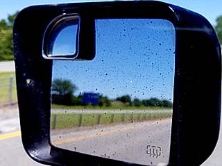
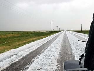
This is my driver's side mirror with the hail grill removed. It appears dirty with dark dust spots on it. Unfortunately these are pit marks from the June 21 storm (near Sharon Springs, Kansas) peppering it with rocks and sand, and the mirror needs to eventually be replaced.Place: Guthrie, Oklahoma (35.8563, -97.4359) Address: Guthrie, Oklahoma 73044
Posted: Jul 19, 2019, 3:35 PM
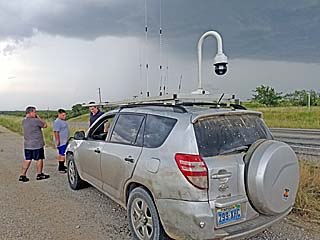
Chris Collura added a new photo.
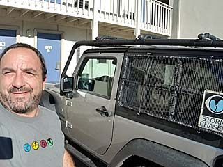
Myself enjoying the day off and preparing my vehicle for more activity starting right after May 19.Place: Blue Springs, Missouri (39.0082, -94.2726) Address: Blue Springs, Missouri 64013
Posted: Jul 19, 2019, 3:35 PM
Chris Collura added a new photo.

That dreadful feeling when you realize the "2019 storm chase season" is ending - Like baseball (or football) season ending for a sports fanatic - Just devastating? Just kidding! Posted this humorous shot just for kicks and see you all out there again in 2020!Place: Blue Springs, Missouri (39.0082, -94.2726) Address: Blue Springs, Missouri 64013
Posted: Jul 19, 2019, 3:35 PM
Chris Collura added a new photo.
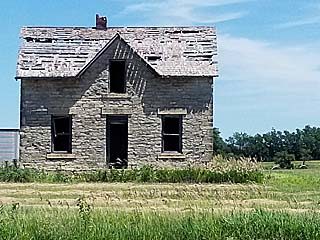
While driving through the American Midwest, and headed back to Chicago for "down time", here is one of many old houses quite literally "on the prairie", that are abandoned and slowly weathering away over the past century.Place: Randolph, Kansas (39.4301, -96.7596) Address: Randolph, Kansas 66554
Posted: Jul 19, 2019, 3:35 PM
Chris Collura added a new photo.

Convective initiation looking west over south-central Nebraska as a surface front / boundary is approached during the afternoon of June 25.Place: Blue Springs, Nebraska (40.137777777778, -96.662777777778) Address: Blue Springs, Nebraska 68318
Posted: Jul 19, 2019, 3:35 PM
Chris Collura added a new photo.
Approaching some supercell storms near Davenport, Nebraska during the afternoon on June 25. A low precipitation (LP) storm is to the east (in the foreground to the lower right) with a larger high precipitation (HP) storm forming to the west near the dryline / front triple-point. The view is to the west.Place: Gilead, Nebraska (40.1457, -97.4152) Address: Gilead, Nebraska 68362
Posted: Jul 19, 2019, 3:35 PM
Chris Collura added a new photo.
An LP supercell down-scaling after a storm split near Davenport, Nebraska during the afternoon on June 25.Place: Bruning, Nebraska (40.3357, -97.5649) Address: Bruning, Nebraska 68322
Posted: Jul 19, 2019, 3:35 PM
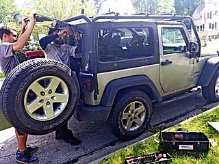
Chris Collura added a new photo.
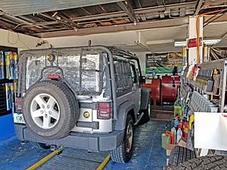
June 24 was a travel / off day. Here I am getting my vehicle done for routine maintenance in Oklahoma City before heading north to Kansas City later in the day.Place: Oklahoma City, Oklahoma (35.4689, -97.5195) Address: Oklahoma City, Oklahoma
Posted: Jul 19, 2019, 3:35 PM
Chris Collura added a new photo.
Base reflectivity image of an LP supercell storm near Muleshow (over Bailey County), Texas during the afternoon of June 17. The storm was high based and produced mainly hail. Weak velocity appears in the inset to the upper-left.
Posted: Jul 19, 2019, 3:35 PM
Chris Collura added a new photo.

Striated view of updraft and RFD region of the Custer County, OK supercell near dusk on June 15.Place: Thomas, Oklahoma (35.7464, -98.7483) Address: Thomas, Oklahoma 73669
Posted: Jul 19, 2019, 3:35 PM
Chris Collura added a new photo.
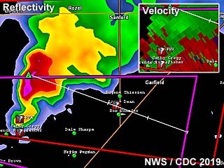
Base reflectivity radar image of a tornadic supercell storm over Hodgeman and Edwards Counties, Kansas during the afternoon of June 18. The classic supercell signature is shown, with the velocity to the upper-right. Storm spotter network icons also appear on this image.
Posted: Jul 19, 2019, 3:35 PM
Chris Collura added a new photo.
This is a visible satellite image of the storms developing on June 25, 2019 at roughly 23z. The annotated image shows supercell storms firing along an east to west oriented boundary north of the KS / NE border.
Posted: Jul 19, 2019, 3:35 PM
Chris Collura added a new photo.
Radar (base reflectivity) image of an HP supercell storm developing near Nuckolls and Thayer Counties in Nebraska late in the day on June 25. Note where the outflow boundaries intersect at the dryline / frontal zone "triple point" which is visible by the blue softer reflectivities. The inset image to the lower left is the velocity of the storm, showing its highly outflow dominant nature.
Posted: Jul 19, 2019, 3:35 PM
Chris Collura added a new photo.
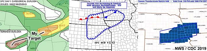
June 25 was one of the last chase days of this chase segment, with activity observed in south-central to SE Nebraska. As many chases before on this trip, an enhanced area was issued by the SPC at 1630z, and is shown in the left image above. A 5% tornado probability is also shown, and my target area is annotated. In the middle and right images is Mesoscale Discussion 1243 and severe thunderstorm watch 444 valid until 10 PM CDT, respectively.
Posted: Jul 19, 2019, 3:35 PM
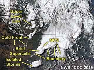
Chris Collura added a new photo.
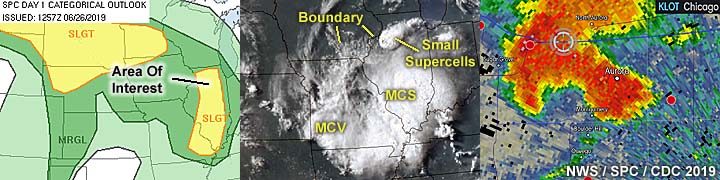
June 26 was a travel day wrapping up this chase trip segment with a drive to spend some time in Chicago. At the end of the day, a severe thunderstorm was intercepted late the day in the western Chicago suburbs. In the images above, the 13z SPC outlook is shown to the left, showing a large slight risk area over the northern Plains and a separate more conditional slight risk over Illinois. The "impromptu" target area is denoted by the annotation in the left image. No Mesoscale Discussions nor watch boxes were valid for this area as per SPC. The middle image shows a visible satellite image of my area of interest near 23z and is annotated showing important features. Note the large MCS of strong thunderstorms ahead of an MCV (mesoscale convective vortex) extending across the Saint Louis area. To the far north are some transient supercell storms causing severe weather over northern Illinois, one of which I observed this day. The right image above is a base reflectivity image out of Chicago, showing a prominent "hook" and intense precipitation core (large hail) as the storm was over the western Chicago suburbs (my indicator is the blue cross hairs). No tornadoes were produced by this storm (mainly large hail and high winds).
Posted: Jul 19, 2019, 3:35 PM
Chris Collura added a new photo.
View of the top of a severe warned storm over the Chicago area late in the day on June 28. The storm is about 25 miles away and the view is towards the south and southwest.Place: Harwood Heights, Illinois (41.9662, -87.8056) Address: Harwood Heights, Illinois 60706
Posted: Jul 19, 2019, 3:35 PM
Chris Collura added a new photo.
While staying in the Chicago area, I managed to get the rear window of the chase vehicle replaced (damaged from the June 21 storm near NE Colorado / W Kansas).Place: Wheaton, Illinois (41.8655, -88.1066) Address: Wheaton, Illinois 60187, 60189
Posted: Jul 19, 2019, 3:35 PM
Chris Collura added a new photo.

While beginning the long drive back to California and passing through Nebraska on I-80, a distant supercell can be seen looming over the horizon on a confluence axis late in the day on July 8. The storm is to the lower right and is roughly 40 miles away and developing along a confluence axis oriented NW to SE. A very brief tornado was reported with this storm. The view is to the southwest.Place: Henderson, Nebraska (40.779166666667, -97.811944444444) Address: Henderson, Nebraska 68371
Posted: Jul 19, 2019, 3:35 PM
Chris Collura added a new photo.
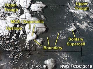
This is an annotated visible satellite image of storms developing late in the day on June 23, 2019. The annotation shows important features and the line of storms / brief supercells can be seen over north-central Texas as of 23z.
Posted: Jul 19, 2019, 3:35 PM
Chris Collura added a new photo.

Passing a powerful strong and severe MCS of storms, this beautiful shelf cloud can be seen over central Nebraska late in the day on July 8 headed west on I-80. The view is to the northwest.Place: Overton, Nebraska (40.7396, -99.5374) Address: Overton, Nebraska 68834, 68863
Posted: Jul 19, 2019, 3:35 PM
Chris Collura added a new photo.
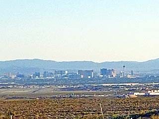
View of Las Vegas, Nevada late in the day on July 10 (while passing through Utah, Arizona, and Nevada on I-15), with desert temperatures approaching 110 deg F ... Almost to California!Place: Apex, Nevada (36.3292, -114.927) Address: Apex, Nevada
Posted: Jul 19, 2019, 3:35 PM
Chris Collura added a new photo.

View of flying tree debris and strong winds associated with the eastern side of a possible rain-wrapped tornado while racing southeast out of Greenville, Texas during the afternoon of June 19. The view is to the southeast. Note the chase tour van stopped to the right. Winds are gusting over 70 MPH here.
Posted: Jul 19, 2019, 3:35 PM
Chris Collura added a new photo.
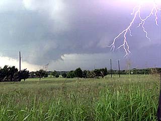
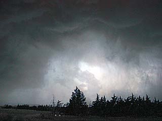
Intense lightning and rotating wall cloud as the storm intensifies and begins rotating west of Greenville, Texas on June 19.
Posted: Jul 19, 2019, 3:35 PM
Chris Collura added a new photo.

It was an awesome pleasure meeting up with Dr Jason Persoff, left, and veteran chaser Dave Hoadley, right, literally "under the meso" while headed back east to the northwest of Limon, Colorado late in the day on June 21. Thanks to Dave Hoadley for sharing this picture of myself (center) and us! Dave has been out chasing more (and longer) than any other storm chaser to this day.
Posted: Jul 19, 2019, 3:35 PM
Chris Collura added a new photo.
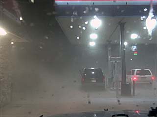
Dust, hail, and small rocks are kicked up in two powerful micro-bursts (the first being dry, and the second loaded with rocks and hail) at a gas station in Sharon Springs, Kansas after dusk on June 21. The second "derecho" surge of straight-line winds gusted near 100 MPH blowing out windows on many vehicles parked at the gas station. The rear window on my Jeep was blown out from the sand / rocks, with even the screen on my phone, mounted on the dash board, broken! Rocks and sand were all over my vehicle, and the front window was cracked and mirrors pitted.
Posted: Jul 19, 2019, 3:35 PM
Chris Collura added a new photo.

View of another chaser's vehicle with all the windows blown out. The storm has passed and is moving into Kansas leaving the power out, hail covering the ground, and damage in Sharon Springs after dark on June 21. Luckily no one was seriously hurt in this.
Posted: Jul 19, 2019, 3:35 PM
Chris Collura added a new photo.
Intense rotation, looking up, and close to producing a tornado, with a small supercell storm east of Clay Center, Kansas before being undercut by outflow on May 28.
Posted: Jul 19, 2019, 3:35 PM
Chris Collura added a new photo.
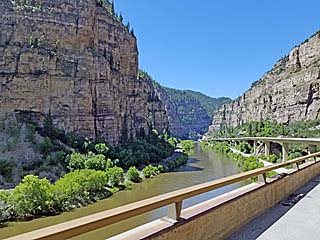
While continuing west to California, many awesome views of the American deserts and southwest were passed. This is a view of the Colorado river and canyon country in central and western Colorado while headed west on I-70 between Denver and Grand Junction on July 10.Place: Dotsero, Colorado (39.6497, -107.06) Address: Dotsero, Colorado 81637
Posted: Jul 19, 2019, 3:35 PM
Chris Collura added a new photo.
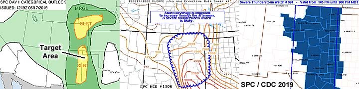
June 17 was a very marginal and conditional chase day with my target area in the western Texas big bend / New Mexico border. This area was in a slight risk outlook as per the 13z and 1630z SPC discussions, as well as another area farther north and out of reach in eastern Colorado. The annotated 13z SPC outlook is shown in the left image, with my target area for the day annotated. To the middle and right is Mesoscale Discussion 1106 and severe thunderstorm watch box 391 valid until 9 PM MDT (10 PM CDT), respectively.
Posted: Jul 19, 2019, 3:35 PM
Chris Collura added a new photo.

Base reflectivity radar image of strong and severe storms in a line / cluster over north-central Texas and near Clay County on June 23. The upper-left inset shows an area of rotation within the cluster of storms (embedded HP supercell).
Posted: Jul 19, 2019, 3:35 PM
Chris Collura added a new photo.
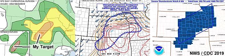
June 22 was a decision day to choose between storm chasing target areas, one in west-central Oklahoma to south-central Kansas, and another in eastern and southeastern Colorado. The former chosen for better instability and chase prospects. In the left image, I am targeting the SW portion of an enhanced risk area (13z) in western Oklahoma. This area also had a 5% tornado probability (in the inset) and annotated showing my target area. In the middle and right images, Mesoscale Discussion 1198 and severe thunderstorm watch box 426, valid until 10 PM CDT, respectively.
Posted: Jul 19, 2019, 3:35 PM
Chris Collura added a new photo.
This is a visible satellite image of the synoptic environment as of 22z on June 18, 2019. Important features are annotated with a mesoscale convective vortex crossing Kansas and a surface boundary providing the stream-wise vorticity for a tornadic supercell storm.
Posted: Jul 19, 2019, 3:35 PM
Chris Collura added a new photo.
Developing intense progressive derecho (destructive straight-line winds) with an impressive shelf cloud / rotating head of the bow segment around dusk on June 21 just west of the KS / CO border. The view is to the northwest.Place: Weskan, Kansas (38.8667, -101.964) Address: Weskan, Kansas 67762
Posted: Jul 19, 2019, 3:35 PM
Chris Collura added a new photo.

June 18 was another long chase day but was awarded with two brief tornadoes on south-central / central Kansas that were the only tornadoes in the target area that day. In the images above, the 13z tornado probability is shown as per SPC to the left, with the enhanced risk areas shown in the inset to the lower left. To the middle and right is Mesoscale Discussion 1116 and tornado watch box 935 valid until 10 PM CDT, respectively for my target area in Kansas.
Posted: Jul 19, 2019, 3:35 PM
Chris Collura added a new photo.

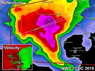
Base reflectivity radar image of a tornadic HP supercell storm as it neared Greenville, Texas late in the day on June 19. The storm has a prominent "hook echo" forming on its SE side and a velocity couplet in the upper-right inset.
Posted: Jul 19, 2019, 3:35 PM
Chris Collura added a new photo.

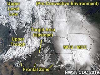
This is a visible satellite image of the pre-convective environment near the target area during the 18z time frame on June 19, 2019. The annotated image shows the synoptic features of the setup, with a developing field of agitated / towering cumulus along a convergence area / boundary in north-central to NE Texas.
Posted: Jul 19, 2019, 3:35 PM
Chris Collura added a new photo.
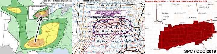
June 19 was another chase day in northeastern Texas, with a tornado warned supercell with a rain-wrapped tornado intercepted late in the day. In the images above, the 1630z SPC enhanced risk outlook is shown with a large slight risk area humorously forming a "swan" shape over much of the county. The inset shows my target area and annotation, with a 10% probability of tornadoes. In the middle and right images is Mesoscale Discussion 1136 and tornado watch box 401 for a large area valid until 12 AM CDT the following day, respectively.
Posted: Jul 19, 2019, 3:35 PM
Chris Collura added a new photo.
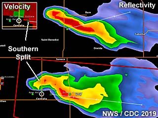
Annotated base reflectivity image of two supercell storms over NE Kansas on June 20 during the early evening. This originally was a single storm that split into two, with the most intense supercell being the southern storm. The velocity image is in the upper-left inset. If you look closely at the "left split" of the storm to the north, it has a slight anticyclonic "curl" in its reflectivity on the western end (clockwise)!
Posted: Jul 19, 2019, 3:35 PM
Chris Collura added a new photo.
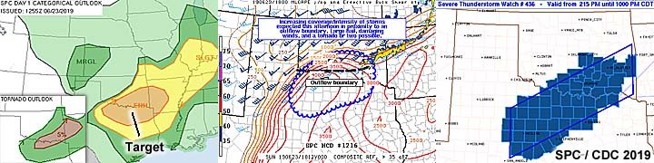
June 23 was another seemingly good chase day that turned out to be only outflow dominant / squall line type storms in north-central Texas. In the images above, the 13z SPC outlook is shown, with an enhanced risk and my target area annotated. A 5% tornado probability is indicated as well in the lower left inset. In the middle and right images, is Mesoscale Discussion 1216 and severe thunderstorm watch box 436, valid until 10 PM CDT, respectively.
Posted: Jul 19, 2019, 3:35 PM
Chris Collura added a new photo.
Annotated visible satellite from near 23z on June 20, 2019. The important features of the synoptic environment are denoted, such as boundaries and a solitary LP supercell storm over NE Kansas.
Posted: Jul 19, 2019, 3:35 PM
Chris Collura added a new photo.
This is a base reflectivity image of a tornadic supercell storm developing over the Palmer Divide area near Kiowa, Colorado on June 21. The hook is prominent and the storm velocity image is the lower-left inset. A weak tornado was observed at this time (the white circle being my GPS location).
Posted: Jul 19, 2019, 3:35 PM
Chris Collura added a new photo.
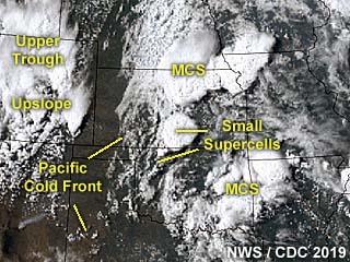
This is a visible satellite image of the pre-convective environment near the target area during the 18z time frame on June 21, 2019. The annotated image shows the synoptic features of the setup, with my area targeting the up-slope expected in Colorado. The large messy complex of storms (to the east / right in the image) is of no interest to storms chasing in this case.
Posted: Jul 19, 2019, 3:35 PM
Chris Collura added a new photo.

Base reflectivity image of an HP supercell evolving to a line segment / bow that will produce very large hail and 100 MPH wind gusts (note the RIJ / rear inflow jet!) as it crosses from NE Colorado and into Kansas on June 21. The lower-right inset shows the intense velocity of the storm as it "gusts out" and produced extreme damaging winds.
Posted: Jul 19, 2019, 3:35 PM
Chris Collura added a new photo.
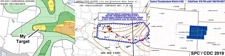
June 21 was a chase day that ended up with two powerful supercells intercepted in Colorado, one producing a brief tornado, and ending up with damage to my vehicle from extreme winds just east of the border in Sharon Springs, Kansas. The target area for the day was eastern and northeastern Colorado, starting with up-slope / Palmer Divide area targets. In the left image above, the annotated slight risk is shown as per the SPC 13z outlook. Little interest was given to the enhanced risk father east nor other areas. The middle image is Mesoscale Discussion 1181 relevant to my target area and shows the general setup. To the right are severe thunderstorm watch boxes 417 and 420, valid until 8 PM MDT and 11 PM MDT, respectively. Watch 420 is the main one in the image, but the one outlined to its left is box 417.
Posted: Jul 19, 2019, 3:35 PM
Chris Collura added a new photo.

Base reflectivity radar image, and upper left inset showing velocity, of a small / transient supercell storm over Major County, Oklahoma late in the day on June 22.
Posted: Jul 19, 2019, 3:35 PM
Chris Collura added a new photo.
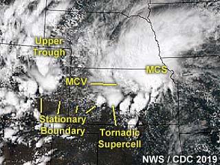
This is an annotated visible satellite image of storms developing late in the day on June 22, 2019 around 23z. This is a highly complex setup, and the image is annotated to point out important features such as boundaries and troughs.
Posted: Jul 19, 2019, 3:35 PM
Chris Collura added a new photo.

June 20 was supposed to be a travel day only, but turned out to be a chase day with a beautiful supercell storm observed in northeastern Kansas by late afternoon. In the images above, the area chased (conditional target) is annotated on the large slight risk outlook issued by the SPC at 1630z. Mesoscale Discussion 1168 is shown in the middle image, mainly issued for the area around the solitary supercell storm intercepted. The SPC slight-risk area also had a tornado probability of 5%, which is annotated (showing my target area) and shown in the right image (no watches were issued for this area due to the conditional nature of the setup).
Posted: Jul 19, 2019, 3:35 PM
Chris Collura added a new photo.
Powerful bow segment evolving from an HP supercell undergoing upscale growth and passing from NE Colorado into western Kansas during the evening of June 21. Rear inflow jet mentioned in the radar analysis can be seen visually looking south in this image (just above the power poles) kicking up dust.Place: Arapahoe, Colorado (38.85, -102.182) Address: Arapahoe, Colorado 80802
Posted: Jul 19, 2019, 3:35 PM
Chris Collura added a new photo.

View of the supercell storm moving east and southeast towards Limon, Colorado on June 21 from the Cedar Point exit off I-70. The storm is now a major hail threat at this point.Place: Agate, Colorado (39.4619, -103.942) Address: Agate, Colorado 80101
Posted: Jul 19, 2019, 3:35 PM
Chris Collura added a new photo.
Hail covers the roadway just behind the weakening supercell storm to the southwest of Limon, Colorado on June 21.Place: Limon, Colorado (39.2643, -103.69) Address: Limon, Colorado 80826, 80828
Posted: Jul 19, 2019, 3:35 PM
Chris Collura added a new photo.
Base reflectivity image of Tipton / Beloit, Kansas supercell during the afternoon of May 28. The inset shows the Doppler velocity of the storm.
Posted: Jul 19, 2019, 3:35 PM
Chris Collura added a new photo.
Annotated satellite image showing convective evolution and the synoptic setup during the afternoon of May 28, 2019. Tornadic supercells have formed to the southwest of Kansas City (with a destructive rain-wrapped tornado near Lawrence) as well as farther west in north-central, Kansas - Which produced highly photogenic and visible tornadoes near Tipton.
Posted: Jul 19, 2019, 3:35 PM
Chris Collura added a new photo.
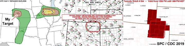
May 27 was a better chase day, with a nice post-frontal / up-slope setup in northeastern Colorado, with some tornadoes observed and not plagued by storms developing before even finishing lunch! In the left image above, the SPC had two enhanced risk outlooks, one over NE Colorado, and another way east and out of reach near Illinois. In the image, the tornado probabilities are shown as per the 13z SPC outlook, with the objective target area pointed out in the 5% area. The 10% significant far and distant tornado risk area to the east (northern Illinois) was not applicable for this chase day. The middle image shows Mesoscale Discussion 833 for the main target area. Tornado watch box 264, valid until 9 PM MDT is shown to the right.
Posted: Jul 19, 2019, 3:35 PM
Chris Collura added a new photo.
Annotated satellite image showing convective evolution and the synoptic setup during the afternoon of May 27, 2019. The supercell storms of interest are in an area anywhere from Fort Morgan, Colorado, and eastward through Holyoke and near Imperial, Nebraska late in the period.
Posted: Jul 19, 2019, 3:35 PM
Chris Collura added a new photo.
Base reflectivity image of the main and powerful supercell moving out of northeast Colorado during the afternoon of May 27, and near Imperial, Nebraska. The inset shows the Doppler velocity of the storm, which was producing tornadoes and sporting a striking visual appearance at the time.
Posted: Jul 19, 2019, 3:35 PM
Chris Collura added a new photo.
May 30 was a travel day, with a drive from Iowa City to Chicago for down time. In this image, a small (non-severe) convective shower hangs over Aurora, IL during the early afternoon of May 30, 2019.Place: Waterman, Illinois (41.7708, -88.7747) Address: Waterman, Illinois 60556
Posted: Jul 19, 2019, 3:35 PM
Chris Collura added a new photo.

A nearly deadly accident occurred at the intersection of Highway 183 and I-40 in Clinton, Oklahoma with a mangled vehicle on fire with the tornadic storm grazing the area to the north. EMS and myself managed to drag the woman and her two children out of the vehicle before fire consumed it.Place: Clinton, Oklahoma (35.5094, -98.9741) Address: Clinton, Oklahoma 73601
Posted: Jul 19, 2019, 3:35 PM
Chris Collura added a new photo.

Base reflectivity image of the Kansas City / Lawrence, Kansas supercell during the afternoon of May 28. Note the prominent "swirl" in the reflectivity, denoting a highly rain-wrapped HP supercell tornado. To the right are two insets, with the distinct correlation-coefficient showing debris (blue) to the top, as well as extreme Doppler velocities on the bottom inset.
Posted: Jul 19, 2019, 3:35 PM
Chris Collura added a new photo.
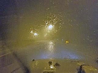
Extremely heavy rains and winds gusting near 90 MPH impacts Clinton, Oklahoma during the evening of June 15 as the powerful MCS catches up with the tornadic HP storm to the north.
Posted: Jul 19, 2019, 3:35 PM
Chris Collura added a new photo.

The LP supercell and it's RFD produces this nice low wall cloud before weakening to the northwest of Santa Anna, Texas on June 16.Place: Coleman, Texas (31.8278, -99.4256) Address: Coleman, Texas 76834
Posted: Jul 19, 2019, 3:35 PM
Chris Collura added a new photo.
Here is a view of the WP-3 "Orion" aircraft (for the TORUS research project) flying overhead as the storm weakens with another distant supercell to the south as the back-drop as of late afternoon on June 16.Place: Thrifty, Texas (31.81149983018, -99.133617703679) Address: Thrifty, Texas
Posted: Jul 19, 2019, 3:35 PM
Chris Collura added a new photo.

Small mid-high level shear funnel and rotation area on the weakening LP supercell near Davenport, Nebraska during the afternoon on June 25.
Posted: Jul 19, 2019, 3:35 PM
Chris Collura added a new photo.

Picture of myself in a field of wild flowers while waiting for late afternoon storms to organized on June 16.Place: Burkett, Texas (31.99779, -99.22552) Address: Burkett, Texas
Posted: Jul 19, 2019, 3:35 PM
Chris Collura added a new photo.
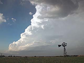
Intensifying low-precipitation / classic supercell northwest of Santa Anna (over Callahan County), Texas during the afternoon of June 16.Place: Burkett, Texas (31.99779, -99.22552) Address: Burkett, Texas
Posted: Jul 19, 2019, 3:35 PM
Chris Collura added a new photo.

The shortwave trough moves by and the clear "dry punch" of air ends the day on June 16 by early evening.Place: Tuscola, Texas (32.2091, -99.7971) Address: Tuscola, Texas 79562
Posted: Jul 19, 2019, 3:35 PM
Chris Collura added a new photo.

Passing through a severe cluster of late morning / early afternoon storms on June 16 near Albany, Texas. The storms contained hail to golfball sized. The hail shaft is visible to the left.Place: Fort Griffin, Texas (32.9319, -99.2297) Address: Fort Griffin, Texas
Posted: Jul 19, 2019, 3:35 PM
Chris Collura added a new photo.
Hail stones from the LP storm near Muleshow, Texas during the afternoon of June 17.
Posted: Jul 19, 2019, 3:35 PM
Chris Collura added a new photo.

May 28 was a frustrating chase day with multiple targets requiring no "hesitation" once storms developed. The primary target area was from Topeka and eastward. In the SPC image to the left, a 10% tornado outlook is shown as per their 1630z moderate risk outlook. The middle image is Mesoscale Discussion 853. To the right are tornado watch boxes 275 and 276, both valid until 10 PM CDT. Hesitant decisions and straying too far from my target area caused me to miss tornadoes today.
Posted: Jul 19, 2019, 3:35 PM
Chris Collura added a new photo.

Annotated satellite image showing convective evolution and the synoptic setup during the afternoon of May 29, 2019. The main area chased was in eastern Iowa, owing to a cold-occlusion and "cold-core" environment east of a surface low.
Posted: Jul 19, 2019, 3:35 PM
Chris Collura added a new photo.
First view of the "tail-end" supercell to the north of Putnam, Oklahoma late on June 15. This is the "classic" mode of this storm before evolving to HP (high precipitation) mode and is already tornado-warned at this time.Place: Fay, Oklahoma (35.81248, -98.65455) Address: Fay, Oklahoma
Posted: Jul 19, 2019, 3:35 PM
Chris Collura added a new photo.

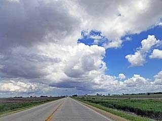
Storms initiate and quickly become severe in NW to Central Oklahoma during the late afternoon of June 15.Place: Lahoma, Oklahoma (36.388055555556, -98.088888888889) Address: Lahoma, Oklahoma 73754
Posted: Jul 19, 2019, 3:35 PM
Chris Collura added a new photo.
While waiting form storms to develop, I met up with Dan Shaw and a few other storm chasers in Wakita, Oklahoma and visited the Twister Museum during the afternoon of June 15. I am standing in front of one of the faux "tornado probes" called "Dorothy" used in the movie from 1996.Place: Wakita, Oklahoma (36.881666666667, -97.923888888889) Address: Wakita, Oklahoma 73771
Posted: Jul 19, 2019, 3:35 PM
Chris Collura added a new photo.
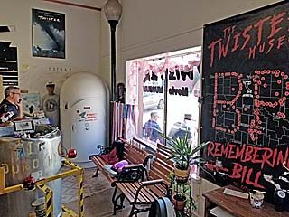
Another view of the Twister Museum in Wakita, Oklahoma during the afternoon of June 15. Note the tornado shelter and "Bill Paxton" memorial as portrayed on Spotter Network.Place: Wakita, Oklahoma (36.881666666667, -97.923888888889) Address: Wakita, Oklahoma 73771
Posted: Jul 19, 2019, 3:35 PM
Chris Collura added a new photo.

Another view (lightning illuminated) of the tornado west of Custer City, Oklahoma after dark on June 15.
Posted: Jul 19, 2019, 3:35 PM
Chris Collura added a new photo.

Large truncated wedge / cone tornado illuminated by lightning appears in the lower left of this picture taken west of Custer City, Oklahoma after dark on June 15. The view is to the northwest towards Putnam.
Posted: Jul 19, 2019, 3:35 PM
Chris Collura added a new photo.

Strong outflow, or even a heat burst (temperatures go up in a dry downdraft) to the northeast of Manter, Kansas on June 14.Place: Johnson, Kansas (37.5706, -101.751) Address: Johnson, Kansas
Posted: Jul 19, 2019, 3:35 PM
Chris Collura added a new photo.

May 29 was both a marginal chase day and travel day, since I was already en-route to Chicago for down time during the succeeding days. Despite a large enhanced area to the far south and east (with a 10% tornado area in SE Texas and well out of reach), I decided on the "cold-core" setup in eastern Iowa, which had a 2% tornado outlook as per SPC at 1630z. The tornado probabilities and my target area are shown to the left. Both produced significant tornadoes. The middle image shows Mesoscale Discussion 882 for the far and distant SE Texas target. To the right, is Mesoscale Discussion 885 for my area targeted in eastern Iowa (no watch was issued there).
Posted: Jul 19, 2019, 3:35 PM
Chris Collura added a new photo.
Funnel / mesocyclone of high-based supercell storm with RFD dust during the late afternoon of June 14 to the north of Manter, Kansas near the Colorado / Kansas border.Place: Manter, Kansas (37.52417, -101.88444) Address: Manter, Kansas 67862
Posted: Jul 19, 2019, 3:35 PM
Chris Collura added a new photo.
Maturing low-precipitation (LP) high-based supercell near the CO / KS border during the afternoon of June 14.Place: Campo, Colorado (37.1047, -102.578) Address: Campo, Colorado 81029
Posted: Jul 19, 2019, 3:35 PM
Chris Collura added a new photo.
Strong and severe storms initiating west of the KS / CO border during the afternoon of June 14.Place: Johnson, Kansas (37.5706, -101.751) Address: Johnson, Kansas
Posted: Jul 19, 2019, 3:35 PM
Chris Collura added a new photo.
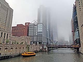
View of the Chicago River in downtown Chicago during some down-time spent in that area on a foggy cool afternoon.Place: Chicago, Illinois (41.883222, -87.632496) Address: Chicago, Illinois
Posted: Jul 19, 2019, 3:35 PM
Chris Collura added a new photo.

Here is a view of the Lincoln Park area (near the zoo) While I was staying in the Chicago area.Place: Chicago, Illinois (41.883222, -87.632496) Address: Chicago, Illinois
Posted: Jul 19, 2019, 3:35 PM
Chris Collura added a new photo.
This is a strong to severe thunderstorm complex near Janesville, Wisconsin on June 1, 2019. This storm contained strong winds near 60 MPH and large hail (hail shaft is to the left in this picture).
Posted: Jul 19, 2019, 3:35 PM
Chris Collura added a new photo.
Doppler (base reflectivity) radar image of a tornadic supercell west of Iowa City and near Williamsburg, Iowa late in the day on May 29. The inset shows the intense Doppler velocity as well as my position in the blue cross-hair circle.
Posted: Jul 19, 2019, 3:35 PM
Chris Collura added a new photo.

Gustnado along the high-based storm outflow near Manter, Kansas late in the afternoon of June 14.Place: Manter, Kansas (37.52417, -101.88444) Address: Manter, Kansas 67862
Posted: Jul 19, 2019, 3:35 PM
Chris Collura added a new photo.
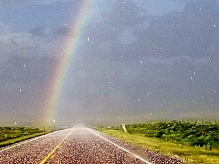
Beautiful view of an intense rainbow (or "hail-bow") while racing eastward past Kit Carson, Colorado with hail up to golfball sized falling in the foreground during the early evening of June 21.Place: Kit Carson, Colorado (38.7639, -102.794) Address: Kit Carson, Colorado 80825
Posted: Jul 19, 2019, 3:35 PM
Chris Collura added a new photo.
A funnel cloud develops on the updraft on the SW portion of the LP supercell storm down-scaling to the northwest of Santa Anna, Texas on June 16.
Posted: Jul 19, 2019, 3:35 PM
Chris Collura added a new photo.
Low precipitation supercell storm near Muleshow, Texas during the afternoon of June 17 as it was producing large hail to at least 1.5".Place: Parmerton, Texas (34.5797, -102.802) Address: Parmerton, Texas
Posted: Jul 19, 2019, 3:35 PM
Chris Collura added a new photo.

Many people think Kansas City is the capitol of Kansas. It is not, and plus Kansas City is in Missouri as well with Jefferson City as its capitol. In this picture, the Kansas capitol building of Topeka is shown, which is west of Kansas City, while driving by on June 24 / 25.Place: Topeka, Kansas (39.0392, -95.6895) Address: Topeka, Kansas 66601
Posted: Jul 19, 2019, 3:35 PM
Chris Collura added a new photo.
Wall cloud rotating on the southwestern supercell to the SW of Kiowa, Colorado on June 21. Note the impressive shelf cloud extending to the right with the rotating portion lowering to its left in the center of the picture.
Posted: Jul 19, 2019, 3:35 PM
Chris Collura added a new photo.
Close up of rotating wall cloud and brief tornado, denoted by dust on the ground, southwest of Kiowa, Colorado on June 21.
Posted: Jul 19, 2019, 3:35 PM
Chris Collura added a new photo.

Initiation of a supercell storm north of Manhattan, Kansas late in the afternoon of June 20. This will develop into a beautiful LP (low precipitation) supercell storm near Nemaha County, Kansas.Place: Zeandale, Kansas (39.1594, -96.4264) Address: Zeandale, Kansas
Posted: Jul 19, 2019, 3:35 PM
Chris Collura added a new photo.
View of developing LP supercell storm near Nemaha County, Kansas on June 20.Place: Blaine, Kansas (39.496681395833, -96.400944891667) Address: Blaine, Kansas
Posted: Jul 19, 2019, 3:35 PM
Chris Collura added a new photo.

View of intensifying (and beautiful) LP supercell storm over Nemaha County, Kansas. Note the small wall cloud too! The view is to the west.Place: Centralia, Kansas (39.7242, -96.1311) Address: Centralia, Kansas 66415
Posted: Jul 19, 2019, 3:35 PM
Chris Collura added a new photo.

Wide-angle view of LP supercell storm over Nemaha County, Kansas. The view is to the west.Place: Kelly, Kansas (39.7378, -96.0031) Address: Kelly, Kansas
Posted: Jul 19, 2019, 3:35 PM
Chris Collura added a new photo.
View of a funnel cloud on a rotating wall cloud to the west of Greenville, Texas during the afternoon of June 19.
Posted: Jul 19, 2019, 3:35 PM
Chris Collura added a new photo.
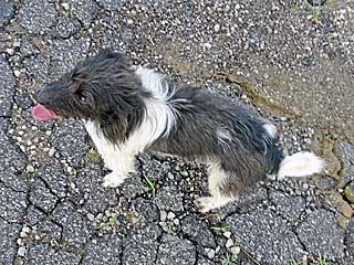
While pulled over and watching the LP supercell to my west, this little furry animal (probably a farmer's dog from a nearby ranch) comes out of nowhere and joins me watching the storm!Place: Kelly, Kansas (39.7378, -96.0031) Address: Kelly, Kansas
Posted: Jul 19, 2019, 3:35 PM
Chris Collura added a new photo.

Who could resist? I just take a humorous selfie of myself as if I am holding up a stack of plates! This was as the LP supercell over Nemaha County, Kansas started weakening / down-scaling during the evening of June 20.Place: Netawaka, Kansas (39.6032, -95.7188) Address: Netawaka, Kansas 66516
Posted: Jul 19, 2019, 3:35 PM
Chris Collura added a new photo.
Rapidly approaching extreme / damaging (XDW) straight-line winds looking west from near Sharon Springs, Kansas at gas station after dusk on June 21. It does not look like much here, but winds gusting near or over 100 MPH are rapidly approaching from the west.
Posted: Jul 19, 2019, 3:35 PM
Chris Collura added a new photo.

Storms begin initiating near the Palmer Divide in Colorado. This view is looking west from northwest of Limon, Colorado near Cedar Point off I-70 while targeting storms developing between Castle Rock and Kiowa, Colorado during the afternoon of June 21.Place: Agate, Colorado (39.4619, -103.942) Address: Agate, Colorado 80101
Posted: Jul 19, 2019, 3:35 PM
Chris Collura added a new photo.
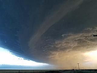
A large supercell storm can be seen with a low rotating base and shelf / wall cloud near Kiowa, Colorado on June 21.Place: Kiowa, Colorado (39.3442, -104.463) Address: Kiowa, Colorado 80117
Posted: Jul 19, 2019, 3:35 PM
Chris Collura added a new photo.

View looking north at the main updraft and HP storm mesocyclone after dusk on June 15 in Custer County, OK.Place: Custer City, Oklahoma (35.6655, -98.8851) Address: Custer City, Oklahoma 73639
Posted: Jul 19, 2019, 3:35 PM
Chris Collura added a new photo.

Another view of a brief tornado (dust under non-condensed rotation) southwest of Kiowa, Colorado on June 21.
Posted: Jul 19, 2019, 3:35 PM
Chris Collura added a new photo.
Low precipitation supercell storm over Nemaha County, Kansas during the early evening of June 20. The distant "left split" can be seen to the far lower right.Place: Corning, Kansas (39.6564, -96.0303) Address: Corning, Kansas 66417
Posted: Jul 19, 2019, 3:35 PM
Chris Collura added a new photo.

Approaching an LP (low precipitation) supercell with mammatus and anvil blow-off overhead in the western Texas Panhandle during the afternoon of June 17. The developing LP storm base is to the lower right in this view towards the southwest.Place: Parmerton, Texas (34.5797, -102.802) Address: Parmerton, Texas
Posted: Jul 19, 2019, 3:35 PM
Chris Collura added a new photo.
Closer view of the left-moving northern split of the LP supercell that is anticyclonic and moving away to the northeast late on June 20. Note the impressive bulk shear and tilting of the updraft.
Posted: Jul 19, 2019, 3:35 PM
Chris Collura added a new photo.
Looking back west into the "notch" of the HP supercell where a large wall cloud can be seen. A brief view of a possible large rain-wrapped tornado was also spotted by Roger Hill's tour group from this location late on June 19.Place: Seymore, Texas (32.9908, -95.5953) Address: Seymore, Texas
Posted: Jul 19, 2019, 3:35 PM
Chris Collura added a new photo.
Closeup view of updraft base of the LP supercell storm on June 17 near Muleshow, Texas.Place: Muleshoe, Texas (34.2278, -102.729) Address: Muleshoe, Texas 79347
Posted: Jul 19, 2019, 3:35 PM
Chris Collura added a new photo.
Passing into Kansas north of Clearwater and the clouds associated with an MCV (mesoscale convective vortex) and surface boundary can be seen looming over the horizon.Place: Selman, Oklahoma (36.8019, -99.4906) Address: Selman, Oklahoma
Posted: Jul 19, 2019, 3:35 PM
Chris Collura added a new photo.

The chase is on! In the distance, a developing supercell can be seen looking northwest of Greensburg, Kansas on June 18. This storm will quickly become severe and produce some brief tornadoes later near Kinsley.Place: Buttermilk, Kansas (37.1028, -99.325) Address: Buttermilk, Kansas
Posted: Jul 19, 2019, 3:35 PM
Chris Collura added a new photo.
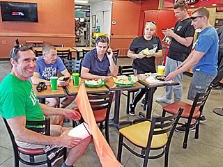
Meeting up with Dan Shaw (center on the phone) and Greg Ansel (left) with several other chasers for a quick fuel stop in Greensburg, Kansas and grabbing a quick subway sandwich to go as a nice storm was already developing to our northwest and becoming severe warned. Greg Ansel is also holding a storm "probe" of some sort he found with a parachute attached (maybe Reed Timmer's)?Place: Greensburg, Kansas (37.6044, -99.2936) Address: Greensburg, Kansas 67054
Posted: Jul 19, 2019, 3:35 PM
Chris Collura added a new photo.

Approaching a tornadic supercell (about 10 to 15 miles away) near Kinsley, Kansas during the afternoon of June 18. The view is towards the northwest and a tornado is visible on the ground just to the right of the lower-center of the picture.Place: Kinsley, Kansas (37.9222, -99.4117) Address: Kinsley, Kansas 67547
Posted: Jul 19, 2019, 3:35 PM
Chris Collura added a new photo.

View of wall cloud as the storm moves north of Kinsley, Kansas on June 18. The view is to the north.Place: Kinsley, Kansas (37.9222, -99.4117) Address: Kinsley, Kansas 67547
Posted: Jul 19, 2019, 3:35 PM
Chris Collura added a new photo.
View of formerly tornadic supercell storm east of Kinsley, Kansas on June 18. Looking west, the wall cloud and updraft structure can be seen.Place: Belpre, Kansas (37.9511, -99.0997) Address: Belpre, Kansas 67519
Posted: Jul 19, 2019, 3:35 PM
Chris Collura added a new photo.
The storm continues to the southeast and weakens / evolves to an MCS via upscale growth. The view of the backside of the updraft can be seen late in the day on June 19. The view is to the southeast.Place: Brashear, Texas (33.11881, -95.73435) Address: Brashear, Texas
Posted: Jul 19, 2019, 3:35 PM
Chris Collura added a new photo.

Another supercell storm developed west of Wichita, but evolved to an MCS and became quickly undercut by outflow late in the day on June 18. The view here is to the east and northeast.Place: Belmont, Kansas (37.5236, -97.9889) Address: Belmont, Kansas
Posted: Jul 19, 2019, 3:35 PM
Chris Collura added a new photo.

Closer view of a brief tornado on the ground (from a distance of 5 to 10 miles) while closing in on a classic supercell storm near Kinsley, Kansas during the afternoon of June 18.
Posted: Jul 19, 2019, 3:35 PM
Chris Collura added a new photo.
Convective initiation over north-central to northeastern Texas late in the day on June 19 as the cap is breached by surface heating.Place: Leonard, Texas (33.3831, -96.2453) Address: Leonard, Texas 75452
Posted: Jul 19, 2019, 3:35 PM
Chris Collura added a new photo.

A developing supercell storm becomes established west of Greenville, Texas. The view is to the west and the main updraft base is in the center of the photo.Place: Farmersville, Texas (33.1641, -96.3667) Address: Farmersville, Texas 75442
Posted: Jul 19, 2019, 3:35 PM
Chris Collura added a new photo.

A rotating wall cloud / funnel can be seen here as it passes menacingly close to a trailer home west of Greenville, Texas during the afternoon of June 19.Place: Floyd, Texas (33.148611111111, -96.245) Address: Floyd, Texas
Posted: Jul 19, 2019, 3:35 PM
Chris Collura added a new photo.
View of FFD (forward flank downdraft) to the northwest of Greenville, Texas during the afternoon of June 19. The storm is beginning a right turn and starting to move to the SE, with a forward-flank mesocyclone forming. High-end EF-1 tornado damage was reported in Greenville.Place: Greenville, Texas (33.126, -96.1097) Address: Greenville, Texas 75401
Posted: Jul 19, 2019, 3:35 PM
Chris Collura added a new photo.
View looking north at the rain-wrapped circulation (any tornado would be to the far-left in this picture behind the "wet" RFD). This was southeast of Greenville, Texas during on June 19.Place: Miller Grove, Texas (33.0242, -95.8025) Address: Miller Grove, Texas
Posted: Jul 19, 2019, 3:35 PM
Chris Collura added a new photo.
A distant supercell storm can be seen looming in the distance while headed south back into Oklahoma during the early evening of June 18. This storm later became tornado warned west of Tulsa, Oklahoma. The view is to the southeast.Place: Wellington, Kansas (37.2673, -97.4001) Address: Wellington, Kansas 67152
Posted: Jul 19, 2019, 3:35 PM
Chris Collura added a new photo.
RFD clear slot of the Callahan County LP supercell storm on June 16.Place: Coleman, Texas (31.8278, -99.4256) Address: Coleman, Texas 76834
Posted: Jul 19, 2019, 3:35 PM
Chris Collura added a new photo.
Dan Shaw and a few other chasers meeting "under the mesocyclone" during the afternoon of June 16 in Callahan County, Texas.Place: Coleman, Texas (31.8278, -99.4256) Address: Coleman, Texas 76834
Posted: Jul 19, 2019, 2:47 PM
https://youtu.be/7h4JA2jH2DY
Posted: Jul 19, 2019, 2:45 PM
https://www.sky-chaser.com/mwcl2019.htm#EXP19
Posted: Jul 18, 2019, 9:54 PM
Chris Collura commented on Stormtrack's photo.

Posted: Jul 18, 2019, 9:33 PM
Chris Collura commented on Jason Foster's post.
Nice!!!!
Posted: Jul 18, 2019, 9:03 PM
Chris Collura commented on Brian Stertz's post.
Posted: Jul 18, 2019, 8:58 PM
Chris Collura commented on Brad Hannon's photo.
I would take a photogenic landspout over ANY other tornado anytime. Wow. Just wow!
Posted: Jul 18, 2019, 8:55 PM
Chris Collura replied to Jason Foster's comment.
Jason Foster Depends. Maybe you just were lucky and had a good provider. The billing and financial aspect is to hell in a hen basket all around.
Posted: Jul 18, 2019, 8:53 PM
Chris Collura commented on Dave Lewison's post.
I was burned good and hard for an ER visit on a Thanksgiving weekend when everything was closed and severe bursitis in my knee had me crawling.
The medicines were: $20.
The insurance paid: $0.
The 15 minute ER visit: $1567.
Temper tantrum at my mailbox: Priceless...
Posted: Jul 17, 2019, 7:20 PM
Chris Collura commented on Jason Foster's photo.
Dont use these. Period.
The ads alone will be bad enough.
Posted: Jul 17, 2019, 7:19 PM
Chris Collura commented on Dave Lewison's post.
Like the "cashapp" used by prostitutes. No thanks :[
Posted: Jul 16, 2019, 3:56 PM
Chris Collura replied to his own comment.
Nick Nolte At least you're not jailed to flying Spirit. I cannot see myself wearing a weeks worth of shirts and pants to avoid their outrageous carry on fees.
Posted: Jul 16, 2019, 3:54 PM
Chris Collura commented on Regional Entertainment's post.
This is a confirmed hoax and just a FB / internet meme. No one is going over there.
Posted: Jul 16, 2019, 11:56 AM
Chris Collura replied to his own comment.
Nick Nolte That sucks.
Posted: Jul 16, 2019, 11:55 AM
Chris Collura commented on Great Ohio Coaster Club's post.

Posted: Jul 16, 2019, 11:06 AM
Chris Collura commented on Stephen Skelly's post.
I see it :)
Why in jail? What did you do?
Haha
Posted: Jul 16, 2019, 11:05 AM
Chris Collura commented on HIV Medication Injury Claims's post.
Sick of seeing this. No one dies of AIDS anymore because of these drugs. Plus if you read carefully these were about a toxic ingredient that was used until 2017 that has since been removed. Check out the lawsuits for other drugs too and grab some popcorn - Everything today is about SUEing one another. So sad.
Posted: Jul 16, 2019, 8:55 AM
Chris Collura commented on ChaserTV's photo.
Back in 2008 I chased 10 days and spent like $2500 between gas, hotels, food, car rental, airfare, etc. Wound up selling video and making $3500 during that same period. It was sweet but that was 2008.
10+ years later you can only dream of doing that. So dont expect to make anything now UNLESS you film something extreme no one else also got.
Luckily this isnt an issue for me as I always chase not expecting to make anything (but IF I do, great)!
Posted: Jul 16, 2019, 8:39 AM
Chris Collura commented on HIV Medication Injury Claims's post.
More bull shit as it clearly states rare side effects like this might occur in small samples of people taking the drug. I see this with any drug, not just those treating HIV.
Posted: Jul 15, 2019, 7:35 PM
Chris Collura commented on George Kourounis's photo.

Posted: Jul 14, 2019, 9:19 PM
Chris Collura commented on Jim Reed's photo.

Posted: Jul 14, 2019, 9:15 PM
Chris Collura commented on Jason Foster's photo.
Near Clewiston?
Posted: Jul 14, 2019, 9:47 AM
Chris Collura commented on Scott Currens's photo.
Posted: Jul 13, 2019, 8:44 PM
Chris Collura commented on Vinh X Nguyen's photo.
Posted: Jul 13, 2019, 8:42 PM
Chris Collura replied to Alex Carr's comment.
I'm sure ... And with Barry in mind they're having specials on scrambled eggs (only if they are seeing radar / satellite imagery).
Posted: Jul 13, 2019, 8:40 PM
Chris Collura commented on iCyclone's photo.
Welcome to the "15 minute hurricane" of 2019!
Posted: Jul 13, 2019, 8:39 PM
Chris Collura replied to Angel Henderson's comment.
Posted: Jul 13, 2019, 10:39 AM
Chris Collura commented on a live video.
Posted: Jul 13, 2019, 10:37 AM
Chris Collura replied to Jason Foster's comment.
Jason Foster Exactly. Why even bother?
Posted: Jul 13, 2019, 8:08 AM
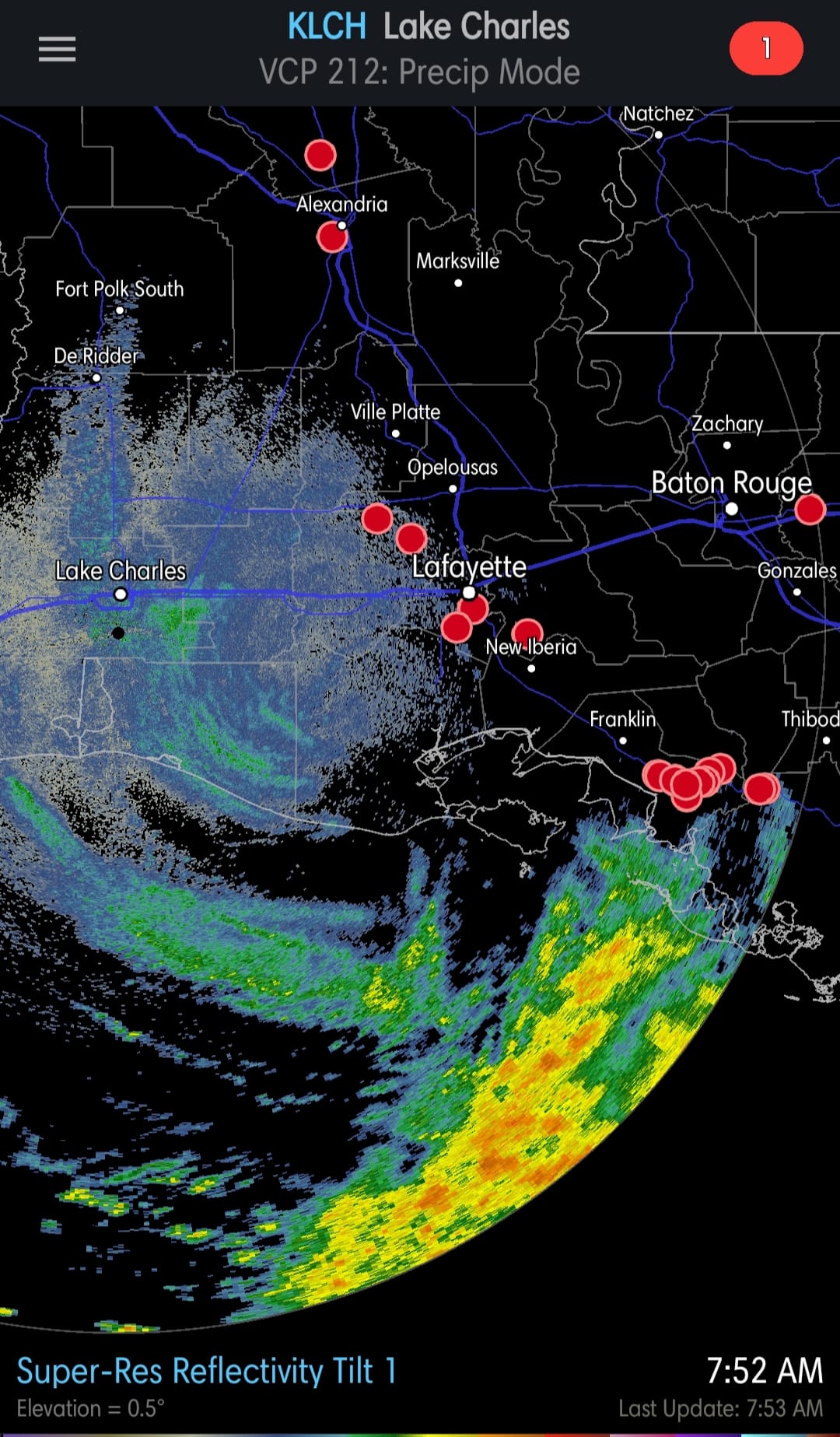
Barry finally becomes the first hurricane of the Atlantic season RIGHT WHEN it is on the Louisiana coast with 75 mph winds. It wont remain a hurricane for long though since the storm is now over land.Plus based on the radar presentation, you would never imagine this is even such. The hurricane forced wind gusts are confined to a small area near the coast and right of the center.
Posted: Jul 13, 2019, 7:43 AM
Chris Collura replied to Rebecca Holliday's comment.
Rebecca Holliday All the Waffle Houses there are open too.
Posted: Jul 13, 2019, 7:41 AM
Chris Collura commented on Nick Nolte's post.
Hopefully you're not flying American Airlines (or else bring books and board games for the delays in DFW)!
Posted: Jul 13, 2019, 7:38 AM
Chris Collura commented on iCyclone's photo.
Wow that radar image is so UN TROPICAL looking. You would think it was a cold front in the winter (if you asked me what it was). I didnt go either.
Posted: Jul 12, 2019, 8:28 PM
Chris Collura commented on Porter County Sheriff's Office's photo.
Wow a true hero saving lives in such a selfless manner. Awesome job! God bless him!
Posted: Jul 12, 2019, 8:26 PM
Chris Collura commented on WXChasing's live video.
That's gonna be a cool time lapse...
Posted: Jul 12, 2019, 8:24 PM
Chris Collura commented on Colt Forney's photo.
Posted: Jul 12, 2019, 8:18 PM
Chris Collura commented on Colt Forney's photo.
It DID NOT take into consideration that dry air and shear was there (if it wasn't, yeah it probably would have got that strong)!
Posted: Jul 12, 2019, 7:00 PM
Chris Collura commented on Billy Wade's post.
Actually would be quite cool to have chicken tenders in shapes like that :)
Until some pissed off fast food worker slips in the real thing!
Posted: Jul 12, 2019, 6:58 PM
Chris Collura commented on Billy Wade's post.
Liars are people in the wrong. Fools are people that mess with liars because lying people in the wrong think they're right. And these liars have weapons too. Lots of them.
Posted: Jul 12, 2019, 6:55 PM
Chris Collura commented on a live video.
Posted: Jul 12, 2019, 6:54 PM
Chris Collura replied to Jimmy Deguara's comment.
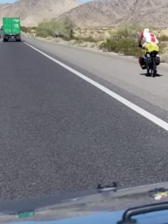
I've seen people fined for these in Colorado and California in the mountains in the winter.
Also, even worse, at the checkpoints (chain up areas) they have people waiting there with chains - And selling them on the spot for outrageous prices ranging from $85 to $300 USD. In the local Walmart these are like $25.
Posted: Jul 12, 2019, 6:47 PM
Chris Collura replied to Rebecca Holliday's comment.
Rebecca Holliday Not for me either. Donuts are far better than scrambled eggs!
Posted: Jul 12, 2019, 6:46 PM
Chris Collura replied to Edward Moran's comment.
Edward Moran Storm chasers who went there are filming 60 MPH+ winds and storm surge / waves under partly sunny skies :]
Posted: Jul 12, 2019, 6:42 PM
Chris Collura commented on iCyclone's photo.
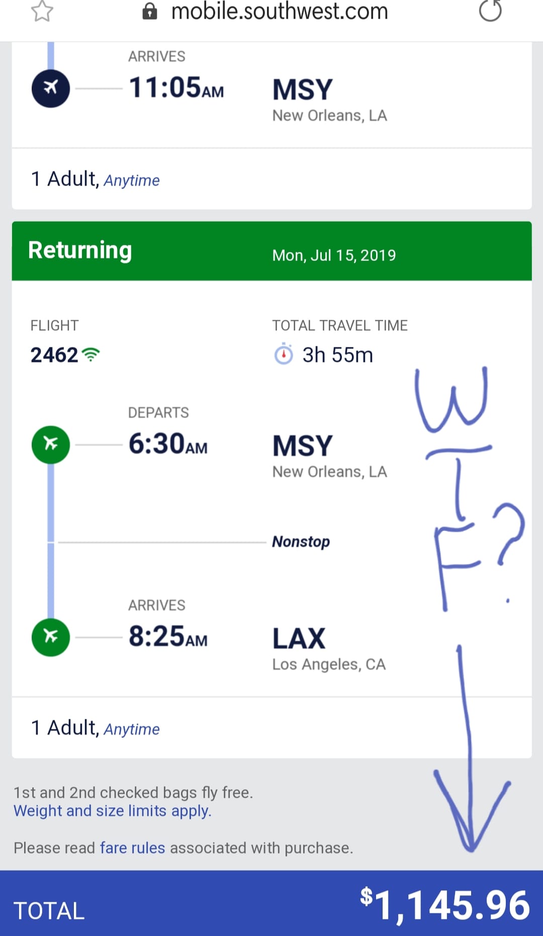
I was watching this one but I just dont see a reason NOR justifying airfares now of over $1000 to fly there from LA (if there was a typhoon in Asia - There isn't now but just saying and checked for fun - The flights THERE are shockingly LESS - Like $750)! July is a heavy travel month in the USA.
Yesterday I committed to not chasing it. I drove back from Chicago to Orange County here in S California. I COULD have drive south to intercept Barry then west to CA after, but even that wasnt worth it. To me at least.
Had the shear and dry air not been there, Barry would be a totally different cup of tea. Probably cat 3 and far more devastating (and better looking too)!
With that said, flooding and storm surge can be devastating even with weak storms because of the way the undersea shallows are in the gulf coast, as well as low lying areas.
A hurricane that produces a 10 foot surge on the eastern US coast such as NC or FL would produce a 25 foot surge in parts of the Gulf coast!
Posted: Jul 12, 2019, 6:09 PM
Chris Collura commented on Nick Nolte's photo.
Oh nice! The "Astrojet" vintage livery and polished aluminum "jet age" style! I saw this several years back in Chicago at O'Hare. I'm sure the service aboard and the way people dress aren't anything like when planes looked like this!
Posted: Jul 12, 2019, 6:07 PM
https://youtu.be/qaPUufAdJeE
Posted: Jul 12, 2019, 6:02 PM
Chris Collura commented on a post.
Posted: Jul 12, 2019, 1:24 PM
Chris Collura replied to his own comment.
Dave Lewison Yeah. I get those seats literally right AT the 24 hour check in. I'm always in the A group.
Posted: Jul 12, 2019, 1:23 PM
Chris Collura replied to a comment.
Posted: Jul 12, 2019, 1:18 PM
Chris Collura commented on a post.
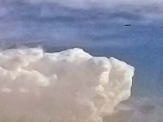
Posted: Jul 12, 2019, 1:05 PM
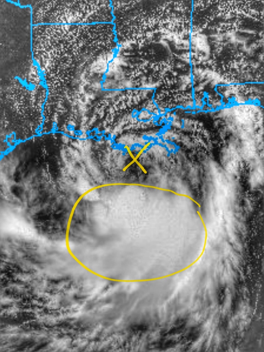
Looking at the visible satellite of strong tropical storm Barry nearing landfall (early Saturday) this Friday (7/12) afternoon. The storm lacks any deep convection near the so called "exposed" center as northerly wind shear and dry air pushes the thunderstorms (circled) hundreds of miles south if the center (the "X"). The low clouds mark the circulation of the storm, but this is pretty much the strongest it will get (at or just below a minimal hurricane) wind wise. Had the shear been absent, this would undoubtedly been a major hurricane and of course I would be there. But it's not, so I'm not either! ✂️✂️✂️
Posted: Jul 12, 2019, 12:59 PM
Chris Collura commented on Dave Lewison's photo.
I'm sure some airlines are flying right over that too like nothing since theres no tall thunderstorms to worry about.
Would be kinda cool to look down at the swirls of low clouds and whitecaps in the sea below as you use your SWA free drink coupons.
Posted: Jul 12, 2019, 9:27 AM
Chris Collura replied to a comment.
Posted: Jul 12, 2019, 9:25 AM
Chris Collura commented on Brad Hannon's video.
That was an incredible day!
Posted: Jul 12, 2019, 9:23 AM
Chris Collura commented on a post.
Posted: Jul 12, 2019, 9:22 AM
Chris Collura commented on Margie Kieper's post.
Sounds like a "typical" night in Miami-Dade to me.
Posted: Jul 12, 2019, 9:21 AM
Chris Collura commented on a live video.
Posted: Jul 12, 2019, 9:19 AM
Chris Collura replied to Jamie Simms's comment.
Posted: Jul 12, 2019, 9:18 AM
Chris Collura commented on Daniel Shaw's post.
Haha. I forgot all about that it's basically the dead of winter in the southern hemisphere.
Posted: Jul 12, 2019, 8:03 AM
Chris Collura commented on Travel Rugrats's video.
That's a hell of a story. I would love to see his book. Kinda sad they try to sue him. As a religious man I doubt he cannibalized anyone. But remember he was in a desperate situation.
Posted: Jul 12, 2019, 7:39 AM
Chris Collura replied to George Kourounis's comment.
George Kourounis Yeah in that case with all the transfers and extra connections you'll have to make.
Posted: Jul 12, 2019, 7:38 AM
Chris Collura replied to Mike Griffith's comment.
Mike Griffith Every weak storm since 2005 is called "Katrina" and hyped to the max.
Posted: Jul 11, 2019, 7:26 PM
Chris Collura commented on Healthy's video.
This in the wrong hands can be a dangerous weapon.
Posted: Jul 11, 2019, 7:15 PM
Chris Collura commented on Verne Carlson's video.
What software does this to animate pic like this?
Posted: Jul 11, 2019, 7:11 PM
Chris Collura replied to a comment.
Posted: Jul 11, 2019, 7:09 PM
Chris Collura replied to a comment.
Posted: Jul 11, 2019, 7:08 PM
Chris Collura commented on Doug Kiesling's photo.
Dont you wish it was that easy?
Posted: Jul 11, 2019, 6:59 PM
Chris Collura replied to George Kourounis's comment.
Doug Kiesling Posted them. Enjoy. Looks like chasing a super typhoon is "cheaper" when the time arises.
Posted: Jul 11, 2019, 6:58 PM
Chris Collura replied to George Kourounis's comment.

Posted: Jul 11, 2019, 6:58 PM
Chris Collura replied to George Kourounis's comment.
Posted: Jul 11, 2019, 6:58 PM
Chris Collura replied to George Kourounis's comment.
Told ya
Posted: Jul 11, 2019, 6:47 PM
Chris Collura replied to George Kourounis's comment.
George Kourounis The tickets to fly to Asia are actually LESS than flying to New Orleans (from S Cal). Seriously ... I looked just cuz it was so funny seeing flights twice as much as those 10 times the distance literally around the world! Go figure.
Posted: Jul 11, 2019, 6:46 PM
Chris Collura replied to George Kourounis's comment.
Doug Kiesling The tickets to fly to NOLA are insane as its July travel season anyway.
Posted: Jul 11, 2019, 6:45 PM
Chris Collura replied to Brian McNoldy's comment.
Brian McNoldy Probably people pissed in it too much.
Posted: Jul 11, 2019, 6:39 PM
Chris Collura replied to his own comment.
https://en.m.wikipedia.org/wiki/Rolling_shutter
Posted: Jul 11, 2019, 6:36 PM
Chris Collura replied to Forrest Loucks's comment.
Posted: Jul 11, 2019, 6:35 PM
Chris Collura commented on Max Olson's photo.
Yeah same here. I decided not to go after it.
Posted: Jul 11, 2019, 6:32 PM
Chris Collura replied to his own comment.
https://youtu.be/YGg0SxRYAvA
Posted: Jul 11, 2019, 6:31 PM
Chris Collura updated his status.
Safely back in Anaheim, California for work and such there after being out in the central USA from May 6 through July 9 and storm chasing on and off with some skydiving and part time work in Chicago.
I decided NOT to chase "whatever-it-well-be-cane" Barry in the Gulf coast. I dont like weak systems and its mainly a flooding event at most. Not justified dropping $850 on a round trip plane ticket there and all the other logistics. I'll save that for a REAL hurricane.
Posted: Jul 11, 2019, 6:18 PM
Chris Collura replied to Robert Westley's comment.
Jack Corso Maybe flooding as the colony pisses all over the place? Haha
Posted: Jul 11, 2019, 6:18 PM
Chris Collura commented on Ericka Gray's photo.
Rolling shutter and phone shaking.
Posted: Jul 11, 2019, 6:17 PM
Chris Collura commented on a post.
Posted: Jul 11, 2019, 5:19 PM
Chris Collura commented on Derek Sibley's post.
I wonder if you can see these visually?
Posted: Jul 11, 2019, 5:18 PM
Chris Collura replied to Colt Forney's comment.
Posted: Jul 11, 2019, 5:17 PM
Chris Collura commented on Tony Laubach's photo.
On a storm chasers car ofcourse. He saw the divots. Haha
Posted: Jul 11, 2019, 5:16 PM
Chris Collura commented on Cheryl Schumacher Chang's post.
Tropical storm "Barely" :]
Posted: Jul 11, 2019, 5:15 PM
Chris Collura replied to Robert Westley's comment.
Robert Westley Not worth it.
Posted: Jul 11, 2019, 10:23 AM
Chris Collura replied to Doug Kiesling's comment.
Doug Kiesling Its basically an MCS at this point. Like Gordon last year every Tom, Dick, and Harry went after.
Posted: Jul 11, 2019, 10:22 AM
Chris Collura commented on a post.
Posted: Jul 11, 2019, 6:38 AM
Chris Collura commented on David Gold's photo.
Clearly an extreme rain event. If this intensifies (right now it has northerly shear on it) it will barely be a hurricane hitting Louisiana on Saturday.
Posted: Jul 11, 2019, 6:03 AM
Chris Collura replied to Lisa Beal's comment.
Lisa Beal Two tour vans were rolled, Roger's and the one behind it.
Posted: Jul 11, 2019, 6:02 AM
Chris Collura replied to Kris Warren's comment.
Kris Warren This stuff was also rain wrapped.
Posted: Jul 11, 2019, 5:55 AM
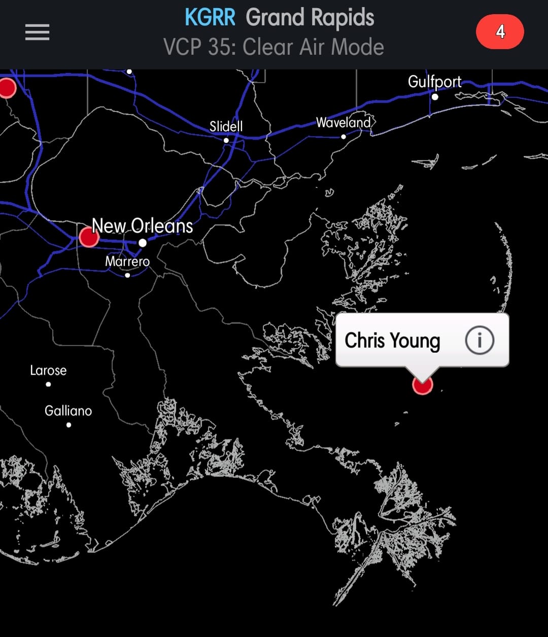
Wait, there's no bridge out to the Chandelur Islands off Louisiana! I guess it's nice for this storm spotter to have a boat and get some fishing in before soon to be Barry moved through!
Posted: Jul 10, 2019, 5:14 PM
Chris Collura commented on Brian Stertz's post.
Didnt something like this happen in Italy a few years ago? Crazy!
Posted: Jul 10, 2019, 5:12 PM
Chris Collura commented on Dave Lewison's photo.
The other ones such as the GFS look muck more realistic IMO.
Posted: Jul 10, 2019, 5:11 PM
Chris Collura commented on Skip Talbot's post.
Scary stuff. I was waiting for them to post this. Very lucky no one killed.
Posted: Jul 10, 2019, 5:07 PM
Chris Collura commented on a post.
Posted: Jul 10, 2019, 3:21 PM
Chris Collura commented on Bill Hark's post.
Thank God this is relatively harmless. I keep thinking of the scifi / horror movie "Life" if you know what I mean :/
Posted: Jul 10, 2019, 3:18 PM
Chris Collura replied to William T. Reid's comment.
William T. Reid Yeah. Haha
Posted: Jul 10, 2019, 1:23 PM
Chris Collura commented on David Gold's photo.
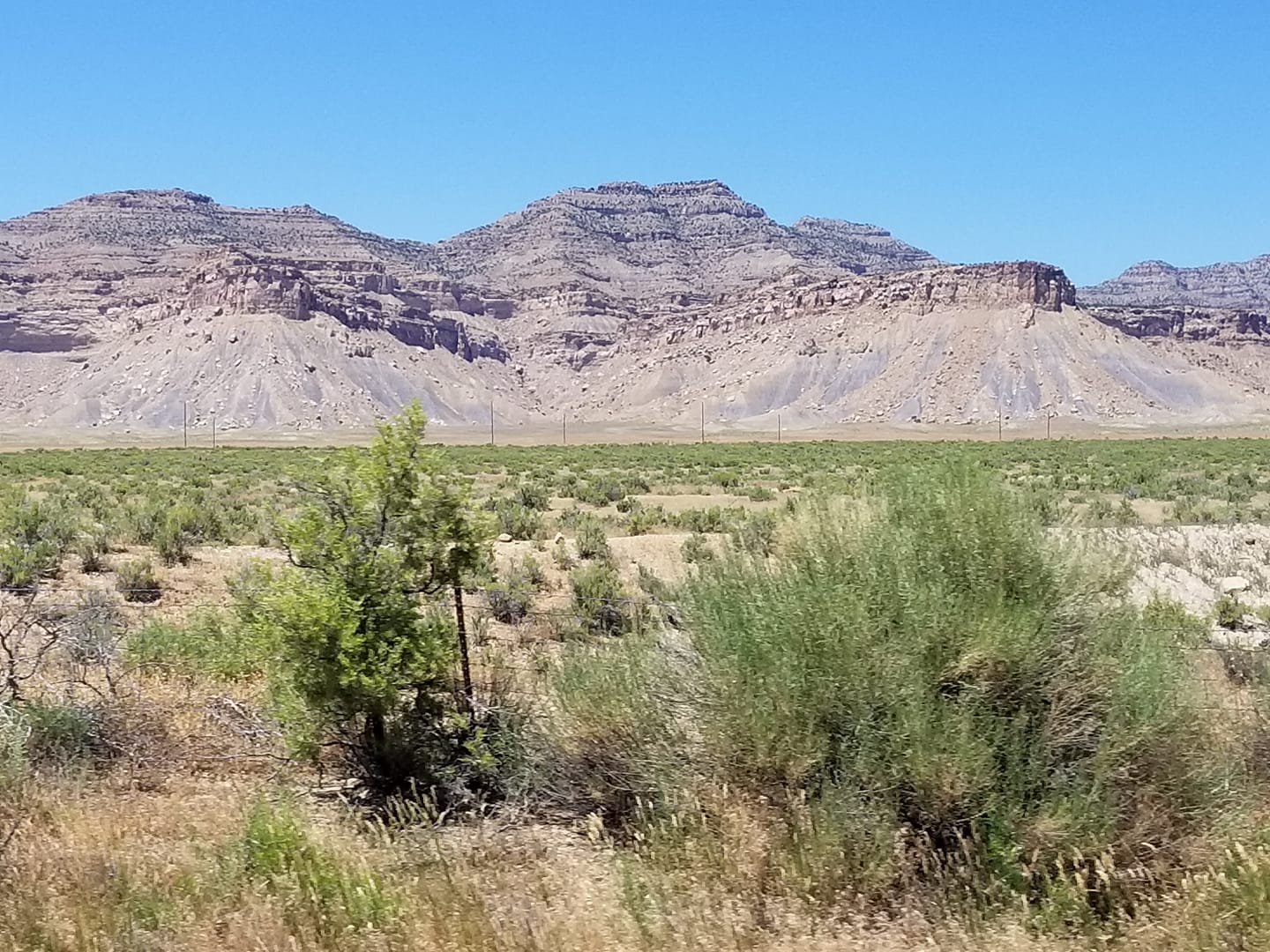
Posted: Jul 10, 2019, 1:21 PM
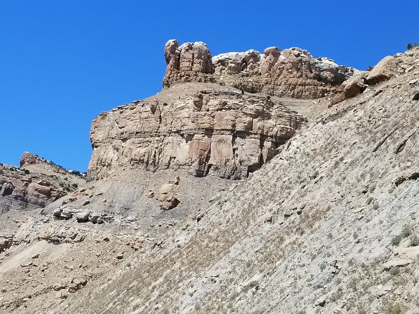
Currently in the Moab desert area crossing Utah en route for southern California. But I'm thinking hurricanes (what? Not out here!) ... Maybe fly to gulf coast out of Las Vegas or LA for Barry this weekend. Well see ... In the meantime enjoy the view!
Posted: Jul 10, 2019, 5:36 AM
Chris Collura commented on Maureen Loffredo's post.
I've seen this. My mom worked at an Alzheimers day care centre (for people with dementia and Alzheimers) in Florida years ago. It's very sad and this is basically Hell on earth for these people.
Posted: Jul 10, 2019, 12:37 AM
Chris Collura is feeling confused.
Ok not to hype anything up but I'm in the process of driving from Chicago back to California after 2 months on and off of severe weather chasing in the central USA.
Now, low and behold, a unique tropical system continues to show organization in the northern Gulf of Mexico with some models showing a hurricane heading west into Texas towards the weekend!
Should I continue out to California and drop $$$ to fly out into Houston or something? Or just turn around and drive to Texas and go to California after that? Not go at all? Humm. I'm confused.
Posted: Jul 9, 2019, 9:08 PM
Chris Collura commented on George Kourounis's post.
I'm sure George Kourounis knows such logistics. Flight, ship, then landing team. Hike up, and rappel down into the crater. Plus lots of $$$ and lugging all your gear across the globe. Piece of cake, Daniel Shaw.
Posted: Jul 9, 2019, 9:08 PM
Chris Collura replied to Daniel Shaw's comment.
Daniel Shaw Oh he can. Trust me.
Posted: Jul 9, 2019, 12:50 PM
Chris Collura commented on Far & Wide's post.
Wall Drug, SD anyone?
Posted: Jul 9, 2019, 12:46 PM
Chris Collura replied to Bob Gaudio's comment.
Posted: Jul 8, 2019, 10:08 PM
Chris Collura commented on Vinh X Nguyen's photo.
Asians don't get lost. Lol
Posted: Jul 8, 2019, 9:02 PM
Chris Collura replied to Nate Willard's comment.
Tim Marshall Aw come on, Tim. Why not?
Posted: Jul 8, 2019, 9:00 PM
Chris Collura replied to his own comment.
https://youtu.be/msWi0c4tHV8
Posted: Jul 8, 2019, 9:00 PM
Chris Collura commented on Cheryl Schumacher Chang's post.
Huh? Lol!!!!!!
Posted: Jul 8, 2019, 5:06 PM
Chris Collura commented on a post.
Posted: Jul 8, 2019, 5:05 PM
Chris Collura commented on David Gold's post.
Exactly. People are asking me constantly about it and I just answer "it hasn't even formed yet" :)
Posted: Jul 8, 2019, 7:52 AM
Chris Collura replied to Daniel Shaw's comment.
Daniel Shaw In this case a phone call is the best way to resolve this.
Posted: Jul 8, 2019, 7:51 AM
Chris Collura commented on Tim Marshall's photo.
Looks like a "Yurt".
Posted: Jul 8, 2019, 7:44 AM
Chris Collura commented on George Kourounis's photo.
Wow nice ... It would be so interesting to talk to that guy!
Posted: Jul 8, 2019, 4:37 AM
Chris Collura replied to Greg Waltrip's comment.
Mary E. Gibson That's right. The positive lightning under a thunderstorm is loosely related to supercells with developing mesocyclones / tornado genesis due to the forward flank downdraft bringing the positive charged cloud layers closer to the ground.
Posted: Jul 8, 2019, 4:32 AM
Chris Collura commented on iCyclone's photo.
I've been watching these models too ... Definitely wont be another Michael. But looks to be a minimal tropical / subtropical storm with lots of rain at best.
Posted: Jul 7, 2019, 4:50 PM
Chris Collura replied to Greg Waltrip's comment.
Posted: Jul 7, 2019, 4:43 PM
Chris Collura commented on Chris Tomer's photo.
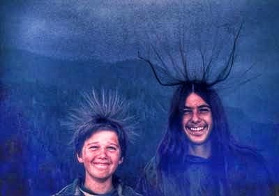
Posted: Jul 7, 2019, 4:39 PM
Chris Collura replied to Lori Ferguson's comment.
Lori Ferguson Yeah not stacked either and this private company draws quite a crowd too with local rock band, beer, ribs, and skydives!
Posted: Jul 7, 2019, 4:37 PM
Chris Collura commented on Vanessa Vinent WPBF's photo.
Looks like a MAJOR rain event with low end tropical storm forced winds ... "South Central Rain" :)
Posted: Jul 7, 2019, 4:32 PM
Chris Collura commented on Severe Storm Interceptors's photo.
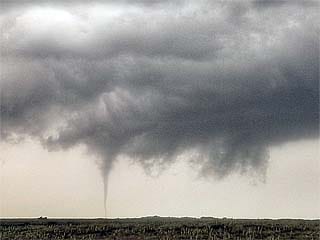
Posted: Jul 7, 2019, 4:29 PM
Chris Collura commented on Doug Kiesling's post.
Its Wal-Mart. What would you expect?
Posted: Jul 7, 2019, 3:36 PM

Here's my shot of some cool fireworks (at the skydiving "Independence Boogie" in Rochelle, IL) on July 6, 2019.
Posted: Jul 7, 2019, 3:34 PM
Chris Collura replied to his own comment.
Jack Corso EXACTLY
Posted: Jul 7, 2019, 3:33 PM
Chris Collura added a new photo.
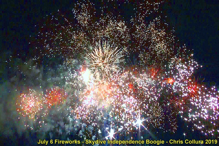
Fireworks at the Chicagoland Skydiving Center "Independence Boogie" in Rochelle, IL on July 6, 2019.
Posted: Jul 7, 2019, 3:17 PM
Chris Collura commented on Tim Marshall's post.
I got to start traveling more (and give up skydiving possibly) ... Much safer and certainly more acceptable!
Posted: Jul 7, 2019, 3:15 PM
Chris Collura commented on Chris Tomer's photo.
Being a storm chaser lightning is still my biggest fear. Youll never see (nor even hear) the bolt that kills you.
Posted: Jul 7, 2019, 1:57 PM
Chris Collura commented on Doug Kiesling's photo.
Brown ocean ... Euro has this forming into a hurricane in a few days. Not sure if I should waste money on it just yet.
Posted: Jul 7, 2019, 10:44 AM
Chris Collura commented on a post.
Posted: Jul 7, 2019, 10:06 AM
Chris Collura commented on Jack Corso's post.
Their pissed off on the gas tax increase raping them back...
Posted: Jul 7, 2019, 10:05 AM
Chris Collura commented on David McSweeney's post.
Plus all toll roads being raised just 10% with the money raked in on that could have been an alternative.
Posted: Jul 7, 2019, 10:03 AM
Chris Collura commented on Stormtrack's post.
Never seen it "originate" over the central USA. That's very strange.
Posted: Jul 7, 2019, 8:16 AM
Chris Collura added a new photo.
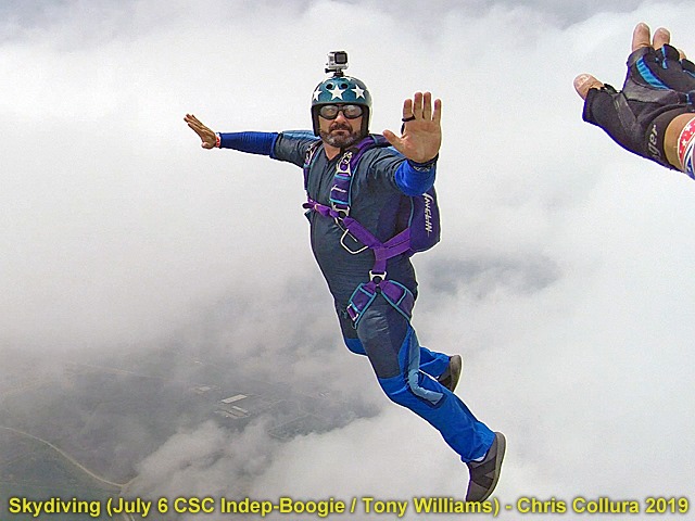
Helicopter jumps (out of R44) at the Independance Boogie in Rochelle, IL on July 6. Thanks to Tony Williams for some of the photos as well!
Posted: Jul 7, 2019, 8:16 AM
Chris Collura added a new photo.

Helicopter jumps (out of R44) at the Independance Boogie in Rochelle, IL on July 6. Thanks to Tony Williams for some of the photos as well!
Posted: Jul 7, 2019, 8:16 AM
Chris Collura added a new photo.

Helicopter jumps (out of R44) at the Independance Boogie in Rochelle, IL on July 6.
Posted: Jul 7, 2019, 8:16 AM
Chris Collura added a new photo.
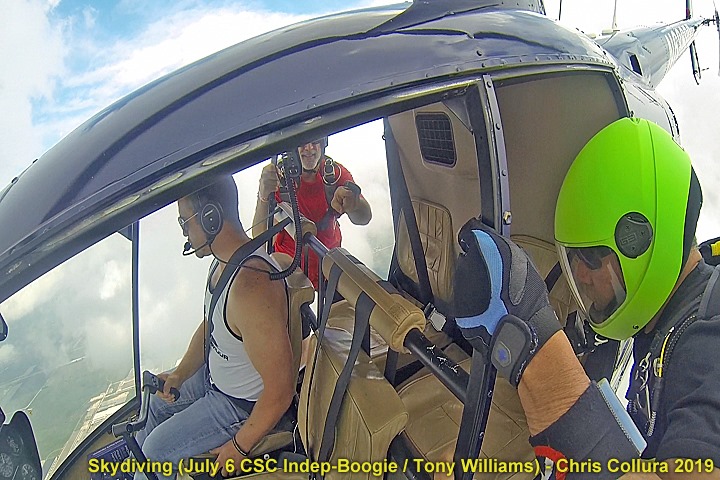
Helicopter jumps (out of R44) at the Independance Boogie in Rochelle, IL on July 6.
Posted: Jul 7, 2019, 8:16 AM
Chris Collura added a new photo.

Helicopter jumps (out of R44) at the Independance Boogie in Rochelle, IL on July 6. Thanks to Tony Williams for some of the photos as well!
Posted: Jul 7, 2019, 8:16 AM
Chris Collura added a new photo.
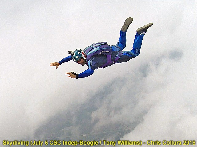
Helicopter jumps (out of R44) at the Independance Boogie in Rochelle, IL on July 6. Thanks to Tony Williams for some of the photos as well!
Posted: Jul 7, 2019, 7:55 AM
Chris Collura added a new photo.
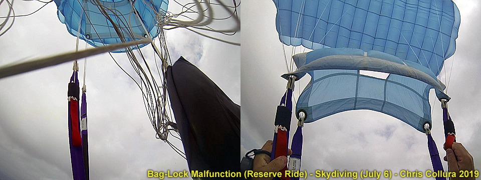
July 6, 2019 over Rochelle, Illinois during the CSC Independance Boogie and exiting a R44 helicopter with two other jumpers. Exit was around 4,000 feet AGL with a planned opening at 2,500 or so. Baglock malfunction. View to the left is the reserve opening and deployment bag for my main as I'm grabbing it to the right. Yeah in hind sight I should have cut away (debatable when there's nothing out as this is a high speed malfunction at 2,500 feet AGL and there's little time). I went straight for the D ring and just threw it to China, and was awarded with this beautiful blue reserve over my head to the right, while stowing my main (which never came out) in it's D bag between my legs.
Posted: Jul 7, 2019, 7:51 AM
Chris Collura commented on his own post.

Posted: Jul 7, 2019, 6:20 AM
Chris Collura commented on Brandon Clement's post.
I'll be passing near there in a few days.
Posted: Jul 6, 2019, 9:52 PM
Chris Collura is feeling grateful.
While attending the CSC Independence skydiving Boogie in Rochelle, IL I experienced my first main total malfunction (on my second helicopter jump and jump 761 for me). The reserve ride was so awesome given I got a second chance at life! Always be alert that parachute equipment / packing is never perfect and be prepared to handle such emergencies. Some crazy pics forthcoming.
Posted: Jul 6, 2019, 7:22 AM
Chris Collura replied to Kyle Bower's comment.
Posted: Jul 6, 2019, 7:18 AM
Chris Collura commented on David McSweeney's post.
You may have voted NO but it's still in effect. Even worse are the gas stations that are in rural areas of Illinois (such as Rochelle) that raised their prices 30 or 40 cents (not the 20 as expected). That's what angers me the most.
Posted: Jul 6, 2019, 6:46 AM
Chris Collura commented on William T. Reid's post.
Great end of the season for you too. Day 3 of the Cheyenne Ridge looks like tornadoes again in SE WY (today July 6).
Posted: Jul 5, 2019, 10:13 PM
Chris Collura replied to Kyle Bower's comment.
Posted: Jul 5, 2019, 10:04 PM
Chris Collura replied to his own comment.
Lori Ferguson Now I'm sitting here in Chicago and not be there in several days. What a f'cking HOPE LESS feeling.
Posted: Jul 5, 2019, 9:53 PM
Chris Collura commented on Billy Wade's post.
I'm headed back to S California later this week. I heard in the Orange County area it didnt affect that area much.
Posted: Jul 5, 2019, 9:46 PM
Chris Collura commented on a post.
Posted: Jul 5, 2019, 9:42 PM
Chris Collura commented on Brandon Sullivan's photo.
You CANNOT "chase" earthquakes.
Posted: Jul 5, 2019, 8:02 PM
Chris Collura commented on Brian Stertz's post.
For those interested...please play! 😎
* How old are you: 49
* Surgeries: 1
* Tattoos: 0
* Ever hit a deer: no
* Rode in an ambulance: yes
* Ice skated: yes
* Rode a motorcycle: yes
* Stayed in hospital: yes
* Last phone call: Dad
* Last text from: Best Friend
* Watched someone actually die: Yes (gasoline truck fire)
* Pepsi or Coke: Coke
* Favorite Pie: Chocolate Cream
* Favorite season: spring
* Broken Bones: No
* Received a Ticket: Yes
* Favorite color: Blue
* Sunrise or sunset: Sunset
* Ocean or mountain: mountains
* Who will play along: anyone
Hold your finger down and copy.
Posted: Jul 5, 2019, 5:42 PM
Chris Collura commented on Jonas Piontek Photography's photo.
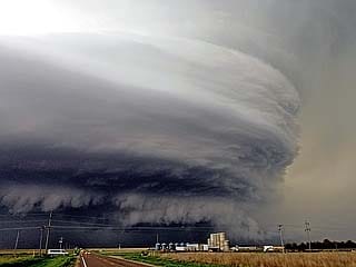
Posted: Jul 5, 2019, 5:36 PM
Chris Collura commented on Gulf Coast Storm Center, LLC's post.
Ahhh the so called "phantom hurricane". Derek Sibley can tell you all about those :)
Posted: Jul 5, 2019, 5:35 PM
Chris Collura commented on Newegg's post.
I wanna see how long it takes to encode a 4k video movie! Bet it screams!
Posted: Jul 5, 2019, 5:32 PM
Chris Collura commented on his own photo.

Posted: Jul 5, 2019, 5:32 PM
Chris Collura replied to Jason Foster's comment.

Posted: Jul 5, 2019, 5:15 PM
Chris Collura commented on his own photo.
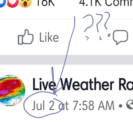
Posted: Jul 5, 2019, 5:10 PM

Dear Facebook ... You know I'm a storm chaser and refreshing the display only gives me content from like 2 days (or more) ago and hides the most recent trends / news.Plus I see something right on my page, exit to check something and go back into FB and its gone (and cannot find it anywhere = WTF?)!!! Your "algorithm" sucks to Hell (and can 'shove it'). Sorry but it does.Today is JULY 5 not the 3rd, FB...
Posted: Jul 5, 2019, 5:06 PM
Chris Collura commented on Jessica Caputo's photo.
Must be riddled with STDs for under $10...
Posted: Jul 5, 2019, 5:02 PM
Chris Collura commented on Verne Carlson's photo.
Good ... And I'm happy to see you still chase :)
Posted: Jul 5, 2019, 4:43 PM
Chris Collura replied to William T. Reid's comment.
Jack Corso This sucks (for MOST of us).
Posted: Jul 5, 2019, 4:39 PM
Chris Collura commented on Brian Stertz's post.
It's doing it all NOW like a summer cold / flu since 95% of the chasers gone.
Posted: Jul 5, 2019, 4:38 PM
Chris Collura replied to William T. Reid's comment.
Jack Corso Get your crying towels out.
And I'll give my empty bank account AND insurance company the middle finger too if I see another photogenic tornado.
Posted: Jul 5, 2019, 3:46 PM
Chris Collura commented on Live Weather Radar Page's photo.
That map is from.2 days ago. Why am I just seeing it now?
Posted: Jul 5, 2019, 3:44 PM
Chris Collura replied to William T. Reid's comment.
William T. Reid Both today and even tomorrow should be great days almost in the same area.
Posted: Jul 5, 2019, 3:28 PM
Chris Collura replied to his own comment.
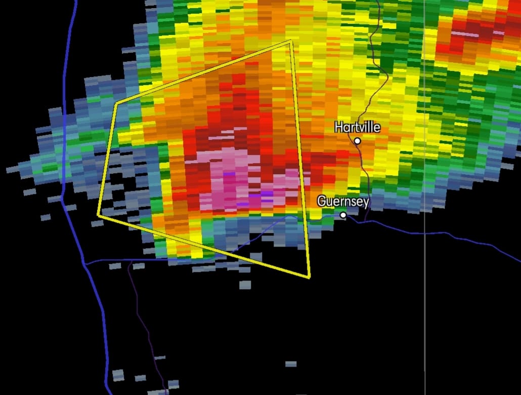
Posted: Jul 5, 2019, 3:20 PM
Chris Collura commented on David Gold's photo.

Posted: Jul 5, 2019, 3:20 PM
Chris Collura commented on a post.
Posted: Jul 5, 2019, 2:29 PM
Chris Collura commented on David Gold's photo.
And my bald spot will certainly get bigger...
Posted: Jul 5, 2019, 10:24 AM
Chris Collura replied to David Gold's comment.
David Gold Yeah I know. So.did I see dozens of better looking setups that were up-slop instead. The more chasers on it the less it will pan out. Yeah I gave up couple weeks ago too.
Posted: Jul 5, 2019, 8:12 AM
Chris Collura commented on Jack Corso's photo.
Colin? Should be COLON. LOL
Posted: Jul 5, 2019, 8:12 AM
Chris Collura replied to Maggie Barnett's comment.
Jack Corso Waste of money on some logo...
Posted: Jul 5, 2019, 8:10 AM
Chris Collura replied to Jack Corso's comment.
Jack Corso Plus wasted my time and money on this tease.
Posted: Jul 5, 2019, 8:08 AM
Chris Collura commented on Sea-Doo's post.
Dont buy these ... IF you do, dont bother with any so called "extended warranty". These will break (usually major and costly engine damage at least $5 grand, even $10,000 to fix) and the warranty will DENY the repair leaving you with the bill. I left the sport thanks to this and a battle for over a year with the BBB and warranty company over it.
Posted: Jul 5, 2019, 8:02 AM
Chris Collura commented on his own post.
And even worse this may happen AGAIN today (July 5) if the HRRR verifies.
Posted: Jul 5, 2019, 8:00 AM
Chris Collura commented on Scott Bennett's post.
They pushed and shoved the WRONG PERSON. We all know who SHOULD HAVE been beat up now, don't we?
Posted: Jul 5, 2019, 7:58 AM
Chris Collura commented on Boredom Therapy's post.
I've done the "double" (or even "triple" feature) experience by getting into a theater on one ticket, and looked at other movies starting when my original one ended with a movie buddy on mine. It is stealing in a sense though so I stopped doing it. No, they DO NOT check tickets at the "other" cinema entrances!
Posted: Jul 5, 2019, 7:53 AM
Chris Collura commented on Bobby Deskins's post.
Just put some duct tape across it.
Posted: Jul 5, 2019, 7:52 AM
Chris Collura commented on Roger Edwards's post.
After being out since May 7 on and off through late June ... I saw the awesome stuff William T. Reid posted and just kinda felt like someone put their foot deep into my crotch.
I am far far away in Chicago area, pretty much gave up on chasing MCSs and moderate risks with "2% tor probs" with over $2000 in damages to my vehicle (pitted mirrors, cracked windshield, blown out back window, and shattered smartphone screen - From 100+ MPH gravel on June 21) that my insurance WONT cover (just paid $500 for the rear window) - I gave up.
In a few days, with the vehicle driveable, I'll slowly mosy my was back to S California for IT work to cover the expenses basically wasted the past few weeks.
Posted: Jul 5, 2019, 6:36 AM
Chris Collura commented on Billy Wade's post.
As long as Colt Forney and Chris Collura aren't there IT WILL happen.
Posted: Jul 4, 2019, 5:50 PM
Happy 4th of July to all ... Independence Day 2019 :)
Posted: Jul 4, 2019, 5:35 PM
Chris Collura commented on Maureen Loffredo's post.
Entrapment at its finest.
Posted: Jul 4, 2019, 5:34 PM
Chris Collura commented on David McSweeney's post.
And many gas stations raised their prices 30 or even 40 cents (the increase was 19 cents) ... Classy.
Posted: Jul 4, 2019, 5:17 PM
Chris Collura commented on Stormtrack's post.
So late in the season... Couldnt get THIS in June?
Posted: Jul 4, 2019, 5:04 PM
Chris Collura commented on Miranda Kay Roberts's post.
Close ... Technically it was from near the end of the "cold war" :)
Posted: Jul 4, 2019, 2:06 PM
Chris Collura commented on Tony Laubach's post.

Posted: Jul 4, 2019, 6:25 AM
Chris Collura replied to Aaron Pippin's comment.
Aaron Pippin Its Facebook f'cking up again.
Posted: Jul 4, 2019, 6:24 AM
Chris Collura replied to Brett Castro's comment.
Posted: Jul 3, 2019, 9:14 PM
Chris Collura commented on Van Perpetual Bloom's post.
1. What was the last thing you put in your mouth? BBQ pork chops.
2. Do you sleep naked? Yes!
3. Worst physical pain you ever been in? Knee bursitis.
4. Favorite place you have been? Tornado Alley USA.
5. How late did you stay up last night? 1:30 AM.
6. If you could move somewhere else, where would you go? California.
7. Which of your Facebook friends lives closest to you? Van Perpetual Bloom.
8. When was the last time you cried? Yesterday after seeing fellow storm chaser Dale Sharpe memorial.
9. What matters most to you? My health and social acceptance.
10. Two of your favorite movies: "Twister" and "Guardians of the galaxy".
11. What's your favorite season? Spring.
13. If you could talk to ANYONE right now, who would it be? My mom (deceased).
14. Are you a good influence? No.
15. Does pineapple belong on pizza? Why not? NO way - It's a frruit, and Italian food doesn't use fruit :)
16. You have the remote, what show would you watch? Stranger Things.
17. Five people who you think will play? Not sure.
18. First Concert Attended: Rush.
19. Favorite food? King crab legs.
20. When you were a kid, what did you want to be when you grew up: Scientist.
Posted: Jul 3, 2019, 9:05 PM
Chris Collura commented on Thad Bowling's photo.
Car henge!
Posted: Jul 3, 2019, 8:54 PM
Chris Collura commented on Sea-Doo's post.
Make sure Seadoo endorses extended warranties. You'll NEED them.
Posted: Jul 3, 2019, 8:50 PM
Chris Collura commented on a post.
Posted: Jul 3, 2019, 5:54 PM
Chris Collura commented on Jack Corso's post.
This is one topic I'll be the farthest away from on FB during these debates!!!!!!!
Posted: Jul 3, 2019, 5:51 PM
Chris Collura commented on Miranda Kay Roberts's post.
Basically sheet lightning.
Posted: Jul 3, 2019, 5:49 PM
Chris Collura commented on Chicagoland Skydiving Center's post.
Fireworks are July 6, not the 4th.
Posted: Jul 3, 2019, 5:13 PM
Chris Collura commented on Van Perpetual Bloom's post.
What a douche. Sad we still have monsters out there. Many gay people contrary to "stereotypes" can kick the living crap out of any straight / confused man anytime. Lol
Posted: Jul 3, 2019, 5:11 PM
Chris Collura commented on Dagmar Kress's photo.
Oh that "...Juliet Kilo" I remember as far back as Fort Lauderdale executive!
Posted: Jul 3, 2019, 5:11 PM
Chris Collura commented on a post.
Posted: Jul 3, 2019, 5:08 PM
Chris Collura replied to his own comment.
Jason Foster Welcome to "my world" :)
Social media and the internet put Cesium Chloride into that wound.
Posted: Jul 3, 2019, 3:17 PM
Chris Collura replied to Cristal Singleton Bass's comment.
Jesse V. Bass III That's right. Not only are people ignoring it but with the algorithm how many are gonna see it anyways?
Posted: Jul 3, 2019, 3:16 PM
Chris Collura commented on Billy Wade's post.
This is very sad but I can understand it given the extreme stress these folks are under between law enforcement and emergency responders.
Imagine trying to save ones life and you cannot get to them in time and they die in front of you? That's aweful survivor guilt and the feeling of "failure" for instance.
I remember my father working years back with the NYPD and many of his comrades took their lives. Plus alcoholism is rampant as well. Very sad for people trying to help others.
Posted: Jul 3, 2019, 3:11 PM
Chris Collura commented on Miranda Kay Roberts's post.
"Hang on Snoopy..."
Posted: Jul 3, 2019, 3:10 PM
Chris Collura replied to Cristal Singleton Bass's comment.
Jesse V. Bass III Not good.
Posted: Jul 3, 2019, 3:09 PM
Chris Collura commented on Miranda Kay Roberts's photo.
I remember the jingle "16 ounces and just one calorie" and asking my mom "wheres the calorie in the can?" And she says, "pour it out and look for it, the calorie is in there somewhere..." :)
Posted: Jul 3, 2019, 3:07 PM
Chris Collura replied to Cristal Singleton Bass's comment.
Doug Kiesling This is a brand new problem. Upload a pic and the comments go up but the "wheel turns and turns" (like my internet in Puerto Rico after hurricane Maria destroyed everything) lol.
I see the spinning wheel above too ^^^^ and on many other pics. Looks like FB updated and busted something.
Posted: Jul 3, 2019, 3:07 PM
Chris Collura replied to Cristal Singleton Bass's comment.
Cristal Singleton Bass FB is a total P.O.S now since they broke it.
Posted: Jul 3, 2019, 3:03 PM
Chris Collura commented on Scott Currens's post.
No it ain't... Just tried posting some pics and the comment goes but "wheel just spins and spins" and no pic goes up. Just blank. P.O.S.
Spins and spins (like my internet connection in Puerto Rico after Maria lol)...
Posted: Jul 3, 2019, 3:01 PM
Chris Collura commented on Scott Peake Weather's photo.
Posted: Jul 3, 2019, 2:56 PM
Chris Collura commented on Scott Bennett's photo.
"No photo description available" ... Check your internet connection and try again.
Posted: Jul 3, 2019, 2:52 PM
Chris Collura replied to his own comment.
Jason Foster I wonder if that's just depression (when I was down last year I actually felt physically I'll too, despite going to doctor and nothing wrong with me).
Posted: Jul 3, 2019, 10:38 AM
Chris Collura replied to James G. Lea's comment.
Doug Kiesling Actually 0.0391416
Posted: Jul 3, 2019, 10:01 AM
Chris Collura replied to his own comment.
Doug Kiesling OK so then it's a good thing. Esp since most hurricanes and tropical systems will be in Asian Pacific / Hawaii anyway this year as per climatology.
Posted: Jul 3, 2019, 9:50 AM
Chris Collura commented on a post.
Posted: Jul 3, 2019, 9:49 AM
Chris Collura commented on Doug Kiesling's post.
Great :/
Posted: Jul 3, 2019, 4:49 AM
Chris Collura commented on Tony Laubach's photo.
I've seen so many white cars lately. Even my dad bought a new car and it's super white!
Posted: Jul 3, 2019, 4:48 AM
Chris Collura commented on a post.
Posted: Jul 3, 2019, 4:47 AM
Chris Collura commented on Jason Foster's post.
Life ain't easy some times. Tell me about it. Be grateful you got your health.
Posted: Jul 3, 2019, 4:44 AM
Chris Collura commented on Dave Lewison's photo.
Brown
Posted: Jul 2, 2019, 5:39 PM
Chris Collura commented on ChaserCon's post.
I think Rodger Hill mentioned it will continue with his announcements at ChaserCon 2019.
Posted: Jul 2, 2019, 3:19 PM
Chris Collura commented on Doug Kiesling's photo.
Yeah just take one good picture and post it afterwards. Use your EYES for a change. Take it all in.
Posted: Jul 2, 2019, 3:17 PM
Chris Collura commented on Dave Lewison's photo.
It is butter, isnt it?
Hahaha!
Posted: Jul 2, 2019, 3:16 PM
Chris Collura replied to Jason Foster's comment.
Jason Foster Not just that is that I dont have it up and running much anymore as it's just cluttering stuff.
I turn it in only when reporting REAL severe weather and turn it off when I'm done. Just a few extra mouse clicks as long as GPS gate is running.
Posted: Jul 2, 2019, 1:50 PM

Guys this is NOT severe weather!Please start using Spotter Network for reporting severe weather and not things like traffic or hot weather!
Posted: Jul 1, 2019, 6:20 PM
Chris Collura commented on Billy Wade's post.
God bless these brave great people!
Posted: Jul 1, 2019, 6:18 PM
Chris Collura replied to Keith LaBotz's comment.
Keith LaBotz People in Oklahoma City in particular have turned out to be absolute low lifes (most of them).
They even walk right by you in the morning and dont even say hi or acknowledge you - VERY unusual for the country's mid section.
Posted: Jul 1, 2019, 5:47 PM
Chris Collura commented on Peggy Hamner Willenberg's photo.
Timelapse it ;)
Posted: Jul 1, 2019, 5:44 PM
Chris Collura commented on George Kourounis's post.
Another exciting adventure.
Posted: Jul 1, 2019, 5:43 PM
Chris Collura commented on Stormtrack's post.
Oh no. And the software he works in is the same system I develop in. Jesus.
Posted: Jul 1, 2019, 3:25 PM
Chris Collura replied to Jean Smith's comment.
Oh. Like the one in the movie "Dennis the Menace" :)
Posted: Jul 1, 2019, 3:17 PM
Chris Collura commented on Skip Talbot's photo.
Seeing this, Skip Talbot killed me. Many of us were way out of position on that day (5/28).
Posted: Jul 1, 2019, 3:12 PM
Chris Collura commented on Greg Ansel's post.
https://www.chillnicecream.com/
Posted: Jul 1, 2019, 12:05 PM
Chris Collura commented on David McSweeney's post.
Barbaric commodity taxing. Gas is already high enough. Enough with this BS already!
Posted: Jul 1, 2019, 11:08 AM
Chris Collura replied to his own comment.
Jason Persoff Thank you! Awesome seeing you all out there this year!
Generated by Sky-Chaser Chris Collura on Wednesday, March 24, 2021 at 6:19 PM UTC-07:00
HTML File "indx1907.htm" (Facebook) - Developed By Chris Collura
To Return To The HOME Page Of This Site Click The "INDEX.HTM" Link Here!