
Facebook Timeline Posts For August 2012
(Posts And Comments During August 2012 For Sky-Chaser Chris Collura On Facebook)
[ 2012-SEP ] [ BACK TO INDEX ] [ 2012-JUL ]
Posts And Comments For August 2012
Posted: Aug 30, 2012, 10:57 AM
Chris Collura updated his status.
Chase of Hurricane Isaac is completed. Two chases of this storm were done, one in Key West on Aug 26 as a strong tropical storm with 60 MPH winds, and the final intercept in Louisiana / Mississippi on Aug 29-30 as a category one hurricane with 80-85 MPH winds.
Mileage logged was about 424 miles for Aug 26 in the FL Keys and 2054 miles round-trip for the Aug 29-30 interception.
Thanks to all who supported my live video stream during this exciting event!
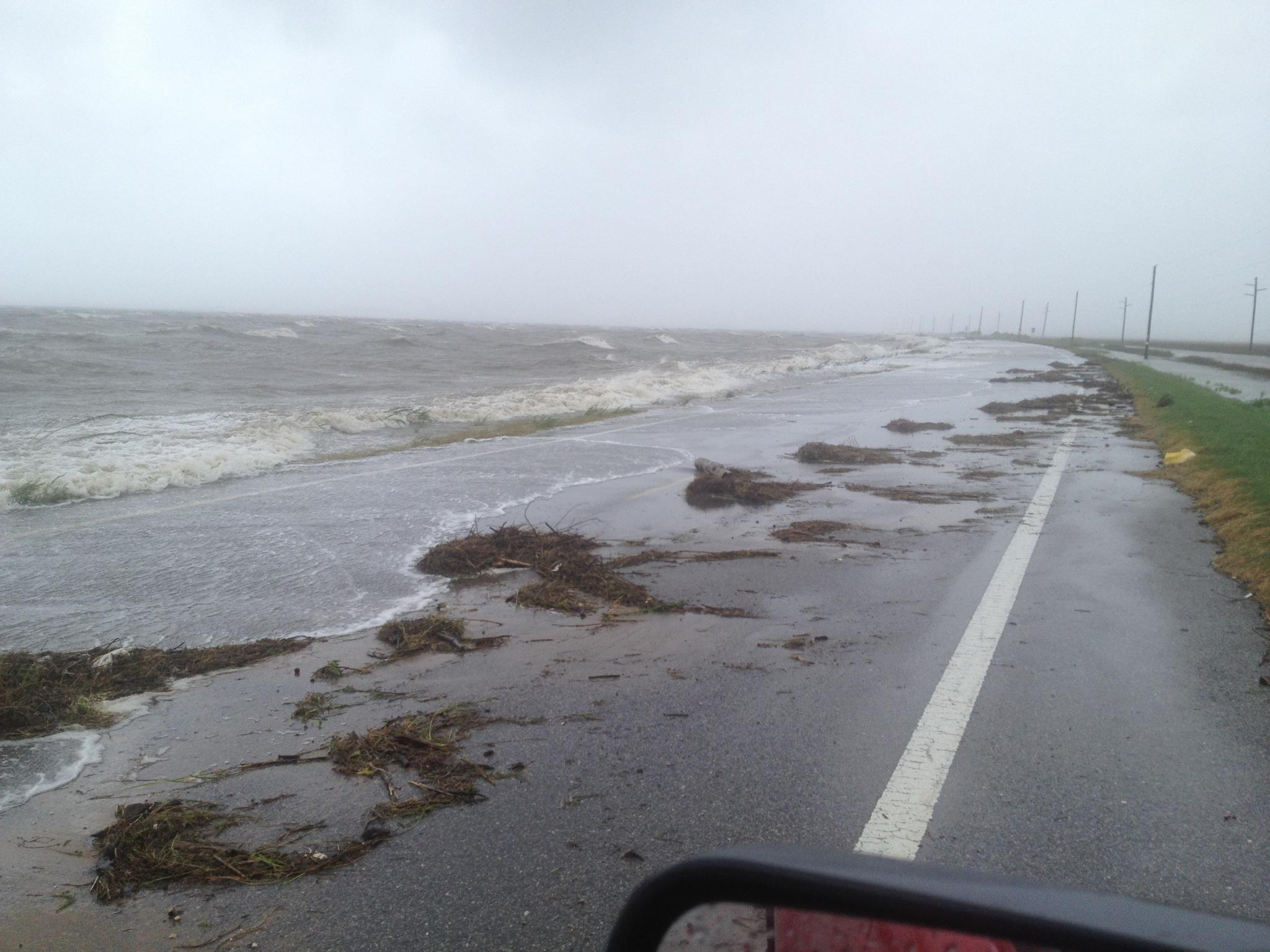
Posted: Aug 30, 2012, 10:53 AM
Chris Collura added a new photo.
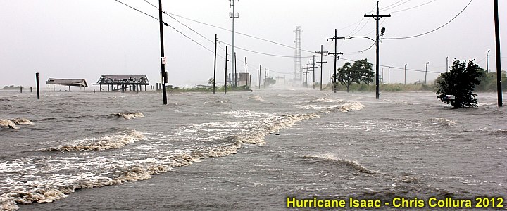
Storm surge on the morning of August 29, 2012 off I-10 southeast of New Orleans, Louisiana with winds gusting over 80 MPH. This was about 50 miles or so east of the eye of Hurricane Isaac.
Posted: Aug 29, 2012, 3:23 AM
Chris Collura updated his status.
Just entered near calm eye of Issac ... Not completly dead calm, but its about 80 deg F with warm foggy drizzle now south of Chauvin, LA. Waiting for sunrise.
Posted: Aug 29, 2012, 3:21 AM
Chris Collura added a new photo.
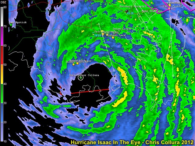
South of Chauvin, LA ... In the eye (warm, foggy, waiting for sunrise). Hurricane Isaac, Aug 29, 2012.
Posted: Aug 29, 2012, 1:54 AM
Chris Collura updated his status.
Almost in Isaac's eye near Houma / Terrabone Louisiana. Maybe a sunrise in the eye? Getting good wind blasting (80 MPH) in violent rain!
Posted: Aug 28, 2012, 3:21 PM
Chris Collura added a new photo.
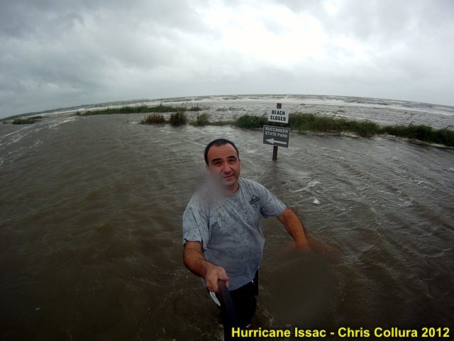
Lakeshore, MS at around 5 PM CDT in Hurricane Isaac storm surge!
Posted: Aug 28, 2012, 1:25 PM
Backing up a bit! Thank god for escape routes!
Posted: Aug 28, 2012, 10:55 AM
Chris Collura updated his status.
Finally can say I'm 'hurricane chasing' ;-)
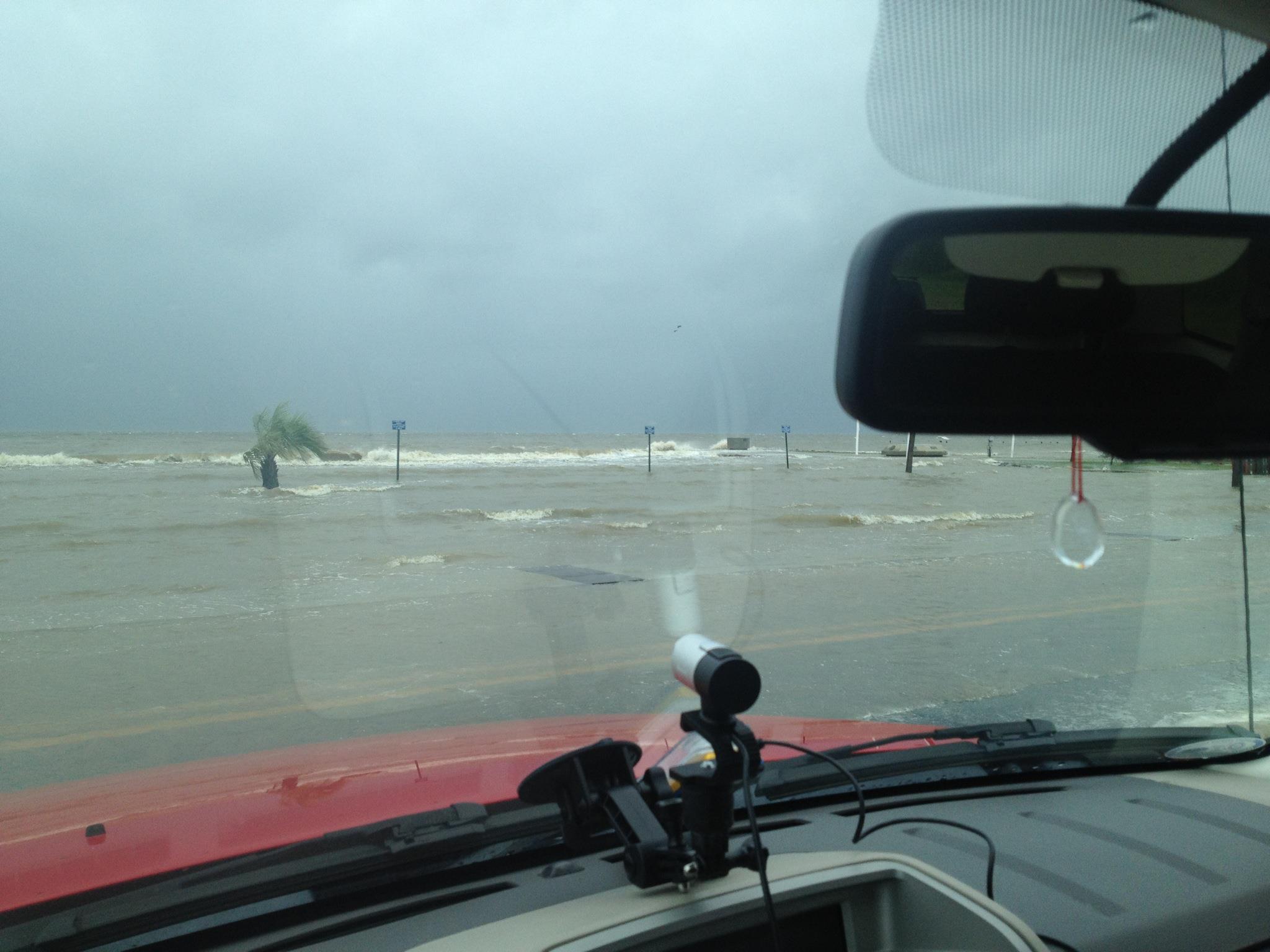
Posted: Aug 28, 2012, 10:22 AM
Surge covering highway 193 to dauphin isl.
Posted: Aug 28, 2012, 6:38 AM

Chicken and rice behind the wheel on I-10 near Pensacola :-)
Posted: Aug 28, 2012, 5:04 AM
Chris Collura updated his status.
Second chase of Isaac is on. Leaving Talahassee, FL and headed west towards Louisiana. The pressure of Isaac continues to drop, but will be a minimal hurricane at best (meh) ... Well I'm here and it is what it is. Sure beats sitting home and wishing I was here!
Posted: Aug 26, 2012, 9:16 PM
Chris Collura updated his status.
Wrapped up chase of strong Tropical Storm Isaac in Key West on Aug 26. Still watching where it's going the next few days.
Posted: Aug 26, 2012, 9:15 PM
Chris Collura added a new photo.

Waves from TS Isaac crashing over end of pier in Key West (Aug 26, 2012).
Posted: Aug 25, 2012, 8:32 PM
Chris Collura updated his status.
Planning on a trip to the FL Keys on Sunday (8/26) for Isaac. Live video stream should be running during the day (Sunday when available) - check the link here for it : http://www.livenewsvideonetwork.com/chris-collura-live-video/
Posted: Aug 25, 2012, 6:04 AM
Chris Collura updated his status.
Looks like a hurricane is on the menu for the middle and lower FL Keys late Sunday / Early Monday. Should make for a late evening intercept (leaving for the Keys Sunday AM early). Ofcourse, not skydiving today (solid mid-level rain shield won't allow that) ;-)
Posted: Aug 24, 2012, 7:08 PM
Chris Collura updated his status.
Watching the Miami LOSERS (aka 'Miami Dolphins football team') lose to Atlanta! What's up with Miami? Will a mile wide EF-5 hit Miami before the Dolphins win a super bowl (stupid question)?
Posted: Aug 24, 2012, 4:47 PM
Chris Collura added a new photo.

Eyeing Issac ... As of Aug 24 - Possible BUSY weekend / early week ahead!
Posted: Aug 24, 2012, 4:35 PM
Chris Collura added a new photo.
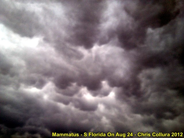
The boundary passed through S Florida on Aug 24 between the dry SAL layer and tropical air mass (containing TS Isaac within it). T Storms erupted near this wind shift line and presented a beautiful mammatus display at around 6:30 PM.
Posted: Aug 24, 2012, 4:23 PM
Chris Collura updated his status.
Tropical Storm Isaac is coming ... The next 12 hours will dictate how much disruption of the circulation occurrs as it passes over Eastern Cuba. After that, given an intact core structure, the storm can rapidly strengthen again in the Florida Straits. Plans are a Sunday (late) intercept in the FL Keys, then another possible chase (stronger storm) of a possible hurricane in the FL Panhandle. All this will be up to the "Cubans" at this point.
Posted: Aug 23, 2012, 3:13 PM
Chris Collura updated his status.
Tropical storm Isaac is struggling to develop in the E Caribbean Sea as Joyce formed in the tropical Atlantic. Isaac appears to be a more important storm for the Caribbean and Florida during the period from August 25-28 - Any intercept information will be a "treat"! Joyce should remain far out at sea and not intensify much. Isaac is questionable, and may actually weaken instead of strengthen (contrary to what forecasts show) - Hopefully not another "It's NOT '04" load of wank! Right now, from an "intercept" standpoint (in the world), Asia is the place to be.
Posted: Aug 22, 2012, 3:37 PM
Chris Collura updated his status.
Isaac is a real threat for at least a minimal hurricane for the area from the SE Gulf of Mexico through SE and S Florida by late weekend into early next week (August 26-27 being the "crunch time" as it appears now). I'm all set to chase it and enjoy!
Posted: Aug 22, 2012, 6:05 AM
Chris Collura added a new photo.
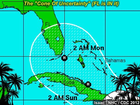
TS Isaac (Aug 22) Cone of Uncertainty (NHC) forecast. If this verifies, S Florida is the place to be!
Posted: Aug 21, 2012, 3:24 PM
Chris Collura updated his status.
Ah, new week (8/21) and more exciting possibilities. Tropical storm Isaac is in the tropical Atlantic and appears a good candidate for an intercept during the next week or so. At least the USA is "on the board" for this one. Then soon-to-be (Joyce?) is right behind Isaac. Should be very interesting. Meanwhile I'm keeping my IT contract going as well.
Posted: Aug 19, 2012, 5:26 PM
Chris Collura added a new photo.
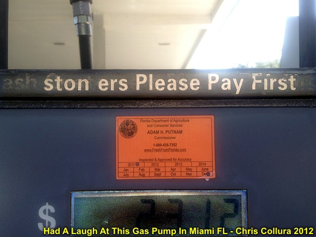
Someone took the sign saying "Cash Customers Please Pay First" and re-arranged it, even taking the "m" in "Customers" and making an "n" out of it to say "stoners Please Pay First"!
Posted: Aug 17, 2012, 4:10 PM
Chris Collura updated his status.
Severe storms in Broward County, Florida today (Friday). Meanwhile, two tropical storms, Gordon in the far N Atlantic (nearing the Azores) and newly formed Helene in the lower "arm pits" of the Gulf of Mexico (Bay of Campeche) that's too close to land to do anything but move on shore into Mexico early Saturday. The post '08 pattern continues!
Posted: Aug 17, 2012, 4:02 PM
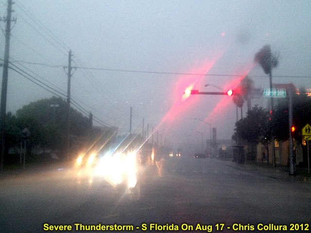
Chris Collura added a new photo.

Severe warned storm (Broward County, FL) on Aug 17, 2012. Gust front looking to the East.
Posted: Aug 17, 2012, 4:02 PM
Chris Collura added a new photo.
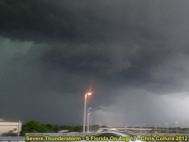
Updraft of severe storm on Aug 17, 2012 near Broward County in S FL. Note slight area of rotation (just above light pole). View is north.
Posted: Aug 17, 2012, 4:02 PM
Chris Collura added a new photo.
Winds up to 50 MPH, small hail, and heavy rain in Broward County, FL on Aug 17.
Posted: Aug 16, 2012, 2:57 PM
Chris Collura updated his status.
Hurricane chasing in 2012 is most likely gonna be a bust. Plans are possibly CHASING in the central USA for the SECOND season if El Nino verifies, screw the tropics (sorry, 2006 / 2009).
Posted: Aug 16, 2012, 2:52 PM
Chris Collura updated his status.
LOL ... Yesterday went to register a product at "profile.microsoft.com" and as of today, the long awaited and excitingly-anticipated "confirmation" email still has not arrived. Nothing - Not even in my SPAM folder.
The last time I had something like this was with my bank in '06 - Took over a MONTH to fix. Still waiting for this "confirmation" email to activate MS Visual Studio. Never came, maybe the email was hi-jacked?
I swear that ANYONE spoofing identity to STEAL someone elses - I'll find you and BREAK your little finders ONE by ONE ;-(
Posted: Aug 13, 2012, 7:22 PM
Chris Collura updated his status.
Atlantic tropics DEAD for a WHILE. Meh...
Posted: Aug 13, 2012, 5:24 PM
Chris Collura updated his status.
Gas prices keep going UP ... The USA has been far too nice (to those that wanna KILL us)!
Like my dad always yelled at me when I was a kid and come home beat-up : Learn who your true "friends' really are!
The "middle" east is SO MUCH like "middle" school - LOL!
Posted: Aug 13, 2012, 10:32 AM
Chris Collura updated his status.
8 years ago today (Aug 13) I was in the eye of hurricane Charley's 145+ MPH eyewall hanging on and getting some of the craziest footage I ever got from hurricane chasing! Today I'm getting brakes done and a couple of tires on a 'lighter' note :-(
Posted: Aug 13, 2012, 10:05 AM
Chris Collura added a new photo.

Posted: Aug 10, 2012, 3:52 PM
Chris Collura added a new photo.

Interesting "swirl" in the sky over S Florida on Aug 10, 2012 (after a round of sea-breeze thunderstorms). Mid-level "eddy" possibly?
Posted: Aug 10, 2012, 10:10 AM
Chris Collura added a new photo.

For all you older Techies out there ... Anyone remember what this listing of HEX code's from?
Posted: Aug 8, 2012, 9:13 AM
Chris Collura updated his status.
Ernesto was not intercepted by myself due to night landfall. Check out Josh Morgerman's posts on this system. He was the only one who chased this storm, and measured 975 mb in the center just after midnight on the night of Aug 7-8, 2012. I really wish this thing came in during the daytime. There may be some more tropical "possibilities" by late next week...
Posted: Aug 7, 2012, 1:27 PM
Chris Collura added a new photo.
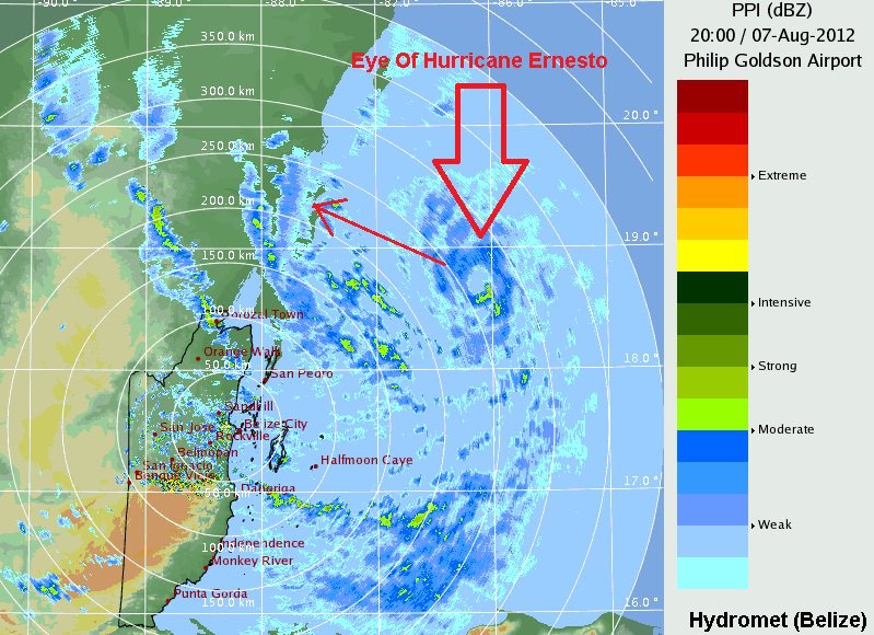
Hurricane Ernesto on the Belize Radar as seen approaching the Mexican coastline to the north (arrow). This is roughly 8-10 hour before landfall in Mexico's Yucatan Coast well south of Cancun during the night of Aug 7 to Aug 8, 2012.
Posted: Aug 7, 2012, 12:51 PM
Chris Collura updated his status.
Ernesto is now a hurricane (finally strengthened) as of late Tuesday (Aug 7). I am still not regretting cancelling the trip to Mexico because the storm is coming in at night and in a place with very poor coastal options.
I know of at least one chaser who made the trip there from California (Josh Morgerman). I hope he finds something there to share with the hurricane chasing community.
Gone are the days of '04 and '05 where hurricanes were so easy to chase and footage was awesome.
Posted: Aug 6, 2012, 6:28 PM
Chris Collura updated his status.
Wow ... Ernesto is really looking like shit now (8 pm)! Low shear, high heat content, diurnal max ... So what's killing it? I know ... All those people who got at each others throats in '04 and '05 (with video and rights) when hurricane chasing was 'easy' ... Maybe God saw that and said ... Ok ... No hurricanes for 10 years :-)
Posted: Aug 6, 2012, 11:46 AM
http://www.americanwx.com/bb/index.php/topic/35857-tropical-storm-ernesto-65-mph-994-mb-wnw-9-mph/
Posted: Aug 6, 2012, 8:40 AM
Chris Collura updated his status.
TS Ernesto SUDDENLY gets its act together ... Just hours after I missed my last opportunuty to fly over there to the Yucatan after a "no go" decision. The downer is that the storm looks more like it's gonna go into Chetamal. This is almost a 200 mile drive from Cancun and there are not many direct flights from Miami into there. I would like to see the system go a bit north towards the more "chaseable" areas on Mexico, with hotels (parking garages) and ocean "access".
Posted: Aug 5, 2012, 10:50 AM
Chris Collura updated his status.
TS Ernesto is still - Well - TS Ernesto. A repeat of 2006's Ernesto track, models and NHC thinks it would strengthen, and it simply doesn't. The "topside" of Ernesto looked good, but under that, dry air and bulk shear were eating away at it underneath (another reason I'm glad the Hurricane Hunters were not scrapped years ago).
Highly unlikely of a Yucatan chase now. Here we go - let the tropical "cock teases" of 2012 begin...
Posted: Aug 3, 2012, 6:11 AM
Chris Collura updated his status.
Right now, TS Ernesto is weak and needs to slow down to strengthen. It may present a hurricane chasing prospect for next week anywhere from the Yucatan area and into the Gulf Of Mexico.
The tropics are getting active, maybe FL and it's nasty people will be taught some sort of "sign", lesson, cleaning-house, or such this year ;-)
It's the weekend, and I'm focusing on visiting family and skydiving before possibly dealing with Ernesto next week.
Posted: Aug 1, 2012, 5:31 AM
Chris Collura updated his status.
Need 'cane ... Will travel!
Generated by Sky-Chaser Chris Collura on Wednesday, March 24, 2021 at 6:19 PM UTC-07:00
HTML File "indx1208.htm" (Facebook) - Developed By Chris Collura
To Return To The HOME Page Of This Site Click The "INDEX.HTM" Link Here!