
Facebook Timeline Posts For May 2012
(Posts And Comments During May 2012 For Sky-Chaser Chris Collura On Facebook)
[ 2012-JUN ] [ BACK TO INDEX ] [ 2012-APR ]
Posts And Comments For May 2012
Posted: May 31, 2012, 6:50 PM
Chris Collura added a new photo.
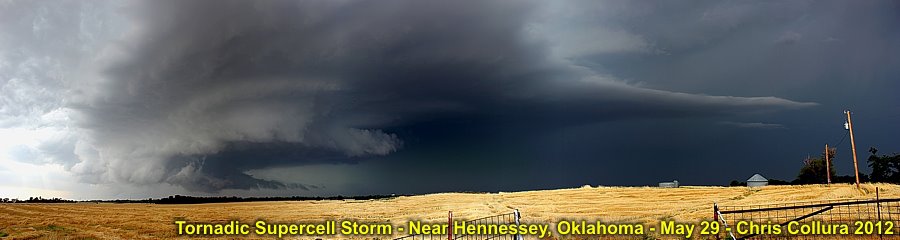
Panorama of the supercell near Hennessey, OK on May 29. This storm briefly produced a tornado, but the southern cell later near Piedmont was more powerful.
Posted: May 31, 2012, 12:55 PM
Chris Collura added a new photo.
Posted: May 31, 2012, 12:55 PM
Chris Collura added a new photo.

Posted: May 31, 2012, 11:16 AM
Chris Collura updated his status.
Taking down time today in Oklahoma City after chasing past few days. Tomorrow (Friday) looks good again in TX panhandle.
Posted: May 30, 2012, 8:18 PM
Chris Collura added a new photo.
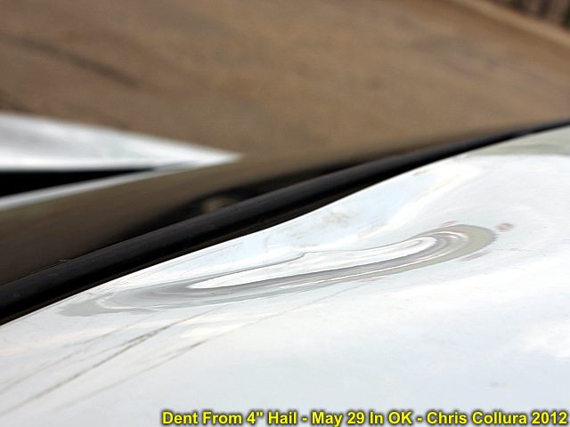
Dent from 4+ inch hail on May 29 near Piedmont, OK. How this did not take out the windshield is beyond me.
Posted: May 30, 2012, 8:18 PM
Chris Collura added a new photo.
Dent from 4+ inch hail on May 29 near Piedmont, OK. How this did not take out the windshield is beyond me.
Posted: May 30, 2012, 5:53 PM
Chris Collura updated his status.
Very tough day chasing because I was on the northern target! The southern target was the tornado producer ... Meh so sad! I guess I'm done as it should be quiet till & through sat. SPC was not the only one who blew that forecast!
Posted: May 30, 2012, 2:08 AM
Chris Collura added a new photo.
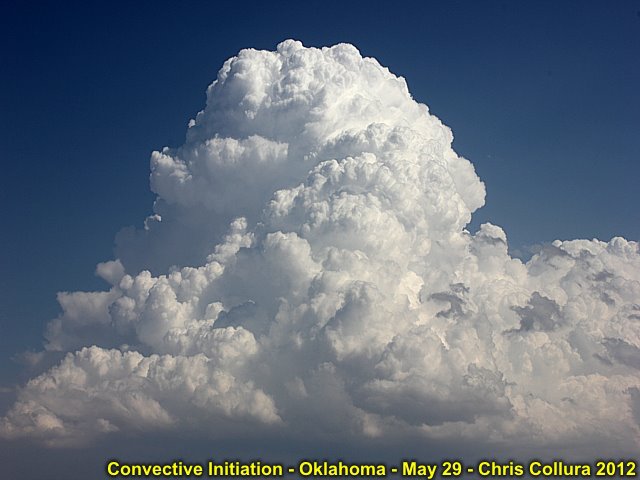
Cap is gone, and initiation underway on May 29 to the SE of Alva, OK.
Posted: May 29, 2012, 11:19 PM
Chris Collura added a new photo.
May 29 near Piedmont, OK ... This was one of the SMALLER pieces!
Posted: May 29, 2012, 11:19 PM
Chris Collura added a new photo.

Barely visible view of the Piedmont tornado through heavy rain and giant hail on may 29!
Posted: May 29, 2012, 11:19 PM
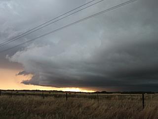
Chris Collura added a new photo.
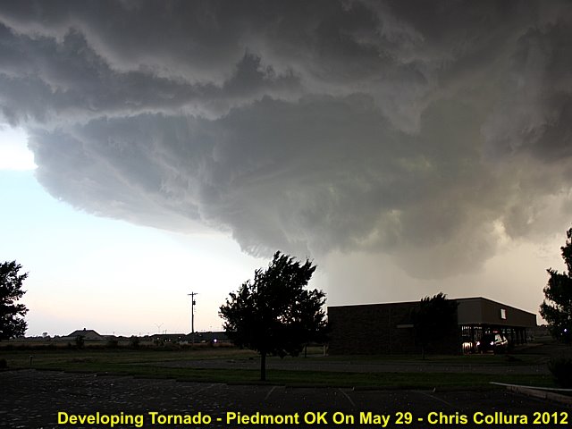
Tornado forming near Piedmont, OK on May 29 (with hail up to 5" falling)!
Posted: May 29, 2012, 11:19 PM
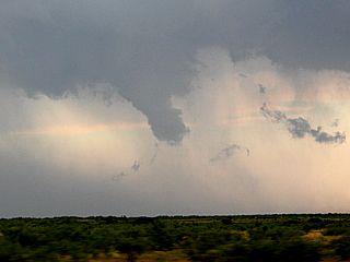
Chris Collura added a new photo.
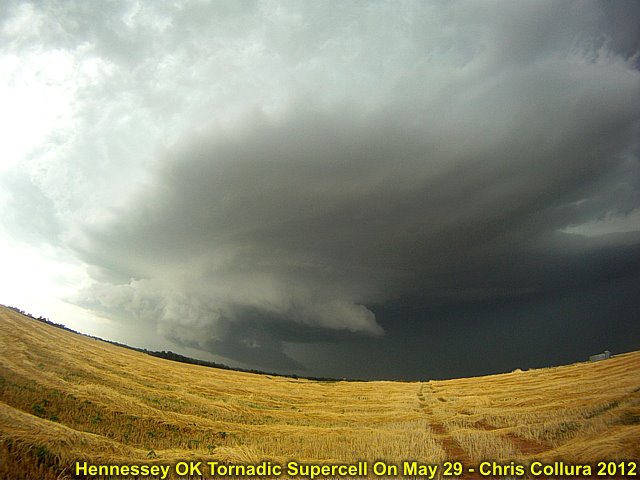
Developing tornadic supercell storm near Hennessey, OK on May 29.
Posted: May 29, 2012, 11:19 PM
Chris Collura added a new photo.
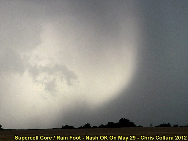
Intense rain foot from a supercell storm near Nash, OK on May 29.
Posted: May 29, 2012, 11:19 PM
Chris Collura added a new photo.
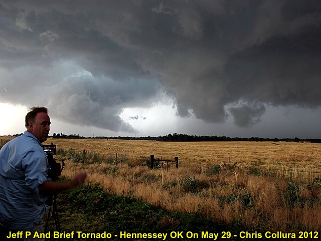
Jeff Pitrowski watching a brief tornado forming near Hennessey, OK on May 29.
Posted: May 29, 2012, 11:19 PM
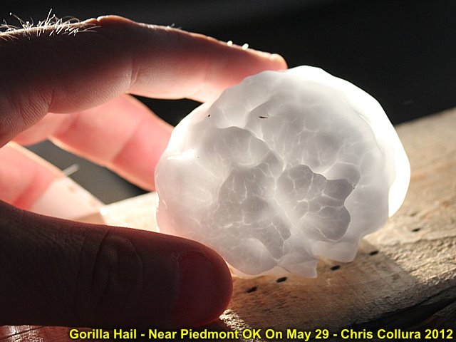
Chris Collura added a new photo.
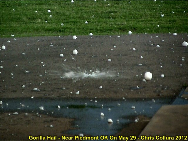
Gorilla hail falling near Piedmont, OK from a tornadic supercell storm on may 29. This hail whistled as it fell, and impacted like a shot-gun sound!
Posted: May 29, 2012, 6:59 AM
Chris Collura added a new photo.
Posted: May 29, 2012, 6:59 AM
Chris Collura added a new photo.

Posted: May 29, 2012, 6:59 AM
Chris Collura added a new photo.

Posted: May 29, 2012, 6:59 AM
Chris Collura added a new photo.
Posted: May 29, 2012, 6:59 AM
Chris Collura added a new photo.

Posted: May 29, 2012, 6:56 AM
Chris Collura added a new photo.

Posted: May 29, 2012, 6:56 AM
Chris Collura added a new photo.
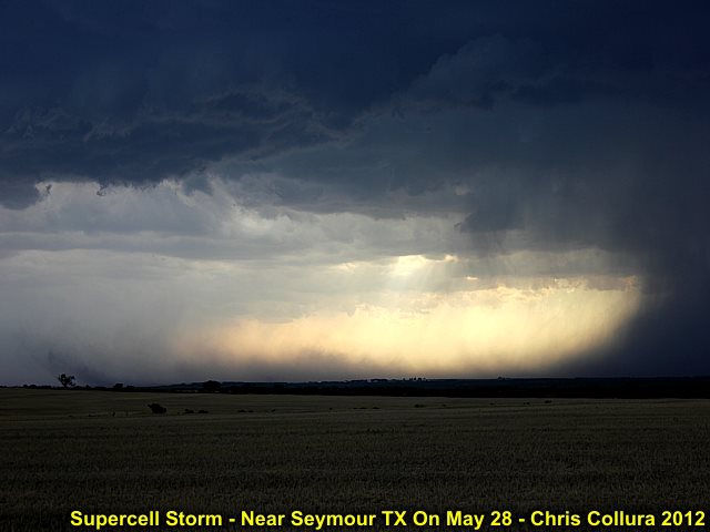
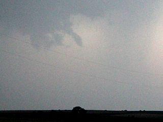
Posted: May 28, 2012, 11:27 AM
Chris Collura added a new photo.
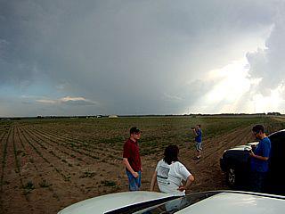
Posted: May 28, 2012, 11:27 AM
Chris Collura added a new photo.

Posted: May 28, 2012, 11:27 AM
Chris Collura added a new photo.
Posted: May 28, 2012, 11:20 AM
Chris Collura updated his status.
Back to OK / TX today May 28 then big setups next few days!
Posted: May 28, 2012, 11:18 AM
Chris Collura added a new photo.

Posted: May 28, 2012, 11:18 AM
Chris Collura added a new photo.

Posted: May 26, 2012, 10:25 PM
Chris Collura added a new photo.

Sunset and wind turbine east of Oniel, NE on May 26.
Posted: May 26, 2012, 10:25 PM
Chris Collura added a new photo.

Severe storm near Rochester, MN on May 26.
Posted: May 26, 2012, 10:25 PM
Chris Collura added a new photo.

Wisconsin landscape (May 25) while I was "stuck there".
Posted: May 26, 2012, 10:25 PM
Chris Collura added a new photo.

LP storm and wind turbine east of Oniel, NE on May 26.
Posted: May 26, 2012, 11:29 AM
Chris Collura updated his status.
Back in the NE / SD / MN Corner after the "BIG eff'up" ... Wont do that again ;(
I see 5% to 2% now on SPC ... Meh
Posted: May 25, 2012, 7:51 PM
Chris Collura updated his status.
Oh my ... Did I fuck up or what?
Friday morning I was in Wisconsin waking up at 11 AM and realized what I did.
Don't EVER - EVER go chase JUNK too FAR east.
So much for the see text. Anyway ... Going to bed (congrats guys). Hopefully see you all out there tomorrow.
Posted: May 25, 2012, 4:37 PM
Chris Collura updated his status.
Oh boy ... There it is - That lil' blip on radar in kansas ... Whoever made it back out there from Wisconsin yesterday (lucky) ... Prepare yourselves.
I'll turn my laptop back on when I am on my way to SW MN tomorrow (early). I guess you'll know there were lots of tornadoes if you look in room 311 at Motel 6 in Chicago and find a hole in the wall ;-)
Anyway, good luck to those out there ... I really eff'd up going to Wisconsin for the LAST time yesterday. Tomorrow's a good setup in MN and southward. Let's see. Maybe the day before the day (and today is the day-before-before-the day)!
Posted: May 25, 2012, 6:41 AM
Chris Collura updated his status.
Now the BURNING is expected today ... After chasing the junk / garbage too far to the NE in Wisconsin yesterday, I am here in Wisconsin today (this morning) on what was supposed to be an OFF day and some time to relax ... NOPE
... When I saw the 5% tornado bullseye in Kansas today (was a see text yesterday) now I learned to STAY AWAY from Wisconsin (it's like Michigan)!
I thought this would be just seeing crappy storms, but if something happens in Kansas today ... That would really be Wisconsin shoving it "up there" really hard.
Posted: May 24, 2012, 11:16 PM
Chris Collura added a new photo.
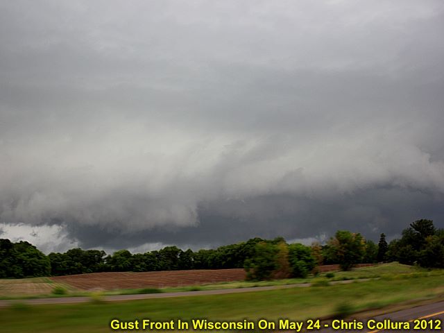
Wisconsin (near Eau Claire / Osseso) outflow-dominated severe storm on May 24.
Posted: May 23, 2012, 10:08 PM
Chris Collura added a new photo.

Another self-portrait of myself chasing with a wall cloud forming out the window (Nebraska on may 23).
Posted: May 23, 2012, 10:08 PM
Chris Collura added a new photo.
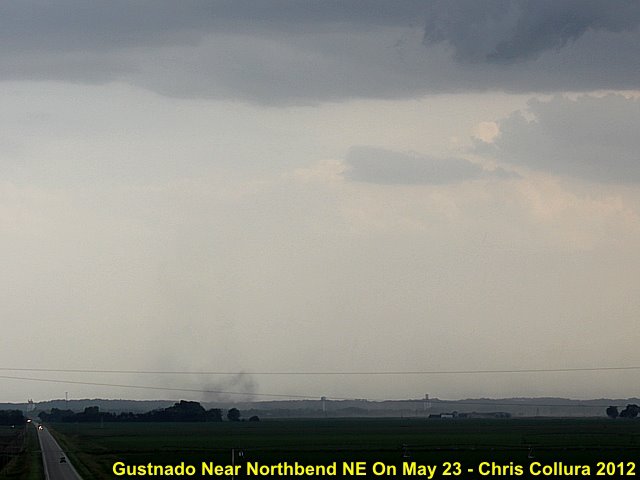
Gustsnado along RFD gust front of supercell storm north of Northbend, NE on May 23.
Posted: May 23, 2012, 10:08 PM
Chris Collura added a new photo.
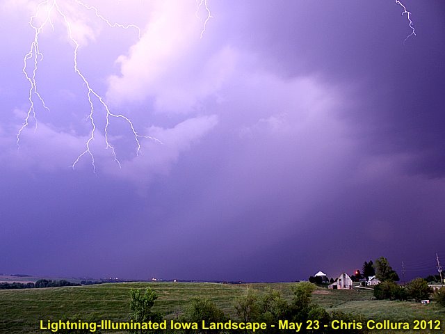
A big CG hits BEHIND me illuminating the landscape in western Iowa on May 23 at about 10 PM (the "forks" can be seen in the top of the photo)!
Posted: May 23, 2012, 10:08 PM
Chris Collura added a new photo.

Rotating wall cloud north of Northbend, NE on may 23.
Posted: May 23, 2012, 12:47 AM
Chris Collura updated his status.
Finished a LONG chase in North Dakota ... Supercell storms, then got to see the northern lights or the first time after sunset!
Posted: May 23, 2012, 12:47 AM
Chris Collura added a new photo.
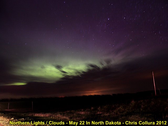
Looking northeast from near Fresseden, ND on May 22 ... I finally get to see the northern lights (and try to photograph them) for the first time in my life! Too bad the sky wasn't perfectly clear.
Posted: May 23, 2012, 12:41 AM
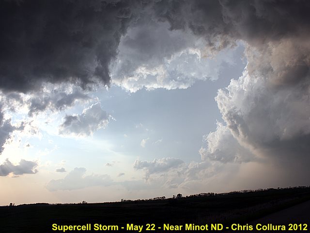
Chris Collura added a new photo.

Supercell storm north of Minot, ND at about 8 PM CDT on May 22 (the sun sets at 9:30 PM there)!
Posted: May 23, 2012, 12:41 AM
Chris Collura added a new photo.
Huge RFD clear slot of supercell storm north of Minot, ND - May 22.
Posted: May 23, 2012, 12:41 AM
Chris Collura added a new photo.

Supercell storm north of Minot, ND attempts to produce a tornado with a rapidly rotating wall cloud on May 22.
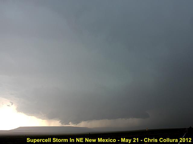
Posted: May 22, 2012, 7:34 AM
Chris Collura added a new photo.
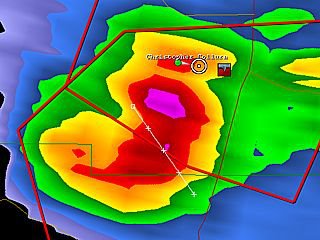
NE New Mexico - May 21, 2012.
Posted: May 22, 2012, 7:34 AM
Chris Collura added a new photo.

Posted: May 22, 2012, 7:34 AM
Chris Collura added a new photo.
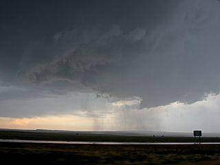
RFD and wall cloud "Bear's Cage" southwest of Springer, NM - May 21, 2012.
Posted: May 22, 2012, 7:34 AM
Chris Collura added a new photo.
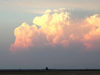
Supercell near Johnson, Kansas (May 21, 2012).
Posted: May 22, 2012, 6:29 AM
Chris Collura updated his status.
Made the long trip from NE New Mexico May 21 and arrived in North Platte, NE during the night (late). I am now in range for some of the storms expected today in the Dakotas (May 22)!
Posted: May 22, 2012, 2:31 AM
Chris Collura added a new photo.

Rotating wall cloud / funnels from supercell in NE New Mexico (just west of I-25 on Highway 56 near Miami, NM).
Posted: May 22, 2012, 2:31 AM
Chris Collura added a new photo.
Supercell near Highway 56 and I-25 in NE New Mexico.
Posted: May 21, 2012, 8:41 AM
Chris Collura updated his status.
Looks like a small chase today in and near the Texas / OK panhandles. Better than nothing!
Posted: May 20, 2012, 9:03 PM
Chris Collura updated his status.
Wrapped up a great day seeing the annular eclipse just west of Albuquerque, New Mexico from late afternoon to sundown. Well worth the 450 mile drive from Denver!
Posted: May 20, 2012, 9:02 PM
Chris Collura added a new photo.

Annular eclipse about 75% as seen through a dark-filter just west of Albuquerque, New Mexico during the late afternoon. Note the sunspots!
Posted: May 20, 2012, 9:02 PM
Chris Collura added a new photo.
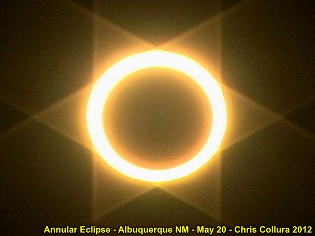
Full annular eclipse with "ring of fire" effect. The "star of David" is caused by the lens flare from a neutral density filter.
Posted: May 20, 2012, 9:02 PM
Chris Collura added a new photo.

Same eclipse about 95% seen through dark filter in new Mexico.
Posted: May 20, 2012, 9:02 PM
Chris Collura added a new photo.

Strongly dimmed sunlight with eclipse watchers (umbraphiles) lining the roadway atop a mountain west of Albuquereque, NM.
Posted: May 20, 2012, 9:02 PM
Chris Collura added a new photo.
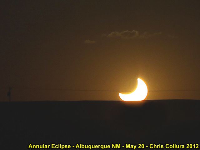
The sun set with about 50% partiality remaining (after total annular for about 4 minutes). Basically, it's HALF of a sunset!
Posted: May 19, 2012, 8:45 PM
Chris Collura updated his status.
I may have missed the tornadoes in Kansas / Nebraska today as I got in a bit late (May 19) but at least I saw the supercells from high up as turbulence rocked the plane.
Posted: May 19, 2012, 8:41 PM
Chris Collura added a new photo.
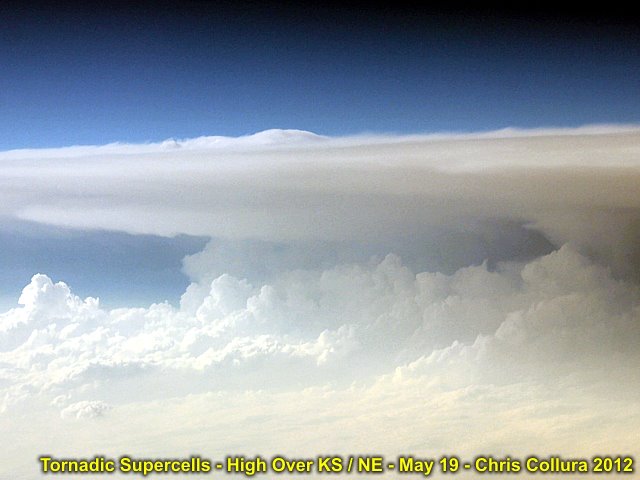
Over Kansas / Nebraska en route to Denver (from Chicago). Looks like a tornadic supercell viewed from high altitude to me! Picture taken May 19, 2012 at about 7 PM CDT.
Posted: May 19, 2012, 8:41 PM
Chris Collura added a new photo.
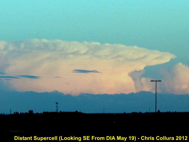
Distant view of supercell storm from near denver International Airport on May 19, 2012. View is to the SE of a storm at least 100 miles away.
Posted: May 19, 2012, 6:28 PM
Chris Collura updated his status.
Shit ... Why did I not get HERE a day sooner?
I'm in Denver (arrived) and I checked Kansas tornadoes and wanna vomit.
Oh well, tomorrow's the eclipse and hopefully storms next week.
Posted: May 19, 2012, 2:25 PM
Chris Collura updated his status.
Wow ... Tropical storm Alberto forms off the SC coast. Currently en route to see eclipse Sunday, hang out a bit, then chase mid week and after that.
Posted: May 17, 2012, 4:32 PM
Chris Collura updated his status.
I'm definitely liking the GFS showing a pretty major trough affecting the western USA from May 23 onward. Let's hope this verifies!
Posted: May 16, 2012, 4:49 PM
Chris Collura added a new photo.
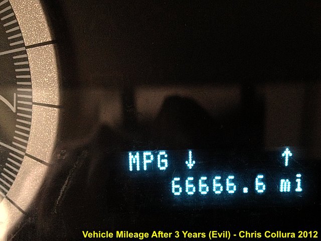
Odometer reading while stopped at a light in my 2009 Ford Escape ... Just like 2012, It's OK ... Went to 66,666.7 and NOTHING happened.
Posted: May 16, 2012, 9:11 AM
Chris Collura added a new photo.
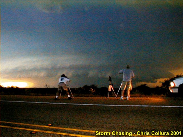
Rock Springs, Texas on May 24, 2001. HP supercell with Myself and Dave Cornwell in the foreground. @[1219789568:2048:Jeff Gammons] has taken the photo / video frame grab.
Posted: May 16, 2012, 9:02 AM
Chris Collura added a new photo.

Chasing in the good old days of "dialup" Internet and the price of fuel where it never will be again. This was near Aspermont, Texas in May 2001. Eric Nguyen's vehicle.
Posted: May 15, 2012, 6:12 PM
Chris Collura updated his status.
Just booked a two week trip to Denver, CO (fully flexible). I'll do the eclipse in New Mexico or points west, then take a break / hike for a day or so, then back to the US Plains for the trough next week.
Posted: May 15, 2012, 12:44 PM

WTF is going on with SW Airlines now? I found some awesome deals to fly out (Denver and even catch eclipse on 20th) on May 19 through 31 and I go to do a search, the little wheel goes rouind and round for a LONG time, and then THEIR system times out with an error message. Looks like their site crashed because they FINALLY lowered their fares and "everyone" hogged on it...
Posted: May 14, 2012, 9:59 PM
Chris Collura updated his status.
Big storms in Florida this week THEN ... It's finally showing up consistently - yes - strong jet stream winds straining over the E Pacific off California by Sunday. Looks like the US Plains may be 'on-line' by about early to mid week of May 23 or so.
Posted: May 14, 2012, 5:09 PM
Chris Collura added a new photo.
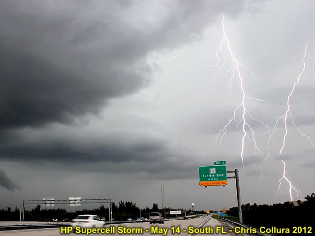
Intense positive CG's northeast of the severe storm west of Sunrise, Florida on May 14, 2012.
Posted: May 14, 2012, 5:09 PM
Chris Collura added a new photo.

Another intense CG to the northeast of the severe storm near Sunrise, FL on May 14, 2012.
Posted: May 14, 2012, 5:09 PM
Chris Collura added a new photo.
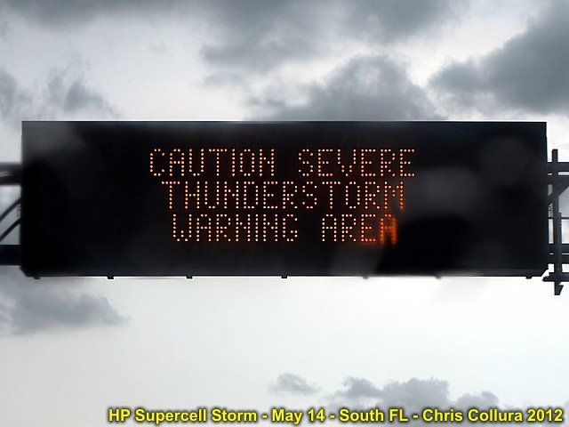
Traffic updates on a severe thunderstorm in the area. South Florida, May 14, 2012.
Posted: May 14, 2012, 5:09 PM
Chris Collura added a new photo.
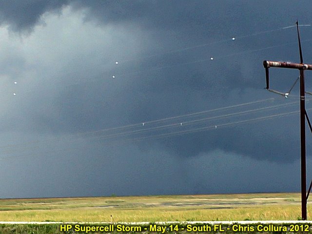
Not sure what this is, but it's in the correct place for a tornado! RFD cut to the upper left, lowering and "something" on the ground under it? Severe HP supercell storm over FL Everglades west of Sunrise on May 14, 2012. The view os to the NW.
Posted: May 14, 2012, 5:09 PM
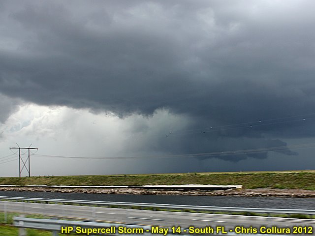
Chris Collura added a new photo.
Interesting view of the weakening mesocyclone (view is to WNW) associated with an HP severe storm west of Sunrise, FL (May 14).
Posted: May 14, 2012, 5:09 PM
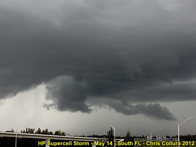
Chris Collura added a new photo.
View of HP supercell (looking NW) west of Sunrise, FL on May 14. Well-defined RFD clear slot and wall cloud with funnels.
Posted: May 13, 2012, 10:10 PM
Chris Collura updated his status.
Happy Mother's Day (Sunday) ... Did my usual skydive and visiting family this past weekend. Working a bit this week (obviously I won't be storm chasing for some time). Possible storm chase trip will be the following week only of the forecast models pan out.
Posted: May 13, 2012, 8:35 AM
Chris Collura added a new photo.
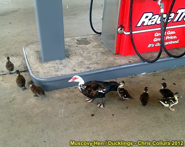
A muscovy hen duck and her adolescent ducklings waddling around a South Florida gas station.
Posted: May 13, 2012, 8:35 AM
Chris Collura added a new photo.
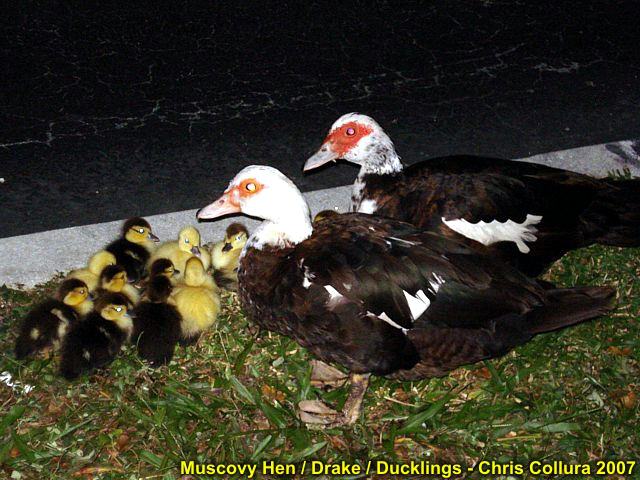
Ugly when they're old, adorable as babys (Muscovy ducks). The two adults are the male (drake to upper right) and female (hen duck to the left of the male).
Posted: May 11, 2012, 9:19 PM
Chris Collura updated his status.
About these "ChaseCations"...
ChaseCations (storm chaser vacations) are to be done with caution and (most importantly) flexibility. Murphey's law dictates that a two week "fixed" window (ESPECIALLY when dictated by your BOSS and / or - even worse - your WIFE) will put you in between activity and in a RIDGE.
Happened FIVE years in a ROW when I started chasing. It's HORRIBLE hearing other chasers say "Man, you SHOULD have been here last week" and you look at the ridge / Baja rex block going from "Analysis" to "240 HRs" out on all the models, knowing your bad luck and schedule just porked you!
Then it's mid-late May, and a cold front goes from Idaho to Florida in just 2 DAYS, cuz of the NW flow, and you get a squall line for 3 minutes, then the ridge continues, cold and raw weather - Your forced to buy a jacket, and ponder some more: "hey guys, lets go to Carlesbad Caverns today (sigh)..."
Oh, boy, you have 4 more DAYS left, and it's May 27. Still no storms to write home about. The wife calls from the East Coast each day telling you it's raining and storms there every day, and your "wasting your time". Then your other chase buddies, the same "should have been here last week" crowd, tell you, all the models are picking up and there will be storms "starting on June 1"!
But there you are, on June 1, then the 2nd, and all the way to the 17th ... Listening to your wife complain because you wasted 12 vacations days on nothing, and you are hopelessly watching tornado after beautiful tornado on Stormtrack and other Facebook posts!
I have been through this too ... Trust me, it's NOT fun looking at "rocks" or "national parks" over and over again ;-(
Posted: May 11, 2012, 7:36 AM
Chris Collura added a new photo.
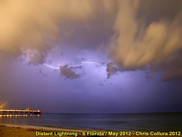
Actually NOT an HDR shot. This was a long 2 minute exposure over the ocean off Broward County, Florida on May 10 at about 10 PM, so the clouds are illuminated by light "pollution" and the CC lightning "filled" in the rest!
Posted: May 9, 2012, 10:07 AM
Chris Collura updated his status.
I see many chase trips (from several storm chasers) in the country's mid section with eh dreaded and all-too-familiar "ridge" activities (JFK's assasination area, Monuments, rocks, and such) ... I am so glad I am not out there the next week "finding" things to do. It appears that late may should be much busiest, from May 20 onward. Decided to work a few days this week to pass the time.
Posted: May 8, 2012, 4:47 PM
Chris Collura added a new photo.

Thunderstorms - South Florida (Sunrise) on May 8, 2012.
Posted: May 8, 2012, 4:47 PM
Chris Collura added a new photo.
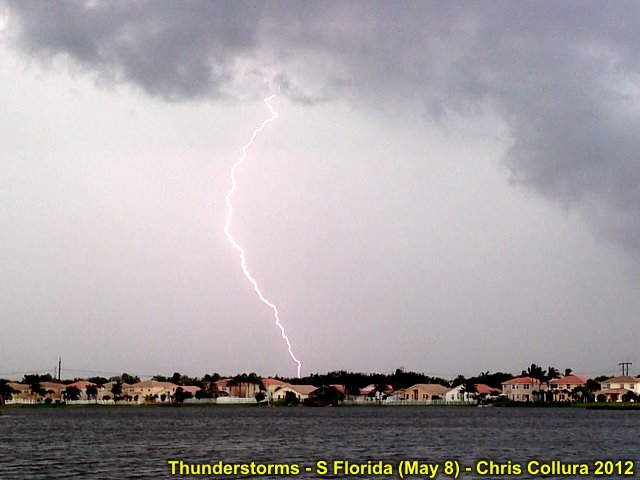
Thunderstorms - South Florida (Sunrise) on May 8, 2012.
Posted: May 7, 2012, 7:58 PM
Chris Collura added a new photo.
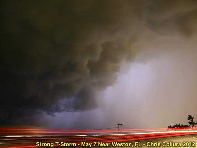
30 second time-exposure of a strong thunderstorm near Weston, Florida on May 7, 2012 (9:30 PM). I was "trying" to get some lightning bolts in there, but I was surprised to see this beautiful rain-free base and precip-core to its right!
Posted: May 7, 2012, 12:58 PM
Chris Collura added a new photo.

It's home-made (from 1/2" PVC tube + dremel). If you cannot find it (STAX-5 finger splint) - Make it!
Posted: May 7, 2012, 10:36 AM
Chris Collura added a new photo.
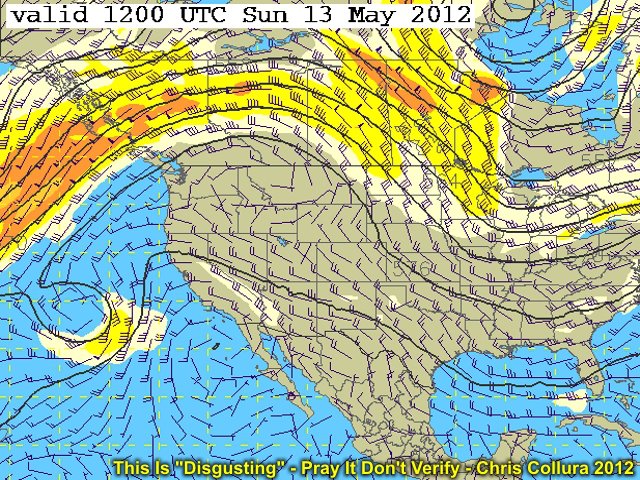
This is what the GFS is showing (as of May 7) for a week out ... This is definitely NOT something us storm chasers want to see for the rest of May. Hopefully this will pass and / or not verify...
Posted: May 7, 2012, 10:29 AM
Chris Collura updated his status.
I am definitely NOT liking the long-range pattern for the next 10 days in the central USA. I really hope this does not verify. That all-too-familiar "2009" ridge appears to be setting up with a split flow (jet streams over Canada and Mexico) with that dreaded Baja (Rex block) low and Hudson Bay (trough-east) pattern. NO chasing for at least 10 days is likely. Hopefully, late May will turn around. If you are chasing in the central USA for the next 2 weeks ... Either cancel / reshedule it ... Or plan on a good chance you'll be seeing A LOT of national monuments, Carlesbad Caverns, and non-weather related stuff ;-(
Posted: May 7, 2012, 9:30 AM
Chris Collura added a new photo.

Baseball finger sucks ... Need to have this on for 6-8 WEEKS? No ... This was NOT from skydiving...
Posted: May 7, 2012, 8:36 AM
Chris Collura added a new photo.
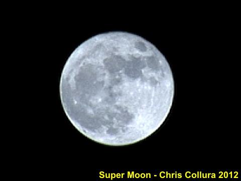
Moon on May 5, 2012 ... Big full moon - About 15% larger at a 221,000 mile distance (Perigean).
Posted: May 3, 2012, 4:28 PM
Chris Collura updated his status.
The "promising" setup early next week in the central USA not looking so "promising" now as per the models. I see a front going all-the-way through and leaving the upper support over the cold sector. Eyeing up next week for chase possibilities / start of main MAY chase trip soon.
Posted: May 2, 2012, 9:54 AM
Chris Collura wrote on Karl Kouns's timeline.
Please don't send me these "app requests" (cityville, farmville, etc). I do not use them.
Posted: May 2, 2012, 7:22 AM
Chris Collura added a new photo.

LOL ... Didn't SPRING BREAK end in April?Like "gas prices" ... Raise a price, people get "used to it" being high and then you don't have to lower it after the "cause" of the increase goes away. Lobbying sucks - Doesn't it!
Posted: May 1, 2012, 12:32 PM
Chris Collura updated his status.
I see a potential multi-day severe weather setup starting this coming Sunday ... Time to check airline tickets again ;-)
Generated by Sky-Chaser Chris Collura on Wednesday, March 24, 2021 at 6:19 PM UTC-07:00
HTML File "indx1205.htm" (Facebook) - Developed By Chris Collura
To Return To The HOME Page Of This Site Click The "INDEX.HTM" Link Here!