
Facebook Timeline Posts For March 2012
(Posts And Comments During March 2012 For Sky-Chaser Chris Collura On Facebook)
[ 2012-APR ] [ BACK TO INDEX ] [ 2012-FEB ]
Posts And Comments For March 2012
Posted: Mar 31, 2012, 7:10 PM
Chris Collura updated his status.
Just had the hurricane chasing party / gathering at Jim Leonard's new place in Boynto Beach. Very well done to Jim again and thanks! Great and interesting folks doing what we all do best (storm / hurricane chasing)!
Posted: Mar 24, 2012, 6:09 PM
Chris Collura added a new photo.
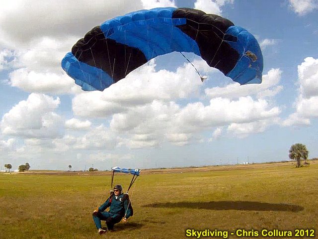
Back to earth!
Posted: Mar 21, 2012, 11:39 AM
Chris Collura added a new photo.
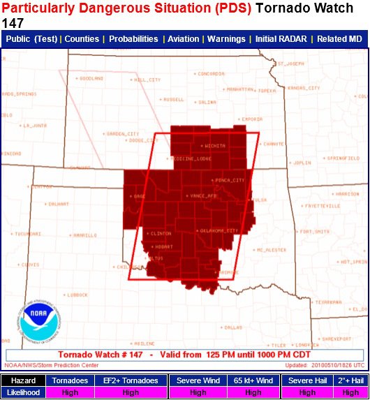
The "Max'ed Out" of a PDS weather watch box (May 10, 2010 OK high-risk)...
Posted: Mar 21, 2012, 6:00 AM
Chris Collura updated his status.
Today's expression: NO good deed goes un punished.
Posted: Mar 20, 2012, 7:13 AM
Chris Collura updated his status.
Remember "Whack-A-Mole" ... Keep hitting a head that "pops" up and another comes up some where else?
That's what work is like this morning, Boss's out (again) and I'm here alone. Putting out fires (problems) and never getting actual programming done.
So funny seeing 2 helpdesk tickets, I address both, and before even exiting the helpdesk app, I see two more pop up (while I was editing the original 2)!
Whack-A-Mole!!
Posted: Mar 19, 2012, 5:19 PM
http://www.sky-chaser.com/drawing/spring07.jpg
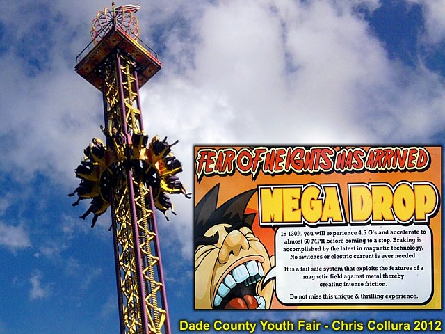
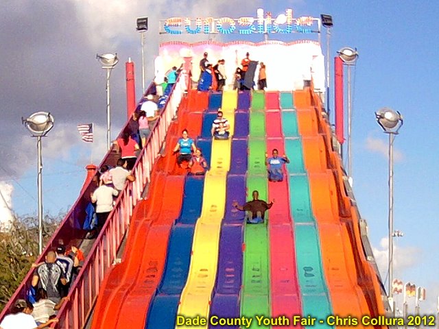
Posted: Mar 19, 2012, 5:09 PM
Chris Collura updated his status.
Never too old to enjoy the county fair!
Posted: Mar 19, 2012, 5:00 PM
Chris Collura added a new photo.

Posted: Mar 19, 2012, 5:00 PM
Chris Collura added a new photo.
Posted: Mar 19, 2012, 4:59 PM
Chris Collura added a new photo.
Posted: Mar 19, 2012, 4:58 PM
Chris Collura added a new photo.

Baby White Pekin ducklings.
Posted: Mar 19, 2012, 4:58 PM
Chris Collura added a new photo.

Posted: Mar 19, 2012, 4:58 PM
Chris Collura added a new photo.

Posted: Mar 19, 2012, 4:58 PM
Chris Collura added a new photo.

Posted: Mar 19, 2012, 8:21 AM
Chris Collura updated his status.
Didn't get to chase the stuff Sunday this time but kinda glad I did not ... The target would have been W / Central KS. I cannot imagine spending all the $$ and such going into Kansas City, then being in W Kansas and seeing the only really good daylight storm in SW OK 250+ miles to my SW (and later another near N Platte NE 200 miles the other way after dark)! Right now I'd be rushing back to work, bummed. I see many were in Kansas and busted (only some small LP's) Sometimes that's worse than NOT going at all.
Posted: Mar 17, 2012, 3:23 PM
Chris Collura updated his status.
Such a good feeling dropping through the sky from 14,000 feet at 167 MPH on a clear Saturday!
Posted: Mar 16, 2012, 4:57 PM
Chris Collura updated his status.
No KS / NE chase this weekend ... Pattern looking better, but there are simply no flights!
At least the skydiving is still $25 a jump (spring break OR not)!
Posted: Mar 16, 2012, 4:04 PM
Chris Collura added a new photo.
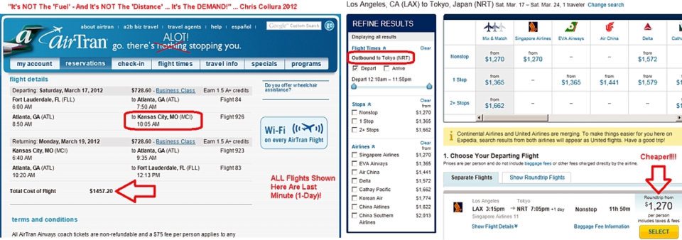
I thought I'd post this as it shows the funny effects of demand versus actual supply and other factors, such as the price of gas! If I wanted to fly from Fort Lauderdale to Kansas City in mid March 2012 (a place normally very cheap to fly into) ... It would cost me nearly 1,500. This is due to peak travel / spring break. In comparison ... For the SAME last minute date, a trans-Pacific flight from Los Angeles to Tokyo, Japan would cost $200 less. This goes to show you how business can work sometimes!
Posted: Mar 16, 2012, 2:08 PM
Chris Collura added a new photo.

Can't wait for THIS to end...
Posted: Mar 16, 2012, 11:32 AM
Chris Collura updated his status.
Just learned that I cannot use any free tickets due to extreme "peak" travel. So I'll have to sit this weekend setup (3-18) out, unless I want to spend a grand just in airfares. April looks much better ... Just too many special events (teens, spring break, NCAA, St Pat's day, etc) going on.
Never had a problem using tickets like that before, but I guess even SW is cracking down on that too. Real bummer. Sucks when you want to go somewhere and events totally unrelated to your trip mess it up. Reminds me of March of 2008, when I was working in Chicago, and during spring break a $200 ticket was $1200.
Good luck to all who make it out there...
Posted: Mar 16, 2012, 6:59 AM
Chris Collura updated his status.
Still eying up Sunday's setup in central USA (March 18). I can get out Sat night and come back Monday early. There are two issues with this, however.
Number one, it's Spring Break, and tickets at $600+ EACH way to and from MCI (Kansas City) and Florida. Other cities simply are sold out and NCAA doesn't help either. I DO have an anytime free ticket with Southwest (saved especially for "Spring Break deal-busting" situations like this), so this really isn't much of a problem.
Second, the negative tilt trough may actually be TOO strong, arriving over the plains LATE Sunday and as more of a squall line than tornado producing supercells. Winds are due south at the surface, but remain due south to slightly SSW all the way up to 250 MB. This is fast-moving storms and a squall line.
I'll look at this more on Saturday Morning and see what it looks like before making "Go" or "No Go" decision.
Posted: Mar 16, 2012, 6:20 AM
http://www.redbullstratos.com/media/38529-STM_US_BAUM_JN_0001.jpg
Posted: Mar 15, 2012, 4:19 PM
Chris Collura added a new photo.
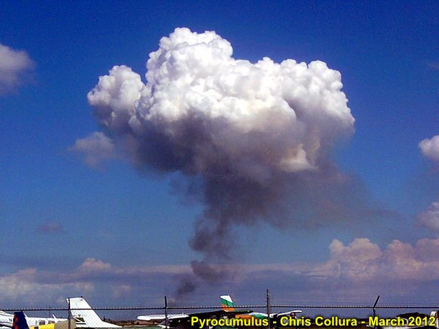
Pyrocumulus over Clewiston, FL. These cumulus clouds form over the hot thermals of a brush fire (in this case, sugar cane burning). Pyro means "fire".
Posted: Mar 15, 2012, 4:19 PM
Chris Collura added a new photo.
Strong thunderstorm in Broward County, Florida - March 15, 2012.
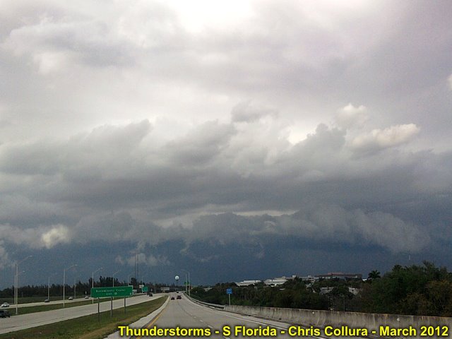
Posted: Mar 15, 2012, 4:19 PM
Chris Collura added a new photo.
"Whale's mouth" on backside of gust front with a strong thunderstorm in Broward County, Florida - March 15, 2012.
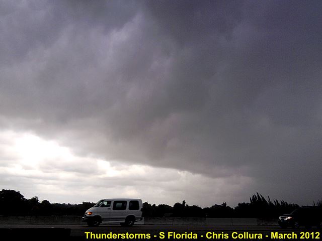
Posted: Mar 15, 2012, 4:19 PM
Chris Collura added a new photo.

Strong thunderstorm and gust front / shelf cloud in Broward County, Florida - March 15, 2012.
Posted: Mar 15, 2012, 9:26 AM
Chris Collura updated his status.
Big thunderstorm going on now in Hollywood, FL ... Lightning hit the building I work in!
Posted: Mar 15, 2012, 8:21 AM
Chris Collura updated his status.
Nice dentist visit this morning, 25 minute root canal ... Pain's gone, thank God!
Posted: Mar 14, 2012, 1:20 PM
Chris Collura updated his status.
Toothache today, 'Dentistry' tomorrow morning ... Hopefully some relief.
Eyeing up potential SVR event in cental USA this coming Sunday. I see a S-N (meridonal) flow from 850 MB all the way to H25 level (250 MB). Not much veering and linear forcing (with storms moving N at 50 knots) at this time. Still 4 days out.
April and May certainly will be interesting. I already have last 2 weeks in May OPEN for Vacation (if I'm still working by then). Pary at Jim L's place in Boynton Beach coming in about 2 weeks (end of March).
Posted: Mar 12, 2012, 9:38 AM
Chris Collura updated his status.
iPod touch from nearly 2 years ago sold for $150. Maybe get an iPhone next month. Funny thing is I sold my 80 GB iPod classic back then for about $90, got the iPod touch for about $260 so after selling it it only "costed" me about $20 over that 2-year period. Amazing how slowly Mac stuff "depreciates".
Posted: Mar 6, 2012, 6:59 PM
Chris Collura updated his status.
Just donated $100 to US Red Cross (tornado disaster relief) ... Makes me feel a "little" better.
Posted: Mar 5, 2012, 5:11 PM
Chris Collura added a new photo.

Funny seeing this on TV while at the airport on March 2 - Just a week after "partying" with Jeff P at NSCC. Small world when it comes to storm chasing!
Posted: Mar 5, 2012, 5:10 PM
Chris Collura added a new photo.
Posted: Mar 5, 2012, 5:10 PM
Chris Collura added a new photo.

Posted: Mar 5, 2012, 5:09 PM
Chris Collura added a new photo.

KSC (Florida) and VAB (spece vehicle assembly building).
Posted: Mar 5, 2012, 5:09 PM
Chris Collura added a new photo.
Miami, FL while on final approach.
Posted: Mar 5, 2012, 5:09 PM
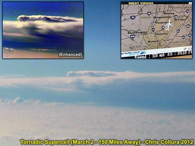
Chris Collura added a new photo.

Close-up of a tornadic supercell (at 150 to 200 mile distance) on March 2, 2012 ... About the same time this storm was producing tornadoes, and killing dozens of people ;-(
Posted: Mar 5, 2012, 5:09 PM
Chris Collura added a new photo.
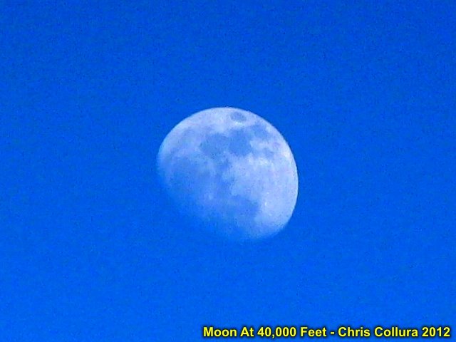
Moon viewed from aircraft at high altitude (near 40,000 feet).
Posted: Mar 5, 2012, 5:09 PM
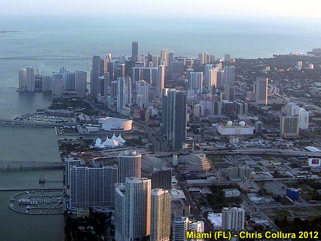
Chris Collura added a new photo.
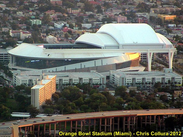
Miami's Orange bowl stadium viewed during final approach to Miami International airport.
Posted: Mar 5, 2012, 5:09 PM
Chris Collura added a new photo.
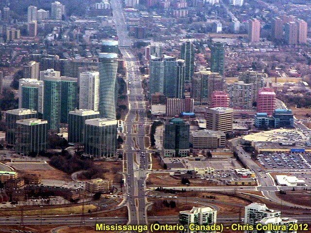
Mississauga in Ontario, Canada viewed just after departing Toronto's Pearson International airport.
Posted: Mar 5, 2012, 3:35 PM
Chris Collura updated his status.
God bless all those affected (Indiana, Kentucky, etc) by the tornado outbreak Friday (Mar 2). Seeing this subtle storm from above from an airplane, and not realizing over three dozen people were under it dying. Very sad. One story of a baby landing 10 miles away in a field, after both parents killed, then dying days later on life support ... Mother nature is a real prick sometimes, isn't she?
Posted: Mar 4, 2012, 5:37 PM
Chris Collura added a new photo.
View looking west at the supercell storm (from an airliner about 39,000+ feet and 150 miles to the east) ... This was about the same time this storm was causing death / destruction with tornadoes during March 2, 2012 tornado outbreak.
Posted: Mar 2, 2012, 5:59 PM
Chris Collura commented on JD Spinks's post.
Posted: Mar 2, 2012, 4:05 PM
Chris Collura updated his status.
Here in Toronto. Got a really good view of that Louisville storm from 40k and about 150 miles to the east. Top was muCh higher than flight level!
Posted: Mar 2, 2012, 9:26 AM
Chris Collura updated his status.
I am out of the loop for a few hours while I fly OVER the eastern edge of this stuff. Hopefully this won't be a deadly outbreak.
Posted: Mar 2, 2012, 9:18 AM
This is the FIRST cell to really watch!
Posted: Mar 2, 2012, 9:11 AM
Chris Collura updated his status.
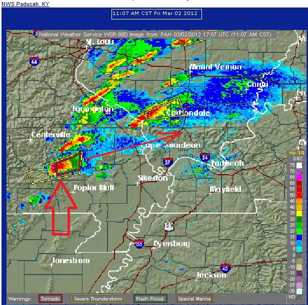
Cape Girardeau looks to be directly in the path of the intense storm.
Posted: Mar 2, 2012, 9:09 AM
Chris Collura updated his status.
There are apparently TWO "hot spots" of severe weather today (March 2). The one in Western KY / IN area, and another south near TN / AL. We already had tornado damage in AL as of noon. There is another "tail-end" cell moving from SE MO into IL near Cape Girardeau. This may become a "Yazoo like" storm (silimar to the one on Apr 24, 2010 in MS) being the southern storm and "virgin air" ahead of it. Be safe out there - Everyone, chasing or not!
Posted: Mar 2, 2012, 6:54 AM
Chris Collura updated his status.
There is a high-risk of severe weather and tornadoes in the north-central Kentucky area surrounded by a large moderate-risk. This setup is dominated by moderate instability but extreme shear and very strong winds (100+ knots) at nearly all levels of the atmosphere. I would best compare this to the "Super Tuesday" event in TN in Feb 2008 (but a bit farther north). Chasing this fast moving storms is all about "passing" the storm in an intercept and hoping you get a good view of the tornado (and not be between storm "cycles"). Once you are behind it, it's gone. Get in it's path = Pray hard!
Generated by Sky-Chaser Chris Collura on Wednesday, March 24, 2021 at 6:19 PM UTC-07:00
HTML File "indx1203.htm" (Facebook) - Developed By Chris Collura
To Return To The HOME Page Of This Site Click The "INDEX.HTM" Link Here!