
| This area shows pictures taken from the observations of hurricane Sandy during its closest approach to the eastern coastal sections of the state of Florida as well as some of the destructive marine effects felt from this storm. Sandy began as a tropical wave that entered the eastern Caribbean early during the week of October 22, 2012. The storm intensified to a tropical storm, then a hurricane, crossing Jamaica and eastern Cuba as a strong Category one hurricane. The storm passed through the eastern Bahamas as a category two storm before merging with an upper air low around October 25. This caused the hurricane to acquire subtropical characteristics, with a very wide wind field that expanded as the storm winds decreased to category one speeds while off the SE US coast. The storm produced tropical storm forced winds in Florida during its closest approach, and battered the region with very high waves. The waves, surge, and winds continued to expand in coverage from October 28 onward, with the storm passing east of Cape Hattaras and making a left turn back to the NW as it became a 90 MPH extratropical storm just off New Jersey on October 29. The storm made landfall later that same day causing extensive flooding and wave damage to New England and the eastern Seaboard from Florida to Canada! The storm continued inland, as a post-tropical storm, and caused snow and blizzard conditions in West Virginia areas. Observations of this dangerous storm system were mainly coastal and fringe effects of the winds as it passed Florida. |
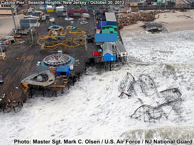
Hurricane Sandy was a storm of extreme size and with devastating effects that spanned an area nearly 1,150 miles across during its rampage through the north Atlantic as a subtropical system. It was the largest hurricane (size-wise as of October 29) ever observed in the Atlantic Basin as of 2012. The storm caused at least 253 deaths and over $52 billion dollars in damage, making it the second costliest hurricane since Katrina in 2005. Albeit not a strong system (winds were up to 110 MPH near Cuba when the storm was fully tropical on October 24-25 but remained 80 to 90 MPH as it was subtropical off the US East Coast on October 27-29), but it's immense size was a big problem. Most damage was from flooding, waves, and storm surge. The storm became extratropical late on October 29 as it came into southern NJ, with its winds and waves affecting the most densely populated urban areas in the US. After its rampage ashore in the mid-Atlantic, the storm continued NW, affecting the Great Lakes and dumping nearly 3 feet of snow in West Virginia and the Appalachians. In the image above, taken from a rescue mission by Sgt. Mark C. Olsen with the U.S. Air Force aboard a 1-150 Assault Helicopter, shows the Casino Pier at Seaside Heights, New Jersey disintegrating and falling into the violent surf. This frightening coastal scene was a common sight along the East coast of the US from Maine to even Florida during Sandy.
| CHASER NAME | HOME CITY | CALLSIGN | OCCUPATION |
| CHRIS COLLURA | SUNRISE, FL | KG4PJN | COMPUTER ANALYST |
| JEFFERY LAM | SUNRISE, FL | N/A | PROFESSIONAL SERVICES |
The list above shows personnel who actively participated in this chase / observation, including myself. Jeffrey Lam accompanied me to help with video and documentation of a portion of the coastal observations conducted during the passage of Hurricane Sandy from October 26 through 28, 2012.
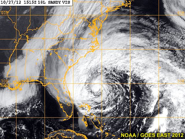
This is a satellite image (visible channel) of Hurricane Sandy as of the midday hours on Saturday, October 27, 2012. The storm clearly has a subtropical appearance, with a large clear air slot of dry air wrapping around the storm system from the west and southwest. The storm center, however, has deep convection and a central-dense-overcast (CDO) that denotes a hurricane type structure AT THE SAME TIME as the storm exhibits and "extratropical" storm structure along its edges. This area is very large, with a very large gale (tropical storm) forced wind envelope surrounding a small tight speed max about the hurricane core. This storm (hybrid) or "subtropical" structure is very reminiscent of the "perfect storm" back in 1991. These storms are extremely dangerous to shipping / coastal areas because of the large fetches of strong winds due to the extreme size of the storm.
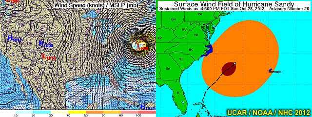
The two images above show both the forecasted (rapid-update cycle) pressure structure (left image) and surface wind field (right image) of Hurricane Sandy as of late October 27, 2012. The pressure (MSLP) presentation is denoted by many, many isobars surrounding a deep (but broad) storm center of lighter winds (about a pressure center as low as 940 MB)! Note the tight gradient of pressure developing west of the storm due to a Canadian (Ontario) high pressure area building well to the northwest of the storm. To the right, an exceptionally large area of gale / tropical storm forced winds (38 MPH and up) surrounds a rather small area (relatively speaking) of hurricane forced (74 MPH and up) to the SW of the storm center. At one point, the tropical storm forced winds extended nearly 570 miles from the center, with the hurricane forced winds extending out 150 miles or so in an asymmetric fashion. The storm wind envelope extends from inland NC well offshore past Bermuda - Impressive!
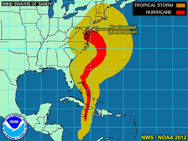
This is an image of the wind history / swath map during the lifetime of hurricane Sandy. Note that the storm has a "normal" size as it crossed Jamaica and Cuba and the southern Bahamas as a fully TROPICAL system. After that, around October 26 or so, the storm began to expand in size dramatically as it weakened (from a category two to a category one hurricane) and acquired subtropical / hybrid attributes. The storms journey continued northward, then northeast, and - quite strangely for late October - Back to the northwest towards the northeastern and mid-Atlantic USA late in the period (October 28-29). The storm evolved to a fully extratropical cyclone on October 29 as it was making landfall near Cape May, New Jersey on the north side of the Delaware Bay. As one can imagine, given the tremendous wind field and persistent strong winds, as well as the storm coming in through MULTIPLE tide cycles during a full moon AND perigee (moon's closest orbit to earth is also in late October) phase, the storm surges were devastating - With parts of New Jersey exceeding historic heights of 13 feet. The most damaging effects were felt from Maine to Florida, with devastation from Massachusetts to Delaware. Farther inland, as an extratropical storm, several FEET of snow fell over the Appalachians!
|
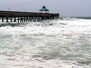
Tropical storm forced winds from 35 to 45 MPH affected the Palm beach and Broward County areas, especially along the coast, on October 25-26, 2012. This was when the storm was passing east of Florida and in the Northern Bahamas. In this picture, strong winds and large waves to 10 feet affect Deerfield Beach, Florida. |

|
As hurricane Sandy pulled away from Florida a bit, the dry air slot passed over, but the edge of the cirrus outflow canopy made for a very striking appearance in the sky over Palm beach, FL on October 26 and 27. Note the visible satellite image above ... The "edge" of the storm crossing eastern Florida in that picture was about the same time this picture was taken. |
|
Large breaking waves crash over the seawall on the northern side of Boynton Inlet on October 26, 2012. Winds also were at about 35 to 45 MPH from the north, with waves 8-12 feet. |
|
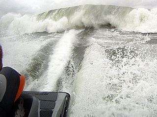
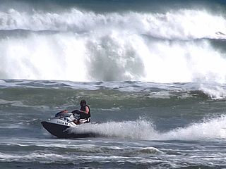
View is a large breaking wave off Boynton Beach, Florida from a SeaDoo personal watercraft during the afternoon of October 26,2012. The wave here is at least 10 feet high. |
|
Another view is a large breaking wave off Boynton Beach, Florida from a SeaDoo personal watercraft during the afternoon of October 26,2012. The wave here is about 12 feet high. |
|
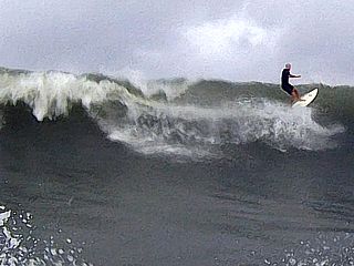
Tow-in surfer (towed by another personal watercraft) to catch a large breaking wave off Boynton Beach, Florida during the afternoon of October 26,2012. The wave here is at least 10 feet high. |
|
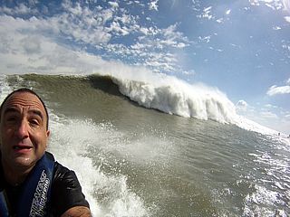
Here is another view showing a 12-15 foot breaking wave just south of Lake Worth Inlet (off "Reef Road") in Palm Beach, Florida on October 27,2012. The water is not dirty, that's sand and silt kicked up by the highly agiatated swell and wind-whipped seas as hurricane Sandy passed by. |
|
This was a picture shot from the beach of Boynton Inlet Park on October 28, 2012 as I was attempting to make my way out of the inlet. It was very difficult as the waves were out of control (10-15 feet, or higher) and there was too much debris (logs, flotsam, pieces of piers / boats, even a bench) floating in the water. |
|
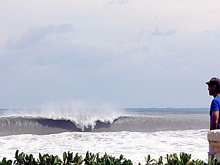
Here is a picture of a large wave breaking offshore near Reef Road south of Lake Worth inlet in Palm Beach County, Florida on October 27, 2012 as a local resident watches. |
|
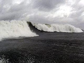
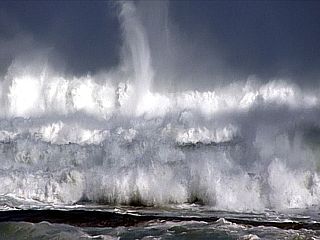
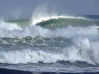
One large set of swells breaking off Boynton Beach, Florida on October 28, 2012 exceeded 15 feet high. The entire ocean became "white to the horizon", with thrashing and violent water. This was about the time low tide changed over to incoming tide. |
|
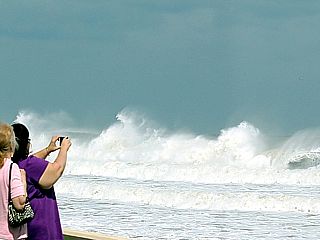
Some people watching the violent surf by the seawall north of the Breakers Hotel in West Palm Beach, Florida late on October 27. |
|
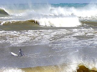
Another picture of the large waves and a surfer south of Boynton Inlet on october 28, 2012. |
|
Large breaking waves, and highly agitated / silty water, near Reef Road / Lake Worth Inlet on October 27, 2012. These waves are over 15 feert high. |
|
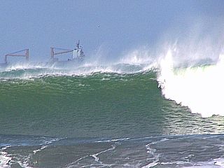
Another closeup of the 8-12 (and higher) foot swells off West Palm beach, Florida on October 28, 2012 as a ship passes offshore. The ship can be seen rolling as well. |
|
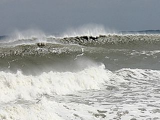
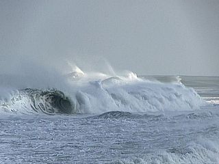
Another view of the huge set waves breaking off Boynton Inlet late in the day on October 28, 2012. The large wave outside is over 15 feet high, and breaking hard (looks more like a big day in Hawaii than Florida). |
|
Looking down the beach (towards the south and southeast) as the violent north and northeast swell off Palm Beach rolls down the beach making for a thrashing scene of whitewater on October 28. |
|
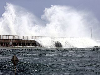
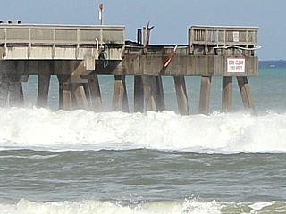
Here is the end of the Deerfield Beach fishing pier on October 27, 2012. Some damage was done to it as 10 to 15 foot waves broke over the end of the pier at times of high tide. |
|
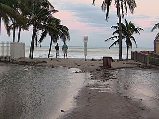
Farther south, and entering the "wave shadow" of the Bahamas offshore as well as an offshore reef causing the swell to remain much farther out before breaking, the waves are much smaller near the shore. However, the water is still piled up by the waves, and caused parts of A1A near Lauderdale By The Sea to become inundated by several feet of storm surge - despite 30 MPH offshore winds. Note the water in the foreground. See those two guys in the picture watching the waves? Look what happened to them a few seconds later (below)! |
|
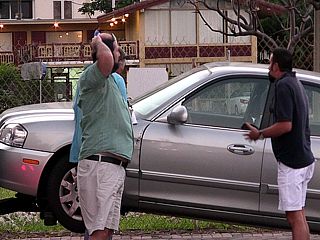
These guys are the same people in the picture above. Taking no more than 30 seconds to check the waves and take a few pictures in Lauderdale By The Sea, it was more than enough time for a tow truck driver to "hook and book" his car, asking for $150 on the spot to put it off the hook. I was happy my car was not towed, thanks to a buddy of mine driving away quickly. |
HTML File "sandy12.htm" - Developed By Chris Collura
To Return To The HOME Page Of This Site Click The "INDEX.HTM" Link Here!