
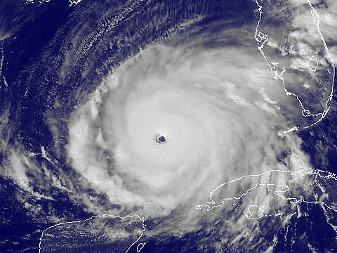
| This area shows pictures taken from the observations and interceptions of hurricane Rita as it brushed the lower Florida Keys. The storm was initially a tropical disturbance that moved off Africa and moved west and northwest until it formed into a tropical depression in the central Bahamas. This depression quickly organized to a tropical storm but was slow at first to gain hurricane status as it exited the Bahamas heading towards the west on September 20. Later that day, the hurricane intensified to a category two storm as it passed just south of Key West, hitting the island with its northern eyewall. The interception of this storm was done in the lower Florida Keys and mainly on the east-facing sides Key West. The storm packed hurricane forced winds, around 80-MPH and a 4 to 7 foot storm surge as it brushed the "lucky" island of Key West as the stronger 100-MPH plus inner eyewall winds were just offshore. Rita was to continue west and continue intensifying while moving steadily towards the west after leaving the vicinity of the Florida Keys and Florida Straits on September 21. In the Gulf of Mexico, the storm explosively intensified to a category five hurricane with 175 MPH sustained winds and a minimum pressure of 897 mb on 9-22-2005! This shattered the pressure and intensity records set by Katrina just 3 weeks prior! The storm then backed off in intensity and came ashore on 9-24 near the Texas and Louisiana border as a 120-MPH major hurricane. Total mileage for this hurricane Rita chase in the Florida Keys was 785 miles. Note - This page may take a while to load on some SLOWER connections! |
| CHASER NAME | HOME CITY | CALLSIGN | OCCUPATION |
| CHRIS COLLURA | MIRAMAR, FL | KG4PJN | COMPUTER ANALYST |
| JEFF GAMMONS | WPB, FL | KG4PGA | PHOTOGRAPHER |
Both STOCK Footage and DVD video of hurricane Rita is available in the SPECIAL OFFERS section of this web site. You can visit that area by clicking either the image above or the link HERE!
|
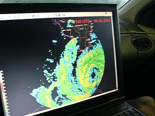
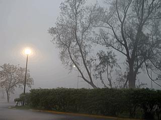
While departing the Holiday Inn in Marathon, Florida on the morning of September 20, 2005, a quick look at the Key West WSR-88D radar (EYW) reveals a developing hurricane approaching our area. Note the nice eye developing. |
|
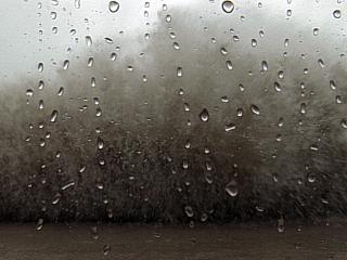
The first heavy rains and bands of thunderstorms with gusty winds arrive well ahead of hurricane Rita. These are the spiral "feeder" bands of the hurricane. |
|
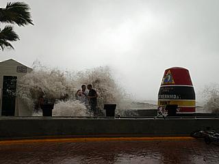
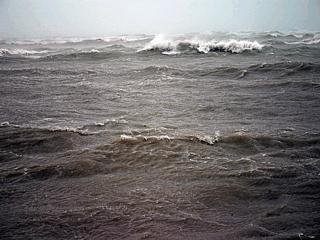
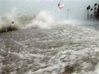
Waves crash against the seawall at the "Southern-most Point in the US" landmark in Key West, FL as rapidly intensifying hurricane Rita passes just to the south of the island. Large swells from the eyewall just offshore reach the normally protected beach / inside reef due to the elevated water level from the storm surge. The teenagers here cannot resist "playing" in the waves but this can be very dangerous. |

|
A strange slot of dry air rotates around the hurricane and causes a banded break in the clouds. The dry air was actually downslope air drawn off the mountains in Cuba that wrapped around the storm. Dry air evaporates clouds. This was only temporary, but made for this interesting banding in this picture, much like a "moat" region between the outer and inner portions of the hurricane. |
|
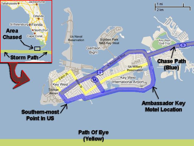
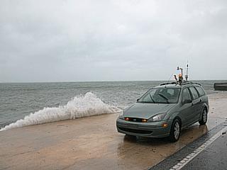
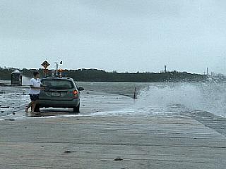
Here is a picture of my chase vehicle with equipment ready for hurricane Rita near the Ambassador Key motel on the southeast side of Key West. We are waiting here because the winds are north and northeast, and offshore. Soon, the northern eyewall will make its closest approach and the winds will shift east and southeast. The onshore flow will then "pile up" water in what is called "wind setup" and cause a storm surge. Tide here are still a few feet above normal, and ground swells are appearing in the normally calm waters. |
|
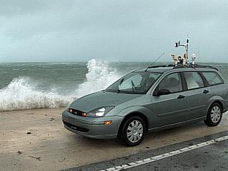
Here is another picture of my chase vehicle with a slightly larger wave breaking over the seawall. Ground swell is increasing slightly more. |
|
Waves and ground swell pick up a bit more, but Rita's stronger winds are still yet to come. In this picture, Jeff Gammons (KG4PGA) standing next to my chase vehicle films the developing ground swell and waves breaking over the seawall. |
|
Here is a picture of myself holding the "Surgecam II" housing my Sony HDR-FX1 HD camcorder. The enclosure is high-visibility orange and clear plastic and allows full high-definition video to be shot in driving winds, rain, and spray. Note the bus stop, as this is a street, and NOT a beach! |
|
Here is a picture of a large wave slamming into the seawall near the Ambassador Key motel and surging into the air. The picture was taken from a frame-grab off video shot with a Sony HDR-FX1 HD camcorder in a waterproof "Surgecam II" housing. |
|
Here is a picture of myself getting the wave shot seen in the previous picture above via the "Surgecam II" enclosure from Jeff Gammon's point of view! |
|
Winds now going northeast to east and increasing. Ground swell and wind driven waves atop a developing storm surge also increasing. The view is to the southeast near the seawall in front of the Ambassador Key motel. |
|
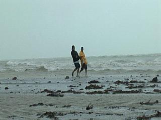
Near the Ambassador Key motel, some young locals walk along the waterfront in increasing easterly winds, now gusting around 45 to 50 MPH. Note the overwash on the roadway now as well as the backward "lean" into the wind of the walking men. |
|
Here is a picture taken from about three stories up on a staircase showing the increasing winds and storm surge as well as the chase vehicle to the far lower left. This is also near the Ambassador Key motel on the northeast side of the island. |
|
Palm trees start responding to the increasing winds as the core of hurricane Rita approaches Key West. |
|
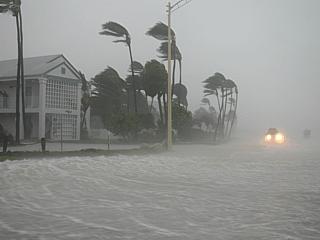
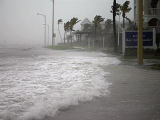
Storm surge rising fast, at least 4 to 7 feet above normal as the eyewall makes its closest approach to Key West. The winds have turned southeast and are now directly on shore. The resultant wind setup causes the surge along Roosevelt Coastal Highway near the Ambassador Key motel. Winds are also hurricane forced now. |
|
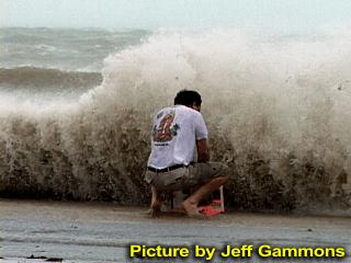
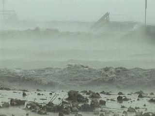
Very strong winds and driving rain affect the southern tip of Key West near the public beach along with battering waves. Note the buckling of the small pier to the right. The water of the hurricane surf is so agitated that it appears like rolling "mud" as silt and sand is also kicked up. This was the northern eyewall clipping the southern tip of the island. |
|
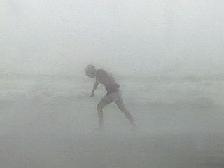
A teenager, who sould not have been out here in the first place, braves near hurricane-forced winds, driving rain, and storm surge wearing a motorcycle helmet. Many young people were out "playing" in the waves and wind, and this is EXTREMELY dangerous if you do not know what you are doing. Note the boy's "lean" in the strong winds. |
|
Strong winds and storm surge smash into and over the seawall and across the roadway near the core of hurricane Rita. |
|
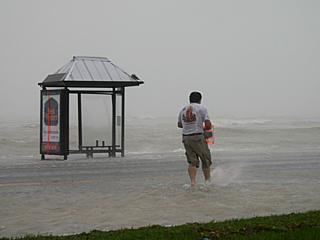
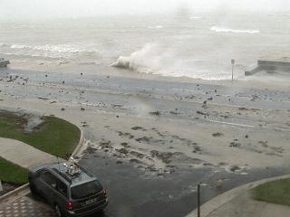
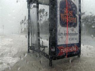
Strong winds and storm surge flood the roadway and damage this bus stop structure during the closest approach of hurricane Rita. |
|
Waves riding on top of the storm surge are now free to move across the road and flood beachfront property on the opposite side of the highway. Storm surge here is 4 to 7 feet above normal in hurricane-forced winds. |
|
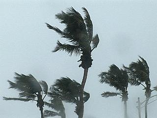
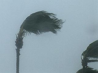
Palm trees thrash in the hurricane-forced winds as hurricane Rita lashes key west with its northern eyewall. |
|
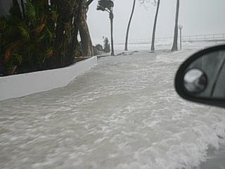
This picture was taken when I was sitting at the parking lot entrance to the Ambassador Key motel. Storm surge has covered the road, and water and waves are rushing into the parking lot and motel. The water came half way up the door on my vehicle! |
HTML File "rit05.htm" - Developed By Chris Collura
To Return To The HOME Page Of This Site Click The "INDEX.HTM" Link Here!