
| This section is for storm chases done in the central / Midwestern United States during the year of 2012. This includes all storm chasing activities (including any major chase "expeditions") during the year of 2012 in the central USA (aka "Tornado Alley"). For 2012, all chases in the central USA will be logged in this section, with many of the chases being possible "spot" chases / major severe weather "setups" chased. Here you should find many pictures of lightning, tornadoes, hail, strong winds, along with many severe thunderstorm elements. Keep in mind that this chase log is scientific evidence and portrays my on-going storm chasing research. It has been placed on this page for easy reference and meteorological interests. Please do not plagiarize or copy this document to other sites for distribution. Note - This page may take a while to load on some SLOWER connections! |
STORM CHASING - CENTRAL UNITED STATES - SPECIAL 2012 CHASE LOG
| CHASER NAME | HOME CITY | CALLSIGN | CHASE DATES | OCCUPATION |
| CHRIS COLLURA | MIAMI, FL | KG4PJN | 4-13 TO 4-15 | IT CONSULTANT |
SEVERE WEATHER STATEMENT
NATIONAL WEATHER SERVICE WICHITA KS
936 PM CDT SAT APR 14 2012
...A TORNADO WARNING REMAINS IN EFFECT FOR NORTHERN SUMNER COUNTY
  UNTIL 1000 PM CDT...
...TORNADO EMERGENCY FOR CONWAY SPRINGS...
  AT 932 PM CDT...A CONFIRMED LARGE...VIOLENT AND EXTREMELY DANGEROUS
  TORNADO WAS LOCATED 5 MILES SOUTHWEST OF CONWAY SPRINGS...AND MOVING
  NORTHEAST AT 35 MPH.
THIS IS A PARTICULARLY DANGEROUS SITUATION.
HAZARD...DEADLY TORNADO.
SOURCE...SPOTTER CONFIRMED TORNADO.
IMPACT...THIS IS A LIFE THREATENING SITUATION. YOU COULD BE KILLED IF
  NOT UNDERGROUND OR IN A TORNADO SHELTER. COMPLETE
  DESTRUCTION OF ENTIRE NEIGHBORHOODS IS LIKELY. MANY WELL
  BUILT HOMES AND BUSINESSES WILL BE COMPLETELY SWEPT FROM
  THEIR FOUNDATIONS. DEBRIS WILL BLOCK MOST ROADWAYS. MASS
  DEVASTATION IS HIGHLY LIKELY MAKING THE AREA UNRECOGNIZABLE
  TO SURVIVORS.
LOCATIONS IMPACTED INCLUDE...
  WELLINGTON...CONWAY SPRINGS...BELLE PLAINE...WELLINGTON AIRPORT AND
  RIVERDALE.
PRECAUTIONARY/PREPAREDNESS ACTIONS...
TO REPEAT...A LARGE...EXTREMELY DANGEROUS AND POTENTIALLY DEADLY
  TORNADO IS ON THE GROUND. TO PROTECT YOUR LIFE...TAKE COVER NOW. MOVE
  TO AN INTERIOR ROOM ON THE LOWEST FLOOR OF A STURDY BUILDING. AVOID
  WINDOWS. IF IN A MOBILE HOME...A VEHICLE OR OUTDOORS...MOVE TO THE
  CLOSEST SUBSTANTIAL SHELTER AND PROTECT YOURSELF FROM FLYING DEBRIS.
TORNADOES ARE DIFFICULT TO SEE AND CONFIRM AT NIGHT. TAKE COVER NOW.
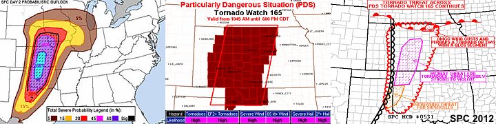
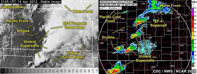
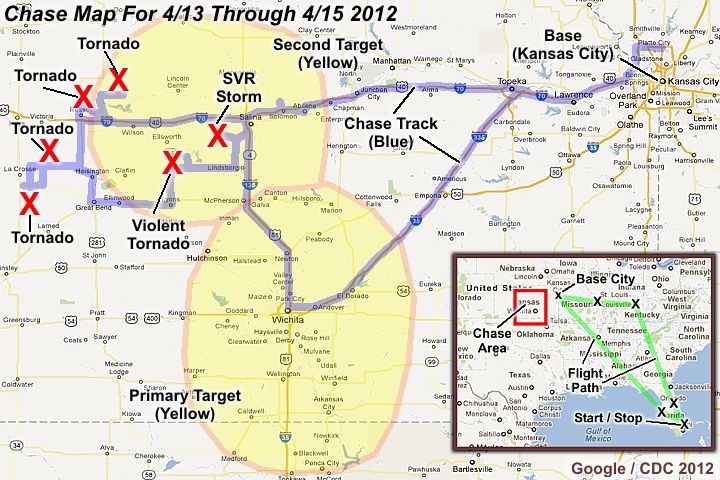
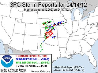
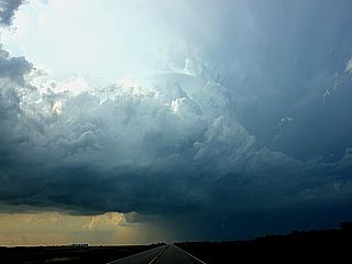
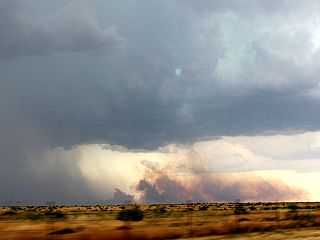
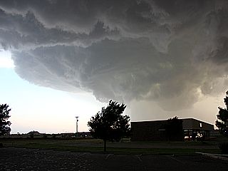
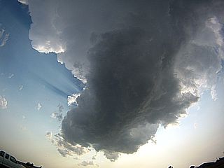
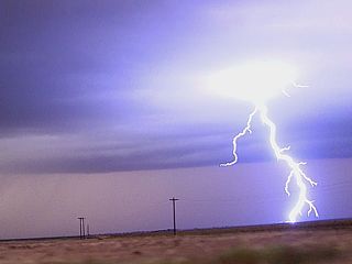
1). April 14, 1:30 PM - Observation and penetration of a very severe and tornadic thunderstorm to the northeast of Russell, Kansas in Russell county from near Highways 281 and Highway 40 and points northeast towards Lucas, Kansas and Luray near Highway 18. The storm was a slightly elevated HP supercell storm, developing near a northward moving warm front that gradually became surface based. This storm also produced the first reported tornado of the day, which I was the first one to observe and report. The tornado developed just northeast of Russell, KS and quickly became rain-wrapped. Id continued northeast and was followed to near Luray then Lucas where it was briefly observed again to the north of a road (Highway 18) blocked by downed powelines. The powerlines were snapped over a wide path (roughly 1/4 mile wide) but the tornado pretty much remained over very open and rural areas. Heading back towards Russell, more tree / powerline damage was observed near 193 / 192 streets, but somewhat narrower, and I had to divert around another blocked road. The storm also contained wind gusts to near 50 MPH, lightning, small hail, and very heavy rains. Conditions causing the storms were a rapidly developing Colorado low pressure area, warm front, surface heating, an intense upper trough, and strong vertical wind shear. A 2012 Chevy Malibu was used to chase the storms. Documentation was HD video and digital stills. A PDS tornado watch was also valid for this area until 6:00 PM CDT.
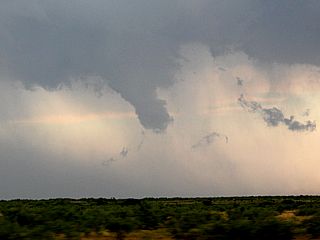
2). April 14, 4:00 PM - Observation and penetration of an extremely severe and tornadic thunderstorm near Rush Center, Kansas in Rush County, Kansas from near Highway 96 Highway 4. The storm was an intense classic supercell storm, and highly cyclic, producing several tornadoes (in which two of the last ones were observed). The core of the storm was not penetrated, and contained hail to baseball sized. The storm had a very striking "stacked plate" visual presentation when viewed from the northeast, with a cone / stovepipe tornado visible under it. This first tornado weakened, and a second one formed near Highway 96 and tracked to the northeast to near Bison, where it dissipated. The second tornado had a beautiful rope structure, and the remnant circulation passed over me on a farm road west of Bison and just south of Highway 4. Other than that, lightning, heavy rains, and winds near 45 MPH were also encountered with this storm. Conditions causing the storms were a Colorado low pressure area, dryline, surface heating, intense upper trough, and strong vertical wind shear. A 2012 Chevy Malibu was used to chase the storms. Documentation was HD video and digital stills. A PDS tornado watch was also valid for this area until 6:00 PM CDT.
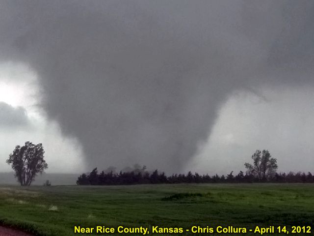
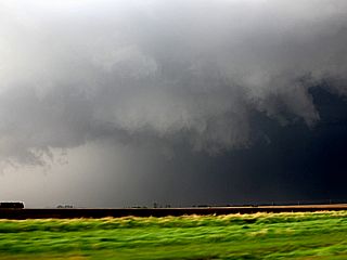
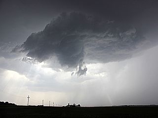
3). April 14, 6:00 PM - Observation and penetration of a extremely severe and violent tornadic thunderstorm from near Lyons in Rice County, Kansas along Highways 56 / 14 and points northeast through Geneseo along Highway 4 and eventually to near the southern side of Salina, Kansas in Saline County near Bridgeport. The storm was a violent classic supercell, and produced the strongest reported tornado of the day, at EF-4 strength, and with winds up to 200 MPH. The storm was first encountered west of Lyons, Kansas and did a split, the core of the storm was indirectly penetrated (between these two splits, which was fortunate, as Highway 56 happened to go through this "soft spot" in the storm). Lightning, violent (horizontal) rains, winds over 70 MPH, and golfball sized hail was found during the penetration to get east of the storm. Once east of the storm, and west of Mitchell, the rain free base of the southern split was noted, developing a pronounced RFD clear slot, and violent tornadogenesis ensued. The tornado began north of Lyons, as a multi-vortex tornado, then matured as a wedge tornado (at least 3/4 mile wide at times), and evolved to a stove pipe, smaller cone, then lifted by about 6:45 PM northwest of Bridgeport. This well documented tornado was on the ground for at least 45 minutes, luckily avoiding any major towns (pavement was reported scoured by this tornado), and damage observed was mainly trees (debarked) and powerlines destroyed. The cyclic supercell storm continued to the NE past Salina, and went on to produce more (but smaller tornadoes). Conditions causing the storms were a Colorado low pressure area, dryline, surface heating, intense upper trough, and strong vertical wind shear. A 2012 Chevy Malibu was used to chase the storms. Documentation was HD video and digital stills. A PDS tornado watch was also valid for this area until 9:00 PM CDT.
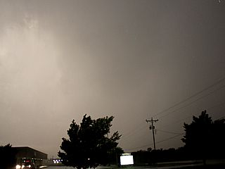
4). April 14, 9:00 PM - Observation and penetration of a very severe and formerly tornadic thunderstorm to the southwest of Salina, Kansas in Saline County just west of Interstate 135 and north of Assaria, Kansas. The storm was a weakening supercell storm, with a history of producing tornadoes earlier. The storm was observed mainly for lightning and hail observation, so the core of the storm was avoided due to the discouraging danger of chasing tornadoes at night. Conditions encountered were continuous lightning, hail and hail fog (marble sized hail covered the ground in one area behind the storm south of Salina); heavy rains, and winds at least 50 MPH. A rotating wall cloud and funnels were also observed with this storm, illuminated by lightning. The storm eventually weakened north of I-70 near Solomon, Kansas. Conditions causing the storms were a Colorado low pressure area, dryline, surface heating, intense upper trough, and strong vertical wind shear. A 2012 Chevy Malibu was used to chase the storms. Documentation was HD video. A PDS tornado watch was also valid for this area until 1:00 AM CDT.
This concludes the Chase Log for the central US Plains and Midwest tornado chase trip from April 13 through April 15, 2012. The summary includes a total of 4 severe thunderstorms and at least 5 separate tornadoes. The main chase vehicle conducting all chases was a 2012 Chevy Malibu. This information was prepared exclusively for the National Weather service and the team of Skywarn storm spotters.
|
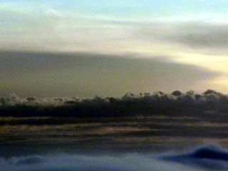
My flight from Florida to Kansas City was severely delayed, and I was bumped off a connection in Orlando, FL ... The flight wound up having 4 (yes Four) stops (Fort Lauderdale, Orlando, Louisville, Saint Louis, then Kansas City) but I was happy to make it. In the picture here, before descending into the St Louis area, a supercell storm can be seen about 200 miles or so to my SW, probably in Oklahoma. After dark during my next and final connection to Kansas City, this same storm was lit by frequent lightning. |

|
Here is a picture of myself and my room at one of the small "mom" and "pop" motels in Wichita, Kansas after arriving late on April 13, 2012. Very cheap and very "old" fashioned. I try to avoid the large hotel chains in small towns, as long as they are clean, have internet, and far more inexpensive for a solo chaser. Also, these family owned places could really use the money us chasers put into them, larger chains could care less. |
|
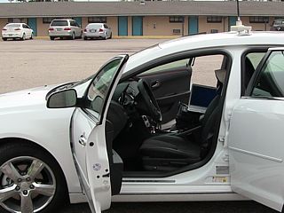
Here's my rental vehicle, a 2012 Chevy Malibu, ready to start the April 14, 2012 chase day from Wichita, Kansas. |
|
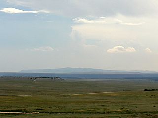
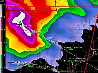
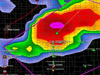
This is a GRLevel3 radar image (base reflectivity) of an HP supercell headed towards Russell, Kansas from the southwest at about 1:15 PM CDT. The white circle to the upper right is my location in Russell at the time. |
|
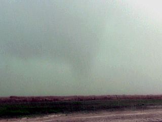
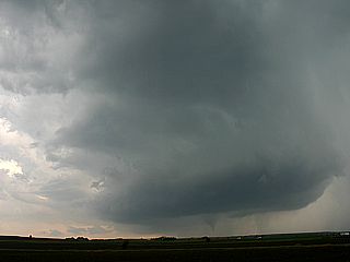
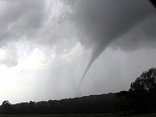
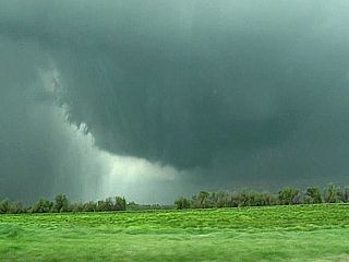
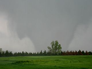
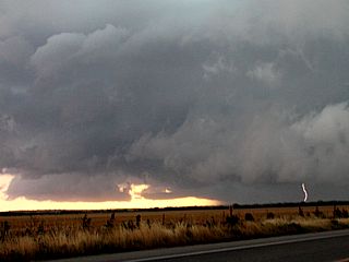
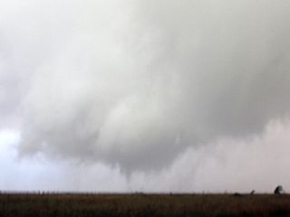
This is a picture of the first tornado of the day, rapidly becoming rain wrapped, from an HP supercell just northeast of Russell, Kansas at about 1:30 PM CDT. |
|
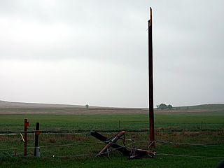
Some power poles were snapped along Highway 18 just west of Lucas, Kansas over a path roughly 1/4 mile wide from the same tornado as it moved northeast out of Russell and over rural farmland. |
|
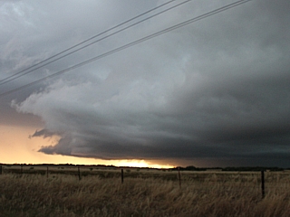
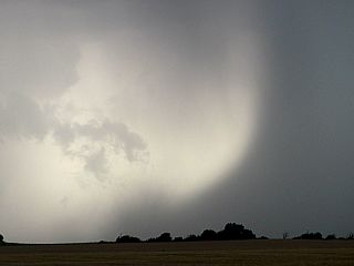
Here is a view looking north from just west of Lucas, Kansas from Highway 14. The RFD temporarily clears out allowing a view of the tornado / funnels to the north. This was the last view of this low-visibility tornado. |
|
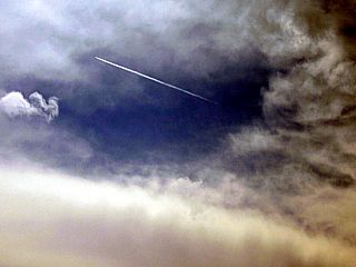
While heading south and then west towards an intense supercell near Rush Center, Kansas ... A jet airplane flying at high altitude makes its way through the space between the Rush County supercell and another developing to the southeast (the latter to become a violent tornado-producer in Rice County). This is one of many contrails seen passing through this "space", before it closed up. |
|
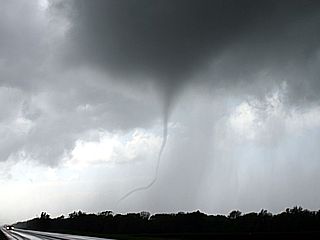
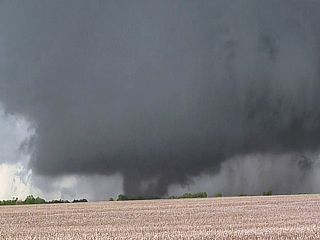
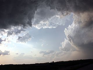
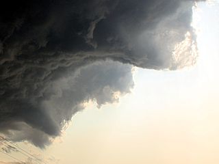
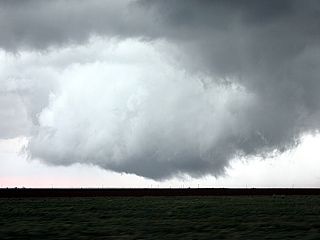
This is the Rush County supercell with a stove-pipe tornado under it viewed from about 4 miles to the northeast of the storm. Note the beautiful storm structure. Time is roughly 4 PM CDT. |
|
Here is a close-up shot of the same tornado from the Rush County storm. |
|
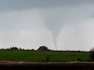
The rush county storm weakend but cycled up again one last time (before a new supercell storm developed to its southeast, cutting off its inflow) and went on to produce this thin rope tornado near Rusn Center, Kansas at about 4:15 PM CDT. |
|
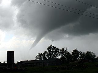
As this tornado move to the northeast, it took on a beautiful elephant-trunk type structure. Note the highly-sheared nature of the tornado, with the upper portion of it much wider but being pulled rapidly northeast. The view is to the northwest from a farm road between Rush Center and Bison, Kansas. |
|
Another view of the same elephant trunk / rope tornado just as it was southeast of Bison, Kansas and before lifting and dissipation by about 4:30 PM CDT. |
|
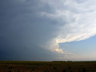
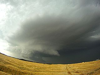
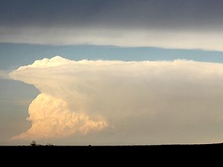
Intense supercell storm that developed to the southeast (view is SSE) near Rice County, Kansas at about 4:45 PM. This storm will move northeast and spawn the strongest tornado of the day in the entire high-risk area. |
|
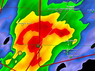
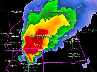
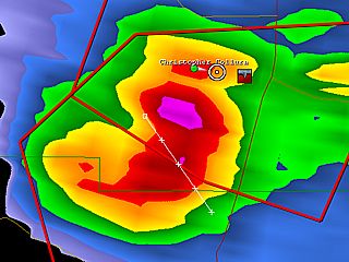
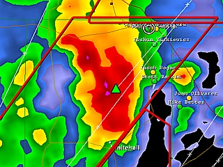
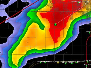
Here is a GRLevel3 radar image (base reflectivity) of the intensifying supercell in Rice County, Kansas at about 5:30 PM CDT just after passing through a "soft" area in the storm core. My location is just right of the center of the image (white circle). Note the hook developing to the southern end of the storm (and "flying eagle" radar presentation). |
|
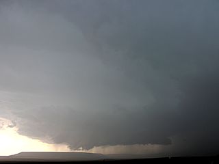
This is a view of the rain-free base of the Rice County supercell near Lyons, Kansas during a fuel stop at about 5:45 CDT. The view is to the south. Note the RFD punch coming in from right-to-left south of the dark cloud base in the foreground. |
|
As this rapidly intensifying storm moved to the north of Lyons, Kansas, an intense RFD (and clear slot) developed in the elongated supercell storm. The view is to the northwest. Shortly afterwards, the storm rapidly developed (cyclic supercell) and went on to produce a long-track and violent EF-4 tornado. |
|
Multivortex stage of the developing violent tornado north of Lyons, Kansas at roughly 6 PM CDT. The view is to the northwest. |
|
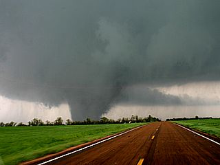
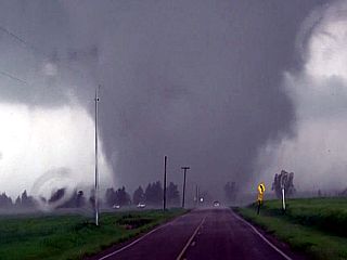
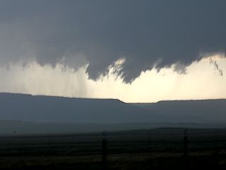
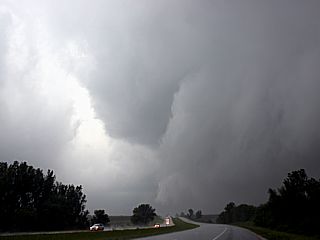
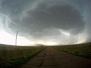
Nearly mature wedge tornado in Rice County, Kansas and about 30 seconds before crossing Highway 14 (view is to the north). Note the inflow bands to the northeast of the tornado! |
|
Wedge tornado (nearly 3/4 mile wide) at about 6:15 PM and intensifying to EF-4 strength (winds up to 200 MPH). Note the horizontal "satellite" vortex just to the right of the main circulation (view is to the northwest). The motion on this visually was very fast, and the "scary" structure (and beauty) of this violent tornado was very reminescent of the Tuscaloosa Alabama footage from nearly a year prior! |
|
Violent tornado now crossing the roadway again near Geneseo, Kansas. The road bends to the northwest (view is to the north), but I am opting to take a farm road straight ahead. North of here is where pavement was scoured and trees debarked. It was VERY fortunate this EF-4 tornado remained over sparsely populated / rural farm land. Note the powerful inflow jet to the lower left! |
|
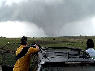
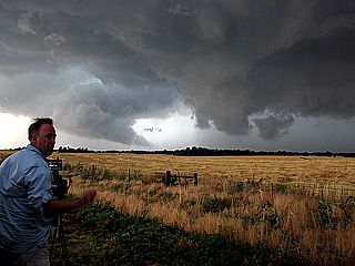
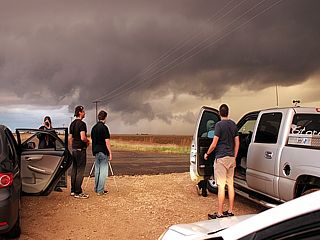
Downed trees blocked this durt farm road, causing us to have to back track, but not before enjoying the rare view of a violent tornado in the field in front of us! In this picture, chaser Verne Carlson and others indulge and film the violent drama just to our northeast. |
|
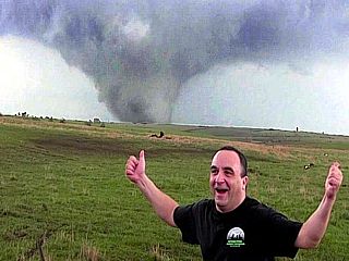
Here is a self-portrait shot of myself in jubilation as the violent tornado churns in a field behind me. |
|
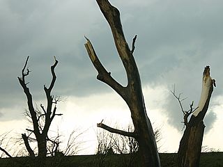
Downed trees blocking this farm road near Geneseo, Kansas were stripped of branches and bebarked by the southern side of the wedge tornado. |
|
Tornado now moving northeast of Geneseo, Kansas and north of Crawford by about 6:30 PM CDT. The widest point of this tornado was from 3/4 of a mile to almost a mile-wide. The view here is to the north from near Highway 4. |
|
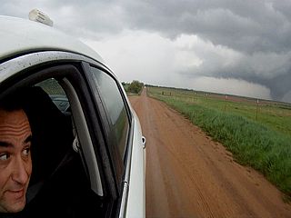
Interesting GoPro camera shot of myself driving and looking back at the tornado as it continued moving north of my location on a farm road near Marquette, Kansas. |
|
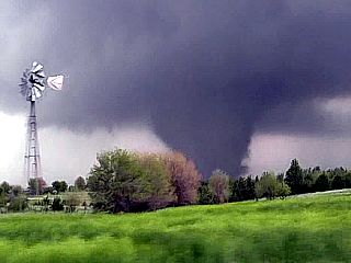
View of a farmstead, windmill, and some trees with the tornado to the north - Classic! |
|
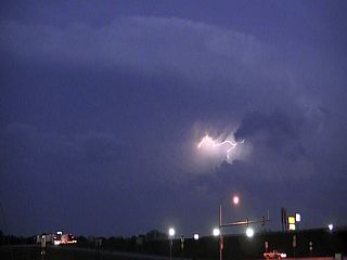
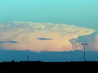
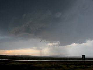
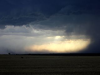
Here is a view of another tornadic supercell, about 50 miles to the southeast of Salina, Kansas, with frequent lightning during the twilight (about 8 PM CDT) of April 14. |
|
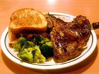
After a great day of tornadoes and a highly successful chase day, a nice hot meal with broccholi, Texas toast, and a 16 Oz juicy steak is to be had to wrap it all up! |
|
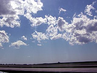
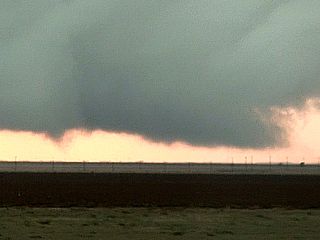
Here is a view of the dryline / cool front pushing into the Kansas City area near the airport on April 15, 2012. The line of agitated cumulus in the foreground is contrasted to a cloud-free sky to the west behind the dryline. |

|
As with every major severe weather event - One must realize that these storms can and do kill. Fortunate for many people on April 14 who managed to be spared by nature's wrath ... But unfortunate for those in the small town of Woodward, Oklahoma. A tornado there killed at least 5 people during the early night of April 14. The grim aftermath is shown here airing on a TV (CNN) at Kansas City International Airport. |
|
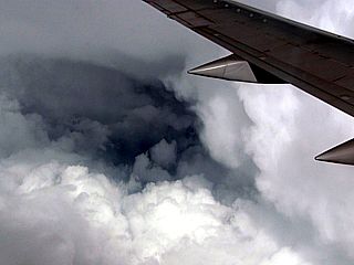
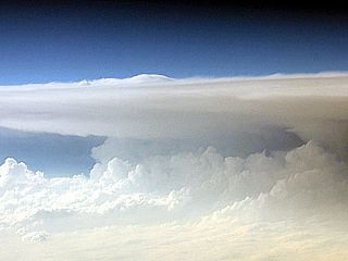
Here is a view out my window during heavy turbulence at roughly 37,000 feet over Missouri / Arkansas on April 15, 2012 en-route to Tampa, FL from Kansas City. We basically had to find a "soft spot" in a nearly solid line of severe thunderstorms and supercells to fly through. The view here shows the back-sheared anvil "overhang" just to our east and dark area looking down into the storm. |
| CHASER NAME | HOME CITY | CALLSIGN | CHASE DATES | OCCUPATION |
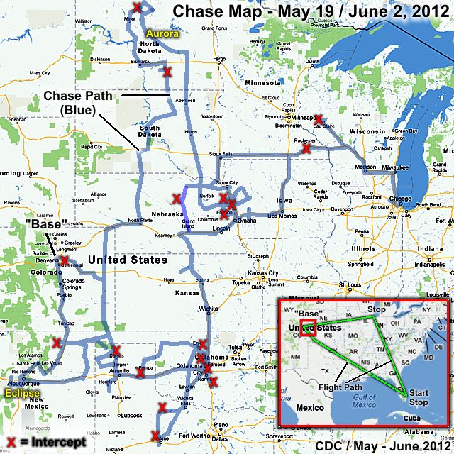
| CHRIS COLLURA | MIAMI, FL | KG4PJN | 5-19 TO 6-2 | IT CONSULTANT |
The participants below are others who joined in or caravaned with me as I was chasing. These people often actively participate in our storm research efforts and deserve appreciation for their great help and severe weather expertise.
| AMOS MAGLIOCCO | DENTON, TX | KC5VPD | WRITER |
| IAN LIVINGSTON | BALTIMORE, MD | N/A | STUDENT |
| JASON FOSTER | BALTIMORE, MD | N3PRZ | ARCHITECT |
| MARK ELLINWOOD | BALTIMORE, MD | N/A | STUDENT |
| TONY LAUBACH | LITTLETON, CO | KC0ONL | METEOROLOGIST |
1). May 21, 6:30 PM - Interception and penetration of a very severe thunderstorm to the west and southwest of Springer, New Mexico and near the intersections of Interstate 25 and highway 56 in Colfax County. The storm was a supercell storm (ranging from classic to high-precipitation modes during its lifetime). A large rotating wall cloud was observed on the southern side of the supercell storm, and several funnels were observed. The storm core was indirectly penetrated, and conditions encountered there were very heavy rains, frequent lightning, winds gusting near 50 MPH, and hail up to the size of quarters (with smaller pieces noted covering the ground). Conditions causing the storms were surface heating, a low pressure trough, upper trough, boundary interactions, and up-slope wind flow. A 2012 Kia Forte was used to chase the storms. Documentation was HD video and digital stills. A severe thunderstorm watch was also valid for this area until 10:00 PM MDT.
2). May 22, 8:30 PM - Interception and penetration of a very severe and possibly tornadic thunderstorm to the north of Minot, North Dakota near Maxbass and east of Highway 83 in Bottineau County. The storm was an intense classic to HP supercell storm. The core of the storm was indirectly penetrated (on the southern side) and inflow / RFD winds over 60 MPH was observed. Heavy rains, small hail, and occasional lightning were also observed, along with a rotating wall cloud / funnels. A possible brief tornado (bad contrast / rain wrapped from my view) may also have developed when the storm was near Maxbass, ND. The main storm core, containing very large hail, was not penetrated. The supercell storm also had a striking visual appearance (striations and RFD clear-slot). Conditions causing the storms were surface heating, a low pressure area, strong upper trough, and warm front. A 2012 Kia Forte was used to chase the storms. Documentation was HD video and digital stills. A tornado watch box was also valid for this area until 11:00 PM CDT.
3). May 23, 5:30 PM - Observation of a very severe thunderstorm near North Bend, Nebraska in Dodge County near Highway 30 and State road 79. The storm was observed from initiation west of Schulyer, NE and followed as far as Nickerson (before it moved NE becoming an HP supercell / line segment into Iowa). The storm began as a classic supercell, with a rotating wall cloud for some time. The core of the storm was not penetrated (contained hail to golfball sized). Some gustnadoes were also observed with this storm, and winds gusting near 50 MPH were encountered with the RFD area. Conditions causing the storms were surface heating, a low pressure trough, upper trough, and a cold front. A 2012 Kia Forte was used to chase the storms. Documentation was HD video and digital stills. A severe thunderstorm watch was also valid for this area until 11:00 PM CDT.
4). May 23, 7:30 PM - Observation and indirect penetration of a severe thunderstorm north of Blair, Nebraska in Washington County near Highway 75. The storm was a supercell storm that evolved to an intense line segment. Conditions encountered with the storm were winds gusting near 45 MPH, heavy rains, frequent lightning (with some close hits), and small hail as the more intense hail core passed just to my north. Conditions causing the storms were surface heating, a low pressure trough, upper trough, and a cold front. A 2012 Kia Forte was used to chase the storms. Documentation was HD video and digital stills. A severe thunderstorm watch was also valid for this area until 11:00 PM CDT.
5). May 23, 8:00 PM - Observation and indirect penetration of a severe thunderstorm north of Bennigton, Nebraska in Washington and Douglas Counties near State Road 133. The storm was an HP supercell storm, and a rotating wall cloud was observed with it for about 5 minutes before being under-cut. The core of the storm was allowed to pass by my north, which visually had a bright green appearance, and contained hail to golfball sized. Some large pieces of hail were also seen on the ground. Frequent lightning, heavy rains, small hail, and winds to hear 45 MPH were also encountered. Conditions causing the storms were surface heating, a low pressure trough, upper trough, and a cold front. A 2012 Kia Forte was used to chase the storms. Documentation was HD video and digital stills. A severe thunderstorm watch was also valid for this area until 11:00 PM CDT.
6). May 24, 6:00 PM - Observation and penetration of severe thunderstorms from near Eau Claire, Wisconsin in Eau Claire County and near Interstate 94 and Highway 12 southeastward through Osseo in Trempealeau County and farther to near Black River Falls in Jackson County. The storm was a multicell line of severe storms, and a few intense cells were penetrated in this area. The most severe cells had winds near 70 MPH, extremely heavy rains, pea to dime sized hail, and frequent lightning (with some close hits). Some wind damage was done by the storm near Eau Claire. Conditions causing the storms were surface heating, a low pressure area, upper trough, and a cold front. A 2012 Kia Forte was used to chase the storms. Documentation was HD video and digital stills. A tornado watch was also valid for this area until 10:00 PM CDT.
7). May 26, 12:00 PM - Indirect penetration of a severe thunderstorm southwest of Rochester, Minnesota along Interstate 90 in Olmsted county. The storm was an elevated severe storm developing north of a warm front, and contained high winds and large hail. I passed just south of the multicell severe storm, and found 50-60 MPH wind gusts, small hail, heavy rains, and frequent lightning. Conditions causing the storms were a low pressure trough, upper trough, and a warm front. A 2012 Kia Forte was used to chase the storms. Documentation were digital stills.
8). May 26, 7:00 PM - Interception and observation a severe thunderstorm east of O'Neill, Nebraska near Knox and Holt Counties and north of Highway 20. The storm was a high-based LP supercell storm. The storm produced lightning, moderate rain, and winds gusting over 50 MPH. The hail core was not penetrated. Conditions causing the storms were surface heating, a low pressure area, upper trough, and a warm front. A 2012 Kia Forte was used to chase the storms. Documentation was HD video and digital stills. A severe thunderstorm watch was also valid for this area until 10:00 PM CDT.
9). May 27, 7:30 PM - Interception and observation a severe thunderstorm east of Phillipsburg, Kansas along Highway 36 in Phillips County, Kansas. The storm was an HP supercell storm, developing ahead of a line of severe thunderstorms. This storm contained hail up to 2 inches in diameter and winds over 60 MPH with heavy rains, but the storm core was not penetrated. A rotating wall cloud and small funnel was also observed on the SE side of the storm with striations visible in the storm updraft. Conditions causing the storms were surface heating, a low pressure area, upper trough, and a dryline. A 2012 Kia Forte was used to chase the storms. Documentation was HD video and digital stills. A severe thunderstorm watch was also valid for this area until 12:00 AM CDT.
10). May 28, 5:00 PM - Observation and indirect penetration of a very severe thunderstorm southeast of Vernon, Texas along Highway 287 then southward along Highway 183 in Wilbarger County. The storm was a supercell storm, and the northern edge of its intense hail core was penetrated. Conditions encountered were hail up to 1.25", lightning, heavy rains, and winds gusting over 60 MPH, raising dust. The main core had hail over 2" reported. A wall cloud and funnel cloud also was noted when west of this storm, along with a lot of smoke from a brush fire started by lightning. Conditions causing the storms were surface heating, a low pressure area, upper trough, and a stalled frontal boundary. A 2012 Kia Forte was used to chase the storms. Documentation was HD video and digital stills. A severe thunderstorm watch was also valid for this area until 12:00 AM CDT.
11). May 28, 8:00 PM - Interception and indirect penetration of an extremely severe thunderstorm from near Mabelle, through Seymour along Highways 82 and 183 and to near Olney and finally near and south of Elbert and in Baylor and Throckmorton Counties, Texas. The storm had an extremely dangerous hail core (80+ DBz on reflectivity) when it was northwest of Seymour, Texas. Of course, the core was not penetrated. A wall cloud was noted on the storm before it merged with a line segment. During the indirect penetration of the storm south of Elbert, 70 MPH winds, torrential rains, hail to 1", and frequent lightning with close hits was observed. A very "green sky" affect was also produced by this storm. Trees were down and power knocked out in some towns. Conditions causing the storms were surface heating, a low pressure area, upper trough, and a stalled frontal boundary. A 2012 Kia Forte was used to chase the storms. Documentation was HD video and digital stills. A severe thunderstorm watch was also valid for this area until 12:00 AM CDT.
12). May 29, 5:00 PM - Interception and indirect penetration of a very severe thunderstorm near Nash, Oklahoma along Highway 64 in Grant County. The storm was an HP supercell storm, containing hail up to 2.5". The storm was the northern-most cell in a cluster of three significant supercell storms. Some hail to 1" was observed trying to get ahead of the storm. A small RFD feature and clear slot was also noted with this storm. The storm also contained heavy rains, frequent lightning with some close hits, and winds near 50 MPH. Conditions causing the storms were surface heating, a low pressure area, upper trough, dryline, and a stalled frontal boundary. A 2012 Kia Forte was used to chase the storms. Documentation was HD video and digital stills. A severe thunderstorm watch was also valid for this area until 11:00 PM CDT.
13). May 29, 7:00 PM - Interception and indirect penetration of an extremely severe and tornadic thunderstorm near Drummond and then into Hennessey, Oklahoma from along Highways 132 and 51 in Kingfisher County. The storm was a classic (eventually evolving to HP) supercell storm, and contained hail up to baseball sized. The storm was the middle cell in a cluster of three significant supercell storms. Some hail to 1.5" was observed trying to get to the southern side of the storm. The storm had a large rotating wall cloud, then produced a brief and weak (but large) tornado with a well organized RFD. Winds to 60 MPH, frequent lightning, and heavy rains were also encountered. Conditions causing the storms were surface heating, a low pressure area, upper trough, dryline, and a stalled frontal boundary. A 2012 Kia Forte was used to chase the storms. Documentation was HD video and digital stills. A severe thunderstorm watch was also valid for this area until 11:00 PM CDT.
14). May 29, 8:30 PM - Interception and direct penetration of an extremely severe and tornadic thunderstorm near Piedmont, Oklahoma north of Highway 3 in Canadian County. The storm was another classic / HP supercell storm. The storm produced extremely large hail, in the 3 to 5 inch range! Some of this hail was observed just NE of Piedmont, OK. The storm also produced a rain-wrapped tornado, which was visible from my vantage point with baseball to grapefruit sized hail (and larger) falling. Winds near 60 MPH, heavy rains, and frequent lightning as also observed with this supercell storm. One 3.5" hailstone struck the chase vehicle just above the windshield (sparing the windshield) and leaving a large dent and even breaking the inside dome light (before moving the vehicle against a restaurant wall)! The tornado caused some sporadic damage (outside of power being knocked out) in Piedmont but fortunately missed any majorly populated areas. An low audible "roar" was also noted during the tornado. Conditions causing the storms were surface heating, a low pressure area, upper trough, dryline, and a stalled frontal boundary. A 2012 Kia Forte was used to chase the storms. Documentation was HD video, audio, and digital stills. A severe thunderstorm watch was also valid for this area until 11:00 PM CDT.
15). May 29, 10:00 PM - Interception and penetration of a very severe thunderstorm near Moore, Oklahoma along Interstate 40 in Cleveland County. The storm was an multicell cluster of severe thunderstorms. While pulled over on I-35, the store core passed with frequent lightning (with some close hits), torrential / violent rain, hail to 1", and winds gusting near 80 MPH. This storm also evolved into a bow structure on radar. The storm caused tree and sign damage, as well as knocking out power. Much more extensive damage near Piedmont was done from the hail, with some stones reported to be five, or even SIX inches across! Conditions causing the storms were surface heating, a low pressure area, upper trough, dryline, and a stalled frontal boundary. A 2012 Kia Forte was used to chase the storms. Documentation was HD video and digital stills. A severe thunderstorm watch was also valid for this area until 11:00 PM CDT.
16). May 30, 6:30 PM - Interception and observation of a severe thunderstorm near Mclean in Gray County, Texas north of Interstate 40 and near State Road 273. The storm was an LP supercell thunderstorm, and on the northern end of a broken line of supercells (the southern most being the most intense). The storm had a striking visual appearance (cork-screwed updraft and RFD with some small funnels) but was rather high based. The core was not penetrated, but contained golf ball sized hail. Some hail to 1/2" was observed as the storm was weakening near Mclean. Conditions causing the storms were surface heating, a low pressure area, upper trough, and dryline. A 2012 Kia Forte was used to chase the storms. Documentation was HD video and digital stills. A tornado watch was also valid for this area until 9:00 PM CDT.
17). June 1, 6:00 PM - Interception and indirect penetration of a severe thunderstorm from near Dalhart, Texas and Highways 287 and 54 in Dallam County and points southward through Hartley and Oldham counties to near I-40 and Highway 385. The storm was a supercell thunderstorm. The core was not penetrated during its most intense phase when it was west of Channing, Texas. The storm produced hail up to 3". Largest hail observed was about 1", with 60 MPH winds, frequent lightning (with some close hits), and very heavy rains. A wall cloud and small funnel was also noted on the storm when it was northwest of Channing. Conditions causing the storms were surface heating, a low pressure area, upper trough, and boundary / stalled front interactions. A 2012 Kia Forte was used to chase the storms. Documentation was HD video, audio, and digital stills. A severe thunderstorm watch was also valid for this area until 10:00 PM CDT.
18). June 2, 2:30 PM - Observation of a severe thunderstorm near Denver International Airport north of Aurora in Denver County, Colorado near Pena Boulevard. The storm was an outflow-dominant severe storm (line segment) which produced winds from 60 to as high as 80 MPH. The storm was observed just before leaving the car at the rental return at a gas station. Winds observed were at least 60 to 70 MPH, with some sign / tree debris airborne, and a lot of dust. Conditions causing the storms were surface heating, a low pressure trough, and upslope wind flow. A 2012 Kia Forte was used to observe the storms. Documentation was HD video and digital stills. A severe thunderstorm watch was also valid just east of this area until 10:00 PM MDT.
This concludes the Chase Log for the central US Plains and Midwest tornado chase trip from May 19 through June 2, 2012. The summary includes a total of 18 severe thunderstorms and 3 tornadoes (two of which was confirmed). The main chase vehicle conducting all chases and observations was a 2012 Kia Forte. This information was prepared exclusively for the National Weather service and the team of Skywarn storm spotters.
|
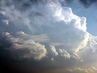
Unfortunate not to be able to chase in Kansas this day, but fortunate enough to get a view of one of the tornadic supercells while the pilot was struggling to find a "soft spot" through the convection and heavy turbulence over Kansas and Nebraska (flying into Denver from Chicago). Here is a pretty view of one of the tornadic supercells from about 38,000 feet. |
|
Here is a picture of a distant supercell storm (looking southeast from near Denver International airport) late on May 19, 2012. I really wish I arrived a day earlier, but at least I got to see something flying in. |
|
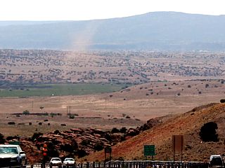
While en-route from Denver, CO to Albaquerque, NM along I-25, thus beautiful dust devil was spotted in the valley between Santa Fe and Albaquerque. |
|
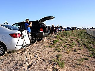
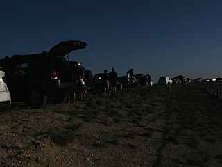
Here is a view of a crowd of eclipse watchers lining the roadside (Paseo del Volcan) near the Double Eagle airfield west of Albaquerque, New Mexico at about 6:30 PM MDT. Compare this picture, just before the eclipse began, to the one below in totality. Eclipse "chasers" are called "umbraphiles" (shadow liking). |
|
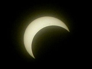
Here is a view, through a special dark filter (similar to welding glasses) of the eclipse at roughly 7:15 PM MDT. The eclipse is more than 50% underway. Note the sunspot as well! |
|
Eclipse nearing totality viewed through a dark filter. This was at about 7:20 MDT. |

|
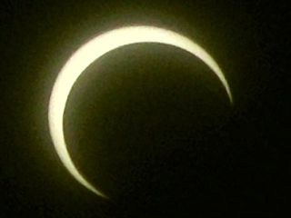
Brighter view of the total annular eclipse (at roughly 7:30 MDT) using a ND filter. The "David's star" pattern is a lens artifact / flare. This stage of the annular eclipse is called the "ring of fire". |
|
Same view of crowd of eclipse watchers as the first shot above, but in highly dimmed sunlight of the total annular eclipse. |
|
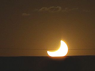
This is how the sun set on May 20 west of Albaquereque, NM. Basically it was a "half of a sun" setting. |
|
While heading west on Highway 56, some convection (supercell storms developing in up-slope wind flow) can be seen looming over the New Mexico landscape. |
|
Approaching the supercell storm in Colfax County and to the southwest of Springer, NM and west of Interstate 25. |
|
Large rotating wall cloud to the southwest of Springer, NM and west of Interstate 25. |
|
Some funnel clouds on the rotating wall cloud to the southwest of Springer, NM. |
|
Radar image (reflectivity) of the storm (Gibson Ridge Level 3 with annotated overlays) showing my position (white marker) and the storm core about the time the pictures of the wall cloud / funnels above were taken. |
|
Interesting view looking to the southeast at the rear-flank downdraft (from right to left), rotating wall cloud (upper portion of picture), and leading edge of the precipitation "hook" of the supercell (center). This is the "bear's cage" of the supercell storm, where a tornado is possible. This was south of Springer, NM along I-25. |
|
Here is a view of a distant supercell (over 80 miles away near Johnson, Kansas) in the setting sun as viewed from near Boise City, oklahoma. |
|
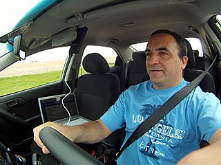
Here is a picture of myself in the Kia Forte chase vehicle during the very long drive from North Platte, Nebraska to northern North Dakota. |
|
Supercell storm developing about 20 miles north of Minot, ND (along Highway 83) by about 8 PM CDT (the sun sets very late this far north)! |
|
The storm produced a rotating wall cloud with some funnels as you can see in this picture. This was near Maxbass, ND. |
|
Very large RFD clear slot associated with the intense supercell storm near Maxbass, ND. The view is to the NW. |
|
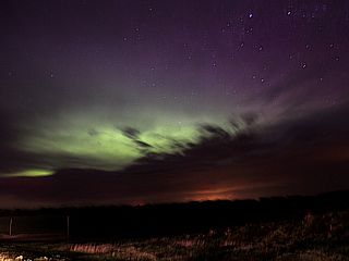
Here is a picture (time exposure) of the northern lights from near Fessenden, ND. The view is to the northeast throught broken clouds. This was my first time ever seeing the Aurora Borealis. |
|
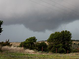
Rotating wall cloud associated with a supercell north of North Bend, Nebraska. |
|
Gustnado on the RFD gust front of the supercell near North Bend, Nebraska. |
|
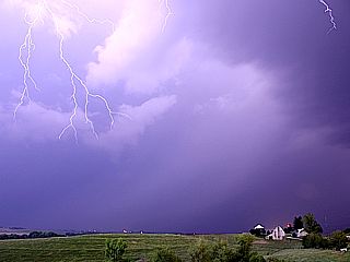
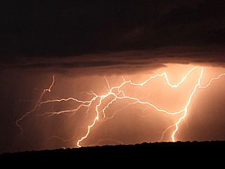
Close hit was behind me, illuminating the landscape, with some branching of lightning in the upper part of the photo (near Avoca, Iowa). |
|
This is a radar image (base reflectivity) of one of the intense severe cells in the line of thunderstorms in SW Wisconsin near Osseso (using Gibson Ridge Level III). |
|
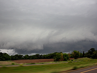
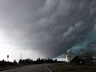
Here is a picture of the gust front and shelf cloud associated with the cluster / line of severe thunderstorms as it was between Osseso and Eau Claire (damage was done by this storm, with trees downed and a greenhouse destroyed in the area). The storm packed 50-70 MPH winds. |
|
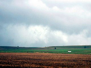
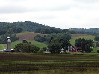
This is where I was STUCK while one of the would-have-been best days of my chase trip was un-folding back in Kansas. At least the landscape there is pretty. |
|
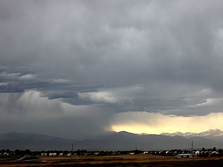
This is a severe storm (gust front and inflow region) associated with elevated severe storms southwest of Rochester, Minnesota during noontime along Interstate 90. |
|
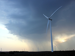
Here is a picture of an LP supercell that developed to the east of O'Neill, Nebraska with a wind turbine in the foreground. |
|
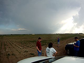
Here is a wide shot of a small chaser group (Tony Laubach, Amos Maggliocco, Jason Foster, Mark Ellingswood, and Ian Livingston) near the KS / NE border waiting for storms to organize as a supercell storm looms over the horizon to the southwest. |
|
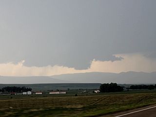
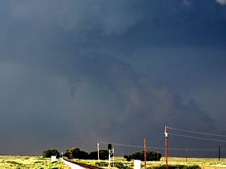
HP supercell storm near Phillipsburg, Kansas with an interesting lowering. This was a rotating wall cloud and brief (small) funnel. |
|
Here is a picture of a small mid-level funnel that formed on the western side of one of the LP supercell storms northwest of Minneapolis, Kansas |
|
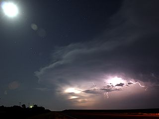
Interesting time-exposure of lignting illuminated LP supercell storm as the moon shines overhead northwest of Salina, Kansas. |
|
A lightning strike starts a fire near a supercell to the east of Highway 183 and well southeast of Vernon, Texas. Note the strong RFD blowing the smoke and it rising to cloud base. |
|
A brief funnel develops on the inflow side, north of the smoke plume, from the supercell to the east of Highway 183. |
|
Here is a reflectivity radar image of the supercell storm just northwest of Seymour, Texas. With 80 DBz, I think I would keep my rental vehicle out of there! |
|
Meanwhile, the view of the same storm northwest of Seymour, Texas looked like this (view is to the WNW). The RFD / outflow can easily be seen kicking up dust. |
|
Same supercell storm now merging with the southern end of an intense line segment northwest of Throckmorton and near Elbert, Texas. |
|
Same supercell storm making the upscale transition into a multicell severe MCS (last true mesocyclone) south of Elbert. |
|
Some reddish colored lightning with a storm well to the west from near Elbert, Texas. But WHY is the lightning "red' colored? This is because the elevated storm producing the lightning is nearly 100 miles away, and the shot is a cropped tight shot of the storm, where the long distance of the light traveling through dust in the air tints the color of the bolt from blue-white to yellowish. |
|
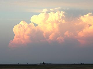
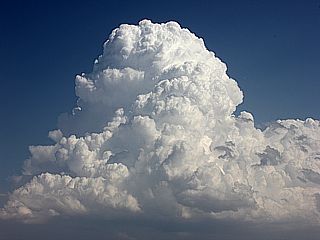
Convective initiation to the southeast of Alva, Oklahoma starts a great chase day of supercells. This developing supercell storm, in its cumulus stage, could be seen billowing upward into the sky. |
|
Impressive rain "foot" associated with the downdrafts in the hail / rain core of a supercell near Nash, Oklahoma. Extreme wind (wet microburst) is denoted by the "curling" of the edge of the rain foot. |
|
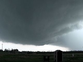
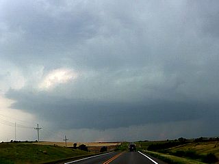
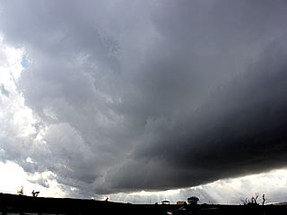
Here is a picture (wide-angle) view of a developing tornadic supercell storm near Hennessey, Oklahoma with a large rotating wall cloud. |
|
Jeff Pitrowski and his wife were also watching the storm from the side of the highway (state road 51 near Hennessey) as it produces a brief tornado. |
|
Very large hail (called "gorilla" hail) falling near Piedmont, Oklahoma from another violent supercell storm. |
|
Here is a view of the developing tornado near Piedmont from the Piedmont supercell as it was dropping hail up to 5" in diameter (and larger)! |

|
Here is an interesting hailstone I picked up near the Piedmont, OK supercell. This stone is about 3", and was actually one of the SMALLER stones! |
|
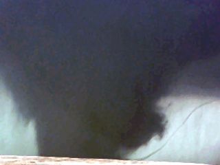
Low contrast view (rain wrapped) of the Piedmont tornado. From this vantage point, a low-pitched roar could be heard. |
|
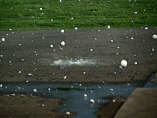
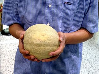
With reports of hail in Piedmont approaching SIX inches ... This melon dictates how big of a hailstone that would be! |
|
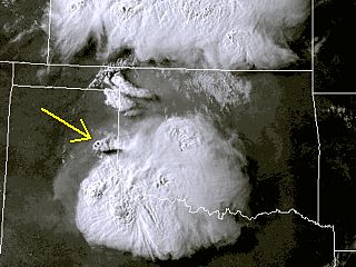
Satellite (visible) image at roughly 6:30 PM CDT. The arrow shows the LP supercell storm and my approximate location (150 miles TOO far to the NW of where I should have been). |
|
Low precipitation (LP) supercell storm northwest of Mclean, Texas. |
|
Closer view of the RFD region of the high based LP storm near Mclean. |
|
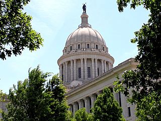
Today was an off day spent in Oklahoma City. In this picture, the 1919 structure of the OK State Capitol senate building can be seen through the trees. |
|
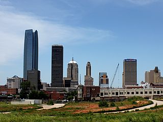
Downtown Oklahoma City viewed from the ESE with the new Devon Energy building to the left. |
|
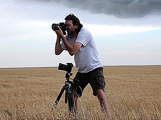
Here is Jason Foster (N3PRZ) shooting pictures of a developing supercell storm near Stratford, Texas. |
|
Wide angle shot of a supercell storm west of Channing, Texas. Note the RFD cut and dust being kicked up underneath. |
|
Small funnel end wall cloud developing off a supercell storm near Dalhart, Texas. |
|
Distant supercell storm looking to the northeast neatr Channing, Texas. The storm was about 75 miles away over the OK / KS border. |
|
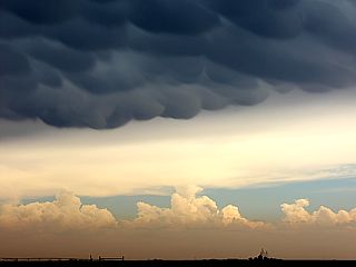
Beautiful mammatus clouds over Dalhart, Texas. |
|
High based supercell storm during the early afternoon to the south of Denver, CO as I was on my way to the airport to return the rental vehicle and leave back to Florida. |
|
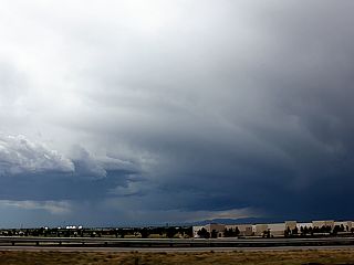
Developing high-based severe thunderstorm to the NW of Denver, CO ahead of the front-range. This storm would eventually produce a small derecho type event (straight line winds) with wind gusts to 80 MPH! |
|
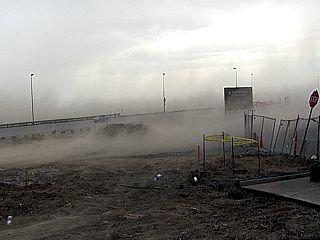
Derecho winds buffeting a gas station near Denver International Airport along Pena Boulevard. The winds here are over 60 MPH, with little rain, and kicking up a lot of dust and some debris. |
|
Jarred view of inside of airplane (Boeing 737) while trying to pick our way between and over some supercell storms in W OK / SE CO about a half hour after leaving Denver, CO en-route to Fort Lauderdale, Florida. This flight was delayed over an hour to begin with. The heavy turbulence (lasting nearly 20 minutes) was enough to lift you out of the seat, and made some people sick to the point they threw up. |
|
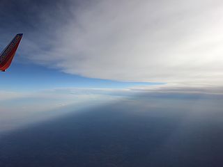
View over Oklahoma at about 37,000 feet with the edge of the storm anvil high above us and shadowing across the landscape. After this point, the flight remained smooth until landing at Fort Lauderdale, Florida. |
| CHASER NAME | HOME CITY | CALLSIGN | CHASE DATES | OCCUPATION |
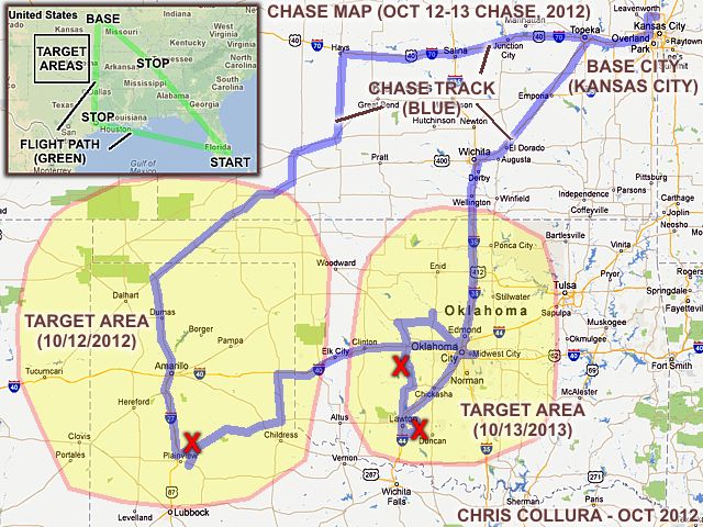
| CHRIS COLLURA | MIAMI, FL | KG4PJN | 10-11 TO 10-14 | IT CONSULTANT |
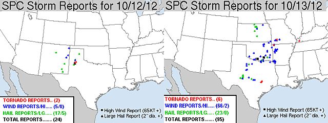
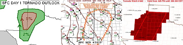
1). Oct 12, 7:00 PM - Interception, observation, and indirect penetration of a very severe and tornadic thunderstorm to the northeast of Plainview, Texas in Hale County and near Highways 86 and 207 and east of Interstate 27. The storm was a classic to HP supercell storm. Two small tornadoes were observed with this storm. The first one was a brief tornado under a large wall cloud, and the second was with another "cycle" of the supercell that was multi vortex in nature. The tornadoes were brief and probably EF-1 or less. No damage was observed as the storm was over open country. The core of the storm was not directly penetrated, and contained hail to at least baseball sized. Quarter to golfball sized hail was encountered northeast of the storm when diverting around the core to get into position for the tornadoes. The storm also had 60 MPH winds, frequent lightning (with some close hits), and very heavy rains. The storm had a very striking visual appearance as well (striations, vault, and ominous wall cloud). The storm was caused by a dryline and stationary front interaction, surface heating, upper trough, and developing low pressure system. A 2012 Dodge Avenger was used to chase the storm. Documentation was audio, digital stills, and HD video. A tornado watch was also in effect for the area until 2 AM CDT.
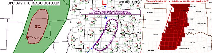
2). Oct 13, 4:00 PM - Observation of a severe thunderstorm near and to the southwest of Binger, Oklahoma in Caddo County and near Highways 152 and 146. The storm was part of a line / cluster of strong and severe thunderstorms, and possibly an embedded HP supercell storm. A rotating wall cloud was observed with this storm before it was undercut by outflow. An impressive shelf cloud (and "whale's mouth" effect) was observed with this storm. The storm also produced small hail, frequent lightning, very heavy / sideways rains, and winds gusting over 70 MPH. Some tree damage was observed as well. Conditions causing these storms were a Pacific cold front / dryline interactions, surface heating, upper trough, and low pressure system. A 2012 Dodge Avenger was used to chase the storm. Documentation was digital stills and HD video. A tornado watch was also in effect for the area until 9 PM CDT.
3). Oct 13, 5:30 PM - Observation of another severe thunderstorm near Lawton, Oklahoma in Comanche County and near Highways 7 and 65 and east of Interstate 27. The storm was an HP (or even classic) supercell storm. A rotating wall cloud and rain curtains was encountered east of Lawton and south towards Walters, where a small funnel was also observed. The storm contained 60 MPH winds, lightning, heavy rains, and hail about the size of quarters. Conditions causing the storm was an advancing dryline (south of it's intersection with a Pacific cold front), surface heating, upper trough, and low pressure system. A 2012 Dodge Avenger was used to chase the storm. Documentation was digital stills and HD video. A tornado watch was also in effect for the area until 9 PM CDT.
This concludes the Chase Log for the central US Plains and Midwest tornado chase trip from October 11 through October 14, 2012. The summary includes a total of 3 severe thunderstorms and at least 2 separate tornadoes. The main chase vehicle conducting all chases was a 2012 Dodge Avenger. This information was prepared exclusively for the National Weather service and the team of Skywarn storm spotters.
|
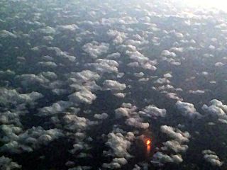
While flying out from Florida (Fort Lauderdale) to stop in Houston, TX (and finally kansas City, MO), I passed over the northern Gulf of Mexico. In this image, a bright yellow oil / gas flare (fire) from an offshore oil platform shines brightly below a layer of cumulus clouds. This was from an altitude of about 36,000 feet. |
|
Convective initiation ocurring along the stationary frontal boundary and dryline intersection to the northeast of Plainview, Texas (entering Hale County) while heading down Interstate 27. This was the northern split storm of the supercell that would move north and weaken, with the southern storm producing the severe weather. |
|
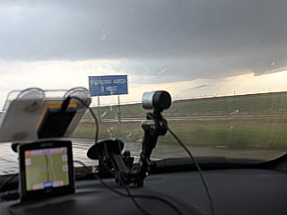
Brief view of the base of the northern split supercell from I-27 with dash cam, GPS, and equipment affixed to the rental vehicle. |
|
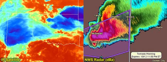
Brief tornado to the left, and large wall cloud of the southern supercell storm in Hale County, Texas. Time is roughly 7PM CDT. Hail as big as golfballs was falling just north of where this picture was taken (up to baseball sized farther west near I-27)! |
|
Radar (reflectivity) image, and my GPS position (white indicator circle) amongst other chasers, of the Plainview / Hale County supercell storm. |
|
Rapidly rotating wall cloud as the Hale County storm cycles back up. The view is due west. Note the large RFD clear slot! |
|
Tornado #2 of the Hale County storm at time of RFD occlusion. The view is to the WSW. This was a weak tornado, but multi-vortex in nature. |
|
Chaser "convergence" along a farm road in open country of Hale County as the supercell storm moves to the north of the area. |
|
Intense CG (Cloud to Ground) lightning strike as the supercell storm moves northeast of Hale County near dusk and weakens. This storm was a very prolific lightning producer. |
|
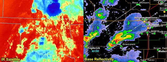
Slightly rotating wall cloud southwest of Binger, Oklahoma from an HP supercell storm embedded in a line / cluster of strong and severe thunderstorms that developed by early afternoon on October 13, 2012. |
|
Backside of intense gust front as outflow undercuts the Binger, OK HP supercell storm. The precipitation core of this storm has wind gusts over 70 MPH. |
|
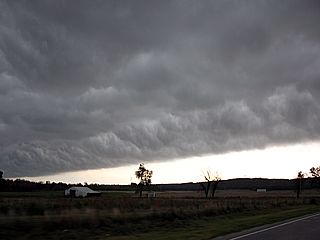
Backside of shelf cloud from a line of severe storms south of Binger, Oklahoma. |
|
Radar (reflectivity) image of a supercell storm that formed and passed near Lawton, Oklahoma. |
|
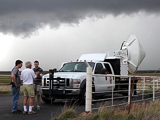
Here is Howie Bluestein and his group with the rapid-scan smart DOW (Doppler On Wheels) just east of Lawton, Oklahoma scanning the supercell storm. |
|
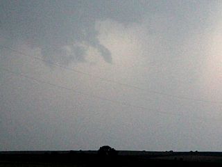
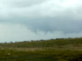
Sorry about the blur, but this was the old funnel cloud I was able to catch while straining over my right shoulder while north of Walters, Oklahoma and east of I-44 on the backside of the Lawton supercell. |
|
Shelf cloud associated with a severe thunderstorm developing along the Pacific cold front to the north of Lawton, OK and west of I-44. |
|
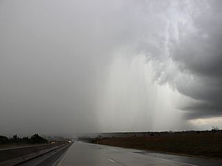
Intense precipitiation core of a severe storm cell along I-44 between Lawton and Oklahoma City. The hail would be just to the right of the roadway. |
|
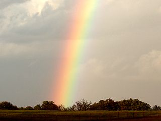
Closeup of intense rainbow after the storms passed on October 13 late in the day and SW of Oklahoma City, OK on I-44. Where's the "pot of gold" everyone talks about? |
|
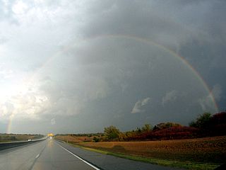
A full rainbow on the backside of a multicell severe storm complex viewed to the east along I-44 and south of Oklahoma City, OK. |
|
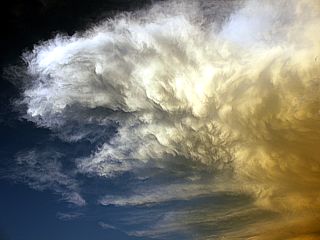
Anvil and back-sheared mammatus on the backside of a multicell storm cluster to the east of Oklahoma City, OK. |

|
Passengers on a delayed flight out of Kansas City, MO (to Las Vegas) were not too happy due to the weather. The cold core of the upper air portion of the system passed nearly directly over Kansas City during the morning of 10/14. Turbulence was very heavy flying out of this area. At one point a flight attendant bumped her head on the ceiling! |

|
View of cold-core cumulus clouds after connecting through Memphis, TN (en route to Florida from Kansas City). Turbulence finally subsided somewhere over northern Alabama. |
HTML File "mwcl2012.htm" - Developed By Chris Collura
To Return To The HOME Page Of This Site Click The "INDEX.HTM" Link Here!