
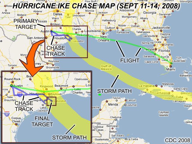
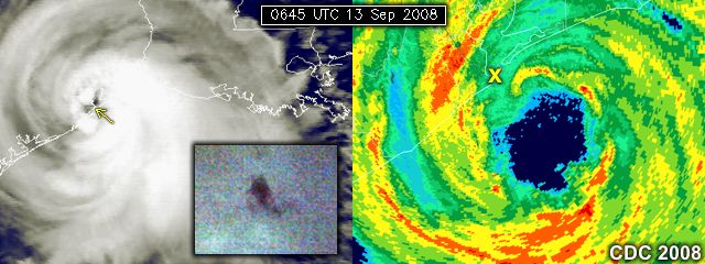
| This area shows pictures taken from the interception and observations of hurricane Ike in southeastern Texas from September 11 through September 14, 2008. Ike was a borderline category 2 to category 3 hurricane at landfall in Galveston Island during the late night of September 12-13. Hurricane Ike began as a tropical disturbance that came off the coast of Africa during late August of 2008. Ike started its long journey across the tropical Atlantic, intensifying as a tropical storm around the first of September, just as my group was wrapping up another hurricane chase on Gustav. During the first week in September, Ike became a hurricane and rapidly strengthened. Ike passed through the southeastern Bahamas, taking a direct hit on the Turks and Caicos Islands, and turned left - moving to the southwest - and made landfall in Cuba. Hurricane Ike weakened over the island of Cuba and re-emerged as a minimal hurricane in the southeastern Gulf of Mexico around September 9. The storm was very large and slow to recover from its rough trip over land, but began moving to the WNW and slowly strengthened across the Gulf of Mexico. Ike was a very large hurricane, and strengthened slowly until landfall on the night of September 12-13 in Galveston Island, Texas at roughly 2-3 AM CDT with winds at least 110-MPH. Once past Galveston, the storm passed Houston and began its right turn (recurverature), turning to the NW, then N, then NNE. The storm weakened over land on September 13, and then became absorbed as a remnant low into a frontal system a day later on the 14th. September 11th through the 14th was my chase days on this storm, meeting up with Jason Foster (N3PRZ) after flying in (to Austin, TX) on the 11th. Storm interception was on September 12-13, and return was leaving Austin on the 14th. Main damage from hurricane Ike was from the large storm surge (at least 15 feet high) that affected Galveston Island. Wind damage was characteristic of a strong category-2 (borderline 3) hurricane on the Saffir-Simpson scale. Hurricane Ike, during its long swath, caused at least 120 deaths and a total of over 27 billion dollars in damage. Note - This page may take a while to load on some SLOWER connections! |
| CHASER NAME | HOME CITY | CALLSIGN | OCCUPATION |
| CHRIS COLLURA | MIRAMAR, FL | KG4PJN | COMPUTER ANALYST |
| JASON FOSTER | GAITHERSBURG, MD | N3PRZ | ARCHITECT |
The list above shows personnel who actively participated in this chase, including myself. Jason Foster was my back-up driver and chase partner. Jason and myself flew into Austin, Texas on September 11, 2008 to procure the rental vehicle, a 2008 Chrysler PT Cruiser and head to the primary target area of Freeport, Texas. Jason flew in from Maryland, while my flight was a bit earlier from Fort Lauderdale, Florida. Our chase area was from Freeport, with the final (adjusted) target of Galveston. After the chase, on September 13, we returned to Austin, and the following day (Sept 14), Jason took a Greyhound bus to Dallas, and flew back home to Maryland from there, while I flew back from Austin to Fort Lauderdale, FL.
URGENT - WEATHER MESSAGE
NATIONAL WEATHER SERVICE HOUSTON TX
LIFE THREATENING INUNDATION LIKELY!
ALL NEIGHBORHOODS...AND POSSIBLY ENTIRE COASTAL COMMUNITIES...
WILL BE INUNDATED DURING HIGH TIDE. PERSONS NOT HEEDING
EVACUATION ORDERS IN SINGLE FAMILY ONE OR TWO STORY HOMES WILL
FACE CERTAIN DEATH.
MANY RESIDENCES OF AVERAGE CONSTRUCTION
DIRECTLY ON THE COAST WILL BE DESTROYED. WIDESPREAD AND
DEVASTATING PERSONAL PROPERTY DAMAGE IS LIKELY ELSEWHERE.
VEHICLES LEFT BEHIND WILL LIKELY BE SWEPT AWAY. NUMEROUS ROADS WILL
BE SWAMPED...SOME MAY BE WASHED AWAY BY THE WATER.
ENTIRE FLOOD PRONE COASTAL COMMUNITIES WILL BE CUTOFF. WATER LEVELS
MAY EXCEED 9 FEET FOR MORE THAN A MILE INLAND. COASTAL RESIDENTS IN
MULTI-STORY FACILITIES RISK BEING CUTOFF.
CONDITIONS WILL BE WORSENED BY BATTERING WAVES. SUCH WAVES WILL
EXACERBATE PROPERTY DAMAGE...WITH MASSIVE DESTRUCTION OF HOMES
...INCLUDING THOSE OF BLOCK CONSTRUCTION.
DAMAGE FROM BEACH EROSION COULD TAKE YEARS TO REPAIR.
|
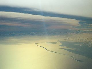
This is a picture of the marginal area of hurricane Ike seen from about 36,000 feet (from a commercial airliner) looking to the southwest on September 11, 2008 from over Apalachicola, Florida. The leading / northern edge of the cirrus canopy of hurricane Ike can clearly be seen extending across the picture from the right to the left. The barrier islands off Apalachicola can also be seen in this picture. |
|
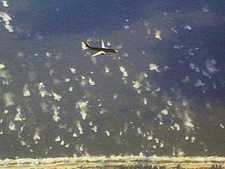
This is a picture looking down from a commercial airliner at 36,000 feet towards the coast of Alabama / Mississippi on September 11, 2008. Besides another airliner below us, one can easily make out the severely agitated state of the Gulf of Mexico surface and sea state, with breaking waves over 20 feet in height extending miles out, as well as the hurricane surf zone near the beach. |
|
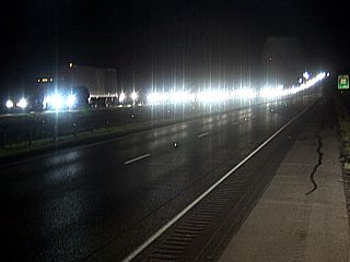
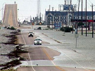
This is a picture of the massive evacuation traffic on Interstate 10 west of Kady, Texas (the view is to the east) during the late evening of September 11. No one is headed east in this picture, except for us! |
|
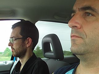
Here is a picture of myself (left) driving, and chase partner Jason Foster (N3PRZ) on the morning of September 12 leaving Rosenberg, Texas and headed to Freeport. |
|
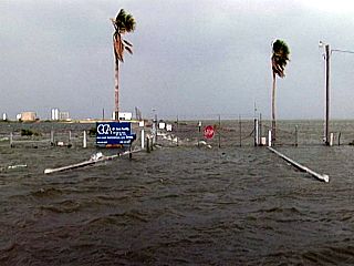
This is the closed (police blockade in place) causeway to Freeport, Texas (a fishing town) just south of Brazoria (a refining town). Even during the early morning of September 12, the rising Gulf of Mexico waters are causing major flooding problems. A portion of the causeway is already impassible. Freeport was our original target, but then was adjusted to Galveston, to be to the right of the storm track. |
|
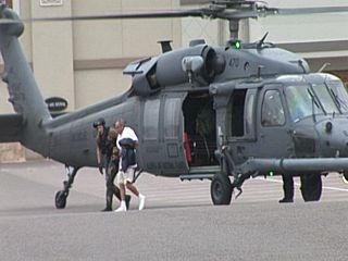
Here is a picture of one of the first daring rescues that took place in Galveston, Texas on September 12, 2008 as hurricane Ike was approaching the island. The large storm surge / waves arrived long before the winds of the storm itself, causing flooding and potential drowning from those who stayed behind. This lucky man is being turned over to local authorities for medical treatment after being air-rescued by Sikorsky Blackhawk helicopter. The landing area is in a shopping center parking lot. |
|
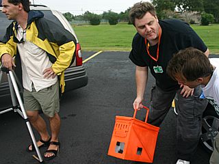
This is Dave Drummond, holding a protective camera housing, made from an ammunition case. Many storm chasers were in place in Galveston before, during, and after the storm. |
|
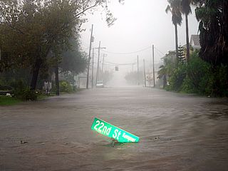
This is a flooded roadway near Texas City, Texas (a refining town) as the Houston / Galveston bay begins to rise from the storm surge. You were also able to see large rats fleeing the rising waters and crossing the road. |
|
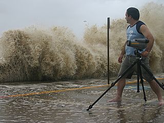
Here is a picture of myself, taken by Jason Foster (N3PRZ), standing in front of the seawall at Galveston, Texas during the day on September 12, 2008. Giant waves are crashing over the 17 foot high breakwater as I am taking pictures. |
|
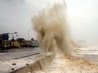
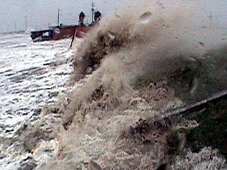
Here is another picture of a large wave smashing into the seawall at Galveston on September 12, sending spray more than 50 feet into the air. |
|
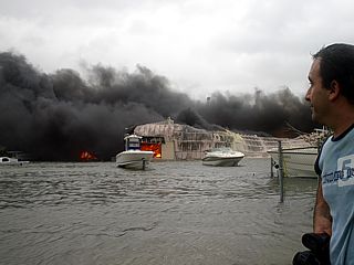
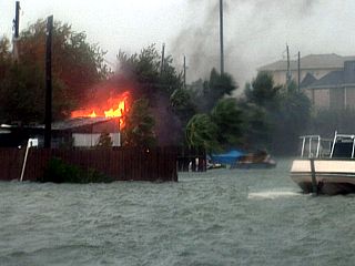
This is another picture, taken by Jason Foster (N3PRZ), of myself amongst others watching a fire breaking out in a building along a canal near the UT medical center on Galveston Island. Note the water in the foreground - That is rising storm surge, and not a canal or lake! If you look closely, the boats are on trailers and a submerged pickup truck can be seen to the left. The rising water was a big problem with hurricane Ike, as it shorted out electrical equipment / batteries and started fires. No fire fighters were able to reach these fires because of the flooding. |
|
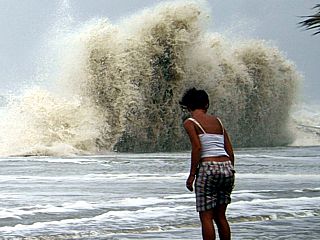
This young woman, appearing sad and distraught, was watching the rising storm surge and hurricane surf crashing into the seawall. She turned away and tossed a small yellow flower she was holding. She was one of many who ignored mandatory evacuations. |
|
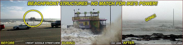
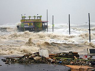
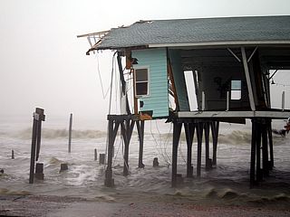
Here is a picture of one of many doomed structures either on or along the Gulf coast / Seawall Blvd. With hurricane Ike still hours away and conditions "ramping-up", such structures are no match for nature's fury. After the storm, there was no trace of this structure and pier. |
|
Here is a picture (taken from video by Jason Foster) of myself sampling winds gusting near 100-MPH on the I-45 causeway between Galveston Island and the mainland. I consistently measured sustained winds from 75-80 MPH at about 100 feet above the bay. The storm core is still about 100 miles away. |
|
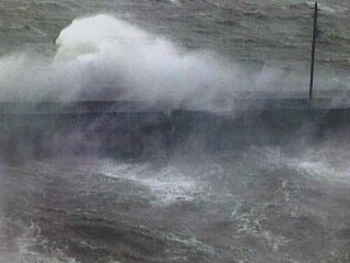
This is a picture of the Galveston Bay conditions near the I-45 causeway. Visibility is seriously reduced as spray and waves crash over the rail-road bridge adjacent to the causeway. Winds over 80-MPH are whipping up the bay. |

|
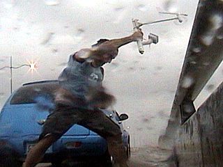
Here is a picture of my face in 80-100 MPH wind gusts as the core of hurricane Ike nears my location on the I-45 causeway. My face is clearly rippling and distorted by the strong winds! |
|
Another fire breaks out in a trailer park adjacent to the I-45 causeway in Galveston as the storm surge rises (normally this area is high and dry, the boat to the right is on a trailer). Rising salt water often causes electrical shorts. Even if the main power grid is out, batteries and equipment could still produce a spark and start a fire (especially in areas where fuel is involved, such as vehicles or boats) when wet by conducting salt-water. |
|
Here is the storm surge rising with battering waves smashing into the eastern end of Galveston Island late in the day on September 12 near Ferry point. The structure to the upper-left is a seafood restaurant is will soon be obliterated. |
|
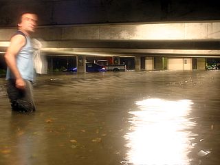
This is the first floor of a parking garage for the Galveston UT medical center just before the worst part of the storm arrived on September 12. A scene disturbingly reminiscent of hurricane Katrina unfolds due to a 15-20 foot storm surge affecting the island. The water here is still rising. Lights are still on because it is part of a hospital, and powered by a backup generator, making for a good location for hurricane chasing at night. |
|
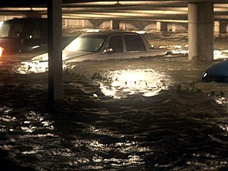
Here is another view of the entrance to the first floor of the parking garage at UT medical center in Galveston. The cars begin floating in the rising storm surge waters. |
|
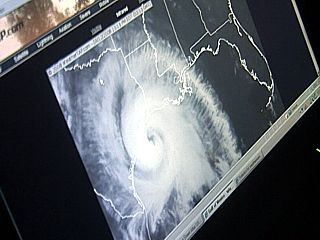
An ominous image of hurricane Ike is displayed via infrared satellite on the laptop computer just as the eye is moving in while we wait / hunker down at the UTMC (University of Texas medical center) parking area. The eye of the storm is just about to pass right over us. Hospitals are fantastic places for hurricane chasing at night because they offer a sturdy structure and power / lights often stays on because they run backup generators. |
|
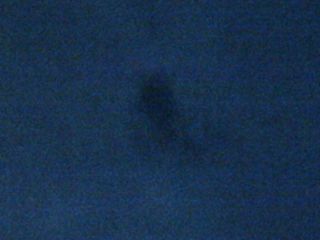
Here is a view, taken from enhanced video, of a clearing directly overhead inside the calm eye of hurricane Ike. The surrounding clouds are lit (brighter) entirely by light from the nearly full moon. The moon itself is lower in the sky and not overhead. The dark "swirl" in the center of the image is clear night sky peeking through a "hole" in the higher level clouds over the eye of the hurricane. |

|
An eerie thin fog envelopes the UT medical center and parts of Galveston during the calm eye of hurricane Ike. This fog is caused by the stable (sinking) air and moisture / spray at low levels in a hurricane's core. |
|
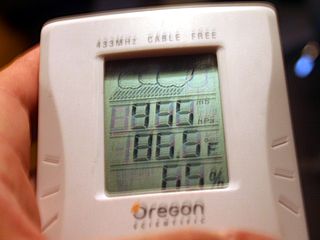
Lowest barometric pressure we measured inside the calm eye of hurricane Ike was 955 MB, a bit higher than the 952 "official" standing. This is simply because we may not be EXACTLY at the pressure-centroid of the large eye. |
|
Any structure close to or on the Gulf of Mexico was no match for the brute force of the hurricane surf and surge. This structure was completely gutted by wind and wave action during hurricane Ike in Galveston, along Seawall Blvd. |
|
Street flooding was severe during hurricane Ike in Galveston towards the last half of the hurricane on September 13, 2008. Most roads were impassible due to high water. |
|
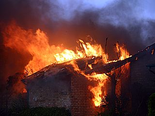
This is a picture of one of many fires encountered during hurricane Ike's wrath over Galveston. Rising surge / salt water causes electrical short-circuits and fires break out. This burning home was at the end of a row of six townhomes and villas, and was the first of the six homes to completely burn down. During the storm, firefighters and other emergency personnel simply cannot help anyone. After the storm, lack of water and power makes the situation even more hopeless. All six homes were reduced to charred remains in a mere hour’s time. |
|
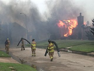
Fire fighters eventually arrived, although way too late, to douse the smoldering remains of the row of homes. There was no city water so hydrants were useless. The only way to fight the fires was to pump salt water from the street (storm surge flooding). The firemen here are carrying the pickup hoses to the water’s edge as the homes continue to burn to the right. |
|
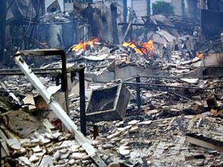
Here is what is left of the first flood of the first home to burn. Red-hot embers can be seen covering the floor, with the only materials remaining being the brick / concrete. |
|
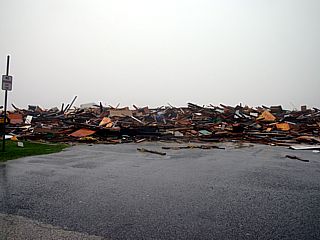
A debris line marks the extent of the storm surge after the storm along and near Seawall, Blvd during the morning of September 13. This debris field consists mainly of piers and ocean-front buildings that disintegrated from the brute force of the hurricane surf and / or tidal surge. |
|
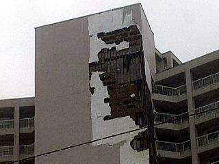
Severe wind damage to a hotel / condominium building in Galveston. |
|
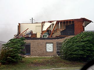
Here is more wind damage to an apartment complex in Galveston. The entire roof has been ripped off, wind-ward walls collapsed, and interior rooms exposed. |
|
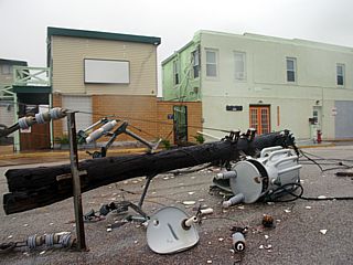
This is a picture of one of many utility poles that were destroyed during the storm. Power is often out for weeks after a hurricane. |
|
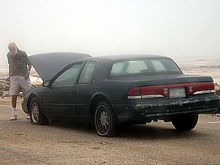
Many residents in Galveston failed to evacuate and attempted to drive their vehicles after the storm subsided. Driving in debris-strewn and / or flooded streets is bound to wreck havoc on any small vehicle. This man's car stalled as his engine got wet and sharp objects (glass, nails, etc) caused two flat tires. Getting stuck after a storm is very bad because no one will help you as they are attending to far more pressing circumstances (such as rescues). |
|
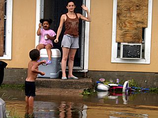
Here are some residents who stayed behind and "rode out" the storm in Galveston. This is definitely NOT a good idea as it often takes a long time for such people to get help. This family is in front of their home watching the water going down after the storm. |
|
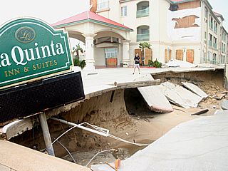
This La Quinta hotel along Seawall Blvd had its entire parking lot undermined by the storm surge. The building also suffered extensive wind damage. Note the size of the erosion path compared to Jason Foster standing in the middle of the picture. |
|
Here is a picture of one of several daring rescues. Two people drove a truck out onto a "seemingly" sturdy structure just before it collapsed. The structure was destroyed, leaving it cut-off and only the top of the first floor / roof remaining. The only way to bring the two to safety was via a Blackhawk helicopter rescue mission. The rescuer is dangling at the end of a long line and being lowered to the rooftop. A basket / breeches-buoy is where the person to be rescued will sit and be brought off the rooftop. |
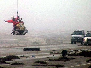
|
This is one of the two people being lowered to safety and hands of the authorities by breeches-buoy. The rescue swimmer is signaling the pilot above in the Sirkorsky Blackhawk that they are near their "landing spot" on Seawall Blvd. Such a mission is a skill to master, especially by the pilot flying the helicopter in strong winds and bad weather, as you have lives literally "on the line". The two people who were rescued walked away from this, and were very lucky, and would have faced certain death had the rooftop they were on collapsed (it almost did). |
|
Here is a picture of a small runabout boat laying in the middle of the street after the waters receded in Galveston Island. |
|
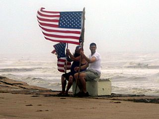
These local people, who stayed behind and rode out the storm, fly the American flag and are grateful they survived the worst of hurricane Ike. |
|
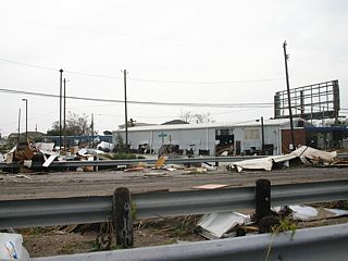
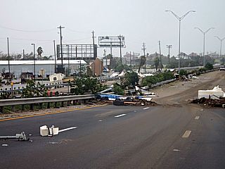
Here is a picture of damage along Interstate 45 in Galveston. Debris and sheet metal litters the street late in the day on September 13, 2008. |
|
Here is a picture of more damage and debris across the street along Interstate 45 in Galveston. A large plastic fuel tank can be seen to the right. |
|
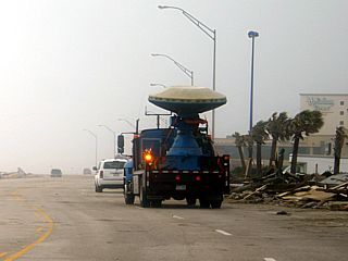
The DOW (Doppler on Wheels) truck can be seen here driving up and down along Seawall Blvd in Galveston after the storm. This is a radar dish mounted on a truck, and commonly seen in tornado alley (central USA) in the spring. In land falling tropical cyclones, this radar / research vehicle is interested in boundary-layer vortices and eyewall wind dynamics. |
|
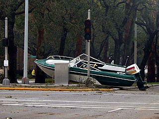
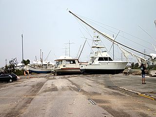
This is a picture of the Interstate 45 causeway that connects Galveston to the mainland. The highway is strewn with large boats and debris after the storm on September 13, 2008. |
|
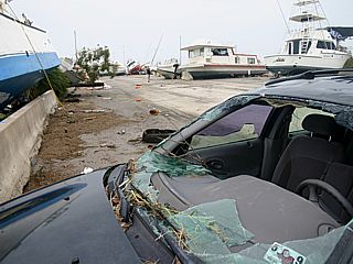
A car (Buick) lays in shambles next to marooned boats along Interstate 45 in Galveston during the afternoon of September 13. |
|
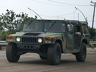
With Marshall-Law in effect, the military (US Army) comes into Galveston to help keep order and deal with Federal disaster area operations. In this picture, a jeep is headed onto the island. |
|
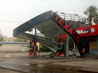
Gas station canopies are often destroyed in hurricanes, like this one in Galveston, Texas, after the storm on September 13. |
|
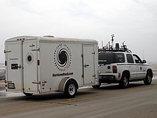
Here is Mark Suddath's hurricane chasing vehicle and trailer, which houses instrumentation. Many hurricane / storm chasers came to Galveston for hurricane Ike. |
|
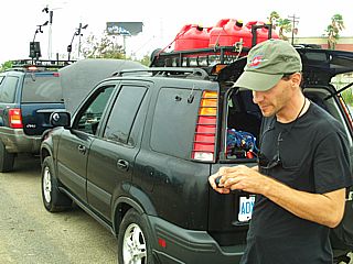
Here is George Kourounis, from Toronto, Canada, who was also chasing hurricane Ike (after wrapping up with hurricane Gustav just 2 weeks prior). While crossing high waters, his vehicle stalled, and needed to be towed out by a fellow chase partner. |
|
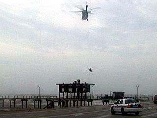
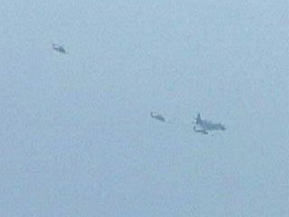
With continuous air-rescue "sorties" taking place, and no viable airfield nearby, the Sikorsky Blackhawk helicopters meet a KC-130 tanker aircraft continually circling over Galveston Island to take on fuel. |
|
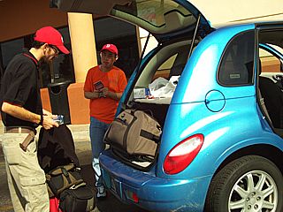
Here is Jason Foster and the PT Cruiser chase vehicle back in Austin, Texas (at a Greyhound bus terminal) on September 14. Jason will leave from here to Dallas, and fly home from there. I am still waiting to fly back home out of Austin. The man in the background is a refugee (who evacuated) from Houston and is trying to find a ride back to his family there. |
HTML File "ike08.htm" - Developed By Chris Collura
To Return To The HOME Page Of This Site Click The "INDEX.HTM" Link Here!