
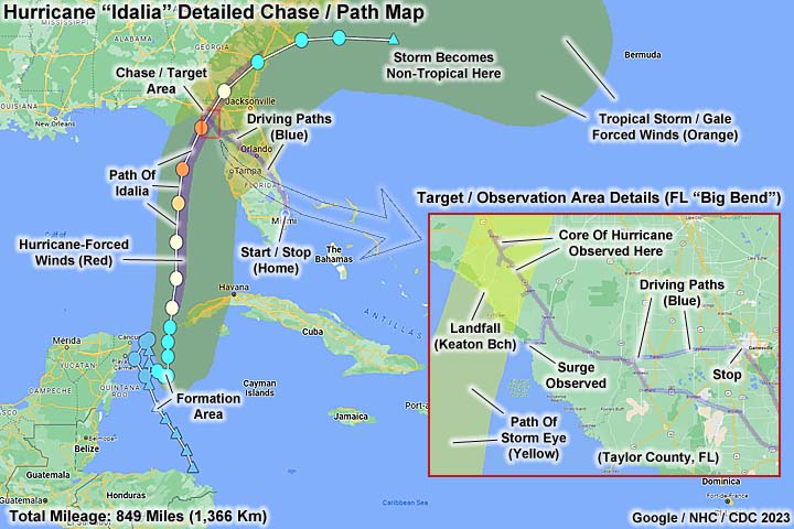
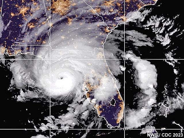
| Hurricane Idalia was a powerful hurricane and the only major hurricane to hit the United States during the Atlantic hurricane season of 2023. The storm first formed during the period from August 24 to 26, owing from a monsoon trough over Central America. Once developed, a tropical depression, then a tropical storm, meandered and intensified between the Yucatan Peninsula and Cuba from August 27 and 29, moving northward later in the period into the southeastern Gulf Of Mexico. Lessening vertical wind shear and very warm waters favored rapid intensification once a storm core developed (eyewall), especially on August 29 where it reached hurricane strength. The storm continued northward, still rapidly intensifying, until it neared landfall in the Florida "Big-Bend" area, and briefly reached category 4 strength early on August 30. The storm had a very large gale (tropical storm) forced wind envelope, extending out at least 150 miles from the center, with a smaller core of hurricane forced winds extending out only 25 miles. The storm briefly became a category 4 storm, with 130 MPH winds and a central pressure of 940 MB, before weakening slightly to 125 MPH (due to the start of an eyewall replacement cycle), where it made landfall near Keaton Beach, in Taylor County, Florida. The storm continued to the NNE, passing over or near the town of Perry, Florida and near Athena. Once over land, the storm encountered drag and was cut off from the warm Gulf waters, and began weakening rapidly under increasing vertical shear as it continued to the Georgia border by mid-day on August 30. The storm weakened to a tropical storm, and re-emerged into the Atlantic Ocean on August 31 near South Carolina. By this point the storm structure was sheared apart by hostile atmospheric conditions (vertical shear and dry air), and the storm became extra-tropical well southeast and east of the Carolinas. The post-tropical low of Idalia passed near Bermuda on September 2, finally becoming absorbed in a low pressure trough there after. This storm caused major wind damage, and storm surge over a large area in the Florida "Big-Bend" area. At least 12 people were killed and damage was up to 4 billion dollars. Note - This page may take a while to load on some SLOWER connections! |
HURRICANE IDALIA - TROUBLE IN THE FLORIDA BIG-BEND
| CHASER NAME | HOME CITY | CALLSIGN | OCCUPATION |
| CHRIS COLLURA | DEERFIELD BEACH, FL | KG4PJN | COMPUTER ANALYST |

|
Gas stations often run out of gas when a hurricane threatens. Luckily we carry extra fuel containers when we go hurricane chasing. |

|
Storm chasers and news crews at a Hampton Inn in Perry, Florida waiting for hurricane Idalia to arrive. This was before Dawn on August 30, 2023. |

|
Tim Marshall ("tornado Tim") at a parking lot in Perry, Florida before sunrise. Many storm chasers were chasing this hurricane. |
|
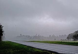
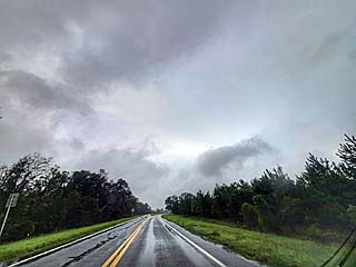
Positioning south of Perry, Florida near Athena to ride out the front eyewall of hurricane Idalia. The outer eyewall is about to pass over me as the sun comes up. |
|
Front eyewall reaches Athena, Florida after day break. Winds briefly gusted over 100 MPH in this area, but rain was rather light. |
|
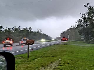
View of brightening sky looking south near Athena, Florida as winds gust over 100 MPH. The eye is coming fast. The vehicles in this view are all storm chasers. |
|
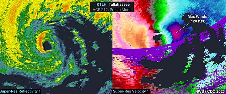
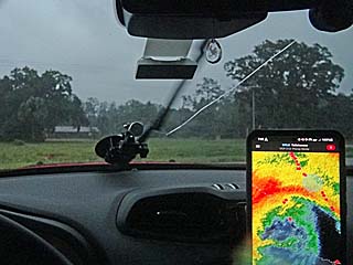
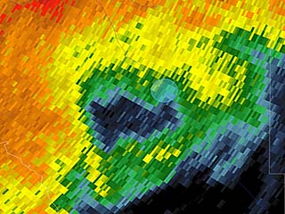
Radar image (base reflectivity) and my position (blue circle) just entering the small inner-eye (a "pinhole" eye, less than 8 miles wide) of hurricane Idalia near Perry, Florida. |
|
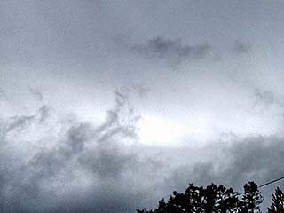
Brief wide-angle view of the inside of hurricane Idalia's eye at about 8:30 AM EDT just east of Perry, Florida. Note the brief view of hazy blue sky (just left of center of picture and a bit right)! This eye was very small, less than 8 miles wide, and with the storm moving NNE at nearly 20 MPH, it left little time to enjoy the calm conditions. |
|
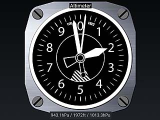
Barometric pressure bottomed out in the eye between Athena and Perry at 943.1 MB. For you aviation buffs, note that almost 2,000 feet of the lower atmosphere is "missing"! |
|
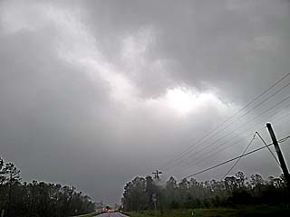
Brief view of the eyewall (and stadium effect) across the lower portion of this picture, from left to right. The eye was clouded over with high clouds, with hazy blue sky visible at times. |
|
The calm of the small eye was short lived as the backside of the hurricane approaches and the bright skies give way quickly to rain and winds from the opposite direction. The rear eye-wall can be seen approaching from left to right in this view (to the west). |
|
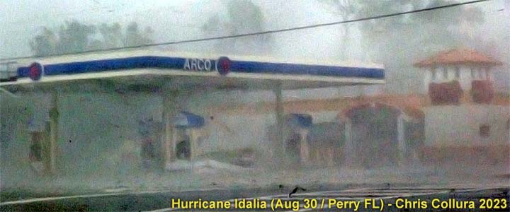
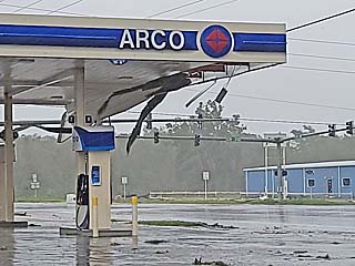
Winds begin to pick up, from the northwest (opposed to southeast) as the backside of hurricane Idalia slams Perry. Here a gas station canopy begins to peel just before the main eyewall returns. |
|
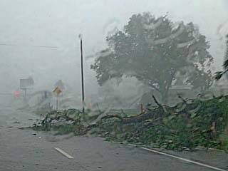
Ferocious winds of the backside eyewall of Idalia fell trees in Perry, Florida. The conditions on the backside of the hurricane were much wetter than the front side of the eyewall. |
|
Storm chaser (I think this is Tim Marshall) negotiating downed trees as the rear eyewall of hurricane Idalia affects Perry. |
|
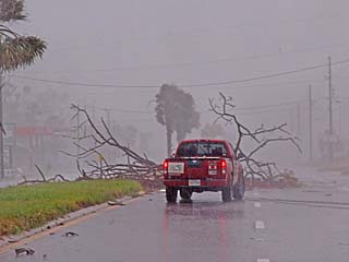
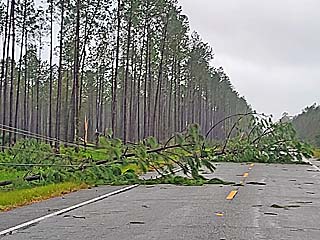
Some downed trees blocking the roadway towards Steinhatchee, Florida. The winds here remained tropical storm forced, with most of the core of hurricane Idalia passing just offshore of the area. Storm surge, however, had far-reaching effects south of the storm. |
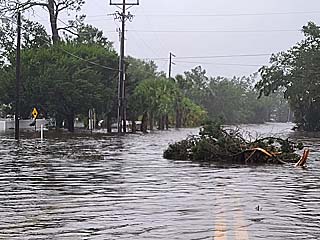
|
Extreme flooding in Steinhatchee, Florida on the backside of hurricane Idalia as water from the Gulf of Mexico pushes inland. This is a street covered by the storm surge. |
|
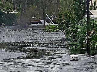
Another street and homes flooded by the surge in Steinhatchee, Florida. Note the pulpit of a yacht to the upper left poking through the trees, as well as the mailboxes submerged. |
|
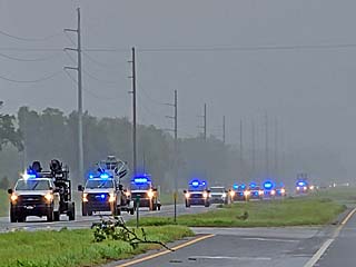
Utility vehicles headed towards the areas impacted after the storm. |
|
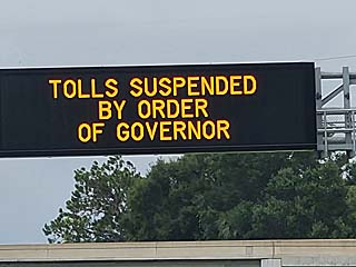
Most toll roads from Orlando, Florida and northwestwards were suspended, so no tolls were being charged. |
HTML File "idal23.htm" - Developed By Chris Collura
To Return To The HOME Page Of This Site Click The "INDEX.HTM" Link Here!