
Facebook Timeline Posts For May 2013
(Posts And Comments During May 2013 For Sky-Chaser Chris Collura On Facebook)
[ 2013-JUN ] [ BACK TO INDEX ] [ 2013-APR ]
Posts And Comments For May 2013
Posted: May 31, 2013, 11:47 PM
Chris Collura updated his status.
Here in Oklahoma City for the night. Vehicle to be exchanged tomorrow morning first thing from rental company. I'm done chasing, and it's been nuts!
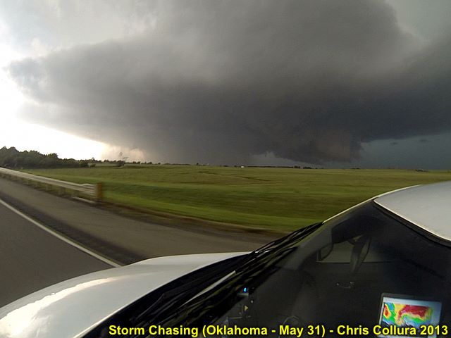
Posted: May 31, 2013, 11:45 PM
Chris Collura added a new photo.

Wedge tornado approaching El Reno, Oklahoma on May 31.
Posted: May 31, 2013, 11:45 PM
Chris Collura added a new photo.
Wedge tornado and chase vehicle - Near El Reno, Oklahoma on May 31, 2013.
Posted: May 31, 2013, 11:45 PM
Chris Collura added a new photo.
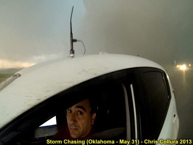
Yes - I'm scared ... A developing violent tornado is a couple of hundred of feet behind me and I'm in the 100 Kt inflow jets! Yikes! May 31, south of El Reno, OK.
Posted: May 31, 2013, 11:45 PM
Chris Collura added a new photo.
Wedge tornado - Near El Reno, Oklahoma on May 31, 2013.
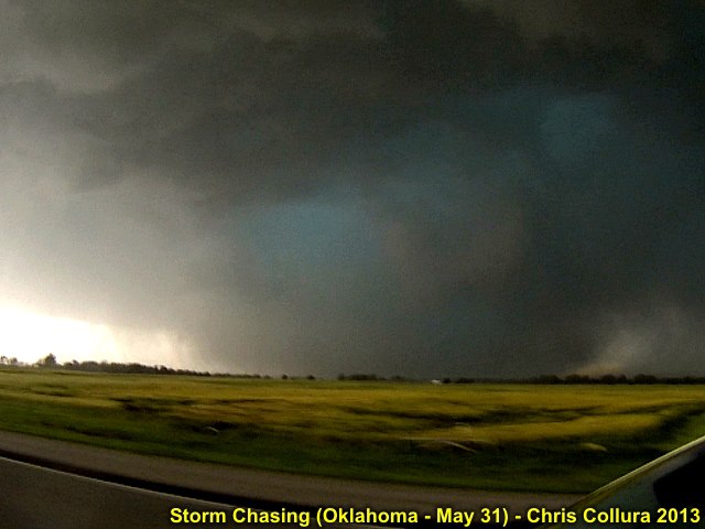
Posted: May 31, 2013, 11:45 PM
Chris Collura added a new photo.
Wedge tornado moving away - Near El Reno, Oklahoma on May 31, 2013.
Posted: May 31, 2013, 11:45 PM
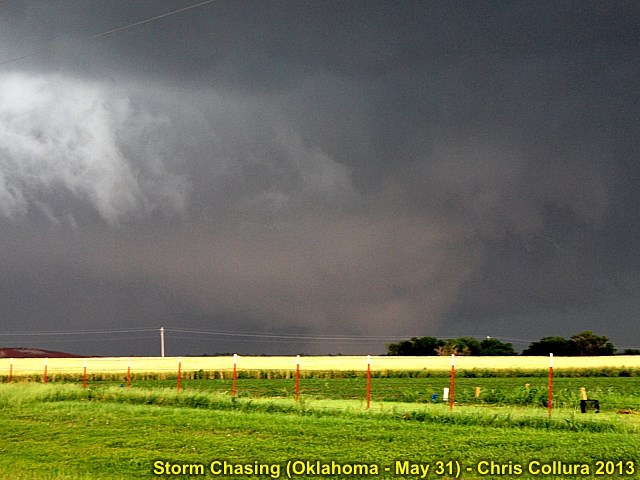
Chris Collura added a new photo.

Wedge tornado with rain wrap (there is even a barely visible satellite tornado to it's right)! - Near El Reno, Oklahoma on May 31, 2013.
Posted: May 31, 2013, 6:56 PM
Chris Collura updated his status.
I'm all right ... Reviewing whatever pictures I was able to salvage. Got into outer circulation of the wedge near el Reno! My ears hurt a bit, and my left hand is bruised from the rain hitting my hand holding the gopro while escaping! Now waiting in parking garage at OKC airport to exchange car once storms are done.
Posted: May 31, 2013, 4:47 PM
Chris Collura updated his status.
Nearly got sucked into a wedge tornado near El Reno OK! Wow!!
Posted: May 31, 2013, 1:36 PM
Chris Collura updated his status.
Here on El Reno OK in PDS tornado watch box. I can smell the Caribbean with dewpoints in mid 70's - wow! Violent time is ahead of us ... Stay safe everyone!
Posted: May 31, 2013, 11:52 AM
Chris Collura updated his status.
On the move southwest through Edmund, OK
Posted: May 31, 2013, 11:19 AM
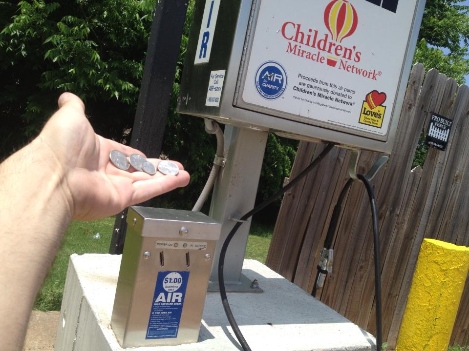
I wanna hit one of these things with a baseball bat! I fixed the flat with a plug in Guthrie but simply could not find an air hose - had 3 quarters, not 4. Destroyed the tire simply driving all over town looking for air ... Now a new tire. The air we breathe and some idiots charge for it :(
Posted: May 31, 2013, 10:33 AM
Chris Collura updated his status.
Sitting here in Guthrie OK looking at data. Scary seeing SPC mentioning violent tornadoes in their wording, with possible upgrade to high risk on 20z outlook. Just measured 75 dewpoint at 87 degrees. Stay safe everyone!
Posted: May 31, 2013, 6:44 AM
Chris Collura updated his status.
Got 'nother one ... Moderate risk (again) for OK and headed southward to north of OKC and points nearby. Last chase day then long drive back to Denver on Saturday! Initiation should be later today too ... Let's go!
Posted: May 30, 2013, 9:39 PM
Chris Collura added a new photo.
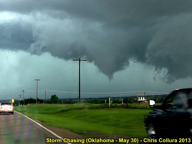
Brief tornado (some chasers closer in confirmed ground circulation briefly) near Perkins, OK on May 30.
Posted: May 30, 2013, 9:39 PM
Chris Collura added a new photo.

Developing brief tornado viewed from near Coyle, OK on May 30.
Posted: May 30, 2013, 9:39 PM
Chris Collura added a new photo.
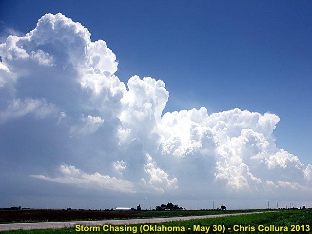
Developing supercell storms near Guthrie, Oklahoma on May 30.
Posted: May 30, 2013, 9:39 PM
Chris Collura added a new photo.
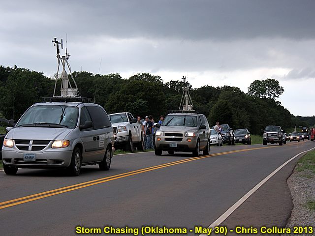
Chasers jamming the roads in Oklahoma near Agra, OK on May 30.
Posted: May 30, 2013, 6:01 PM
Chris Collura updated his status.
Interesting day with two supercells intercepted near Perkins OK and Guthrie. Small tornado observed!
Posted: May 30, 2013, 11:14 AM
Chris Collura updated his status.
Oh these lights in Enid!
Posted: May 30, 2013, 6:42 AM
Chris Collura updated his status.
Big CG jolts me out of bed this morning in Wichita ... Yup time to get up and head to Oklahoma - no alarm clock needed ... The moderate-risk spree continues!
Posted: May 30, 2013, 12:21 AM
Chris Collura added a new photo.
Mammatus looming above western Oklahoma on May 29, 2013.
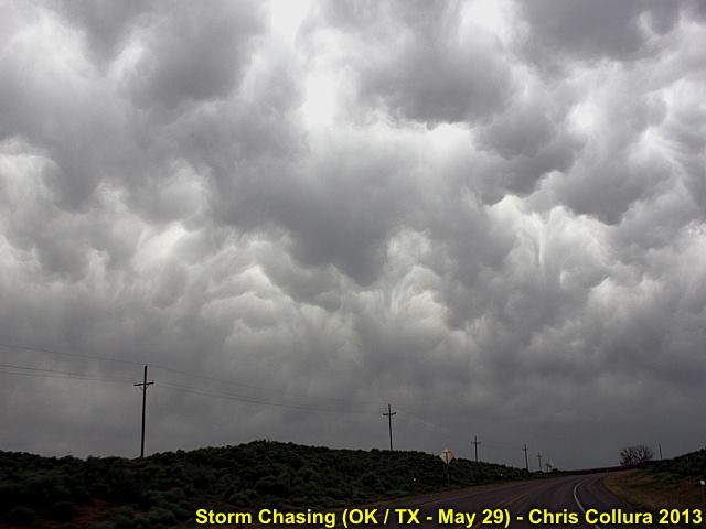
Posted: May 30, 2013, 12:21 AM
Chris Collura added a new photo.
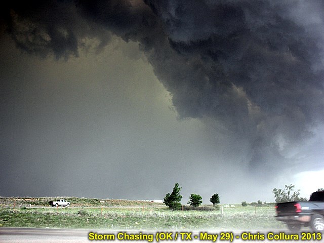
Powerful gust front and outflow ahead of a bowing-segment in a line of severe thunderstorms near Briscoe, Texas on May 29.
Posted: May 30, 2013, 12:19 AM
Chris Collura added a new photo.
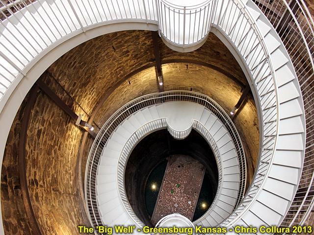
The 'Big Well' in Greensburg, Kansas in May 2013 - This is a hand dug well, about 110 feet deep, with clear water at the bottom (Ogalla Aquifer).
Posted: May 29, 2013, 3:39 PM
Chris Collura updated his status.
I really feel bad for anyone who missed the 5/28 tornado north of salina! What a junkfest today (5/29)!
Posted: May 29, 2013, 12:46 PM
Chris Collura updated his status.
Sitting here in booker, Texas with Tim Marshall and folks. Waiting for the dryline effects. Not sure about the convective junkfest in SW Kansas.
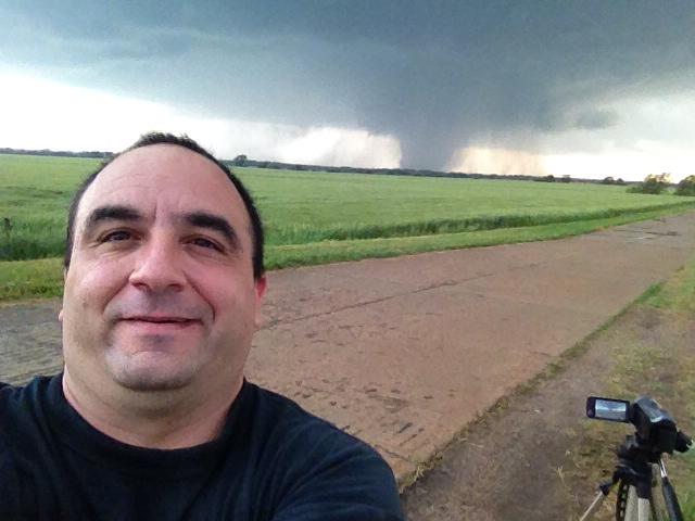
Posted: May 28, 2013, 8:57 PM
Chris Collura added a new photo.
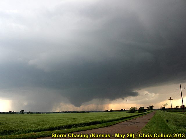
Developing large tornado west of Minneapolis, Kansas on May 28.
Posted: May 28, 2013, 8:57 PM
Chris Collura added a new photo.
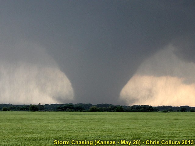
View of intensifying (potentially violent) tornado on May 28 near Minneapolis, Kansas.
Posted: May 28, 2013, 8:57 PM
Chris Collura added a new photo.
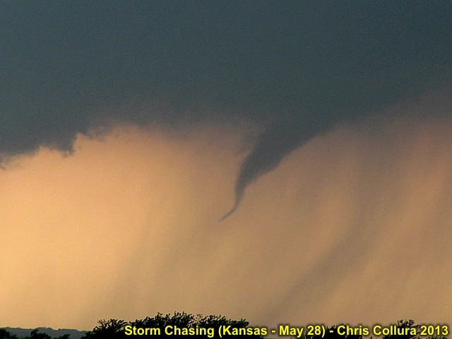
First funnel and small tornado developing on May 28 near Minneapolis, Kansas.
Posted: May 28, 2013, 8:57 PM
Chris Collura added a new photo.
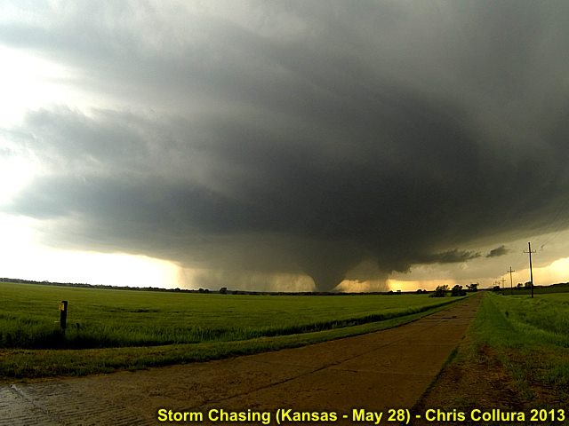
Wide angle view of developing strong tornado on May 28 near Minneapolis, Kansas.
Posted: May 28, 2013, 8:57 PM
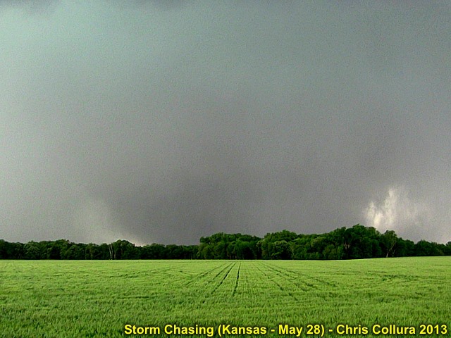
Chris Collura added a new photo.
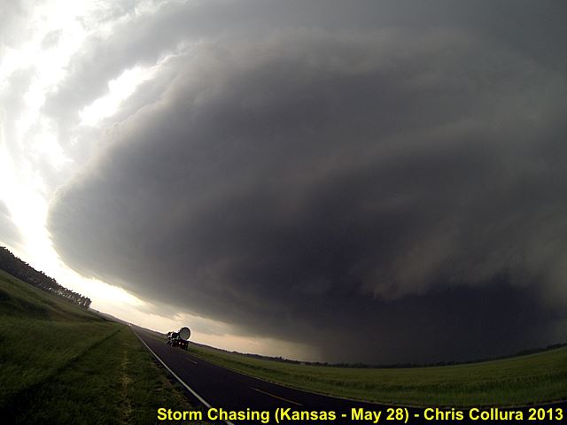
Supercell structure of the HP storm (the wedge tornado is now completely rain-wrapped) as the DOW (Doppler on Wheels) scans the storm. May 28 near Minneapolis, Kansas.
Posted: May 28, 2013, 8:57 PM
Chris Collura added a new photo.
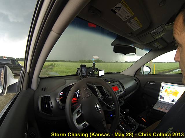
Myself in the chase vehicle (my 'office' for two weeks) near Minneapolis, Kansas on May 28, watching the wedge tornado becoming rain wrapped.
Posted: May 28, 2013, 8:57 PM
Chris Collura added a new photo.
Large (Wedge) tornado starting to become rain-wrapped while nearly stationary. Show looking west from near Minneapolis, Kansas on May 28.
Posted: May 28, 2013, 8:48 PM
Chris Collura updated his status.
What a day today (5/28) north of Salina Kansas ... Beautiful and violent supercell, produced a mile-wide wedge tornado... This is WHY we chase!
Posted: May 28, 2013, 3:56 PM
North of salina now!
Posted: May 28, 2013, 7:15 AM
Chris Collura updated his status.
May 28 - Possibly late check out of Hays. Not sure where to go yet (maybe HERE and just east / north like yesterday). The 5% tornado outlook spans across 2/3 of the country today (our job is to pinpoint WHERE)!
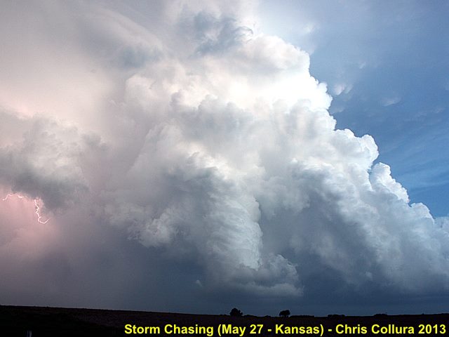
Posted: May 27, 2013, 9:50 PM
Chris Collura added a new photo.
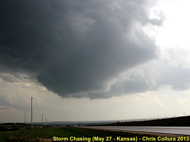
Rotating wall cloud / updraft over Osborne, Kansas - May 27, 2013.
Posted: May 27, 2013, 9:50 PM
Chris Collura added a new photo.
Tail-end supercell south of I-70 and west of Salina at dusk - Kansas - May 27, 2013.
Posted: May 27, 2013, 9:45 PM
Chris Collura updated his status.
Not a good day chasing today ... Disorganized supercells south of the rain-wrapped HP monster north in Smith County on May 27. The supercells south formed a line and junked out - So much for the MDT ey?
Posted: May 27, 2013, 6:31 AM
Chris Collura updated his status.
Oh, Boy ... Moderate risk today (again) in N/C Kansas ... Heading out the door as I'm typing this in North Platte, NE.
Posted: May 27, 2013, 12:07 AM
Chris Collura added a new photo.
Developing LP supercell in Custer County, Nebraska on May 26, 2013.
Posted: May 27, 2013, 12:07 AM
Chris Collura added a new photo.
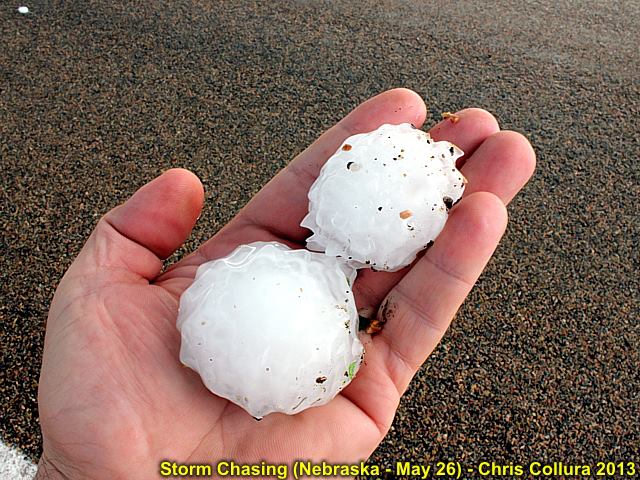
Large hail from passage of LP supercell in Custer County, Nebraska on May 26, 2013.
Posted: May 27, 2013, 12:00 AM
Chris Collura updated his status.
Big beautiful supercell storm on may 26 in Nebraska!
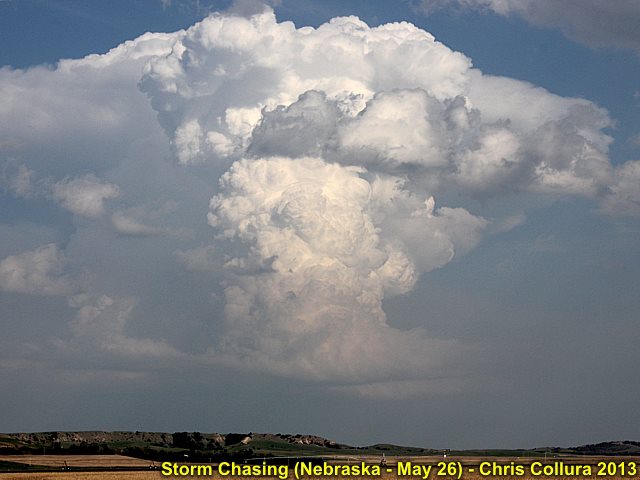
Posted: May 26, 2013, 11:50 PM
Chris Collura added a new photo.

"Mothership" appearance of LP supercell near Broken Bow, Nebraska on May 26, 2013.
Posted: May 26, 2013, 11:50 PM
Chris Collura added a new photo.

"Mothership" appearance of LP supercell near Broken Bow, Nebraska on May 26, 2013.
Posted: May 26, 2013, 11:50 PM
Chris Collura added a new photo.

Lightning and mammatus from weakening LP supercell in Nebraska on May 26, 2013.
Posted: May 26, 2013, 11:50 PM
Chris Collura added a new photo.

Wider shot of lightning and mammatus from weakening LP supercell in Nebraska on May 26, 2013.
Posted: May 26, 2013, 11:50 PM
Chris Collura added a new photo.
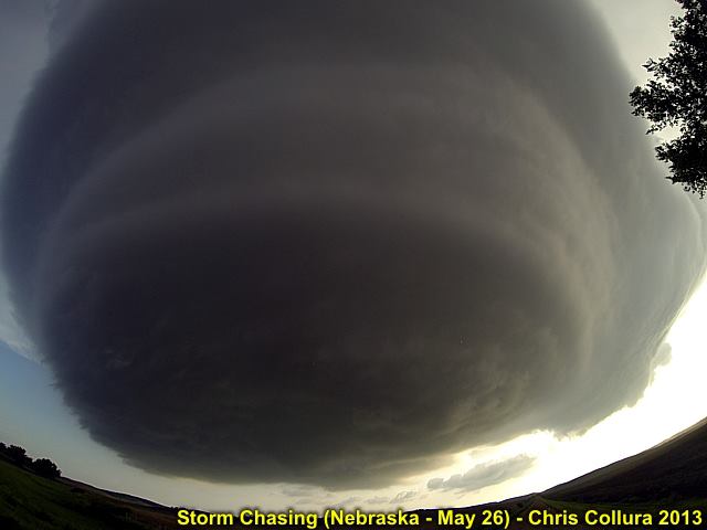
Incredible supercell structure - LP supercell north of Broken Bow, Nebraska on May 26, 2013.
Posted: May 25, 2013, 9:40 PM
Chris Collura updated his status.
May 25 was an interesting day that began with fixing a flat tire, long drive to SD, getting 'stuck' in the winding mountain roads near Mt Rushmore, getting a speeding ticket, and trying to salvage the day east of Rapid City, SD ... Alas the storm waited for me and produced some of the wildest storm structure I ever seen! This is WHY we chase ... And NOT give up chasing, no matter how hopeless it may seem!
Posted: May 25, 2013, 9:04 PM
Chris Collura added a new photo.

Some chasers under the 'meso' of the Rapid City, SD supercell on May 25, 2013.
Posted: May 25, 2013, 9:04 PM
Chris Collura added a new photo.

Impressive structure of the Rapid City, SD supercell on May 25, 2013.
Posted: May 25, 2013, 9:04 PM
Chris Collura added a new photo.

Weakening (downscale development) at dusk of the Rapid City, SD supercell on May 25, 2013.
Posted: May 25, 2013, 9:04 PM
Chris Collura added a new photo.
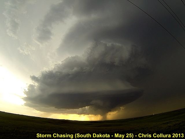
Storm structure with powerful RFD of the Rapid City, SD supercell on May 25, 2013.
Posted: May 25, 2013, 9:04 PM
Chris Collura added a new photo.
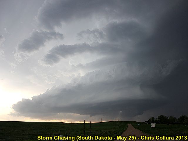
"Stacked-Plates" appearance of the SE side of the Rapid City, SD supercell on May 25, 2013.
Posted: May 25, 2013, 6:08 PM

Ahhhh ... Made it and I got to saw wow!
Posted: May 25, 2013, 5:01 PM
Chris Collura updated his status.
Stay away from Mount Rushmore on 385 ticket, missed supercell, and frustration well learned
Posted: May 25, 2013, 4:56 PM
Chris Collura updated his status.
Fuck me ... Ranger stopped me for 57 in 45 in park. $150 ticket ... What a difference a left turn made.
Posted: May 25, 2013, 4:35 PM
Chris Collura updated his status.
Major nav effup tODay! I'm in Mount Rushmore area! Raging SD supercell 40 miles NE of me :P
Posted: May 25, 2013, 6:41 AM
Chris Collura added a new photo.

Muddy road and hail core in the storm west of Doughtery, Texas on May 23. Photo taken by Clarence Bennett.
Posted: May 25, 2013, 6:41 AM
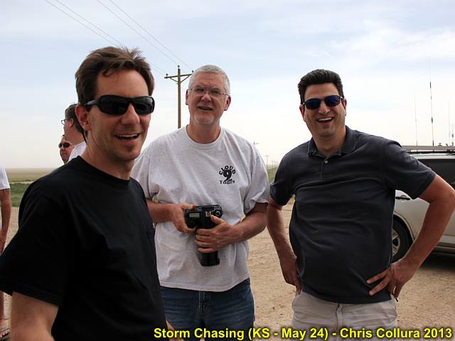
Chris Collura added a new photo.

"When YOU tell me the LCL's gonna be low - You BETTER mean it!" ... Having fun under the meso (May 24).
Posted: May 25, 2013, 5:51 AM
Chris Collura updated his status.
Nebraska chase appears to be on tap for today (5/25).
Posted: May 24, 2013, 10:25 PM
Chris Collura added a new photo.

LP Supercell NW of Goodland, Kansas on May 24.
Posted: May 24, 2013, 10:25 PM
Chris Collura added a new photo.

Hail falling near Cheyenne Wells, CO on May 24.
Posted: May 24, 2013, 10:25 PM
Chris Collura added a new photo.
Just a part of the chaser convergence near Sheridan Lake Colorado near an LP supercell (@[846940369:2048:George Kourounis], @[1072928661:2048:Charles Edwards], and @[100000442610383:2048:Daniel Shaw]) on May 24.
Posted: May 24, 2013, 10:25 PM
Chris Collura added a new photo.
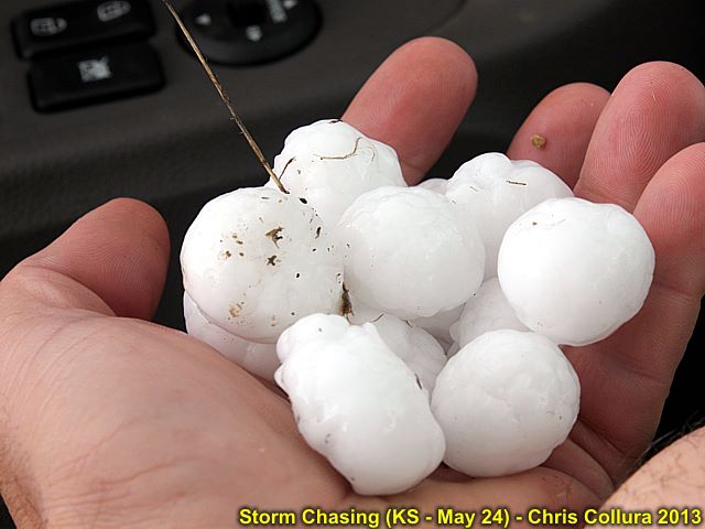
Hail near Cheyenne Wells, CO on May 24.
Posted: May 23, 2013, 11:14 PM
Chris Collura updated his status.
Caught two tornadoes today (May 23) in Texas panhandle along with two supercells, one producing winds gisting over a 100 MPH!
Posted: May 23, 2013, 11:06 PM
Chris Collura added a new photo.
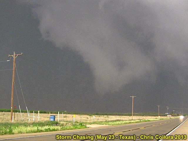
Second possible tornado near Rotan, Texas ... May 23, 2013.
Posted: May 23, 2013, 11:06 PM
Chris Collura added a new photo.

First tornado (or maybe just dust updrafting)? To the west of Dougherty, Texas and to the south of Highway 62. There is it - Peaking through the 60+ knots inflow dust! May 23, 2013.
Posted: May 23, 2013, 5:50 AM
Chris Collura updated his status.
Texas panhandle today ... Great night last night at the big Texan meeting up with such great chasers (Scott Scott McPartland, Dave Dave Lewison, Bill Hark, Chris Chris Kridler, amongst others)!
Posted: May 22, 2013, 10:28 PM
Chris Collura added a new photo.

Moore, Oklahoma tornado from May 20, 2013 (picture taken on May 22) - Tornado survivor holding his cat in front of his destroyed home.
Posted: May 22, 2013, 10:28 PM
Chris Collura added a new photo.

Moore, Oklahoma tornado from May 20, 2013 (picture taken on May 22) - Unrecognizable remains of homes / debris piled high by tornado.
Posted: May 22, 2013, 10:28 PM
Chris Collura added a new photo.
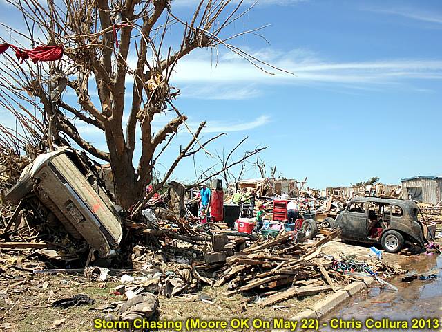
Moore, Oklahoma tornado from May 20, 2013 (picture taken on May 22) - Car in tree and destroyed home.
Posted: May 22, 2013, 10:28 PM
Chris Collura added a new photo.
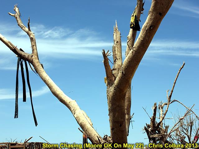
Moore, Oklahoma tornado from May 20, 2013 (picture taken on May 22) - Debarked tree.
Posted: May 22, 2013, 10:28 PM
Chris Collura added a new photo.

Moore, Oklahoma tornado from May 20, 2013 (picture taken on May 22) - Car buried in remnants of a home.
Posted: May 22, 2013, 10:28 PM
Chris Collura added a new photo.
Moore, Oklahoma tornado from May 20, 2013 (picture taken on May 22) - Sidewalk along path of destruction.
Posted: May 22, 2013, 10:28 PM
Chris Collura added a new photo.

Moore, Oklahoma tornado from May 20, 2013 (picture taken on May 22) - Completely flattened pickup truck (?).
Posted: May 22, 2013, 10:28 PM
Chris Collura added a new photo.

Moore, Oklahoma tornado from May 20, 2013 (picture taken on May 22) - Debris strewn across landscape.
Posted: May 22, 2013, 10:28 PM
Chris Collura added a new photo.
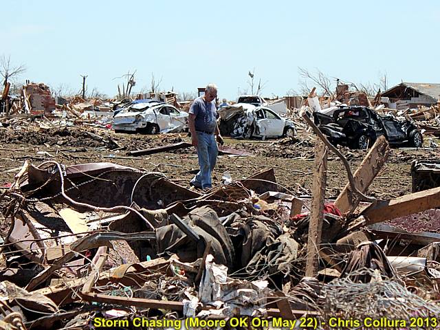
Moore, Oklahoma tornado from May 20, 2013 (picture taken on May 22) - Destroyed vehicle remains / man walking through debris.
Posted: May 22, 2013, 10:28 PM
Chris Collura added a new photo.
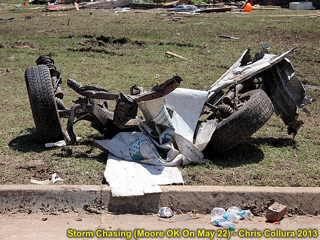
Moore, Oklahoma tornado from May 20, 2013 (picture taken on May 22) - Remains of axel from a vehicle.
Posted: May 22, 2013, 10:28 PM
Chris Collura added a new photo.
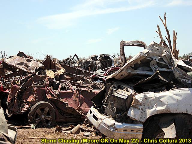
Moore, Oklahoma tornado from May 20, 2013 (picture taken on May 22) - Vehicle remains (once inside garages of disintegrated homes) piled in a field.
Posted: May 22, 2013, 10:28 PM
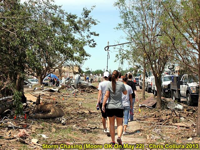
Chris Collura added a new photo.
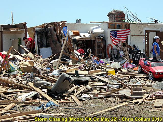
Moore, Oklahoma tornado from May 20, 2013 (picture taken on May 22) - Destroyed residence and people going through rubble.
Posted: May 22, 2013, 10:28 PM
Chris Collura added a new photo.

Moore, Oklahoma tornado from May 20, 2013 (picture taken on May 22) - Overturned vehicle in front of destroyed medical offices.
Posted: May 22, 2013, 10:06 PM
Chris Collura added a new photo.
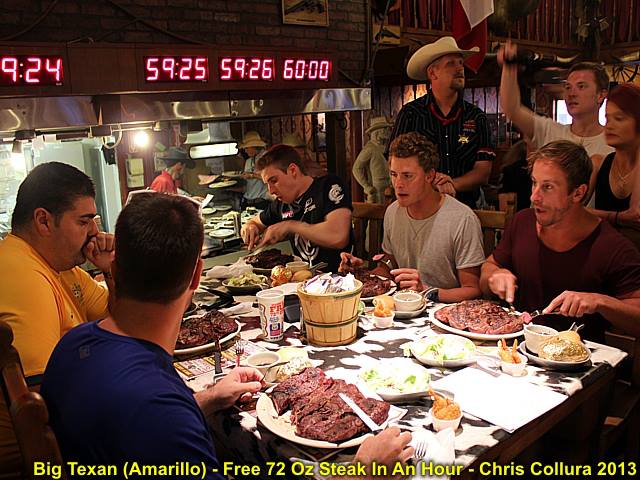
Big Texan steakhouse (Amarillo, Texas) ... Eat a 72 Oz steak with two sides and rolls and a drink in an hour or less ... And it's free! Many try, and many fail.
Posted: May 22, 2013, 10:04 PM
Chris Collura added a new photo.

Rattlesnake on display at the Big Texan steakhouse in Amarillo, Texas.
Posted: May 22, 2013, 2:25 PM
Chris Collura updated his status.
Headed west on I 40 to Amarillo and big Texan steakhouse! Sobering visiting Moore earlier - Insane damage and very sad there.
Posted: May 22, 2013, 1:06 PM

Ground zero ... Moore, Oklahoma - God bless all victims.
Posted: May 22, 2013, 6:24 AM
Chris Collura added a new photo.
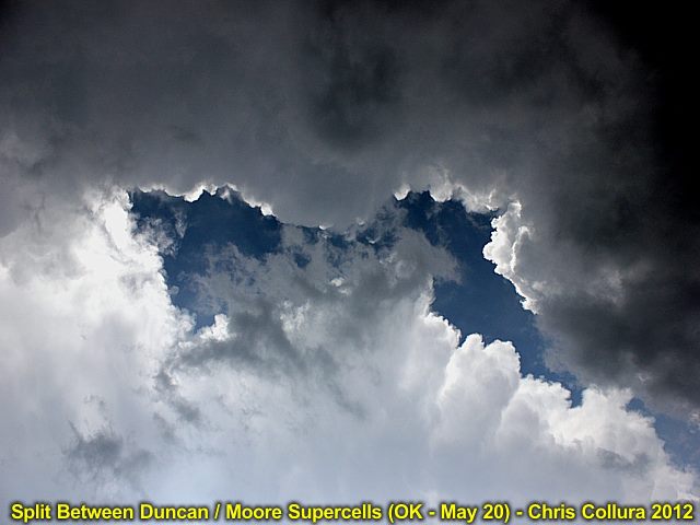
Split between two anvils ... One was the Duncan, Oklahoma supercell and the other the devastating Moore, Oklahoma storm on May 20, 2013.
Posted: May 22, 2013, 5:48 AM
Chris Collura updated his status.
May 22 (today) should be an off day to re-position back north and west towards TX / OK Panhandles (most likely near Amarillo) by tonight ... May 23 (Tomorrow) should be a more isolated severe chase day with possible supercells and tornadoes in great chase terrain.
Posted: May 22, 2013, 5:45 AM
Chris Collura added a new photo.

Scores for 05/21 ... COLD air = 267, tornadoes = 0. Jackets KILL supercells!
Posted: May 22, 2013, 5:37 AM
Chris Collura added a new photo.
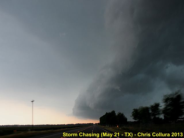
Gust front from tail-end storm 25 miles or so south of Waco, Texas on May 21, 2013.
Posted: May 21, 2013, 7:45 PM
Chris Collura updated his status.
The state of Texas was EXTREMELY lucky today (5/21) due to surging outflow that prevented supercells with long-track tornadoes!
Posted: May 21, 2013, 6:31 PM
Chris Collura updated his status.
Wrapped up today's chase. Not much .. Saw some incredible bumper-to-bumper action in Dallas :-)
Posted: May 21, 2013, 3:17 PM
Chris Collura updated his status.
In Waco Texas ... Feeling this will be the most overhyped SPC setup in 10 years...
Posted: May 21, 2013, 1:25 PM
Chris Collura updated his status.
Just passed Dallas now ... Worst traffic jam I EVER seen on my life. My bald spot size just doubled...
Posted: May 21, 2013, 1:01 PM
Storm chaser 'flypaper' :-)
Posted: May 21, 2013, 12:44 PM
Chris Collura updated his status.
Sitting dead in traffic north of Dallas under outflow cold junk that not only caused the traffic but probably will cause NO supercells (let alone tornadoes) today. Boundary is now 30 mrs east of me!!! How the eff did that happen?
Posted: May 21, 2013, 12:38 PM
Chris Collura updated his status.
Stay AWAY from I 820 / TX 183 north of Dallas / Fort Worth - it's a 'flypaper' for storm chasers (construction everywhere)!
Posted: May 21, 2013, 10:45 AM
Chris Collura updated his status.
Here we go again - Moderate risk for the Dallas, TX area and points eastward. Please let the tornadoes / hail and wind MISS the towns / cities today! Stay safe out there everyone, chasing or not...
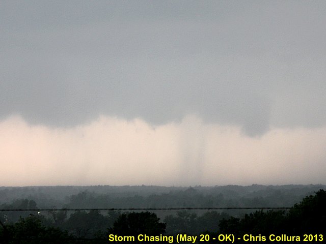
Posted: May 20, 2013, 7:50 PM
Chris Collura added a new photo.
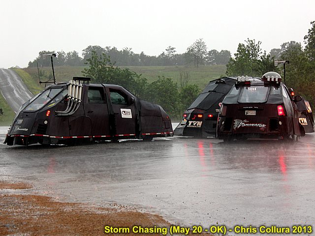
There is indeed now MORE than ONE 'Dominator' - May 20, 2013.
Posted: May 20, 2013, 7:50 PM
Chris Collura added a new photo.

Monsters always start 'small' ... This is the initiation of the Moore, OK storm on May 20.
Posted: May 20, 2013, 7:50 PM
Chris Collura added a new photo.
Some tornadic activity on the SW side of the Duncan supercell (the cell SW of the Moore, OK storm) on May 20.
Posted: May 20, 2013, 7:50 PM
Chris Collura added a new photo.
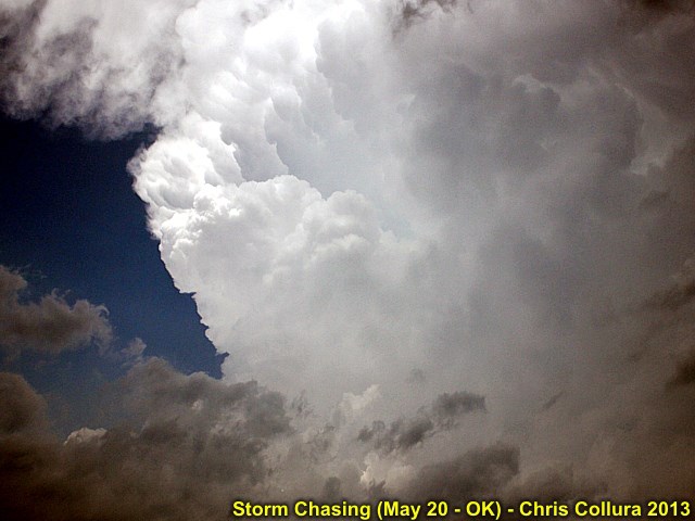
This is the updraft of the Moore, OK tornadic storm about 10 minutes before it destroyed the town on May 20, 2013.
Posted: May 20, 2013, 7:45 PM
Chris Collura updated his status.
I am note sure about what to say about today (May 20) ... Just God's blessing and prayers to those in Moore, Oklahoma. We all ask WHY "kids"? Why "anyone"? No - No one deserves to die LIKE that.
Remember one thing - You had a bad day at work - You are LUCKY enough to have a job. You complain about gas - You HAVE a car. Yes - Today illustrated how sucky life can be for some folks. Life is indeed precious - And delicate too!
I was on the Moore storm during its early stages. I did not chase it into the city because of the issues with traffic, lights, etc ... So I remained SW in the open country on the second supercell to its south, which produced a brief tornado.
After seeing what happend in Moore, with the school and all that, I just wanted to go home early - But remained strong and should continue my chase trip till June 2. I was actually chasing with tears in my eyes today. Looking at the southern supercell, seeing the gust front, striations, RFD - Then crying (thinking about Moore).
These storms are like the movie 'aliens' - Pure monsters. I just saw the little 'egg' of the Moore monster today :-(
Posted: May 20, 2013, 4:34 PM
Chris Collura updated his status.
Extremely grim day for Moore Oklahoma ... This is very sad.
Posted: May 20, 2013, 4:04 PM
Chris Collura updated his status.
PISSED as a mother fucker today ... Picked the supercell south of the Moore one. So sick I feel like going home ;(
Posted: May 20, 2013, 6:34 AM
Chris Collura updated his status.
Here we go ... Day 3 for me - Southern to SW OK to start out - Another big severe weather day on tap (5/20)!
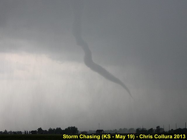
Posted: May 19, 2013, 7:56 PM
Chris Collura added a new photo.

Tornado number one of the supercell south of Wichita, Kansas on May 19.
Posted: May 19, 2013, 7:56 PM
Chris Collura added a new photo.
Closeup of the first tornado associated with the Wichita storm on may 19.
Posted: May 19, 2013, 7:56 PM
Chris Collura added a new photo.
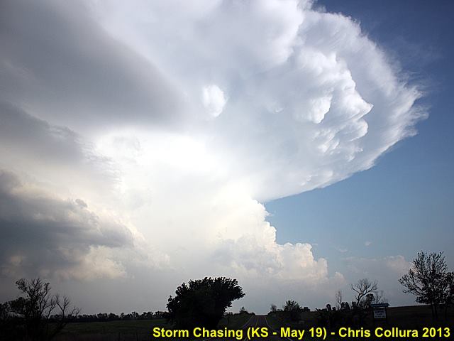
One of many intense supercell storms near Northern Oklahoma on May 19.
Posted: May 19, 2013, 7:56 PM
Chris Collura added a new photo.
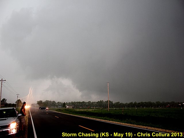
Developing LARGE tornado number 2 (the left edge of the tornado is just over the roadway. Very rapid rotation - Multi vortex tornado that hit Wichita on May 19.
Posted: May 19, 2013, 4:06 PM
Chris Collura updated his status.
Got both tornadoes today on the Wichita monster supercell!
Posted: May 18, 2013, 10:15 PM
Chris Collura added a new photo.
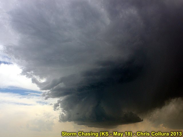
LP storm near Burlington, CO (May 18).
Posted: May 18, 2013, 10:15 PM
Chris Collura added a new photo.
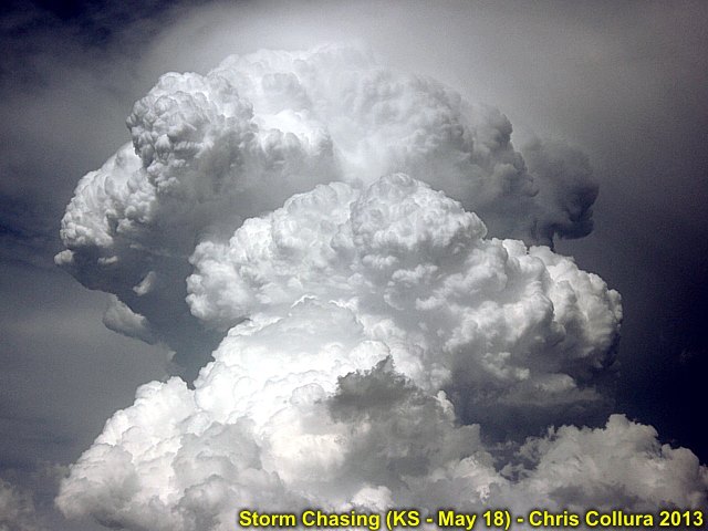
Explosive supercell development (Kansas / May 18).
Posted: May 18, 2013, 10:15 PM
Chris Collura added a new photo.

Tornado on northern supercell SW of Hays (May 18).
Posted: May 18, 2013, 10:15 PM
Chris Collura added a new photo.
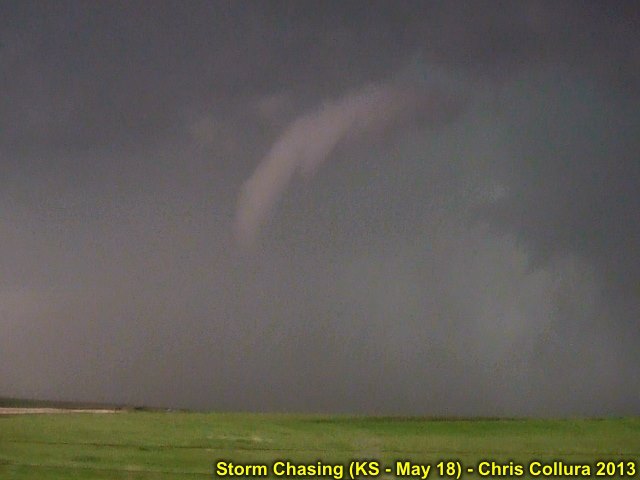
Tornado on northern supercell SW of Hays (May 18).
Posted: May 18, 2013, 7:59 PM
Chris Collura updated his status.
Spending the night in Hays, Kansas after a long chase right from Denver to northern tornadic storm ... No way I could have made the southern storm. Still saw two small tornadoes ... Pics coming soon.
Posted: May 18, 2013, 5:06 AM
Chris Collura updated his status.
Getting on plane for Denver now ... Then off to W / SW Kansas by afternoon ... Updates coming soon!
Posted: May 17, 2013, 2:47 PM
Chris Collura updated his status.
Now leaving work this Friday and headed to Denver on a first non-stop flight out to land in Denver at 11:20 AM (MDT) on 5/18 ... I am soooo glad I got this schedule a week ago! Seeing a 45 percent and moderate risk makes me think of 2 things that can happen...
1). I see lots of storms, tornadoes, and have a great first day from near Colby, Kansas and northwards after driving a few hours.
2). I can destroy my rental vehicle in gigantic hail the FIRST day out ;-) ... Number 1's a bit gentler...
Posted: May 17, 2013, 10:18 AM
Chris Collura updated his status.
Why do "these scumbags" always jack up gas prices just before we all go stormchasing? Oh, I know, because "something" happened 10,000 miles away...
Posted: May 15, 2013, 2:21 PM
Chris Collura updated his status.
Saturday 5/18 seems to be the start of a multi-day severe weather event across the central USA. I like the areas nudged back west, making S Central NE and N Kansas easily reached from Denver as I arrive that morning.
After that, the "system" will be followed eastward, maybe as far as Illinois / Iowa by Monday (5/20).
Posted: May 15, 2013, 6:22 AM
Chris Collura added a new photo.
NO ... Not real ... I was just playing with some Photoshop stuff. Skydive next to a beautiful supercell storm from above the anvil (FL 650+) high over the American Great Plains!
Posted: May 14, 2013, 7:19 AM
Chris Collura updated his status.
Jeez ... I'll be LANDING in Denver, CO at about 11:20 AM on 5/18 (Sat) ... Grab the car and run-run-run to I-76 as fast as possible and into Nebraska on I-80 - And blast HARD to the East! Chasing waits for no man...
Posted: May 12, 2013, 12:17 PM
Chris Collura added a new photo.
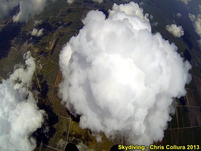
View looking down just after jumping and pulling chute at 12,000+ feet. Nice TCU flield BELOW me (!) - May 11, 2013.
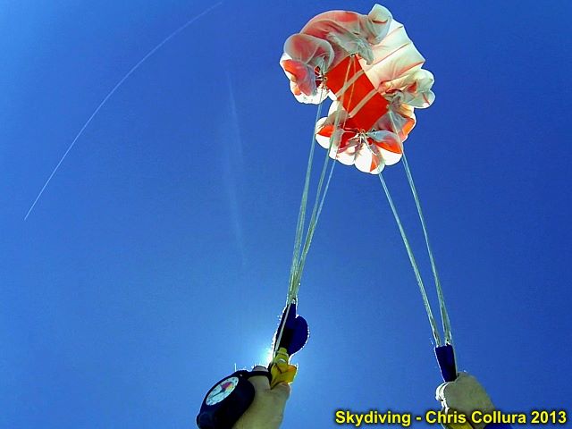
Posted: May 12, 2013, 12:17 PM
Chris Collura added a new photo.
Opening chute just after exit at 12,500' on May 11, 2013 over Clewiston, FL.
Posted: May 12, 2013, 12:17 PM
Chris Collura added a new photo.
Hanging out in the air at 10,000+ feet - It's quite a ways down! May 11, 2013.
Posted: May 11, 2013, 8:44 PM
Chris Collura likes a video on YouTube.
YouTubeAlien deleted scene: Alien attacks Lambert - good qualityhttp://www.youtube.com/watch?v=eR5jYeIMBKk
Posted: May 10, 2013, 6:04 PM
Chris Collura updated his status.
Just got the car rental and air ticket for May 18 to June 2 chase trip - Using SWA points. Totally refundable incase the dreaded 5-letter R word decides to jack with us. $265 for car and air WITH tax into Denver non-stop. Not bad ... Until I trash the rental in hail (?)!
Posted: May 9, 2013, 5:19 PM
Chris Collura added a new photo.

Developing mini supercell storm (updraft structure) near Broward / Miami-Dade county border, FL on May 9.
Posted: May 9, 2013, 5:19 PM
Chris Collura added a new photo.
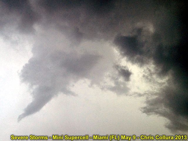
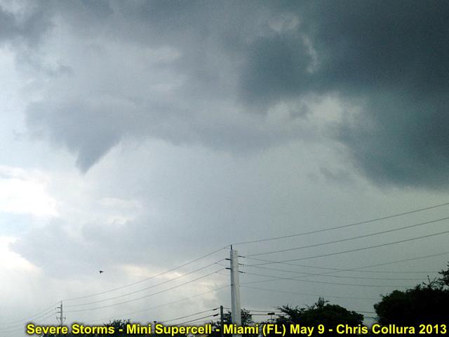
Anticyclonic (clockwise) funnel over Hialeah (Miami-Dade county), FL on May 9.
Posted: May 9, 2013, 5:19 PM
Chris Collura added a new photo.

Severe thunderstorm over Miami-Dade county, FL - May 9.
Posted: May 9, 2013, 5:19 PM
Chris Collura added a new photo.

Severe thunderstorm (close up of updraft) over Miami-Dade county, FL - May 9.
Posted: May 9, 2013, 5:19 PM
Chris Collura added a new photo.
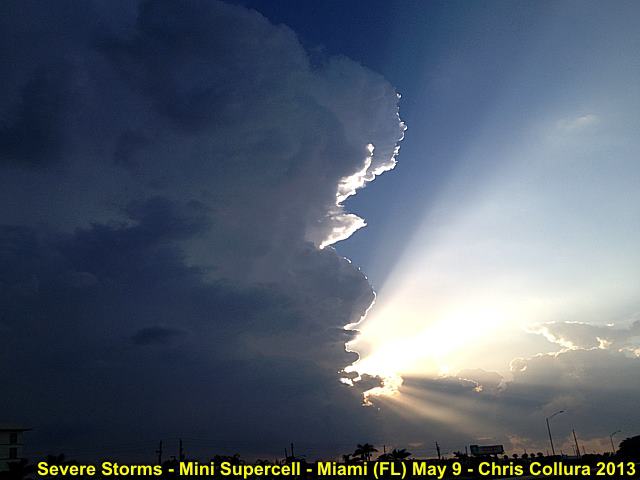
Beautiful updraft of severe thunderstorm over Miami-Dade county, FL - May 9.
Posted: May 9, 2013, 5:19 PM
Chris Collura added a new photo.
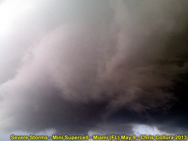
Rotating area of supercell thunderstorm over Miami-Dade county, FL - May 9.
Posted: May 9, 2013, 5:19 PM
Chris Collura added a new photo.

Anticyclonic (clockwise) rotation over Hialeah (Miami-Dade county), FL on May 9.
Posted: May 9, 2013, 5:19 PM
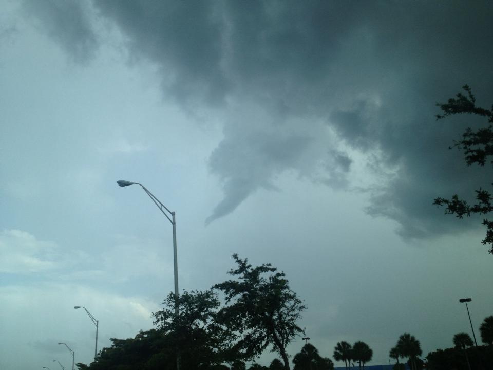
Chris Collura added a new photo.
Developing anticyclonic (clockwise) funnel over Hialeah (Miami-Dade county), FL on May 9.
Posted: May 9, 2013, 3:18 PM
Right now in Miami Florida!
Posted: May 9, 2013, 12:43 PM
Chris Collura added a new photo.
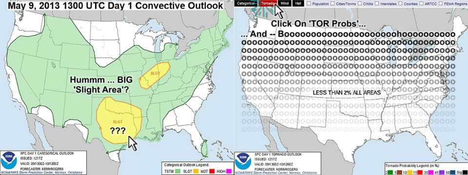
Meh 2013? A big slight and a hatched hail ... Committed to a chase? Then move the mouse over the SPC "Tornado" button and - Uh - Well, Meh (not "May")...
Posted: May 9, 2013, 12:39 PM
Chris Collura updated his status.
Looks like Wed 5/8 was the day this week to be chasing in central USA. Today 5/9 is more of a hail / wind (or maybe a funnel as per Dan Daniel Shaw). Models slowly showing a more stormy late May (hopefully will verify).
Posted: May 9, 2013, 12:38 PM
Chris Collura added a new photo.
Added 5/8 based on Day 2 - Moved to this album. Long and lengthy SPC outlook(s) ... But still cannot find a 'tornado' in any of them yet :(
Posted: May 8, 2013, 5:26 PM
Chris Collura updated his status.
The twin thin funnels you see posted are indeed real shots ... Very pretty!
Happy something came out of this 'iffy' central USA setup after all!
Posted: May 8, 2013, 2:42 PM
Chris Collura updated his status.
Surprised to see the last-minute SPC wording and 5% tor probabilities in OK.
Looks like some folks will see something there after all!
If anyone catches tornadoes, then the next setup (in 2 weeks or so) will be a bit more "encouraging" for me to buy the expensive plane tickets...
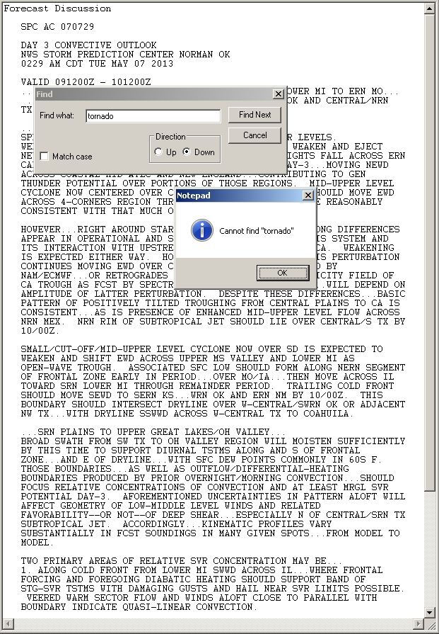
Posted: May 7, 2013, 5:34 PM
Chris Collura updated his status.
SPC: GIVEN EXPECTED MODEST MOISTURE RETURN AND VERTICAL SHEAR...OVERALL TORNADO THREAT DOES NOT APPEAR PARTICULARLY ROBUST...BUT A COUPLE TORNADOES CANNOT BE RULED OUT.
YOUR'E A NICE GUY BUT I AM SORRY, I DO NOT THINK WE ARE A GOOD MATCH. BUT I DO LIKE OLDER MEN WITH MONEY (LET ME KNOW).
Posted: May 7, 2013, 6:47 AM
Chris Collura updated his status.
Tempted to just get on a plane and head to OK / KS / TX to chase this week. Job wise, I can get off work and go - But is it really WORTH it?
1). Dropping nearly $1000 for maybe a 5% tornado prob at best on Wednesday? Will it be over-rated and over hyped?
2). Airfares alone are from $420 to $750 r/t - Still high, and you have to leave at 6 AM cuz I'm in Fort Lauderdale and these effing vacationers are too freaking lazy to wake up then (the $750 ticket is leaving after work, 7 PM or so)!
3). If I do go, the 5% will be dropped to 2% once Collura is in the area :-(
4). Cold front surges through the area by early Friday - Flushing it all away (Swoooosh-Slerrr-tinkle-tunk-ooouup - toilet flushing sound effect inserted here).
5). I really wanna just save my gambling money for better prospects and / or see if this little setup REALLY does anything first ... Then I'll be a 'believer'.
6). Next chase opp after that - Only 2 weeks. Can't wait.
Posted: May 4, 2013, 9:47 PM
Chris Collura likes a video on YouTube.
YouTubeIntellivision Space Armada - Full game from 1st wave to 13th wavehttp://www.youtube.com/watch?v=RxTCyfWwwgg
Posted: May 4, 2013, 5:00 PM
Chris Collura added a new photo.
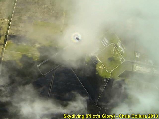
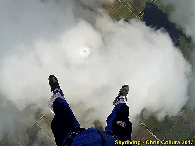
My shadow (and Pilot's glory halo) on clouds just below me. May 4, 2013.
Posted: May 4, 2013, 5:00 PM
Chris Collura added a new photo.

Exiting over Clewiston, FL. May 4, 2013.
Posted: May 4, 2013, 11:35 AM
Chris Collura added a new photo.
Love bug season ... Windshield whore-house disaster!
Posted: May 3, 2013, 9:36 PM
Chris Collura likes a video on YouTube.
YouTubeFarnsworth Fusorhttp://www.youtube.com/watch?v=7iSDnANGAFs
Posted: May 2, 2013, 6:35 PM
Chris Collura updated his status.
Got some killer flooding footage down here in Hollywood, FL ... Had my iPhone out the driver's door in it's otter case, down low, shooting 30+ seconds of severe street flooding - Or so I thought.
Theres a little button (slider) with a still / video icon on it ... Too much on my mind, didn't hit that, so I got a still image when I (thought) I pressed record, and another 30 seconds later when I (thought) I hit stop.
Dumbass ey?
At least it wasn't a tornado ripping the roof off my office ;(
Generated by Sky-Chaser Chris Collura on Wednesday, March 24, 2021 at 6:19 PM UTC-07:00
HTML File "indx1305.htm" (Facebook) - Developed By Chris Collura
To Return To The HOME Page Of This Site Click The "INDEX.HTM" Link Here!