
Facebook Timeline Posts For October 2011
(Posts And Comments During October 2011 For Sky-Chaser Chris Collura On Facebook)
[ 2011-NOV ] [ BACK TO INDEX ] [ 2011-SEP ]
Posts And Comments For October 2011
Posted: Oct 30, 2011, 5:17 PM

Happy Halloween!
Posted: Oct 30, 2011, 10:28 AM
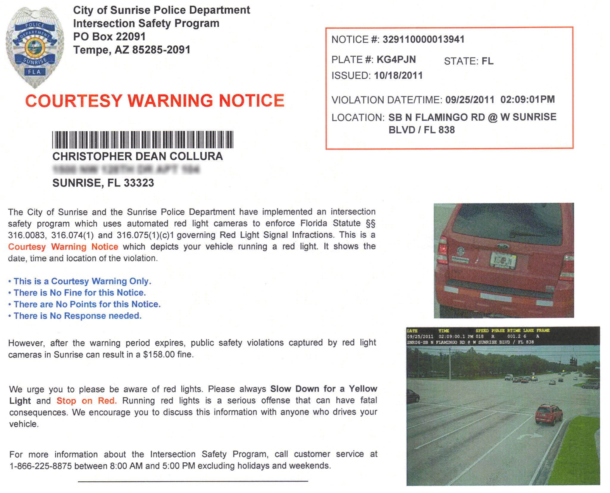
Be careful as traffic cameras are watching - Don't even slow down for a red light / right turn - STOP completely. Big brother is WATCHING YOU!
Posted: Oct 29, 2011, 5:36 PM
Chris Collura updated his status.
Cold front just passed through. No skydiving today, so I bought an iPad2 ;-)
Posted: Oct 29, 2011, 5:35 PM
Chris Collura commented on Stephen Sponsler's post.
Posted: Oct 28, 2011, 5:35 PM
Chris Collura commented on Michael Malinconico's post.
Posted: Oct 28, 2011, 5:19 PM
Chris Collura commented on Michael Malinconico's post.
Posted: Oct 28, 2011, 5:18 PM
Chris Collura commented on Michael Malinconico's post.
Posted: Oct 28, 2011, 5:11 PM
Chris Collura commented on Michael Malinconico's post.
Posted: Oct 28, 2011, 5:10 PM
Chris Collura posted in Hurricaneconnect.
Posted: Oct 28, 2011, 5:09 PM
Chris Collura added a new photo.
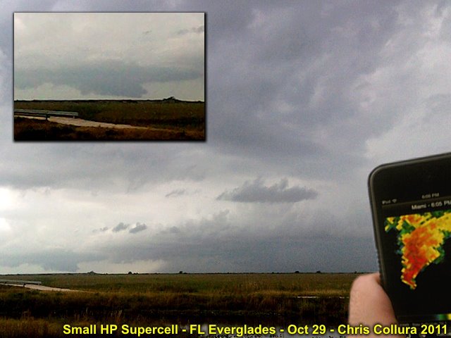
Small supercell storm experienced in Miami Dade county during the early evening of Oct 29, 2011 on the leading edge of the remnants of Rina (upper shear). This storm produced large wall cloud and some small funnels over the everglades.
Posted: Oct 28, 2011, 3:28 PM
Chris Collura posted in Hurricaneconnect.
Posted: Oct 26, 2011, 10:32 AM
Chris Collura updated his status.
Rina weakened SIGNIFICANTLY between the 10:00 AM and 11:45 AM time-frames with a pressure rise of nearly 20 mb (now 982) and winds down from 110 to 85 MPH in a measly small core. Now thinking on using airfare for Denver in February. 2011 has been a really rotton year for hurricanes.
Posted: Oct 25, 2011, 8:19 PM
Chris Collura updated his status.
Watching Rina ... Anyone chasing it?
Posted: Oct 24, 2011, 12:08 PM
Chris Collura updated his status.
Watching hurricane Rina in SW Caribbean. Maybe a Yucatan chase or will it affect S FL (too early to tell) by late week. Probably the last real viable hurricane chase opp of 2011.
Posted: Oct 24, 2011, 6:03 AM
Chris Collura wrote on Mona Lowenthal Krimsky's timeline.
Hi there ... Happy birthday!
Posted: Oct 21, 2011, 8:26 AM
Chris Collura added a new photo.
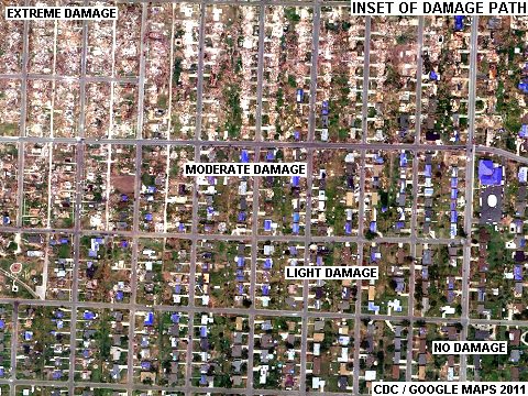
Closeup of Joplin, MO tornado (May 22) damage path showing intense gradient from total damage to no damage and damaged homes (blue tarps on roofs) in between.
Posted: Oct 21, 2011, 8:26 AM
Chris Collura added a new photo.
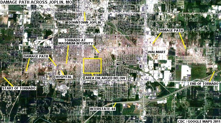
Joplin, MO tornado (May 22) damage path seen from aerial / satellite.
Posted: Oct 20, 2011, 6:18 AM
Chris Collura updated his status.
Cool as we head into the middle of this week. Lucky too as the EF-2 tornado the other night came a mere block of my apartment in Sunrise.
Posted: Oct 18, 2011, 7:40 PM
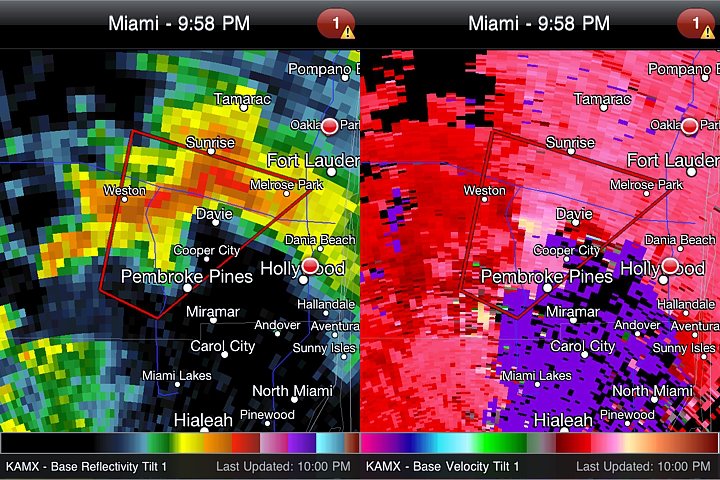
Large wall cloud / possible tornado (or at least a large funnel) was observed at about 9:45 PM west of I-75 near Pembroke Pines, FL. This image is the radar grab from the small tornadic supercell storm as it passed west of Davie and near Sunrise at about 9:55 PM. Power flashes noted at that time...
Posted: Oct 18, 2011, 11:17 AM
Chris Collura updated his status.
Subtropical system currently (as of late Tuesday) passing to the west of S Florida with an enhanced T-Storm threat (tornado probability 5%).
Posted: Oct 17, 2011, 4:41 PM
Chris Collura commented on Marcellus Stokes's post.
Posted: Oct 17, 2011, 4:40 PM
Chris Collura commented on Michael Malinconico's post.
Posted: Oct 17, 2011, 4:39 PM
Chris Collura commented on Marcellus Stokes's post.
Posted: Oct 17, 2011, 4:38 PM
Chris Collura commented on Marcellus Stokes's post.
Posted: Oct 17, 2011, 4:11 PM
Chris Collura updated his status.
Monday ... Oh and what a rainy dreary one here in S FL if that. An ode to '09 ... The Atlantic tropics are DONE - I'm convinced of that, and finally accepting that. The "energy" can be released rapidly (such as a big "Wilma like" hurricane) or slowly, as in this highly-sheared environment NW of Cuba. Happy I chased Irene, kicking myself I didn't go for Jova in MX. Got short ahircut today (Monday) and flu shot after work. Happy this "system" over FL didn't come 2 days earlier.
Posted: Oct 17, 2011, 10:42 AM
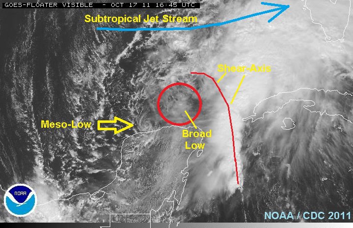
Interesting "micro-cyclone" (mesolow type feature) on the SW side of the broad area of low pressure north of the Yucatan (developing subtropical system). Very distinct on visible satellite.
Posted: Oct 15, 2011, 4:54 PM
Chris Collura updated his status.
Just finished skydiving and visiting my mom this weekend. Watching possible tropical development near the Yucatan the next few days (but I'm not holding my breath).
Posted: Oct 13, 2011, 5:13 PM
Chris Collura wrote on Josh Morgerman's timeline.
Hope all you guys are OK out there ... You are in the "ionization blackout" obviously ;-)
Posted: Oct 13, 2011, 10:47 AM
Chris Collura commented on Jim Leonard's post.
Posted: Oct 10, 2011, 7:35 AM
Chris Collura updated his status.
Back to work this week. Hurricane "Insanity" is now in the Pacific side, with Hurricane Jova expected to slam into Mexico Tuesday night (probably near Manzanillo). Wish I was there (I'm at work) ;-(
Posted: Oct 9, 2011, 5:34 PM
Chris Collura added a new photo.

Posted: Oct 9, 2011, 11:07 AM
http://www.youtube.com/watch?v=HXz352TkZVM&feature=share
Posted: Oct 8, 2011, 5:37 PM
Chris Collura added a new photo.

Posted: Oct 8, 2011, 5:37 PM
Chris Collura added a new photo.

Posted: Oct 8, 2011, 5:37 PM
Chris Collura added a new photo.
Posted: Oct 8, 2011, 5:37 PM
Chris Collura added a new photo.

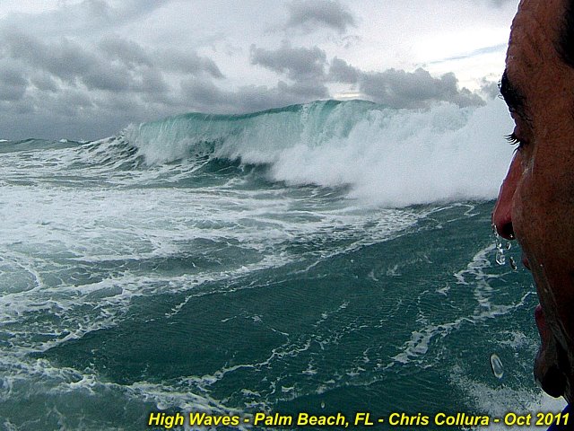
Posted: Oct 8, 2011, 5:35 PM

Strong pressure gradient between developing subtropical low and Canadian High is producing near gale-forced winds along the SE Florida Coast. It's so much fun to play in the 8-12 foot waves off Boynton Beach with my SeaDoo watercraft!
Posted: Oct 7, 2011, 6:26 AM
Chris Collura updated his status.
Should be a windy and wet weekend (especially towards the latter part) for much of eastern FL as a sub-tropical low tries to develop. Meanwhile hurricane Philippe "follows the recurve-brick road" staying at sea and bothering no one.
Posted: Oct 7, 2011, 6:22 AM
Chris Collura commented on Brittany Banasz's post.
Posted: Oct 6, 2011, 5:59 AM
Chris Collura commented on Stephen Sponsler's post.
Posted: Oct 5, 2011, 4:46 PM
Chris Collura commented on Stephen Sponsler's post.
Posted: Oct 3, 2011, 5:16 PM

Thought this number was kind of funny on a travel site ;-)Yeah, not cheap, but why charge THAT price (the Devil's number)?
Posted: Oct 1, 2011, 5:11 PM
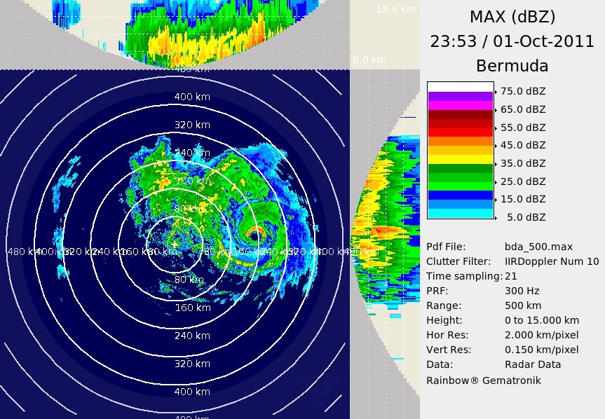
Hurricane Ophelia is "safely" passing well to the east of Bermuda this (10/1) evening with 135 MPH winds (Category 4). Nothing going on at the island due to it being too far west of the storm. Very impressive on the BDA radar, though. I did not go there and chase it because I knew it was going to miss Bermuda (pass east of there)!
Generated by Sky-Chaser Chris Collura on Wednesday, March 24, 2021 at 6:19 PM UTC-07:00
HTML File "indx1110.htm" (Facebook) - Developed By Chris Collura
To Return To The HOME Page Of This Site Click The "INDEX.HTM" Link Here!