
| This area shows pictures taken from the observations of tropical storm Bonnie in extreme south Florida during the morning of July 23, 2010. This tropical system developed from a tropical wave in the southeastern Bahamas and intensified to a weak tropical storm on July 22. It remained a disorganized tropical storm, with 40-MPH sustained winds, until it reach south Florida in Miami-Dade county, and weakened over land on July 23. After crossing south Florida, tropical storm Bonnie weakened to a tropical depression and moved into the northern Gulf of Mexico by July 24. The storm weakened to a remnant low and dissipated near Louisiana without much effect to the oil spill nor any second landfall. My chase of this system was a solo and local chase, primarily from Miami Beach and southward into Kendall. It was a very frustrating chase due to the combination of extreme rush-hour traffic and accidents, taking 2 hours to go from Sunrise, FL in Broward County to Miami Beach in Miami-Dade county, a mere distance of about 20 miles. Conditions observed were strong winds, heavy rains, as well as the partly cloudy circulation center (with light winds) of the storm as it made landfall at about 11 AM EDT south of Miami. The chase was wrapped up as the weaker side of the storm (SE side) came ashore. This was the first tropical cyclone intercept of 2010. |
| CHASER NAME | HOME CITY | CALLSIGN | OCCUPATION |
| CHRIS COLLURA | SUNRISE, FL | KG4PJN | COMPUTER ANALYST |
|
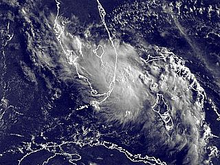
This is a visible satellite image of tropical storm Bonnie making landfall in extreme south Florida south of Miami during the late morning of July 23. The storm is being sheared by an upper-level low pressure area to the west (left side of the image) with a strong SE wind present in the upper levels (drawing the upper clouds from Bonnie to the NW). The storm center is near the SE tip of mainland South Florida with most of the heavy convection north and west of that area. |

|
Here is a view (looking southward on I-95) of downtown Miami, Florida just before tropical storm Bonnie was about to make landfall about 15 to 20 miles to the south. Heavy rains, bad drivers, accidents, and 40-MPH winds made driving in this storm a nightmare. |

|
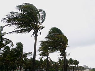
Conditions at South Beach in Miami-Dade county were 40-MPH winds, heavy rains, and higher gusts to around 50-MPH. The ocean waves were in the 5-7 foot range with tides a foot or so above normal. |
|
Palm trees bending in the stiff winds off the ocean in South Beach during the passage of a convective band. |
|
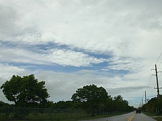
Here is a view of the sky near the circulation center of tropical storm Bonnie as it made landfall south of Miami, Florida. Light winds and partly cloudy skies, with sunshine and blue patches peeking through overhead, lasted for about a half hour as the center of Bonnie passed. Official pressure at landfall in Florida from the NHC was 1008 MB at landfall, so not a very deep low. |
|
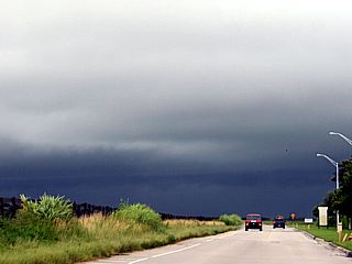
This is the view looking west from south of Kendall in Miami-Dade county from within the diffuse center of Bonnie and towards the heavy thunderstorm convection wrapping around the western side of the tropical storm. This is associated with the main "convective chimney" of the tropical cyclone, and quickly weakened once over land and cut-off from the warm ocean. |
HTML File "bonn10.htm" - Developed By Chris Collura

My Contact Information Is Given In The Graphic Above
To Prevent SPAM And Abuse - The EMAIL Banner Above Only Links To My Information Page
For My EMAIL - You Will Need To Take It Down And Enter It In Your EMAIL Package
To Return To The HOME Page Of This Site Click The "INDEX.HTM" Link Here!