
| This area shows pictures taken from the observations of tropical storm Bonnie in the Florida Panhandle and Big-Bend area. This tropical system showed some signs of becoming a hurricane on the morning of August 12 but never was able to pull through. The storm came ashore in the Florida big-bend area as a minimal tropical system with 40 MPH winds. Lowest pressure measured by our equipment was 1002 MB as part of the broad and diffuse center was neared. The chase was to Panama City, Florida where myself and Jeff Gammons with the former "Weathervine" storm intercept team waited for the storm. On returning, we met with Jason Foster near Tallahassee who drove in from Maryland the same day. The chase trip on my part logged about 1057 total miles! This chase was to be a "warm-up" chase for what was to be had with hurricane Charley the following days! |
| CHASER NAME | HOME CITY | CALLSIGN | OCCUPATION |
| CHRIS COLLURA | MIRAMAR, FL | KG4PJN | COMPUTER ANALYST |
| JASON FOSTER | BALTIMORE, MD | N3PRZ | ARCHITECT |
| JEFF GAMMONS | WPB, FL | KG4PGA | PHOTOGRAPHER |
|
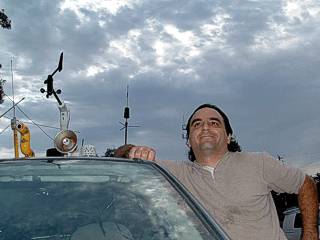
Here is a picture of myself in Panama City, Florida after preparing the chase vehicle, a 2004 Ford Focus station wagon, for tropical storm Bonnie. We are at a Comfort Inn motel about 1 mile from Panama City beach. |
|
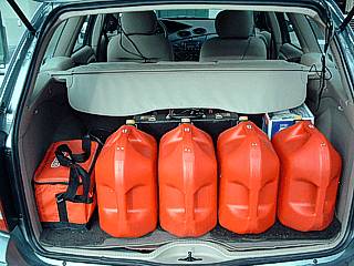
Anticipating tropical storm Bonnie then hurricane Charley the following day, four five-gallon gas containers were also carried along for any fuel issues. |
|
Moderate to heavy rains and 30 MPH winds were pretty much all that came from tropical storm Bonnie which weakened rapidly before landfall south of Appelacicola, Florida. Rainfall was about five inches, with heavy thunderstorms during the morning of August 11. |
|
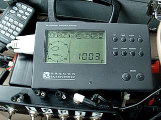
As the poorly organized and broad center of Bonnie came ashore, a reading of 1003 millibars was recorded south and east of Tallahassee, Florida along Interstate 10. Official pressure from the NHC was 1002 MB. |
|
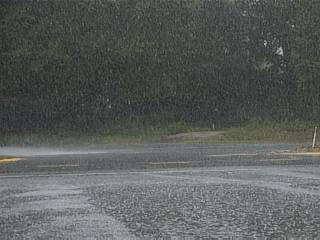
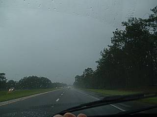
This picture shows heavy and steady rains encountered with Bonnie while eastbound on Interstate 10 east of Tallahassee. |
|
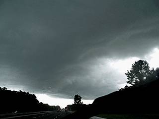
One of the most ominous storms developed on the right-front side of weakening tropical storm Bonnie, where a tornado watch was in effect. Here we are looking south at the updraft base of a developing supercell thunderstorm northwest of Gainesville, Florida along Intertate 75. It is this storm, that was to move to the northeast to produce tornadoes in Jacksonville an hour or so later. Note the "horseshoe updraft" and well-pronounced RFD (Rear Flank Downdraft) slot. |
HTML File "bonn04.htm" - Developed By Chris Collura

My Contact Information Is Given In The Graphic Above
To Prevent SPAM And Abuse - The EMAIL Banner Above Only Links To My Information Page
For My EMAIL - You Will Need To Take It Down And Enter It In Your EMAIL Package
To Return To The HOME Page Of This Site Click The "INDEX.HTM" Link Here!