
| This is my picture based log by chronological order of some select pictures of early storm chases and observations conducted up to the year 1989. This log is separate from any storm chase expeditions to the US plains or Midwest, and does NOT include tropical cyclone interceptions. These other chase logs are available as separate logs from the main storm chasing section. This log is for most "home" chases in the state of Florida or for other miscellaneous storm or coastal observations. Keep in mind that this log is scientific evidence and portrays my on-going storm chasing research. It has been placed on this page for easy reference and meteorological interests. Please do not plagiorize or copy this document to other sites for distribution. Feel free to browse through my main storm chasing picture section. Note - This page may take a while to load on some SLOWER connections! |
TABLE OF CONTENTS - CLICK TO GO TO PAGE
|
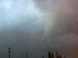
An F0 to F1 tornado touches down in Pompano Beach, Florida on January 5, 1987. This is my first tornado picture showing the funnel on the rear side of an HP supercell storm. Note the clear slot in the upper-left side of this picture associated with the RFD. This tornado blew down a light pole and uprooted some trees. |
|
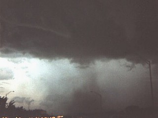
A tornado crosses Interstate 95 in Dania, Florida on July 7 1987. The tornado is on the southwest side of a classic supercell over Fort Lauderdale, Florida. The tornado destroyed trees and a few homes. The tornado is an F1 on a scale from F0 to F5. |
|
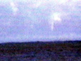
A waterspout or "steam vortex" develops over the warm Gulf Stream waters off Palm Beach, Florida on December 25, 1989. This was a record cold wave for Florida with snowfall occurring as far south as Orlando, Florida. When this picture was taken, it was 28 degrees. When the frigid air moves from the NW over the warmer 80 degree Gulf Stream a few miles off Palm Beach, a steep lapse rate is set up in the first thousand feet or so above the sea surface. Steam fog and rapidly rising thermals in this layer spin up in the strong wind shear and produce the steam funnel waterspout in this picture. Note that even the cloud base is lowered and rotating just above the waterspout. The cold cumulus clouds were no more than 3,000 feet high. Ocean waves also were NE swells as high as 15 feet. |

|
A severe thunderstorm cluster undergoes multicell to supercell evolution over Northport, New York in July 1986. The view here is to the north. The storm had hail up to 2.5 inches. Note the rock-hard appearance to the cloud. |
|
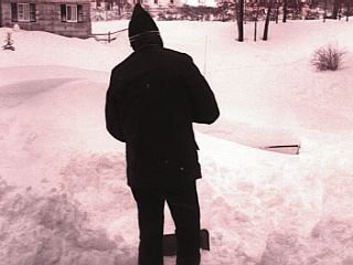
The infamous blizzard of 1978 experienced first hand as I was a child in Ronkonkoma, New York on Long Island. This is a picture of my father shoveling the heavy snow from the front door, just so we can get out. The driveway was another story, the 1977 Cadillac is completely covered except for its rear bumper in the right of the picture. This storm brought 90 MPH winds to New England and snow totals of 3 to 4 feet. These extratropical storms can have winds as strong as their distant tropical cousins, hurricanes. |
|
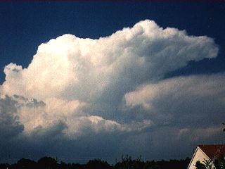
A thunderstorm anvil fires just north of Broward County, Florida in March of 1989. This is the typical "anvil" cumulonimbus cloud. |
|
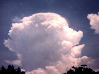
A single cell but very strong to severe thunderstorm fires in Broward County, Florida in June of 1987. The storm here is a single cell storm, developing in a low shear but high CAPE atmosphere. This storm did produce 55 to 60 MPH winds, hail, and frequent lightning classifying it as a pulse type storm. |
HTML File "stplog1.htm" - Developed By Chris Collura
To Return To The HOME Page Of This Site Click The "INDEX.HTM" Link Here!