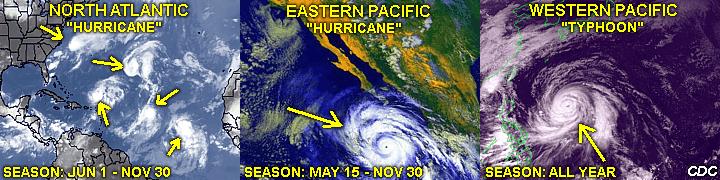
This educational section is for an in-depth view of one of nature's most powerful storms: TROPICAL CYCLONES! These storms are those whirlpools that develop each tropical season over the tropics, what we call "hurricanes" in the Atlantic and East pacific and "typhoons" in the West Pacific. These storms have a very special place in the meteorological world and will be explained in great detail in this section.

Note - This page may take a while to load on some SLOWER connections!


TABLE OF CONTENTS - CLICK TO GO TO PAGE


TROPICAL CYCLONE DEVELOPMENT STAGES

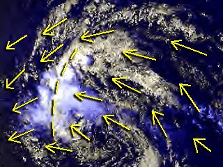
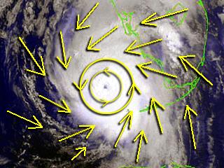
Tropical Wave: This is a low pressure trough (a non-closed low pressure area) moving through the trade winds over the tropical ocean. As many as 100 of such waves (also called inverted troughs, because of their "upside down" appearance on a tropical weather map in the northern hemisphere) move across the tropical Atlantic during the hurricane season for that region, which lasts from June 1 to November 30. Sometimes, such tropical waves can develop enhanced showers and thunderstorms, creating a low pressure area that can further develop into a tropical cyclone (such as a tropical depression or even a tropical storm). On average, about six of such tropical waves go on to becoming a "named" tropical cyclone (tropical storm status or greater) during each Atlantic hurricane season. In the annotated satellite picture, the yellow arrows show a northeast wind ahead of the westward (left) moving wave then a southeast wind behind the convergence line. Since no westerly winds yet exist south of the system, the tropical wave is basically an "open" or "north-south" axis of low pressure (a trough).
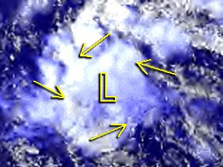
Tropical Disturbance: This is a weak or broad area of low pressure. It can be associated with a developing tropical wave or within a developing area of convection over the tropical ocean. This is a cluster of convective clouds (showers and thunderstorms) that has become persistant and has the potential to develop into a tropical depression. Winds within such a system are normally well under 25-30 MPH. Persistant tropical convection tends to lower surface pressures (called a CONVECTIVE VORTEX), and is vital to tropical cyclone formation under the right conditions (warm sea surface, minimal upper-level wind shear, etc). Besides developing along a tropical wave, tropical broad lows can also form along stalled frontal systems, even remnants of previous tropical storms.
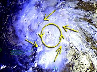
Tropical Depression: This is a tropical cyclone with winds of over 30-MPH but less than 38-MPH. A tropical depression must be a CLOSED low pressure area (at least one closed isobar on a 2-MB pressure interval weather map) to be classified as such. This is the first major stage in tropical cyclone / tropical storm formation.
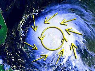
Tropical Storm: Is then the maximum sustained winds (a one-minute mean windspeed at sea level) in a tropical cyclone reaches 38-MPH but less than 74-MPH. The tropical storm usually has well-developed closed cyclonic circulation. Tropical storms are the stage inwhich the tropical cyclone is given a name from a list of names unique to the area that tropical cyclone developed in. In the Atlantic basin, an alphabetic list of alternating male and female first names is used that repeats every six years. A major hurricane or storm that causes exceptional damage and / or loss of life is usually removed from the list and replaced with a new one to avoid confusion 6 years later.
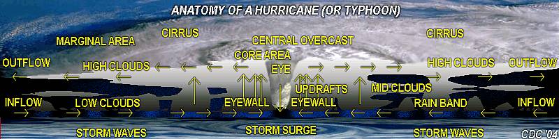
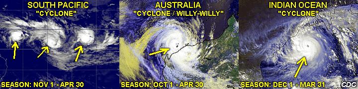
Hurricane: This is the most intense stage of tropical cyclone development. The term "hurricane" (or other name such as "Willy-Willy" in Australia and "typhoon" in the west Pacific) is applied to any tropical cyclone with winds at or over 74-MPH. Hurricanes (called so in the East Pacific and Atlantic) are derived from an Indian name for "bad winds", and represent a tropical cyclone with an intense closed cyclonic wind flow and pressure structure. Once at the hurricane stage, the tropical cyclone is now classified by its destructive power on what is the SAFFIR-SIMPSON scale, rating the storm based on how much damage its winds can do on a scale from 1 to 5. The highest winds ever measured in a hurricane or typhoon have exceeded 200-MPH.
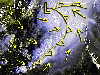
Extratropical Storm: As a hurricane, typhoon, tropical storm, or any tropical cyclone enters the higher (temperate) lattitudes, it begins interacting with the increased temperature gradient as you go from south to north (or north to south in the southern hemisphere). This is where cool, drier air is brought in on one side of the dying tropical cyclone and warmer air is brought in on the opposite side. In the annotated picture, a tropical cyclone has evolved to an extratropical (frontal) system. To its west, cool air had formed a cold front, while warm air surges north east of the remnant low pressure. Note the thunderstorm line along the cold front and drier air "punch" to its west. These extratropical (or even subtropical "hybrid" - as described in the next section) type stages do not always mean the storm is "weakening", but simply "changing" in response to a different environment it was introduced into. In the past, hybrid or extratropical storms of tropical cyclone orgins have caused exceptional flooding events (Such as Agnes in 1974) even wind and / or coastal damage events (such as "The Perfect Storm" in 1991).


HYBRID (SUBTROPICAL) CYCLONES - WHAT ARE THEY?

A "hybrid" (or subtropical) cyclone is a low pressure system that has BOTH the attributes of a frontal system (extratropical or wave cyclone) and a tropical cyclone (such as a hurricane). These attributes are rarely an exact "half and half" between the extratropical storms and their tropical cousins, but a rather involved and variable division of the two. For instance, tropical cyclones have a warm core, and extratropical cyclones have a cold core. The latter has fronts (cold and warm), but tropical cyclones do not. Tropical cyclones have feeder bands of convection, while extratropical cyclones have "waves" or frontal zones instead. The latter also develops in regions of high wind shear and / or high temperature gradients (such as in the temperate zone and is called BAROCLINICITY), while tropical cyclones favor light winds and little temperature gradients for development in tropical regions. Occasionally, and especially between the transitioning seasons (such as spring and fall) cyclones with BOTH characteristics form. They also account for only 2% of cyclone types (compared to tropical and extratropical storms). In the diagram above, a strong subtropical low develops off the SE USA / Florida coast. The first image (NWS and Weathertap.com) to the left is the water vapor image, showing a moist storm center and dry air all around it at high altitudes. One can easily make out where the low pressure center is. The middle picture (NCAR) is that of the surface winds and pressure. The large number of isobars denotes a strong pressure gradient, therefore strong winds (near 50 Knots). The last picture (FNMOC / US Navy) to the right shows the sea-state produced by the storm, with large ocean waves exceeding 20 feet in the normally calm waters (for the month of May) off the SE coast of the United States. Hybrid (subtropical) storms are often insidious when it comes to wind and wave damage. They are large, like an extratropical storm, but also have strong winds, much like a tropical system. Another bad example of a hybrid cyclone was the "perfect storm" around Halloween of 1991.

The two pictures above were taken from a webcam located on top of a sand transfer station on the north side of Lake Worth Inlet, which is on the south side of Singer Island in Palm Beach County, Florida during the morning of May 8. 2007. The provider of the webcam images is the town of Palm Beach (www.co.palm-beach.fl.us). In the two pictures, waves well over 15 feet are slamming into the jetty and breaking into the end of the inlet. This is also north of a very popular surf spot called "Reef Road". Note the wave run-up flooding inland along the side of the inlet in the left picture. These conditions are EXTREMELY dangerous for mariners and anyone standing too close to the breaking waves. Also note the deceptively blue skies and pleasant weather, which can lure beach-goers into a false sense of security, since the intense storm (hybrid cyclone) that is generating the large waves is hundreds of miles away.

In the three pictures above, the hybrid (subtropical) storm appears on visible satellite to the left and right for May 7, 2007 and May 8, 2007, respectively. One interesting change between the two pictures is that the left is much more "extratropical" in appearance, with a cold-front (or shear-axis) and well-defined dry-slot. However, to the right, the dry-slot is not as defined, and wraps completely around the storm. Also, more thunderstorms are developing around the storm center rather than along the fronts, forming almost a large and diffuse "eye" like feature. Sometimes, hybrid systems can "shift" their balance of attribute more towards extratropical cyclones (as in the left picture), or become more "tropical" like (as to the right). Sometimes they can make a full transition to one or the other altogether. Subtropical storms are an important area of interest because of their strange, and often intense character. The middle picture is a webcam shot of Boynton Inlet looking east, showing the large NE swells arriving at well over 10-12 feet. The provider of the webcam images is the town of Palm Beach (www.co.palm-beach.fl.us).


VERTICAL WIND SHEAR AND TROPICAL CYCLONE DEMISE

This diagram above is of three annotated images to show how vertical wind shear can quickly destroy a developing, or even a mature, tropical cyclone. First of all, in addition to warm water and many other factors, winds aloft need to be light to foster a good environment for a tropical system. Simply stated, the thunderstorm convection needs to remain over the SAME area as the developing low near sea surface. If the convection becomes detached from that surface low, the low simply "fills in" since the mechanism (convection) has been removed from it vertically.

In the picture to the left, taken from an airplane over Jacksonville, FL, mild vertical wind shear is depicted by the slanted appearance of the cumulus towers. The pronounced tilting from left to right with height indicates a weak surface wind and stronger wind aloft.

In the two images to the right, tropical storm Chris in 2006 goes from a well-developed tropical storm with 65-MPH sustained winds to a weak 40-MPH storm with completely exposed center in just one day as strong NW winds over the storm literally tear away its "life-giving" convection! The winds around and over TS Chris on August 2, 2006 were a mere 10 knots from the east at both the surface and 250 MB (34,000 feet), then an upper-level low brought 35-Knot NW winds at 250 MB a day later on August 3, 2006, inducing wind shear since the surface (MSL) winds were still from the east. TS Chris quickly dissapated there after.


THE HURRICANE SAFFIR-SIMPSON SCALE

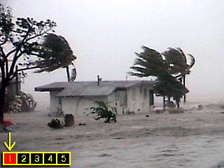
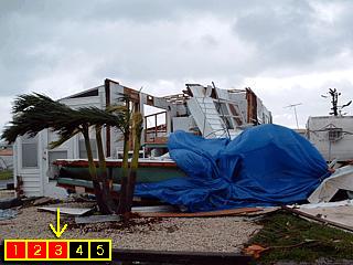
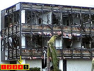
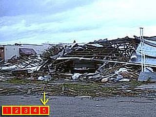
Category One: Winds 74 to 95 MPH. Tree and shrub damage. damage to shingles. un-anchored mobile homes damaged. Storm surge about 3-5 feet. Damage to piers and boats. Examples: Irene in FL Keys in 1999, Gabrielle in FL in 2001, Erin in East-Central FL in 1995.
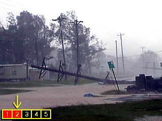
Category Two: Winds 96 to 110 MPH. Roof and window damage to buldings. heavy damage to trees and shrubs. heavy damage to mobile homes. Storm surge typically 5-8 feet. Boats and piers heavily damaged. Examples: Frances in East-Central FL in 2004, Isabel in NC in 2003, Lili in LA in 2002.
Category Three: Winds 111 to 130 MPH. Structural damage to buildings. Flying debris. Severe tree and shrub damage. Mobile homes destroyed. Storm surge typically about 8-12 feet. Storm surge destructive to any low lying coastal areas. Examples: Ivan in FL Panhandle in 2004, Gloria off NC in 1985, Betsy in FL in 1965.
Category Four: Winds 131 to 155 MPH. Extensive damage to most buildings, including complete wall and / or roof failures. Debris becomes deadly missiles. Major coastal flooding with damage and extreme beach erosion. Storm surge can be 12-18 feet. Examples: Charley in SW FL in 2004, Hugo in SC in 1989, Donna in FL in 1960.
Category Five: Winds at or above 156 MPH. Catastropic damage to many buildings, even re-inforced buildings receive major structural damage. Debris battering. Most roofs are blown off. Deforestation of wooded areas. Storm surge over 18 feet (maybe up to 25 feet, or more). Scouring of coastal structures. Category-five storms are very rare. Examples: Andrew in South FL in 1992, Gilbert in Carribean in 1988, Camille in MS in 1969.

The Saffir-Simpson scale was developed by a former director of the National Hurricane Center and a structural engineer to rate a hurricane (or severe tropical cyclone) winds in terms of how much damage is done. This scale ONLY applies to tropical cyclones with winds at or over 74 MPH (hurricanes in the western hemisphere). This scale is the standard in hurricane forecasting eversince.

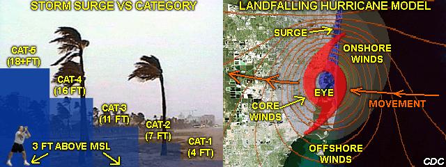
Note: There is one addendum I would like to add to this table about the Saffir-Simpson scale above ... Which is VERY important. The STORM SURGE heights shown are basically for an AVERAGE structured hurricane (25 mile-wide eye) with a fully-developed ocean state / wave envelope that has been nearly a steady-state, and affecting an average coastline. Smaller hurricanes can have a lower storm surge (as with hurricane Charley in 2004, where a storm surge of only 6-8 feet was present, despite 150-MPH category-4 winds). Larger hurricanes, or hurricanes that are rapidly weakening, can have a much larger storm surge despite weaker winds (such as Katrina in 2005 which had a 25 foot storm surge despite category 3 winds) ... This is very important to consider as coastline, sea floor topography, hurricane size, structure, and intensity trends can make the storm-surge versus category height guide practically useless!


PARTS OF A SEVERE TROPICAL CYCLONE (HURRICANE)

The photo-composite diagram above is a picture of a "real" hurricane ("Elena" taken from the space shuttle in 1985) sliced in half showing its internal structure and annotated with labels and arrows showing wind flow. The graphic is NOT to scale. Most people are familiar of what a hurricane (or typhoon) looks like from high above, such as on a satellite picture. A large, white whirlpool of clouds with a "dot" in the center of it. The white swirl is merely the top of the storm, and alot more is going on under this "shield" of high clouds.

In the diagram above, a hurricane (or typhoon) clearly has a rather complicated structure once you get under the high clouds covering the storm. Basically, air flows into the core of the system from great distances and rises (most in the core of strongest updrafts around the clear eye of the storm in the EYEWALL but some in updraft bands called FEEDER BANDS away from the storm core as well). Once rising, any moisture condenses out of the rising air, putting HEAT ENERGY into the atmosphere (called LATENT HEAT OF CONDENSATION). This either sustains or strengthens the storm by maintaining updrafts (thus low pressure at the surface) in the cloud systems. Once the air has risen, it has to go somewhere, so it flows OUT over the same way it came in but at high altitudes. In the eye of the storm, sinking air produces the phemominal storm EYE, where clouds actually disappear!

Also notable in the diagram is the sea surface and STORM SURGE. The storm surge is caused by low pressure under the hurricane (or typhoon) core and strong winds "pushing" the water at the sea surface. Superimposed on this "mound" of water are storm waves of great height, created by the drag of winds over the sea surface. Even away from the hurricane, large ocean waves can exist for great distances. Bear in mind that the "simplified" diagram does not consider the CORIOLIS FORCE, where winds spiral into the storm counterclockwise (or clockwise south of the equator). The low-level inflow spirals counterclockwise into the storm while the outflow, at high altitudes some distance from the storm, actually spirals clockwise away from the system (opposite in the southern hemisphere). Wind flow is only relative to the center of the storm in this diagram for educational purposes. The blue areas under clouds denote rain while the darker shaded clouds are lower in the atmosphere that the lighter shaded high clouds. Diagram by myself with NOAA and NASA providing composite photographs.


CORE REGION OF HURRICANE (EYE AND EYEWALL)

This diagram above is an annotated composite of two radar images of hurricanes Frances and Jeanne (the latter being more zoomed-in) just off the Florida East-Central coast on September 4, 2004 and September 25, 2004, respectively. In these radar images, both storms have a large eye (nearly 70 miles wide in Frances and 40 miles wide in Jeanne), however, only a single main eyewall surrounds the precipitation-free eye region.

The Melborne (private News company) radar image shows higher intensity precipitation as yellow and red when lighter precipitation shows up as green shades. blue (or map color) is NO detectable precipitation. Note the red shades around the eye forming the eyewall with the reddest shaded region or "convective chimney" northwest of the eye. Also notable in the radar image to the right is a "meso-low", a small counter-clockwise circulation on the inner edge of the eyewall. Frances was a category-2 storm with 105-MPH winds while Jeanne was Category-3 at 120-MPH. Both hurricanes struck the same area near Fort Pierce, FL in only a three-week timespan.

This diagram above is an annotated composite of two radar images of hurricane Charley just before striking Punta Gorda, Florida on August 13, 2004. The image on the left shows the precipitation structure of the rather small, but extremely intense, hurricane. The core of the system (eye and eyewall) is circled and zommed in on the right image of the diagram. What is trying to be shown here is the DOUBLE EYEWALL, where a larger (but weaker) eyewall surrounds a smaller (but far more intense) inner eyewall. This phenomina is almost exclusively found only in major hurricanes (those with winds at or over 111 MPH). The inner eye is less than 5 miles wide while the outer eyewall is about 25 miles wide. A so called "moat" region of weaker radar echoes is between the two eyewalls.

The National Weather Service radar image shows higher intensity precipitation as yellow and red when lighter precipitation shows up as green shades. black is NO detectable precipitation. Note that the "space" (or "moat" region) between the two eyewalls has only light green colors, bounded by yellow and red. The most intense portion of the inner-eyewall appears dark-red on the northern side of the rain-free eye, and contains the strongest winds, fastest updraft speeds, and heaviest rains of the storm. This region is referred to as the "convective chimney" and is where the greatest release of latent heat energy occurs in the storm system. Winds in the inner eyewall were at least 145-MPH at the time these images were taken.


VISUAL APPEARANCE OF EYE AND EYEWALL

The diagram above is two pictures taken by myself from inside the eyes of two hurricanes that hit the united states, hurricane Irene in Key West, FL in September 1999 to the left and devastating hurricane Charley in Punta Gorda, FL in August 2004 to the right. In the right picture, a brightening sky appears overhead and the opposite eyewall extends across the lower portion of the picture, causing what is called a "stadium effect". In the picture to the right, a much smaller eye presents a "tube effect" when viewed straight up with blue sky overhead.

The eye of hurricane Irene to the left was about 25 to 30 miles wide, but the low clouds actually broke allowing the eyewall structure of the 85-MPH category-1 (but organized) hurricane to be viewed. The bright clearing is a thin layer of high clouds, not blue sky. The eyewall appears dark because the sun angle at about 9:30 AM. The calm center lasted for about 30 minutes with winds under 5-MPH. Sometimes these low clouds obscure the view of the eye completely, regardless of the storm intensity, allowing the eyewall to only be viewed from an airplane.

In the right picture, the eye and eyewall of much smaller (but far more intense) hurricane Charley forms a very small cylinder, more proportional to a "toilet-paper insert" than a "stadium". Charley's eye was less than 5 miles wide, surrounded by 150-MPH winds, and had a calm center so small an observer only experienced a wind shift in winds that averaged 30-MPH. Note the clear blue area overhead and narrow eyewall appearing through a break in the low clouds.

The diagram above is a composite of two images, the left taken by a NOAA scientist aboard a WP3 "Orion" research aircraft (US Department of Commerce), while the image on the right taken by the US Air Force aboard a WC-130 "Hercules" aircraft (Military). Two of the images are unique in terms of what type of storm is being intercepted. The left picture is a major Atlantic hurricane with a large single eye, the right was taken between the outer and inner eyewalls of double-eyewall system hurricane Charley off SW Florida in August 2004.

The picture on the left was taken while flying into the clear eye at an altitude of 10,000 feet (MSLP). Clearly, the "stadium effect" is obvious with a stout eyewall and clear-blue sky overhead. Note the "blanket" of low clouds. Most likely, the view of this eye would not be visible from the surface due to the low clouds. Being in an airplane offers this awesome view of the storm eye and eyewall in intense tropical systems. Flying through the eyewall is often turbulent while the eye can be smooth. Penetrating these storms by aircraft is paramount for hurricane forecasting by locating the storm while taking measuring pressure and wind speeds.

In the right picture, a far more complicated scene is presented. While passing between the outer and inner eyewalls of Charley, also at 10,000 feet, a view of the space (moat region) between the eyewalls becomes apparent. The weaker outer eyewall still forms a "stadium" while the outer edge of the inner eyewall appears like a wall of clouds to the right, literally INSIDE the outer eyewall that surrounds it. This view was not possible from the surface due to the low clouds (and high clouds from the inner eyewall obscuring any "blue sky"). At the surface, rain did let up and wind slowed within the "moat" region before the inner eyewall destroyed everything.


THE "BIG" AND THE "SMALL" OF TROPICAL CYCLONES

Hurricanes and typhoons (tropical cyclones) can come in all shapes and sizes. The diagram above shows the immense differences in size of three tropical cyclones that broke records for size (measured across the breadth of the tropical storm forced, with speeds of 38-MPH or more, gale wind "envelope"). All storm examples are SCALE COMPARED to the continental United States to show the differences in their size. Most impressive is the size of super Typhoon "Tip", which formed in th west Pacific in October 1979. This tropical monster is also the strongest tropical cyclone on record, with winds sustained at over 190-MPH and a central pressure of 870 MB. Tip measured 1,200 miles across its envelope of gale-forced (38-MPH or more) winds, making it the largest tropical cyclone ever recorded. All statistics in the above diagram are as of early 2010.

Second in the record holders for size is hurricane "Ike", which formed in the Atlantic basin in September 2008. Hurricane Ike took a long journey across the Atlantic (after forming off Africa) and made several landfalls in the Bahamas, Cuba, and finally in Galveston, Texas. Ike's maximum width (across it's tropical storm forced wind swath) was over 900 miles while it was in the Gulf of Mexico. Even more impressive, the envelope of hurricane-forced winds was up to 350 miles across! Hurricane Ike, although a strong category two storm with 110 MPH winds during it's immense size, was the largest tropical cyclone ever observed in the Atlantic basin. Large hurricanes (or typhoons) like this are dangerous because the long distances involved for winds to blow across water, making for a higher-than-normal storm surge and / or waves. When hurricane Ike hit Texas, it had a storm surge comparable to a strong category 4 hurricane, despite it being category 2.

Finally, and on the far right side of the picture ... Look closely and you may find tropical storm "Marco". This storm also developed in the Atlantic in the southern Gulf of Mexico off Mexico in 2008. The gale (tropical storm) forced winds of this TINY storm measured only 10 miles across, literally less than one hundreth of the size of Typhoon Tip's flow field! Marco was essentially a small "meso low" type tropical cyclone, no bigger than a large thunderstorm, yet with a 65 to 70 MPH maximum wind flow around its tiny center. Tropical storm "Marco" was the smallest tropical cyclone on record, even smaller than the former record-holder, cyclone "Tracy" with a 30-mile wide flow field, that formed near Darwin, Australia in 1974. Tracy, despite it's small size, had 125 MPH winds and a small "pinhole" eye. More is explained on what a "pinhole eye" is in the next section below.

The core regions or tropical cyclones, particularly the relatively clear eye and surrounding eyewall, also come in a variety of shapes and sizes. The typical eye diameter of a hurricane (or typhoon) is about 25 nautical miles. In the diagram above, two eye size extremes are shown, with Hurricane "Isabel" in 2003 (in the Atlantic Ocean) to the left, and hurricane "Wilma" in 2005 (in the Western Caribbean Sea). Both storms are category-five hurricanes, with wind speeds of 175 and 190 MPH, respectively (as of 2010, Hurricane Wilma was also the most intense tropical cyclone ever in the Atlantic basin, with a minimum pressure of 882 MB). The impressize difference is the eye diameters of the two storms. Isabel has a very large eye, over 70 nautical miles (NM) across, while Wilma's eye is less than 2 1/2 NM wide! Wilma set a record for the smallest eye ever observed in a tropical cyclone. The record for the largest eye was in Typhoon "Winnie" in the Pacific, with an eye diameter of nearly 230 NM!

In each example, a close-up of the eye is shown in an inset to the lower-left. Isabel's eye is very wide, like a large "salad bowl" or "tea-cup" proportionally (yellow overlay). Wilma's small eye, called a "pinhole eye", is much taller than it is wide, with a geometric proportion comparable to a "tall vase" or "toilet paper roll" vertically. Inside such an eye, the inset in each example to the upper-left shows what the eye may look like visually, with the wide eye presenting a "stadium effect", but the narrow eye just a small patch of blue sky overhead, looking more like a "cylinder". Both of these storms are extremely dangerous in their ways. Isabel was not only a storm with a large eye, but notice the little meso-lows inside the eye in the low clouds, forming a "pinwheel" effect. Isabel was also an "annular hurricane", with little or no feeder bands / convection other than the main eyewall around the large eye (the eyewall is like a "truck-tire").

Hurricane Isabel, had it affected land at that intensity, would have exposed anything unfortunate enough to be there to a long period of destructive winds and high storm surge / waves due to the large size of the storm (and fetch of wind over water). Annular tropical cyclones / ones with large eyes also change intensity slowly. The small eye can be (and usually is) the inner eyewall with the outer eyewall hidden from view on the satellite images. Small core storms (such as Wilma), can change intensity very quicky, even suprisingly (Wilma intensified from 75 MPH to 190 MPH in less than 24 hours)! Had Wilma affected land at such an intensity, a small path of complete devastation would have been inflicted by the small eyewall, very similar to that of a large tornado. Other notable examples of storms with small "pinhole eyes" were hurricanes "Opal" in 1995 and "Charley" in 2004 in the Gulf of Mexico and Florida, as well as Typhoon "Forrest" in 1983 in the Pacific near the Philippines.


IMPORTANT TROPICAL CYCLONE REGIONS

This diagram above is an annotated composite of two satellite images. The image on the left denotes the important regions of a tropical cyclone relative to the storm's movement: The RIGHT-FRONT, RIGHT-REAR, LEFT-REAR, and LEFT-FRONT quadrants (in clockwise order). The important quadrants are labeled in white and separated by orange intersecting lines. The storm motion in this example is toward the upper-left (or northwest). The yellow arrows denote low-level inflow into the storm. The picture on the right also shows low-level inflow via yellow arrows but the importance of FEEDER BANDS, denoted by orange lines. Feeder bands are squall lines of showers and thunderstorms caused by lifting of air due to low-level CONVERGENCE. These lines of storms can be quite a distance from the actual "core" of the tropical cyclone.

In the diagram to the left, we see the important QUADRANTS of a tropical cyclone, based on its motion. The most important quadrant is the RIGHT FRONT quadrant (also called the RFQ or FORWARD-RIGHT SIDE). It is in this area where low-level convergence is maximized AND the forward speed of the storm ADDS to the wind in that part of the storm! The second most dangerous quadrant is the REAR RIGHT quadrant, also because the storm movement adds to the storm winds as well as low-level convergence being high in that region. In a nut-shell, the RIGHT SIDE of any tropical cyclone is referred to as the NON NAVICABLE SEMI-CIRCLE (by shipping / marine interests) or the "DIRTY SIDE" of the storm. For example, if a storm is moving North at 20-MPH and has 100-MPH winds, the right side of that storm will have 120-MPH winds! The left side of that same storm, however, will only have 80-MPH winds. Also note that the CONVERGENCE, where the yellow arrows get CLOSER as air spirals INTO the storm core, is highest on the right side of the storm. Surface winds also are backed more in the RFQ region and can contribute to tornado development due to higher helicities (directional wind shear) AND convection induced by the convergence (forcing). Left of the storm's movement, winds are less severe and convergence is not as intense.

To the right, another diagram shows that the "convergence effect" can extend very far from the center of the tropical cyclone. At least three major feeder bands, shown by the orange lines, can be seen extending hundreds of miles to the southest on the right side of the storm (Allison in 1994). Note that a DRY SLOT has developed as drier air got involved in the lee of the tropical system. Acting as a front (or dry "punch"), this dry air has enhanced the convection east of it. Feeder bands can cause brief bursts of stormy weather and heavy rainfall far from the core of the tropical cyclone. Keep in mind that the right side of a tropical cyclone is worst only NORTH of the equator. In the southern hemisphere, the LEFT side is the dangerous side because storms rotate clockwise (opposed to counter-clockwise).


TROPICAL CYCLONE TRACKS

The two images in the diagram above concern examples of actual and forecast tracks of tropical cyclones in the Atlantic basin. To the left is a screen snapshot from my own Visual BASIC program called "TChart 3.0" to track hurricanes with the 1995 Atlantic storm season's record-breaking tropical system tracks loaded. Each grey line represents a track for a tropical system, with the white tracking line being hurricane "Erin", which hit east-central Florida. As one can imagine, hurricane tracks seem "random" or taking on a "mind of their own". In actuality, tropical cyclones are embedded in a much larger and complicated flow in the atmosphere (from the easterly trade winds in the tropics through the westerlies of the higher lattitudes). Small disturbances within the atmosphere, such as high-pressure ridges and low-pressure troughs, are crucial to the path of tropical cyclones.

To the right is a sample storm (hurricane Isabel in 2003) being forecasted by the NHC (National Hurricane Center), a government firm responsible for all tropical weather in the Atlantic and Eastern Pacific areas. This is a very important forcast because it shows not only the current location of the tropical cyclone (hurricane Isabel), but a forecast track, denoted by the black line, based on many human and computational decisions of where the storm will be up to 3 days down the road. The white area is the "error region" (famously referred to as the "Cone of Uncertainty") showing where the storm could ALSO be if is deviates from the forecast track. The cone of error becomes larger the more time out into the future the forecast goes. Times, and sometimes intensities, are also given along the forecast track, as well as any watches or warnings that may be required along the coast near the expected landfall region.


DESTRUCTIVE ELEMENTS IN TROPICAL CYCLONES

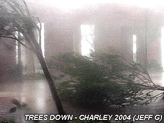
Strong Winds: The most obvious element in a hurricane (or any strong tropical cyclone) is the strong winds. Technically, any wind over gale forced (tropical storm forced begins at 38-MPH) can do damage by uprooting trees and damaging property. When winds reach 74-MPH or higher, damage increases radically, with each 50% increase in windspeed doubling the dynamic force of that wind. For example: A 75-MPH wind is TWICE as damaging as a 50-MPH wind, 100-MPH wind is FOUR-TIMES as damaging as 50-MPH, and a 150-MPH wind is NINE times as severe as 50-MPH! This is because the DRAG FORCE of wind, caused by aerodynamics and dynamic pressure of the wind flow, increases with a formula related to the SQUARE of the velocity. This is why a minimal hurricane with 75-MPH winds only causes leaf and minor tree damage but a hurricane like Andrew with 165-MPH winds back in 1992 can destroy an entire city.
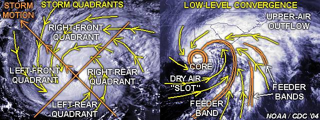
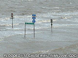
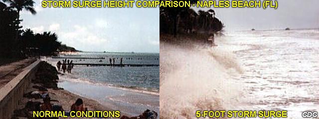
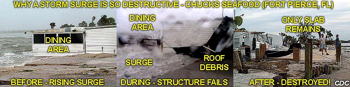
Storm Surge: This is basically a dome or "mound" of water caused by the intense low pressure of a tropical cyclone coupled with the driving-force of the winds "pushing" the water along (mass transport). In deep water, the storm surge in intense tropical cyclones is only a foot or two high, caused by the low pressure, but contains a fast moving surface current called MASS TRANSPORT that flows with the storm winds (more enhanced to the right side of the storm core in the northern hemisphere). As this flow (and "mound") of water comes ashore, it interacts with the coastline, tides, and undersea topography and can be over 20 feet high in strong hurricanes! Storm surge rises quickly with the onset of the storm core and often floods coastal areas, threatening life by drowning, damaging beachfront property, marinas, even the coastline itself. Storm surge is most severe in and to the right (northern hemisphere) where the storm center crosses a coast. 90% of hurricane victims die from drowning in floods caused by the storm surge.
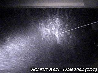
Heavy Rains: The rain bands and thunderstorms associated with a tropical cyclone, regardless of its wind intensity, are often heavy and accumulating. Such heavy rains can even occur well inland from weakening tropical systems, such as the incredible flooding from the remnants of hurricane Agnes (in NY) back in 1974. It is not uncommon for a tropical system to dump 10-15 inches of rain as it moves over a given area. Slow moving systems, such as hurricanes Irene (S FL) in 1999 and Mitch (Central America) in 1998 have dumped 20 to 30 inches of rain, respectively. Other tropical cyclones only dump a few inches of rain, especially if moving fast. Rain from tropical cyclones, especially hurricanes (referred to as "violent rain"), is nearly impossible to measure, because it falls "sideways" with the winds and "misses" the rain guages. I have seen wind blow water into a building wall "coating" it with several inches of water. Between gusts, when the wind let up briefly, all that water came cascading down at once in a waterfall!
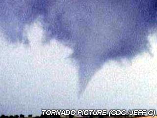
Tornadoes: The spiral bands of a hurricane (or tropical cyclone) also have the capability to spawn tornadoes. Tornadoes can occur in any area of the tropical cyclone but the threat is much higher on the right-front side of the storm (northern hemisphere) because the low-level convergence and directional wind shear (helicity) is higher in that region of the storm. Often the leading rain bands spawn shallow MESOCYCLONES (rotating updrafts) that could produce a brief tornado, although these mini-supercells are much smaller than their "Great Plains cousins". Tornadoes can and have occurred in land-falling tropical systems (land creates more low-level drag and shear). Some tropical cyclones spawn more tornadoes than others, depending on the structure of the precipitation. There are even eyewall tornadoes (not to be confused with MINI-SWIRLS, which are simply eddies embedded in the eyewall winds). For example: Hurricane Beulah in 1967 spawned over 115 tornadoes!


STORM SURGE - THE BIG KILLER IN HURRICANES

The diagram above is a model for the storm surge depicting AVERAGE height of the storm surge based on the Saffir-Simpson category of that storm (hurricane or typhoon) as well as the portions of a landfalling storm most suseptible to storm surge. The image to the left is a stock picture of South Beach, Florida with palm trees plus an image of myself used for comparison. The blue squares represent the height of a "model" surge relative to mean sea level (the beach was 3 feet above sea level where the picture was taken) in different category (1 to 5) intensity examples (5 being the highest to the left). As you can see, a category-1 hurricane (or typhoon) has the smallest surge, averaging about 4 feet. Such a surge will merely flood the beach (up to my knees in the graphic). A category-2 storm is much higher, up to my neck, and probably will flood the beachfront property. The water continues to rise radically with category, with a category-4 storm producing a devastating surge of about 16 feet. A category-5 simply covers the entire beach, with only treetops above the water, and continues inland for great distances destroying just about everything.

The storm surge height examples are only AVERAGE heights based on the category of the storm, with the storm being of "average" size (eye 25 miles wide). Shallow water off the beach, such as in the FL Keys and along the gulf Coast often makes the storm surge much higher. The same storm that produces a 15 foot surge on the FL East coast can produce a 25 foot surge on the Gulf Coast! Some coastlines have deep water off the beach, such as in Hawaii. In that case, the storm surge may be lower than the average heights shown here. The shape of the coastline also plays an important role. A storm surge can funnel into a "cornering" or "concave" shaped coast and become much higher due to the "venturi effect". In Bangladesh near India, a tropical cyclone in the 1970's killed nearly a million people with a storm surge of 45 feet above normal due to a shallow and cornering coastline! The storm size and intensity trends can completely throw-off the figures shown in the "text-book" table above! The highest storm surge in the US, exceeding 25 feet, was observed during hurricane Katrina in 2005 along the Mississippi coastline.

In the picture to the right, a sample hurricane (with its distinct symbol and isobars in red) is overlaid over a satellite image of Miami Beach, FL. The storm is making landfall from right to left (general westerly direction) and the eye has just come ashore north of South Beach. The grey shading represents the extent of the CORE WINDS of the storm, and as you can see, they are more pronounced north of the center. As explained earlier, the worst winds are near and to the right of where the center comes ashore (northern hemisphere) in the dreaded "right side" of the storm. High water effects are shown in blue shading, and is obvious in the same areas of strongest onshore winds. however, south of the center, and in the hard offshore winds (pushes water back OUT to sea), water level is near and may actually be BELOW normal along the mainland! This is why just a small difference in position can make such a big difference in the effects of the storm. Such an example was with hurricane Ivan in 2004: Mobile, Alabama was spared from the storm surge even though it was on the left side of the eyewall, but just 10 to 20 miles to the east, across the opposite (right) side, storm surge reached as high was 20 feet near Gulf Shores and Orange Beach.

Here is an annotated diagram of two images of the SAME BEACH - Naples in Florida. The left image was taken on a typical Florida summer afternoon with light winds and normal conditions. The picture to the right was taken with 50-60 MPH on-shore winds (from the west-northwest) and tides running at least 5 feet above normal. The view in both pictures is to the south and you should be able to see the difference caused by the storm surge. Compare the water level in the right picture to the people standing on the beach to the left. Storm surge is responsible for 90% of hurricane victims due to drowning (The Galveston hurricane of 1900 was such an example where 6,000 people drowned in the surge). Storm surge simply raises the sea level allowing flooding of coastal areas while subjecting beachfront / coastal structures to the destructive power of the wind waves and / or swell that may be superimposed atop the storm surge.

Above is an annotated diagram comprised of three images of Chuck's Seafood restaurant and bar in Fort Pierce, Florida being destroyed by storm surge in hurricane Frances in september 2004. In the leftmost picture, during the beginning of the storm, the dining room area is still intact. The tides are quickly rising and have covered the small beach that extended 20 to 30 feet in front of the dining area (at normal tide levels). Note that the berm (higher area after the beach) is already being eroded. This was the bay, not the ocean, but being near Fort Pierce inlet, tides quickly rushed into the bay with 5-6 foot waves atop the surge.

The second (middle) image shows the dining area of the restaurant being destroyed. The rising water, with large battering waves superimposed, exposed the structure to the wave energy. The structure first experienced a "curtainwall" failure on the side exposed to the bay. After this wall collapsed, surge and waves flooded the dining room damaging support columns and more walls. Finally, winds gusting over 100-MPH lifted the now un-supported roof and hurled it 150 feet across the Fort Pierce causeway road. The event was spectacular indeed, and a perfect demonstration of the power water can have (only a cubic yard of water weighs nearly a ton)!

The rightmost image was taken a day after the storm from the opposite side of the now demolished dining area. Only a foundation and floor slab remains, with the water level in the bay (Indian river) returning back to normal. These images were taken by myself with permission from the restaurant owner (Chuck), who unfortunately lost his home to storm surge as well.


TROPICAL CYCLONES NAMES AROUND THE WORLD

Above is a diagram of three locations where HURRICANES and TYPHOONS exist. Two of these areas are the NORTH ATLANTIC, EAST PACIFIC (INCLUDING THE CENTRAL PACIFIC), where the name HURRICANE is used. The North Atlantic hurricane season runs from June 1 through November 30 while the Eastern Pacific starts May 15 and also runs to November 30 (the CENTRAL PACIFIC, near Hawaii and west to the date line, is similar, but fewer storms develop there each season). The West Pacific (west of the 180-degree date line) is quite different because there is no "real" season for tropical cyclone activity. Storms can develop anytime of the year, but more so during the northern-hemisphere summer. In this area, the term TYPHOON is used, but otherwise the storm is the same thing as a hurricane. A SUPER TYPHOON denotes a typhoon with winds at or over 145-MPH, and the "SUPER" word is used more in the Pacific (a SUPER HURRICANE is a hurricane with winds at or over 145-MPH, but used rarely).

Above is another diagram of three locations concerning the South Pacific, through Australia, and Indian Ocean. The terminology used is a TROPICAL CYCLONE (or just "CYCLONE") in the same sense as a hurricane or typhoon, where the storm reaches 74-MPH or more. In Australia the term WILLY-WILLY is sometimes used for the CYCLONE strength.

In the South Pacific, cyclones devlop mostly from November to April (because summer is opposite south of the equator that north of it). In Australia, the season is from October through April. Note that the storms spin in the OPPOSITE direction (clockwise) in this part of the world. In the Indian Ocean, the season is rather strange for above the equator, from December to March, and storms can develop outside this time frame. The storms north of the equator in the Indian Ocean rotate counter-clockwise (such as near India) but clockwise south of it (such as near Western Australia or even Southeastern Africa). The term CYCLONE is used in all three areas with the exception being WILLY-WILLY sometimes in Australia.

As with anything in nature, "rules" such as tropical cyclone seasons and regions of formation simply DO NOT exist. The above diagram shows two cases of such "odd-ball" occurrances. Tropical storm "Peter" developed in the North Atlantic basin in DECEMBER 2003 in a region climatically impossible for such a storm to develop. The storm was over a warm region of water and missed by hostile upper-level winds that would have disrupted it. Meanwhile - far to its northwest, heavy snow was falling in the northeast Atlantic coast of the United States, after all it was late fall - But "nature" doesn't know that as long as the conditions are right for a tropical cyclone to form!

A very similar and even more interesting event occurred off Brazil in the SOUTH ATLANTIC in April 2004, shown to the right. A strong category-1 hurricane, with a full-eye and banding, lingers off the Brazilian coast. Again, conditions just became right for it to form, despite the South Atlantic being almost always discouraging to tropical development (the big words here are "ALMOST always"). The Brazilian storm moved ashore near Santa Catarina and did about 335 million dollar in damage, spawned tornadoes, and killed fishermen at sea. Since a hurricane season and therefore a list of names is non-existant for that part of the world, the storm was simply named "Catarina".


INTERESTING FACTS ABOUT TROPICAL CYCLONES

  • HURRICANES and TYPHOONS are commonly referred to as two different storm systems. These are just DIFFERENT NAMES for the SAME type of tropical cyclone, with winds at or over 74-MPH, in the Western Pacific (west of 180 degrees) versus the Eastern Pacific and Atlantic (it is to the west of 180 degrees where the term Typhoon is used).


  • The term TORNADO and HURRICANE are often confused. These two types of storms are VERY different from each other and form under much different conditions. Thunderstorms produce tornadoes, while hurricanes are born over the warm tropical oceans in the tropical lattitudes. Hurricane winds are less than that of a strong tornado, but cover a much larger area.


  • As of 2004, only three category-five hurricanes struck the United States in history: The "Labor Day" hurricane of 1935, hurricane "Camille" in 1969, and hurricane "Andrew" in 1992. Out of these, the 1935 storm destroyed Flagler's rail system in the Florida Keys while "Camille" was the strongest hurricane to ever hit the US and "Andrew" was the most expensive.


  • All hurricanes have weaker winds than the strongest tornadoes, however, strong hurricanes can have winds gusts that rival the winds in a moderate to strong tornado. Peak winds in a category-five hurricane, such as "Andrew" in 1992, can gust over 200-MPH. Compared to a tornado, this is a strong F3 or even approaching an F4 tornado (on the Fujita F0 to F5 scale). Such damage occurs over a much larger swath than a tornado in the rare event such a hurricane makes landfall.


  • As tropical cyclone sustained winds exceed 150-MPH, the term "super hurricane" (or "super typhoon") is used. In hurricane terms, this is a strong category-four storm and higher.


  • A strong hurricane (or typhoon) can release enough latent heat energy (which is just 3% of the total heat energy available to it at any give time) equivalent to detonating 500,000 (yes, half a million) Hiroshima type atomic bombs per day. In megatons, this is about 6,000 megatons. In wattage, about a billion megawatts (or a million gigawatts). In horsepower, about 1.3 TRILLION horsepower - Gentlemen, start yer engines!


  • Eyewall "replacement" is when within a strong (hurricane or typhoon) tropical cyclone core, convection first forms into another eyewall around the original one forming two concentric eyewalls. The outer wall then shrinks and intensifies as the inner eyewall weakens until just one (often more intense) eyewall is left. This is why some very strong hurricanes fluctuate in intensity.


  • A tropical cyclone is a convective vortex, fueled by convection known as CISK (Conditional Instability of a Second Kind). Simply this means warm air rising, releasing stored heat energy, creating low pressure, and spinning due to the Coriolis force. Another way to look at it ... It is powered by the Sun (nuclear fusion). The sun heats the tropical sea surface over a long period of time, storing the heat energy since water holds a lot of energy when heated, then releases it later to sustain a tropical cyclone.


  • Tropical cyclones often intensify more at night than during the day under favorable conditions (low shear, warm water, etc). This is because the tops of the high-altitude clouds in the hurricane cool (heat radiates to space) at night while the sea surface under remains the same. This increases updrafts in the storm by enhancing convection.


  • Hurricanes (and typhoons) are very difficult "engines" to start and sustain. As mighty as they are, they are very "delicate". Wind shear aloft of only 30 knots or so can severely disrupt a tropical system. The storm also needs to be over deep water of at least 78.8 degrees or higher to survive. land, mountains, cold water, fronts, even dry air can also destroy a tropical cyclone.


  • Ever wait, and wait for a pot of water to boil? This has a lot to do with tropical cyclones because of the property of water and how much energy it takes to evaporate (or boil) it. Each calorie (unit of heat) raises a gram of water 1 degree C. When that same gram of water reaches 100 degrees C (boiling point) or evaporates, an additional 540 calories must be added just to get it to vaporize! Now, when the gram of steam (or water vapor) condenses back to a gram of water, the 540 calories "stored" (that's latent heat energy) in the vapor is released, usually back to the air, heating it, and making it rise.


  • Hurricanes and typhoons come in all shapes and sizes. When measuring such diameters, the width across the widest portion of the gale-forced (38 MPH and up) wind-field envelope is used. Super typhoon "Tip" in 1979 had a gale field width that covered over 1,200 miles of Western Pacific ocean, while tropical cyclone "Tracy" that struck Darwin, Australia in 1974 had such a wind-field only 30 miles across. In October 2008, Tropical Storm Marco's tropical-storm forced wind envelope was even smaller at a mere 10-15 miles across!


  • Hurricane "Wilma" in October 2005 was the strongest tropical cyclone ever recorded in the Atlantic basin with core winds of about 185-MPH, and lowest pressure of 882 MB. This exceeds the previous record set back in 1988 by hurricane "Gilbert" with 888 MB! Typhoon "Tip" in 1979 was the strongest in the world with core winds over 190-MPH, a central pressure of 870 MB, and a storm diameter (gale-forced wind envelope) of 1,200 miles across!


  • Effects of a category-five hurricane can be incredible and frightening. In the 1935 "Labor Day" hurricane, winds near 200-MPH turned a beach into a sandblast that literally ripped the skin off some of the victims who did not already perish in the 20 foot storm surge. Some were recovered with no clothes, no skin, and only their shoes and belts on them! Hurricane "Camille" in 1969 created a sandblast effect too, so violent that sand actually sparked when it hit metal poles! Hurricane "Andrew" in 1992 actually pulverized concrete from the brute force of its winds and rain.


  • A storm surge, especially from a large tropical cyclone, is a type of TIDAL WAVE. Suddenly raising the sea level, especially if the land back from the coastline is low-lying, can introduce INCREDIBLE amounts of sea water far inland, often with torrential violence similar to a tsunami. During hurricane "Camille", a freighter ship, anchored offshore before the storm, wound up 7 miles inland after the storm! The crew did not even realize it until the water receded and they saw trees all around them!


  • People actually CHASE tropical cyclones, just as others in the Midwestern US chase tornadoes, ranging from amateurs to scientists, even the military, who fly into them. Chasing a tropical cyclone is MUCH different than chasing a thunderstorm or tornado, and requires different tactics in interception, forecasting, and safety. There are only a small handful of "hurricane chasers" compared to other "storm chasers".


  • The term "Hurricane" means "ill" (or "evil" wind, and cames from the Indians (Native Americans) of the Caribbean based on the stormy weather God "Hunrakan". The term "Typhoon" has its similar origins with the Chinese, based on the word "Tafeng", which means "the great wind". Other words for severe tropical cyclones around the world originated in similar ancient ways, such as the word "cyclone" itself, which originated from the Greek word "kyklos" meaning coil (of snakes).


  • Most deaths (nine out of ten from un-suspecting, non evacuated populations) in tropical cyclones are not related to the strong winds, but from drowning due to flooding and / or storm surge. Hopefully, this has changed due to timely warnings and adherance to them from people.


  • The highest storm surge ever recorded in the United States was 34 feet associated with the right side of Hurricane Katrina along the Mississippi Coastline (near Biloxi and Gulfport) in August 2005. The largest storm surge ever seen on earth was 43 feet at Bathhurst Bay in Australia from an 1899 cyclone. The deadliest storm surge was a surge of over 20 feet from the Bhola cyclone in Bangladesh's Bay of Bengal back in 1970 that killed over a half million people.


  • CHASING TROPICAL STORMS AND HURRICANES

    Tropical cyclones, like any other storm and weather phenomina, can be "chased" and observed. Chasing a hurricane (or typhoon) is, however, a dangerous and logistically challenging activity. There are MANY factors one must understand and consider in order to successfully observe a tropical system, and many of these points are presented in the documentation below.

  • A hurricane (or typhoon) can have winds near or exceeding that of the core region of a significant tornado. A hurricane (or typhoon) chaser must go THROUGH those dangerous winds. Hurricanes and typhoons CANNOT be observed from a distance. An 80-MPH wind can easily knock you down. 120-MPH-plus winds can lift you clear off your feet and carry you through the air!


  • There are road closures / blockades and police checkpoints, even well before / after the storm. You are often turned away if you do not have the proper "credentials". If you lie about who you are, you will be questioned or even arrested.


  • Curfews are often placed in hurricane (or typhoon) disaster areas. If you violate (are simply on the roads with no "good" reason to be out) a curfew and caught by authorities, you WILL be arrested, no questions asked.


  • Roadblocks are not only caused by authorities. Trees fall, there is lots of debris, and roads flood in a hurricane (or typhoon). You can be trapped for a very, VERY long time. Flooding and storm surge could also block you in for a WHILE.


  • Gas stations are NOT open and / or will NOT have power. Storing gas in you car is also a VERY BAD idea. Low pressure in a hurricane (or typhoon) can cause gas cans to leak with fumes and can even explode! There is NO roadside or emergency service during a hurricane / typhoon (that means that if you get stuck and / or hurt, you are on your own)! Phone service, even cellular, often gets cut-off too.


  • Power often goes out in a hurricane. Stores are closed, most people leave the "hurricane (or typhoon) target area". You must bring your own food, water, even medications (if any) with you for at least the duration of the chase, which can be 36-48 hours. Also remember, you cannot get gas if you run low!


  • Plan to not sleep during most of a hurricane (or typhoon) chase. Don't fall asleep behind the wheel. Hotels are also CLOSED. If you do get any sleep, and are not kept awake by "adrenaline", you most likely will be "cat napping" in your car if you are lucky. Sound easy? Try staying awake for 52 hours straight - I did that in Hurricane Lili in 2002 and was hallucinating until I finally got sleep!


  • Plan to get WET - Really wet. Cold and wet feet, shoes, pants, even in places you never imagined (the money in your wallet even gets soaked)! Your vehicle also can get very wet and it makes a nice smell after a chase! This water is no way "clean" either, it is FILTHY, but I will get to that subject down below. Plan on many changes of clothes, or even throwing clothes away altogether. Raincoats and umbrellas simply don’t work and / or get ripped apart by the winds. Rain drops feel like acupuncture and can even cause welts on the skin at 100-MPH plus!


  • Gear, such as radios, electronics, and camera equipment can suffer water damage easily. This type of damage is often NOT covered by any warranty, and can be VERY expensive to replace or repair.


  • Coastal areas flood during a hurricane (or typhoon) with fast-moving seawater. You can drown, have your vehicle flooded and / or swept away if parked in an area prone to storm surge. Not all buildings / structures can handle a hurricane (or typhoon) and its surge and may even collapse. You could possibly get yourself buried under rubble!


  • There is a lot of flying debris in a hurricane (or typhoon). Remember, hurricane (or typhoon) chasing involves being INSIDE the wind field of the "vortex" (larger than a tornado). A worst-case would be getting hit with a chunk of sheet metal and killed, not because of the wound it may cause, but failure to get attention to that wound (such as bleeding to death) - Remember, no fire department or 911 operates in a hurricane! You WILL be with yourself and your wound. Chase with a person with training in CPR and have a first aid kit handy in the event you need it (this implies using the "buddy system").


  • Flood waters in a hurricane (or typhoon) are loaded with all kinds of nasty things. In addition to debris and mud / sand, you often have dead fish, seaweed, grass, bugs, oil and gas spilled from cars or boats, bacteria, even raw sewage. Watch for snakes and even gators flooded out of their "homes" too by the floods!


  • Looting and public upset often occur during and after a hurricane (or typhoon) disaster. Respect property and land areas as if it was an ordinary day. Uptight residents during a hurricane (or typhoon) can and WILL take the law into their own hands! I have seen residents with guns with them in hurricane chases of 2004, and a "storm chaser" can easily be mistaken for a "thief" and shot. Looting has its own dangers as stealing and / or violence can be introduced into an already bad situation. Watch out for such "anarchy".


  • The boss, neighbors, and spouse. Hurricane (or typhoon) chasing involves a last-minute "impromptu" chase. You cannot give a 3-day-off notice in most jobs one day before you take the time off! Make sure your boss, and even spouse, understands as you will not be gone for hours as on a tornado chase. Also, plan on being "cut off" from these people because of power / phone outages too. Hurricane (or typhoon) chasing often takes DAYS, not HOURS.


  • Emotional and mental trauma. Prepare yourself mentally for what you may experience since it may be really, REALLY ugly. Hurricane Katrina in 2005, a worst-case scenario of this example, taught me that very well, and made myself, a 35 year old grown man at the time, cry for days and feel really sad. The footage was great, but then the utter sympathy set-in, as well as memories of seeing houses, boats, debris, cars, even people floating by and / or being ripped apart. Experiencing such surreal and horiffic events "does things to you".


  • Mental and emotional "labeling" ... This is a really NASTY one, especially the "mental" aspect of it. I have LOST many relationships because of "hurricane chasing", the most recent one being after I showed "in-your-face" video of waves breaking over a seawall from a waterproof camera enclosure. I was called "crazy" and even worse "dumb" and "stupid". I was told that "storm chasing" is tolerable, but "hurricane chasing" is not due to the famous "you make me worry sick over you". Most of the time, do not expect to be in a happy relationship AND be an avid hurricane (or typhoon) chaser AT THE SAME TIME! This is because the inherent danger in hurricane chasing is higher, and many people simply cannot accept that.


  • As mentioned earlier, a lot of bad things, including pathogens, can be present in floodwater in a hurricane (or typhoon). After hurricane Katrina in 2005, I was treated for a persistent cough accompanied by severe night sweats, aches, and fevers. Upon examination and diagnosis, I was given antibiotics and treated for "E Coli infection in my respiraratory tract", and it was a stubborn infection too. This was because bacteria (most likely from raw sewage in the water) was atomized by the whipping winds and I un-avoidably breathed it in. This is why it was so dangerous to be near the floods in New Orleans after hurricane Katrina.


  • In a strong hurricane (or typhoon), you MUST be in a REINFORCED CONCRETE building such as a parking garage, prison (or jail), government building, bomb-shelter, hospital, etc. This is because the winds rival that of a strong tornado, and you will simply NOT be safe in a weaker structure such as a wood-frame building. Such weak structures are subject to disintegration in an upper-category (4 and 5) hurricane (or typhoon). In addition to the strong structure, you MUST also be high enough above sea level where storm surge will not become an issue.


  • Being caught out on the streets during a curfew can literally land you in jail, and authorities are taking a more "no tolerance" attitude at enforcing this. For example, in hurricane Jeanne in 2004, I saw a person (who happened to be an innocent storm chaser from Nebraska) wandering around during the storm and calm eye while documenting it at the same parking facility my group and I were at. He did not tell the local police EXACTLY what he was doing and why he was there, and was arrested. My group was up-front with the same police crew and the officer simply waved to us and said "good luck" as they took off with the other person in the back seat of the police car!


  • As mentioned earlier, authorities impose road blocks and checkpoints for a reason. Do NOT lie to police to get past a road block, tell them WHO you are and WHAT you are doing. Sometimes, weather equipment on your vehicle may help convince law officials you are a "serious" weather chaser, but I cannot guarentee that. Be HONEST, and if they turn you away it is for your own safety. I heard stories where hurricane (or typhoon) chasers said they were with a government or news agency to authorities to get on a barrier island that was closed off. While "experiencing" the storm, the same authorities checked the "credentials" given and found out they were not true. When the storm chasers returned on that same road to get off the island, the same officials placed them under arrest.


  • You must be SELF-SUFFICIENT. You can possibly be stuck for a LONG time. Water, food, fuel, batteries, tools, medicine, first aid kit, supplies, even an extra spare tire, are all VERY important. You WILL need them, So PLAN accordingly.


  • Remember, this is a hurricane (or typhoon) DISASTER. There is no AAA, 911 is ignored, and you are also ON YOUR OWN once the storm is on top of you. I have had a fellow chaser get locked out of his running vehicle as the "auto safety" child lock engaged. Now, locked out of the vehicle, it took nearly an hour to break the trunk lock, cut through the back seat (yes, he had to CUT it), and open the door from the inside. The "buddy system" helped here, indeed. Imagine this happening to you alone and all your tools are inside your car. Even worse, imagine this happening with a rapidly rising storm surge and / or impending 130-MPH eyewall!


  • Ninety percent of all hurricane (or typhoon) deaths are from drowning. Hurricane Katrina in 2005 illustrated this very well. Storm surge and flooding is a VERY bad thing in a tropical cyclone. You can easily lose your vehicle, equipment, even your life to storm surge flooding. Consider a high place for your vehicle, equipment, and most importantly, yourself if observing a tropical cyclone in a region expecting a storm surge. For safety, this should be at LEAST ten (10) feet above the expected height of the storm surge. I do not even recommend attempting to witness or document a high storm surge.


  • I willingly and logistically accepted all these risks and with planning and experience was able to chase hurricanes with minor incidences and a highest degree of RELATIVE safety as possible. I would consider all these factors for anyone willing to take up hurricane (or typhoon) chasing.

  • ABOUT THE "HURRICANE HUNTERS"

    One of the most exciting and seemingly "daring" excursions with tropical meteorology are carried out by both the US military (Air Force and Navy) and the US Government (Depertment of Commerce - NOAA) where special weather scientists actually fly over, around, and even THROUGH these violent storms to gather more knowledge about them! The US Air Force "53rd Weather Reconaisance Squadron" flies modified WC-130 "Hercules" aircraft into storms, while NOAA's Aircraft Operations Center (the US Department of Commerce) flies two WP-3 "Orion" aircraft as well as a highly modified Gulfstream IV jet into storms. We call these amazing people the "Hurricane Hunters", and their expertise has helped vastly improve forecasting and information about tropical cyclones. The "Hurricane Hunters" literally "chase hurricanes" with an aircraft!

    Over the summer of 2005, and in the midst of an extremely busy hurricane season and helping a fellow worker Jim Edds with CBS, I was lucky enough to fly with NOAA's "Hurricane Hunters" aboard their Gulfstream Jet for hurricane Katrina when it was in the Gulf of Mexico. Fellow storm chaser and videographer Jim Edds, working for CBS Miami, also went aboard NOAA's WP-3 "Orion" for hurricane Ophelia in 2005. In the picture composite above, the jet aircraft to the left is NOAA's Gulfstream IV on the tarmac at Mc Dill Air Force Base in Tampa, Florida. Flight director Paul Flagherty and Jim Edds are in the foreground. The middle picture is myself holding one of many "DROPWINDSONDES" released into the storm during the flight. The picture to the right is one of two WP-3 "Orion" aircraft on standby in the AOC hangar at Mc Dill AFB.

    Both NOAA AOC (Aircraft Operations Center) and the US Air Force (53rd Weather Reconaisance Squadron) have one major mission: To gather as much information about a tropical system, whether it is the storm itself or the atmospheric environment around it, and relay it to the National Hurricane Center in Miami. The "Hurricane Hunters" are essentially "data collectors", no more and no less. It is this data collected that is used by many weather agencies (National Weather Service, National Hurricane Center, etc) to get an idea of what the storm is doing and where it is going. Each aircraft is modified for extended endurance and is packed with some of the most sophisticated computers and instrumentation imaginable. A person getting on one of these flights will not only be amazed by the storm itself, but the array of equipment used ... And ofcourse, must have a strong stomach too!

    The main job of the NOAA Gulfstream flights is to examine the atmospheric environment around and over the storm. This is done from very high altitude, up to 45,000 feet, which is also the service "ceiling" of the Gulfstream IV jet. Many "dropwindsondes", enclosed in a parachute-borne cardboard tube, are released from the jet and free fall to earth, measuring wind, moisture, temperature, etc until impact with the sea surface. Much is learned about the environment around and over the storm, which often dictates its track and intensity. The other two NOAA WP-3 aircraft, as well as the Air Force's WC-130's, fly a much lower (and bumpier) altitude mission, THROUGH the eye of the storm, sometimes with a spectacular "stadium" effect view, anywhere from 1,500 feet up to 10,000 feet, depending on the storm's intensity. Similar dropwindsondes are also released into the storm core and eye, and measure windspeeds and pressure of the storm.

    These "Hurricane Hunter" activities, working together, provide an invaluable source of information about the environment around the storm as well as it's intensity. Their expertise and service will be second to none for years to come, so that loss of lives and property will be mitigated through better and more accurate track and intensity forecasts if a tropical system does threaten.


    HOW YOU CAN PROTECT YOURSELF AND PROPERTY

    With all this said about just about every aspect on tropical cyclones, this last section covers the MOST IMPORTANT aspect of all - How to protect YOURSELF, your loved ones, and your property! Tropical cyclones are "ocean born" storms, and while many remain out over water and bother no one (maybe except for fish and shipping interests), some do come ashore and pack quite a punch when they do. In addition, hurricane activity is on the INCREASE due to higher water temperatures, and this "increase" is sure making it's mark as of 2004 and 2005. We MUST all be ready, in case the "unthinkable" does (and eventually WILL) happen.

  • The Atlantic hurricane season is from June 1 to November 30 each year. Please note that in different parts of the world, tropical cyclones form at DIFFERENT times of the year. In this case, for simplicity, we will focus on the Atlantic basin hurricane season. With that said, everyone in a hurricane prone region MUST be prepared for hurricane season by the START of hurricane season (by June 1 for the Atlantic). Many tips on these "precautions" are outlined below.


  • Prepare a hurricane "kit" and "plan" to go along with it each year for you and your family. The most IMPORTANT item in this kit is bottled water, and should be one gallon per person per day for AT LEAST 7 days (7 gallons per person). Next is a 7 day supply of food in non-perishable format such as canned goods, packaged foods, freeze dried, even MRE's (meals ready-to-eat). Have snacks added to your food list too, along with a MANUAL can opener, a portable stove or cooking unit, and disposable plates / silverware. Do NOT wait until the last minute to make this supply list, do it at the START of hurricane season and keep it in a safe place in your home. Remember FOOD and WATER are the most important things in your hurricane "kit".


  • In addition to your hurricane "kit", which you can do at the START of hurricane season, always be prepared as the season "picks up". If you take prescription medications, make sure they are frequently filled and ready. Make sure you have an adequate supply of items for babies and elderly members. Pillows and blankets also should be kept near all your hurricane supplies along with a first aid kit and even more important, battery powered essentials. It may be also wise to purchase a portable generator (or even have one installed for your home).


  • During a storm, you will NEED to know what is going on as you are cut off through loss of power and telephone. Cellular phones may work sporadically early in a storm, but are not reliable thereafter. Battery powered devices such as flashlights, portable radios, and battery operated TV's should be kept close at hand with your hurricane supplies. Make sure you got a fresh supply of batteries for the devices mentioned, at least a week's worth. It is also a good idea to provide some activities in your "kit" such as toys or board games to help pass time in the event of a storm.


  • Make sure you have an adequate supply of hygiene and toiletry items (bathroom tissue, soap, shampoo, disinfecting spray such as Lysol, towels, etc). Another good idea is having a gallon of bleach in the case of contaminated water. A few drops per gallon of water can disinfect it after about 10 minutes if you are unable to boil it. Many outdoor outfitters supply a water filter to do this too. For pets, be sure to have plenty of food and necessities for them too. I understand that this is alot of stuff, but if a storm devastates your area, you WILL need them.


  • Documents and insurance is another VERY important thing to consider. Any important documents you may have should be sealed in a water-tight enclosure and kept in the safest possible place during a hurricane disaster. Along with such items you can also include keys, emergency phone numbers, spare cash, and insurance records. Speaking of insurance, you MUST be covered if you are a homeowner. Make sure your landlord or leaser has the right coverage if you rent or lease too - Ask!


  • Make sure about the insurance coverage you are entitled to as a homeowner. There are many types of insurance, many of which does NOT fall under the regular homeowner's insurance. There is FLOOD insurance, and this is SEPARATE from homeowner's - Something really to consider as most hurricane damage is from flooding. Some "zones", especially near or on the coast, require "windstorm" insurance in addition to homeowner's. Many policies have "hurricane" deductibles, which differ between damage caused by a "named" storm (of tropical origin) and other storm damage (such as a thunderstorm).


  • Purchasing homeowner's insurance can be difficult, and nearly impossible in some hurricane prone regions, such as Florida. NEVER try to purchase insurance when you "think" a storm will threaten, as most underwriters will not honor a hurricane damage claim within two weeks of a new policy. Also, and VERY important, keep a detailed INVENTORY of your home and its contents. Videotape and / or photograph your home and its contents and keep the video and pictures with your policy in your "safe place" including the rest of your important documents. Save sales receipts on newer additions and personal items of higher value added over time.


  • With all these preparations and precautions met, we will now go over DIRECT PROTECTION for your property. Have you ever seen tape cris-crossed over windows in a hurricane threatened area? Well, forget it - DO NOT use tape on your windows! Taping windows offers NO protection, may even ruin the window, and is a waste of time. Windows can ONLY be protected with properly secured shudders or plywood. There are many ways to protect your home with shudders and panels (and if you rent, your landlord or leaser BETTER have them too).


  • The cheapest method, by far, is PLYWOOD. Preferably 3/4" thickness, it can be cut to custom fit the windows on your home. Be SURE you have plywood sized and ready at the START or even BEFORE hurricane season. The drawback of plywood is that is requires proper anchoring (such as a wall anchor screw or bolt) and is sometimes difficult to install. The next is hurricane PANELS, which are simply corrugated metal sheets that are secured into pre-installed anchors or bolts (the anchors remain in the wall, and the panels are hung and secured). Panels are often cumbersome and heavy (see leftmost picture in graphic above), but easier to put up than plywood. The initial sizing and anchor bolt installation should be done by a professional contractor, but many panels come with new homes.


  • The more expensive but convenient hurricane protection for windows are SHUDDERS. These can remain permanently affixed to a home or apartment, many with an aesthetic appearance, and closed by simply lowering them, closing them, and some are even electrically operated. Many hurricane shudders are available, and all must be installed professionally. They may be expensive but this is offset by their convenience and value they may add to a home. The best time to purchase such shudders for your home is outside of hurricane season. Many homes even come with these preinstalled, particularly with Bahama style shudders (middle picture in graphic above).


  • There is some speculation that "window films" will protect against a hurricane. This is not fully the case since it is only a lamination and may "contain" shattering fragments to some extent, but it will not protect against flying projectiles penetrating the glass. If you have window films installed, you should still shudder-up your home with the proper protection mentioned above. If your home or apartment has a garage, be sure the door is "hardened" against hurricane debris. This is done by reinforcing the backside of the door with steel or lumber planks (such as 2x4's). Always observe ladder safety when making any preparations. Make sure someone else is holding the ladder as you go up, and use extreme care to avoid powerlines and other hazards.


  • Now you are prepared up to now, but what do you do when a hurricane is threatening your area? It can get quite crazy out there as you scurry around your town and there is no gas, ATM's have no cash, shelves are empty in the grocery and hardware stores, or even worse, you get into an accident since everyone is on edge and making mistakes driving. I have seen ALL this in a hurricane warning area. Let me stress this, do NOT wait until the last minute, have your kit and supplies ready BEFORE all this, and you will not have to "rush". I will continue with what to do in the event of a threatening storm.


  • When you see a storm that is close by, but not actually threatening, it is better to be "safe than sorry". Unpack your plywood or panels and keep your hurricane "kit" and documents you put away in a conspicuous place. Now is the time to stock up on gas too, whether it is for your car or generator. Top off your car's fuel tank. Have adequate fuel for your portable stove handy too if you got one. Also, get some cash from the ATM, and put it in a safe place. Do this EARLY, since these commodities are the FIRST to run out. If storing gas, do NOT store it in your home or car. Be sure it is in an approved gas can or container.


  • For your pool or jacuzzi you really do not need anything special for it during hurricane season, however, you must consider several important things in case a storm threatens. Disconnect power to any pool equipment, but DO NOT drain the pool, you might be able to use the water from it for non-potable purposes (such as flushing toilet). Loose lawn chairs can also be tossed into the pool (be careful of the pool liner if equipped) as the water will cover them and they will not blow around. Make sure you take down any loose objects outside and secure anything that may blow around. It is also a good idea to trim your trees to reduce wind drag on branches if a storm hits. Be very careful of powerlines. Filling your bathtub is also a good idea as you might need the extra non-potable water.


  • Boats and hurricanes do not mix. Anyone who has a boat will need to protect it, but after first preparing for protecting their family and home, since a boat is considered a "luxury" item. Boats in marinas close to the ocean are often moved farther inland and secured with extra lines (ropes) which are rigged with slack to accomodate the changing water levels and winds. Smaller boats can simply be trailered to a "safer" place, even your garage if you have one. Larger boats, such as sailboats (sails removed) and yachts, often are moored in a bay or cove (away from docks they can slam against and cause damage) and hoped for the best. It is also important to know that draw bridges often close and remain locked down during the latter part of a hurricane warning. NEVER, EVER ride a storm out on a boat!


  • Upon a threat from a hurricane in your area, you will first be placed in a hurricane WATCH, meaning hurricane conditions (74 MPH winds or higher) are possible in about 36 hours. This can be upgraded to a hurricane WARNING where hurricane conditions are EXPECTED in your area in about 24 hours. You may also see a TROPICAL STORM watch or warning, which means the same thing, but for a milder storm with winds less than 74 MPH. Now it is time to protect your home and put your family "plan" into action. You should be prepared LONG BEFORE the onset of tropical storm and hurricane forced winds. When the storm hits, everyone should be inside and in the safest (most central) room of the building. Up until now, I am assuming that you are living in a non-evacuation area, and I will now need to touch the subject of EVACUATIONS.


  • Evacuations are one of the most important preventative activities in a hurricane warned area. Evacuations can either be VOLUNTARY (you decide for yourself if you want to leave your home) or MANDATORY (you HAVE TO get out). Law enforcement and emergency services are responsible for imposing and controlling evacuations. Many public shelters open in respose to evacuations, and if you must leave, you will most likely wind up at such a shelter. Evacuations are often MANDATORY for coastal (storm surge prone) communities, and farther inland, based on the CATEGORY (1 to 5) of the impending storm. Anyone in a mobile / prefabricated home MUST leave.


  • You have several choices in an evacuation. You can simply LEAVE the hurricane area, which usually requires a long roadtrip on possibly congested roads, or go to a designated shelter in (or near) your area. This is another reason why you should have your car full of fuel. Bring only your essentials to the shelter (food, water, radio, flashlight, etc). Unfortunately, most public shelters do not allow pets, so either leaving the area early enough or making arrangements for them prior to the evacuation is the only option in that case. It is also a very good idea to bring the important documents mentioned earlier WITH YOU during an evacuation. Make sure you follow shelter etiquette and any guidelines as you might be there for some time with many other people.


  • During the storm, and depending on its intensity, you may hear a variety of sounds and noises, some possibly very loud or frightening. Remember, stay calm and if you have children, keep them close and comforted (sing to them, play games, etc). Panic is very bad, whether at home or in a shelter, and can endanger yourself and others. If someone gets hurt and needs help during a storm, you will have to provide the all help you can provide since emergency services (fire, 911, etc) WILL NOT respond until it is safe for the emergency providers to be outside! You are on your own for the duration of the storm, must be self sufficient, and wait it out. Be sure to listen to the radio / TV as they will tell you when it is safe to go out of your protection / shelter.


  • If the exact center of the storm passes over your location, the "noise" and driving wind / rain may abruptly lessen or even stop. This may be the "eye" of the storm passing by and can last from minutes to hours (based on the eye's size, storm motion, and your position in it). The storm is only half-over, so DO NOT go outside to see what it looks like. This may be enough time for temporary efforts such as first aid or hastily moving dangerous debris, but soon the winds will resume from the opposite direction as before, with equal (and often greater) violence. Remember, wait for the "all clear" sign on TV or radio.


  • Hopefully, based on how well you prepared, and the worthiness of the structure you chose to spend the storm (hopefully you followed the guidelines here), you and your loved ones will be in good shape. Once it is safe to go outside, do so with GREAT caution as there may be debris (broken glass, boards with nails, etc) and other hazards such as flood waters and downed powerlines. Treat any downed wire or cable like a deadly snake! Speaking of snakes, watch for any "wildlife" that may also have been driven from their "home" too by the storm! The storm may be over, but depending on how strong it was, the aftermath is now beginning.


  • If your area was hit by a weak system (such as a tropical storm or category 1 hurricane), damage may only be some downed trees and roof damage (or no damage at all). Power should soon be restored (if it even went out) and once that is done, you can take down the window protection and put your unused hurricane supplies away for another time. If the storm was very catastrophic, the scene after can be much more difficult to comprehend, even disturbing. Your home could have extreme damage, like a missing roof. Your neighborhood may be un-recognizable. Your car could be flipped. Such an un-nerving and disquieting experience may be hard to take in and accept, but must not provoke panic.


  • Emergency personnel, as well as the US army in extreme cases, often patrol down devastated areas offering help (if needed), making a "head count" of "survivors" (such as YOU), or even evacuating people in case the area is deemed unsafe. This is where your essentials and time you spent preparing pay off. You will have to wait until help reaches your area (such as FEMA and the Red Cross) as you "live off" your supplies in the meanwhile. Sounds grim and scary, but you WILL be allright because you planned the way you should have - Think about that. Also, use care and apprehension with strangers, especially passing through your area without any official uniform or ID - Looting is very common in disaster areas before order is restored.


  • Once basic infrastructure such as law enforcement, food and water supply, and even electricity is established, it is now time to assess the damage (if any) from a compensation standpoint. Remember your insurance records and documents in that safe place? Now you may need it. Contact them as soon as possible so an adjustor can check the damage and assess the repairs needed. Be patient, this may take time, as MANY others have gone through the same ordeal too. Avoid any "scams" after a disaster. This can range from over-charging for food and other commodities to unfair re-building and contractor work. NEVER accept an verbal repair estimate from a contractor passing through - Get it in writing and check his or her credentials! Report such "price gouging" or illegal activities to law enforcement immediately.


  • After 1995, many new structures were built using what is sometimes called "Miami-Dade building code standards", in response to hurricane Andrew back in 1992. Insist on these codes, and ask about them, whether rebuilding or constructing a new home. It is very smart to support awareness and even charity on such occasions (I donated to the Red Cross after Katrina, for instance). Accept the fact that as long as we live in a hurricane prone region, this is the only thing we can do: Be prepared, handle the storm (if it happens), and act properly afterwards in a professional and calm manner. I do hope the information provided here is of great help on this subject.


  • MORE INFORMATION ON HURRICANE AWARENESS

    Seeking more information about protecting yourself, property, and loved ones? Be sure to visit this great site on this subject by the National Hurricane Center by clicking their link on HURRICANE PREPAREDNESS WEEK!

    You can also find out lots of helpful information at FEMA (Federal Emergency Management Association) by clicking on their site here at FEMA!

    Do you want to help or volunteer to a great cause? Check out the site for the American Red Cross by clicking their link here at AMERICAN RED CROSS!


    HTML File "schurr.htm" - Developed By Chris Collura

    To Return To The HOME Page Of This Site Click The "INDEX.HTM" Link Here!