
| This section is for storm chases done in the central / Midwestern United States during the year of 2024. This includes all storm chasing activities (including any major chase "expeditions") during the year of 2024 in the central USA (aka "Tornado Alley"). For 2024, all chases in the central USA will be logged in this section, with many of the chases being possible "spot" chases / major severe weather "setups" chased. Here you should find many pictures of lightning, tornadoes, hail, strong winds, along with many severe thunderstorm elements. Keep in mind that this chase log is scientific evidence and portrays my on-going storm chasing research. It has been placed on this page for easy reference and meteorological interests. Please do not plagiarize or copy this document to other sites for distribution. Note - This page may take a while to load on some SLOWER connections! |
STORM CHASING - CENTRAL UNITED STATES - 2024 CHASE LOG


| CHASER NAME | HOME / BASE CITY | CALLSIGN | CHASE DATES | OCCUPATION |
| CHRIS COLLURA | DEERFIELD BEACH, FL | KG4PJN | 4-6 To 4-13 | IT CONSULTANT |
| HAIFENG HU | TAMARAC, FL | N/A | 4-6 To 4-9 | VB CONSULTANT |

|
Flying into the Dallas, Texas area during the evening of April 6, 2024 (from Fort Lauderdale, Florida). |

|
The day before the eclipse, April 7, had good weather with fast-moving high clouds. Here is myself at a park just west of downtown Dallas. |

|
Sub begins to dim near Hatfield, Arkansas during the early afternoon of April 8. |

|
Moon half-way covers the sub between first-contact and totality, at roughly 1 PM CDT. |

|
Close up of partial stages of eclipse (using solar filters). |

|
Canon HD camera with solar filter using a magnetic mount with the sun obscured in the viewfinder. |

|
Obscured sun (70%) by 1:30 PM CDT viewed through thin low clouds passing by. |

|
Wide view of total eclipse at about 1:48 PM CDT. The bright dot to the lower right is Venus. |

|
Myself taken with smartphone, with the eclipse, Venus, and "360 degree dawn" above the horizon at 1:50 PM CDT. |

|
Medium view of totality, which lasted over 4 minutes. |

|
Incredible corona of sun during totality. |

|
Less exposed image, showing "Bailey's beads" (top right), and large solar prominence (bottom). The prominence was very bright and visible to the naked eye - Twice the size of the earth! |

|
Totality ends at just after 1:52 PM CDT. Note the "diamond ring" effect! |

|
Moon continues across the sun, leaving about 80% covered just before 2 PM CDT. |

|
Horse drawn rides at an adjacent horse ranch after the eclipse. |

| CHASER NAME | HOME / BASE CITY | CALLSIGN | CHASE DATES | OCCUPATION |
| CHRIS COLLURA | DEERFIELD BEACH, FL | KG4PJN | 5-4 To 5-29 | IT CONSULTANT |
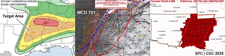
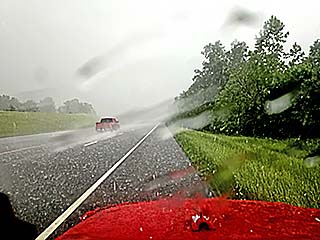
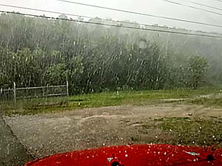
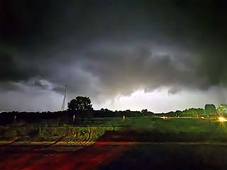
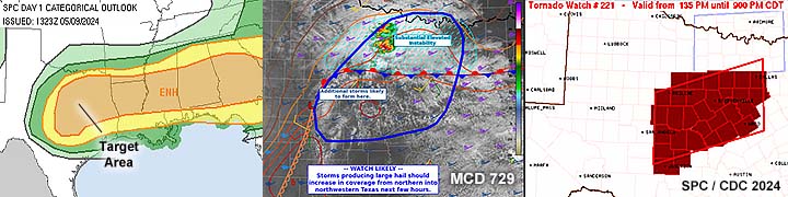
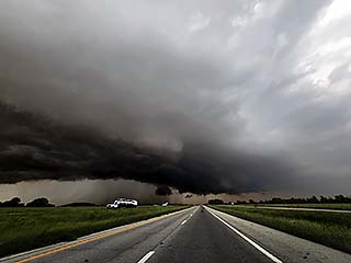
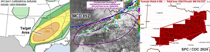
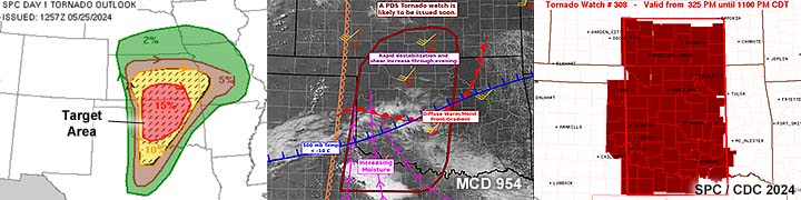
1). May 6, 6:00 PM - Interception and indirect penetration of an extremely severe and tornadic thunderstorm from Dewey to Logan Counties, Oklahoma from near Highway 183 southeast of Putnam, and northeastward south of Okeene along SR 51 past Hennessey towards Orlando. The storm was an HP supercell storm, with a long track that was followed for several hours. Multiple funnel clouds were noted with this storm, with a low-contrast tornado, mainly rain wrapped, noted looking north southeast of Okeene and eastward towards south of Douglas. The core of this storm was not directly penetrated. Strong RFD winds, gusting 70 to 80 MPH, were noted southeast of Okeene, probably associated with the south side of a broad, rain wrapped tornado. Albeit low contrast and poor visibility, a very faint view of a cone tornado was barely visible briefly looking north. Other conditions encountered were torrential rains, 1" hail, and frequent lightning. I did not continue with this storm after dark, but eventually this same storm complex would move northeast and devastate Barnsdall, Oklahoma with a powerful tornado just prior to 10 PM. Conditions causing the storm were surface heating, a dryline / Pacific cold front, low pressure area, and a strong upper trough. Documentation was digital stills and HD / 4k video. A 2022 Jeep Renegade was used to chase the storm. A PDS (particularly dangerous situation) tornado watch was in effect until 11 PM CDT.
2). May 6, 9:30 PM - Observation of a very severe thunderstorm in Canadian / Kingfisher Counties, Oklahoma near Waterloo Road and Highway 81 near Okarche. This tornado-warned storm was a classic to HP supercell after dark. The storm had frequent lightning and a brief lowering / wall cloud was noted on the southwest side of the storm. The core of the storm was not penetrated but contained strong winds and large hail (some 1" pieces were noted on the roadway). Conditions causing the storm were surface heating, a dryline / Pacific cold front, low pressure area, and a strong upper trough. A 2022 Jeep Renegade was used to chase the storm. A PDS (particularly dangerous situation) tornado watch was in effect until 11 PM CDT.
3). May 6, 11:30 PM - Observation, from a stationary location (hotel) of a severe thunderstorm in Cleveland County and in Moore, Oklahoma just west of I-35. The storm was a powerful line / bow segment (multi-cell) storm cluster. A tornado warning was issued for this storm for possible embedded QLCS rotation to my north. Winds with this storm gusted over 80 MPH, with small hail and frequent lightning. Power was knocked out from this storm at times. Conditions causing the storm were a dryline / Pacific cold front, low pressure area, and a strong upper trough. Documentation was digital stills, audio, and HD / 4k video. A 2022 Jeep Renegade was used to chase the storm. A PDS (particularly dangerous situation) tornado watch was in effect until 11 PM CDT.
4). May 8, 7:00 PM - Observation and penetration of a severe thunderstorm near Watts, Oklahoma in Adair County along Highway 59. The storm was a brief classic to HP supercell within a line of strong and severe storms. The storm was outflow dominant as it was under cut by cool air. Hail to 1", lightning, 50 to 60 MPH winds, and heavy rain was observed. The storm had weak rotation as well. Conditions causing the storm were a dryline / Pacific cold front, low pressure trough, surface heating, and an upper trough. Documentation was digital stills and audio. A 2022 Jeep Renegade was used to chase the storm. A tornado watch was in effect until 10 PM CDT.
5). May 8, 8:30 PM - Interception, observation, and indirect penetration of a severe thunderstorm near Shady Point, Oklahoma in Le Flore County along Highway 59. The storm was a classic to supercell on the south end of a line of strong and severe storms. The storm was briefly supercellular with a wall cloud and inflow banding. Hail to 1", frequent lightning (with some close hits), 40 MPH winds, and moderate rain was observed. The core was not directly penetrated. Conditions causing the storm were a dryline / Pacific cold front, low pressure trough, surface heating, and an upper trough. Documentation was digital stills and audio. A 2022 Jeep Renegade was used to chase the storm. A tornado watch was in effect until 10 PM CDT.
6). May 9, 6:30 PM - Interception, observation, and penetration of a very severe thunderstorm from Hamilton to McLennan County, Texas along Highway 84 and SR 317 and between Hamilton and Moody. The storm was a classic to HP supercell, and the southern storm of two supercells, but outflow dominant. The storm was penetrated (hook sliced) and hail over 1", frequent lightning, 60 to 70 MPH winds, and torrential rain was observed. The storm caused tree damage and some power outages. Conditions causing the storm were a dryline / Pacific cold front, low pressure trough, surface heating, and an upper trough. Documentation was digital stills, HD / 4k video, and audio. A 2022 Jeep Renegade was used to chase the storm. A tornado watch was in effect until 9 PM CDT.
7). May 12, 7:00 PM - Observation of a strong thunderstorm from near Sterling City, Texas in Green County and southeastward to northwest of San Angelo and near Highway 87. The storm was a right split supercell storm, with some persistent rotation noted. Classic to HP in nature, the storm was elevated over a shallow cool air layer north of a frontal / outflow boundary. Occasional lightning, 40 MPH winds (mainly RFD), heavy rains, and small hail was noted with this storm. An area of rotation was also noted, with brief wall cloud, RFD clear slot, "swirl" in the cloud base, and a small, truncated funnel. Conditions causing the storm were a dryline / stationary frontal boundary, low pressure trough, surface heating, and an upper trough. Documentation was digital stills and 4k video (time-lapse). A 2022 Jeep Renegade was used to chase the storm.
8). May 15, 5:30 PM - Observation of a strong to severe thunderstorm west of Littlefield, Texas in Lamb County and near SR 54. The storm was part of a multi-cell cluster of high-based strong and severe storms. The core was not penetrated. Light rain and frequent lightning was observed as well. Conditions causing the storm were stalling cold-front, surface heating, low pressure trough, and an upper trough. Documentation was digital stills. A 2022 Jeep Renegade was used to chase the storm. A severe thunderstorm watch was in effect until 10 PM CDT.
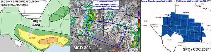
9). May 16, 6:00 PM - Observation and indirect penetration of a very severe thunderstorm from northwest of Rankin, Texas in Upton County, and eastward along Highways 67 and 190 as far as Menard County. The storm started out as a classic to HP supercell storm, and eventually evolved to an intense bow segment. The storm had a powerful RFD area, and a rotating wall cloud was also noted. The storm also had a striking visual appearance, especially during its later stages of evolution. The core was not directly penetrated, but contained very large hail (even two major "hail spikes" were evident on the base reflectivity radar product out of MAF). Conditions encountered were some heavy rain, occasional lightning, small hail, and 60 to 70 MPH winds (mainly RFD), with blowing dust. Conditions causing the storms were surface heating (recovery of a cool pool), outflow interactions, a weak surface trough, and a strong low-latitude upper trough. Documentation was digital stills. A 2022 Jeep Renegade was used to chase the storm. A severe thunderstorm watch was in effect until 11 PM CDT.
10). May 19, 7:30 PM - Interception, observation, and penetration of an extremely severe and tornadic thunderstorm from near Roll, Oklahoma and eastwards towards Custer City in Custer County along SR 33 and Highway 183. The storm was an HP to classic cyclic supercell storm. Some small tornadoes / funnels were noted near Roll, with a large, wedge tornado observed looking west of Highway 183 west of Custer City and north of SR 33. This storm also caused another tornado near El Reno / Mustang after dark, but I quit chasing the storm since it was night, so I did not see that one. Other conditions observed were extremely strong winds, over 80 MPH in some cases, especially RFD. Inflow into the storm was over 60 MPH at times. Large hail exceeding 2" was observed falling, along with extremely heavy rain, and frequent lightning. The storm also had a striking visual appearance, with a "mother-ship" or "stacked plates" presentation. The storm caused damage from both the RFD and tornadoes. Conditions causing the storms were surface heating, a dryline, surface trough, and a strong upper trough. Documentation was digital stills, audio, and 4k / HD video. A 2022 Jeep Renegade was used to chase the storm. A severe thunderstorm watch was in effect until 10 PM CDT.
11). May 21, 5:00 PM - Interception and indirect penetration of a very severe and tornadic thunderstorm in Cherokee County, Kansas and near Highway 400 east of Cherokee. The storm was a classic supercell storm, and a weak tornado was observed during the maximum intensity of the storm. The storm also produced frequent lightning with some close hits, heavy rains, small hail, and 60 MPH winds. The core was not directly penetrated, but contained large hail. Conditions causing the storms were surface heating, a dryline / Pacific cold front, surface trough, and a strong upper trough / low. Documentation was digital stills, and 4k / HD video. A 2022 Jeep Renegade was used to chase the storm. A tornado watch was in effect until 10 PM CDT.
12). May 22, 9:30 PM - Penetration of a severe thunderstorm along Highway 69 north of Eufaula in McIntosh County, Oklahoma. The storm was an elevated HP supercell and was actually tornado warned. Conditions encountered were 60 MPH winds, torrential rains, small hail, and lightning. Conditions causing the storms were a cold / stationary front, icentropic lift (elevated), surface trough, and an upper trough. Documentation was digital stills. A 2022 Jeep Renegade was used to chase the storm. A severe thunderstorm watch was in effect until 5 PM CDT.
13). May 22, 11:00 PM - Penetration of a severe thunderstorm along Highway 69 / 75 near Atoka, Oklahoma in Atoka County. The storm was an elevated HP supercell and was also tornado warned. Conditions encountered were 70 MPH winds, torrential rains, lightning, and hail up to 1". Conditions causing the storms were a cold / stationary front, icentropic lift (elevated), surface trough, and an upper trough. Documentation was digital stills. A 2022 Jeep Renegade was used to chase the storm. A severe thunderstorm watch was in effect until 5 PM CDT.
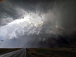
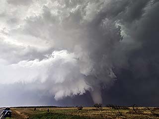
14). May 23, 7:30 PM - Interception, observation, and penetration of an extremely severe and violent tornadic thunderstorm from near Hollis, Oklahoma from Highway 62, and southeastward to near El Dorado in Jackson County near SR 6 and SR 34, and slightly NE along SR 6 past Olustee and Altus. The storm was a violent classic cyclic supercell. The storm was first observed from initiation north of Childress, Texas and west of Hollis, Oklahoma on Highways 83 and 62. The storm was followed east and then southeast, as it turned right relative to the mean storm vector and vorticity fields. At first a funnel was observed, with full occlusion and RFD cut. A storm merger also occurred at this time, when the storm was near Hollis. A land-spout tornado was then observed south of Gould. Finally, the main, and most violent cycle of this supercell occurred northeast of ElDorado, Oklahoma. This is where a powerful multi-vortex tornado moved east to near SR 6, and was observed at close range, evolving to a wedge and "barrel" as is slowly moved east to the northwest of Olustee. The supercell also had a striking visual appearance, with inflow tails and striations, and a near perfect RFD cut (sun and blue sky visible through it - revealing the "internal structure" of the supercell like a "slice into a tall layer cake" - while the violent tornado was still in progress)! Afterwards the storm evolved to HP mode near Altus and the tornado became rain wrapped as it dissipated, after being on the ground for at least 30 minutes. The core of this storm at this stage was penetrated near Altus. Previously the more intense core had grapefruit sized hail. Other conditions encountered were large hail to 2", torrential rains, 60+ MPH inflow winds, 70 to 80 MPH RFD / HP core winds, and frequent lightning. Conditions causing the storms were surface heating, a dryline, stationary outflow boundary, surface trough, and an upper trough. Documentation was digital stills, audio, and HD / 4k video. A 2022 Jeep Renegade was used to chase the storm. A tornado watch was in effect until 11 PM CDT.
15). May 24, 5:30 PM - Observation of severe thunderstorms along Highway 377 from near Madill, Oklahoma in Marshall County, and southward past the Red River to near Callisburg in Cooke County, Texas. The storms were a multi-cell to super-cellular cluster of severe thunderstorms producing large hail. The cores of these storms were not directly penetrated. Conditions encountered were 40 MPH winds, small hail, and frequent lightning. Conditions causing the storms were surface heating, a dryline / Pacific cold front intersection, weak surface trough, and an upper trough. Documentation was digital stills. A 2022 Jeep Renegade was used to chase the storm. A severe thunderstorm watch was in effect until 10 PM CDT.
16). May 25, 5:00 PM - Observation of a severe thunderstorm in Roosevelt, Oklahoma in Kiowa County and near Highway 183. The storm was a left-split supercell storm that produced large hail, and was on the northern side of a cluster of strong and severe storms. The main group was not penetrated. A wall cloud and brief funnel was noted with this storm on the western side, before outflow from a cool pool cut it off. Conditions encountered were 60 to 70 MPH wind gusts, with dust, lightning, moderate rain, and small hail. Conditions causing the storms were surface heating, a dryline, outflow boundary, low pressure area, and a strong upper trough. Documentation was digital stills and HD / 4k video. A 2022 Jeep Renegade was used to chase the storm. A PDS (particularly dangerous situation) tornado watch was in effect until 11 PM CDT.
17). May 25, 6:30 PM - Observation of a severe thunderstorm from near Seiling in Dewey County, Oklahoma, and eastward on SR 51 to near Hennessey. The storm was on the south end of a cluster of strong and severe storms, and was also an HP supercell producing large hail. The core was not penetrated. The storm was tornado-warned but was clearly undercut by cool air from the south. Other conditions encountered were 40 MPH winds, lightning, and light rain. Conditions causing the storms were surface heating, an outflow boundary, low pressure area, and a strong upper trough. Documentation was digital stills and 4k video (tile-lapse). A 2022 Jeep Renegade was used to chase the storm. A PDS (particularly dangerous situation) tornado watch was in effect until 11 PM CDT.
18). May 26, 5:30 PM - Observation of a very severe and tornadic thunderstorm in Texas County, Missouri just west of Highway 63 and southwest of Houston. The storm was a classic supercell, and a large stove-pipe / elephant trunk tornado was observed on the ground for 10-15 minutes on the southwest side of the highly-sheared storm. The storm also had a striking visual appearance, and pronounced RFD region and prominent wall cloud. The core of this storm was not penetrated, but the weakening phases of the tornado were observed on Highway 63, with 50 MPH winds and tree debris falling out of the sky! Other conditions observed were lightning and light rain. Conditions causing the storm was surface heating, an outflow boundary / warm front, low pressure area, and a strong upper trough. Documentation was digital stills and HD / 4k video. A 2022 Jeep Renegade was used to chase the storm. A PDS (particularly dangerous situation) tornado watch was in effect until 11 PM CDT.
19). May 26, 6:30 PM - Observation of a very severe and tornadic thunderstorm near Mountain View in Howell County, Missouri along Highway 60. This storm was a classic supercell that eventually evolved to an HP supercell. A tornado was observed from a distance looking east towards Mountain View with this storm. Damage to trees and buildings was also noted while headed east on Highway 60, with some sheet metal laying in the road. The storm became HP as it passed Winona (power lines downed across the highway near there as well). A possible rain wrapped tornado was encountered with shifting 70 to 80 MPH winds near Carter County while headed SE on Highway 60. Other conditions encountered were hail to 1", frequent lightning, and torrential rains. Conditions causing the storm was surface heating, an outflow boundary / warm front, low pressure area, and a strong upper trough. Documentation was digital stills and HD / 4k video. A 2022 Jeep Renegade was used to chase the storm. A PDS (particularly dangerous situation) tornado watch was in effect until 11 PM CDT.
This concludes the chase log for the central US Plains for the main chase "expedition" of 2024 starting on May 4 and ending May 29, 2024. The summary includes a total of 19 observation(s), out of which there were at least 18 severe thunderstorms and 1 strong thunderstorm. Out of these thunderstorms, as many as 7 possible tornado(es) were observed, 3 of them being significant. A 2022 Jeep Renegade vehicle will be used in all of the chases / observations above, logging a total of TBD miles. All entries for the logs above are for the local time zone unless otherwise noted. This information was prepared exclusively for the National Weather service and the team of Skywarn storm spotters.
|
Vehicle prepared and ready to head to Tornado Alley on May 4, 2024. |
|
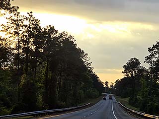
Headed west on I-10 through northern Florida and into the Deep South late in the day on May 4. |
|
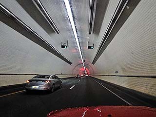
Passing through Mobile, Alabama - I-10 Tunnel. |
|
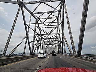
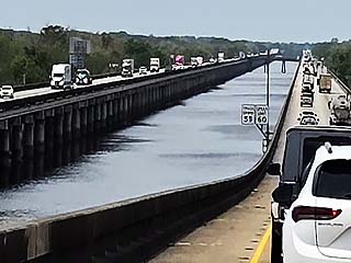
Crossing the Mississippi River. |
|
Heading out via I-10 west through the deep south from May 4 and 5, 2024. |
|
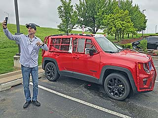
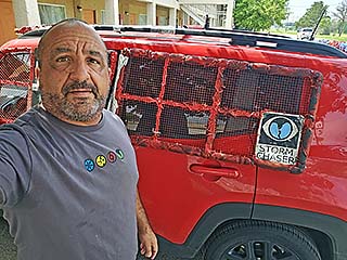
Vehicle prepared for the chase trip upon final arrival into Oklahoma on May 5-6, 2024. People often are interested in seeing storm chasers and their vehicles. |

|
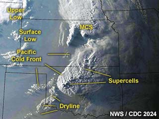
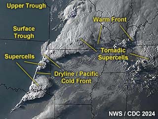
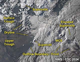
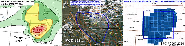
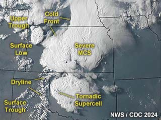
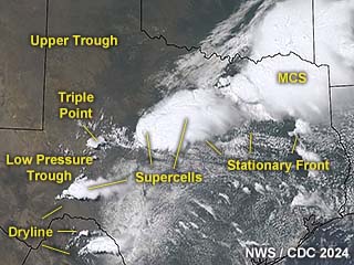
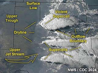
Annotated visible satellite (from around 1z on May 7) showing the synoptic environment and storm evolution over the central USA on May 6, 2024. |
|
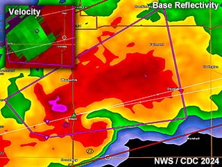
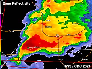
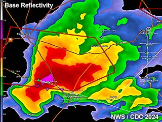
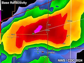
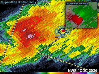
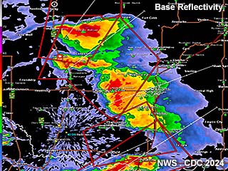
Radar imagery, showing base reflectivity, at around 7 PM CDT southeast of Okeene, Oklahoma on May 6. The supercell has an HP look on radar with a pronounced hook and BWER (bounded weak echo region). The intense velocity is to the upper-left inset. |
|
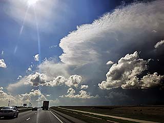
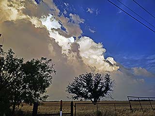
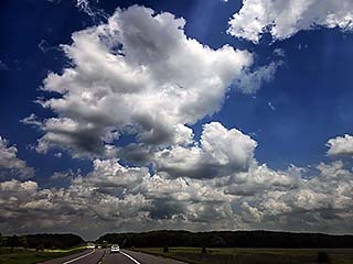
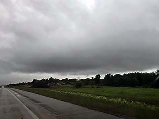
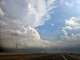
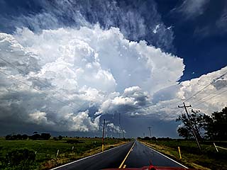
Convective initiation looking west from east of Clinton, Oklahoma during the afternoon of May 6, 2024. |
|
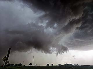
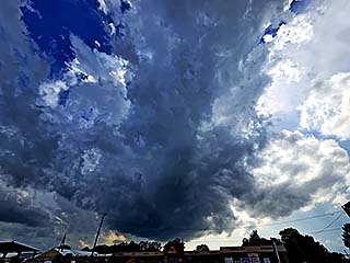
Wall cloud on intensifying supercell north of Clinton, Oklahoma. The view is to the northwest. |
|
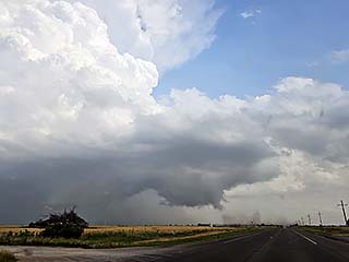
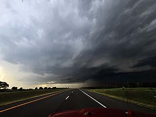
Storm intensifies and moves northeastward into Dewey County. The view is to the northwest. |
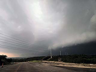
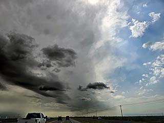
|
Wider view of now tornado-warned storm approaching Okeene, Oklahoma in Dewey county. The view is to the WNW. |
|
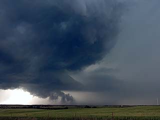
Rotating wall cloud. View is to WNW. |
|
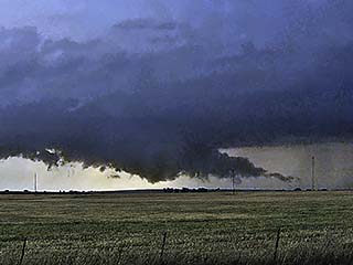
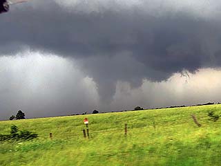
Funnel cloud / developing tornado near Okeene in Blaine County, Oklahoma during the afternoon of May 6. The view is to the northwest. |
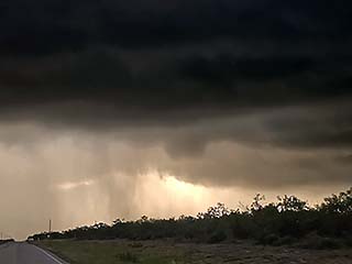
|
Tornado warned storm near Okeene, Oklahoma. The view is to the north. Possible rain-wrapped tornado in the HP phase of the storm at this time. |
|
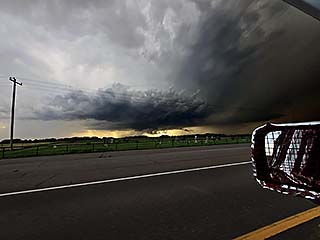
Powerful RFD winds on south side of tornadic circulation with HP storm near Okeene. I decided not to head north into the circulation. |
|
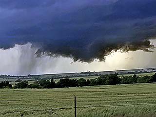
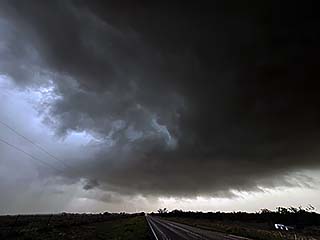
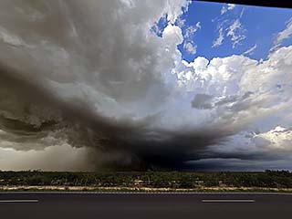
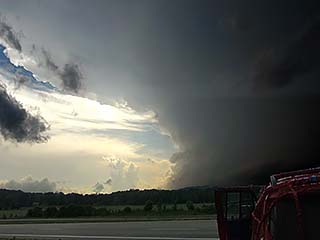
View of storm approaching I-35 corridor. Storm still had rain-wrapped tornado at the time, and is clearly in HP mode. The view is NNW. Later on, this same storm would cause damage after dark near Barnsdale, Oklahoma. |
|
Gust-front and "whales mouth" of outflow dominant storm off I-35. The view is to the south. |
|
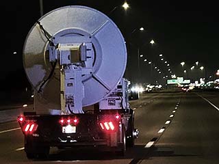
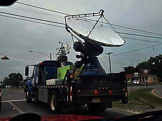
One of the DOW (Doppler on Wheels) research vehicles headed back to base while on I-35 south near Moore, Oklahoma during the evening of May 6. |
|
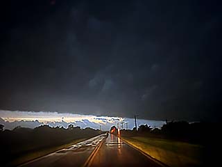
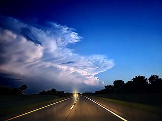
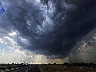
Powerful winds associated with a tornado-warned bow segment pass through Moore, Oklahoma during the late evening. These are straight-line winds, and not associated with any tornadoes. |
|
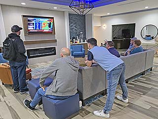
MCS pushes through Moore just before 11 PM CDT. Frightened hotel guests watch the TV and weather reports despite most of the danger passing. Winds gusted over 70 MPH with passage of the bow segment. |

|
May 7 was a down-day (any storms distant). I worked full-time at my remote IT job from my hotel (usually when I am chasing and theres no storms, I try to get work in during the week). |
|
Annotated visible satellite (from around 0z on May 9) showing the synoptic environment and storm evolution over the central / Midwest USA on May 8, 2024. |
|
Radar imagery, showing base reflectivity, at around 8:30 PM CDT near Shady Point, Oklahoma on May 8. The supercell has an classic look on base-reflectivity radar. |
|
Truck blows out a tire while heading east to the target area on I-40 east of Shawnee, Oklahoma during the afternoon of May 8. |
|
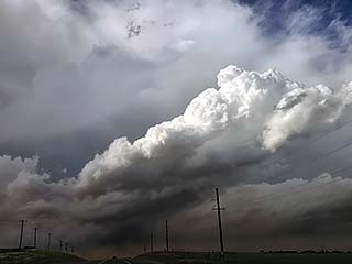
View of tail-end of storm complex initiating near Adair County, Oklahoma looking north on Highway 59. |
|
Closer view of developing supercell on south end of a line-segment west of Watts, Oklahoma. The view is to the WNW. |
|
Storm is outflow dominant, and a gust-front pushes into Adair County, Oklahoma. The view is to the northwest. |
|
Core of storm passes by, with some hail as large as 1". Note the green tint to the sky. This was south of Watts, Oklahoma. |
|
Another view in Adair County near Watts as hail core passes to the east. |

|
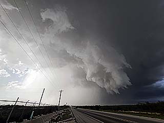
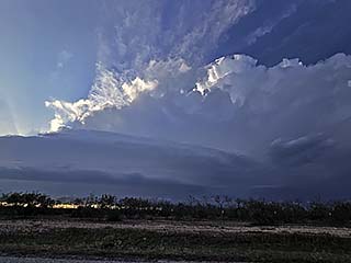
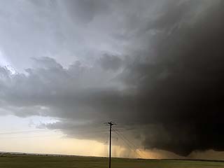
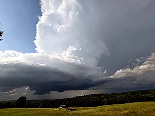
View of a supercell storm near Shady Point, Oklahoma at dusk on May 8. Note the wall cloud (lower-center) and a pronounced inflow "beaver's tail" feature extending to the right. The view is to the northwest. |
|
View looking north on the Shady Point supercell towards the hail core before abandoning the storm and headed south. |

|
Annotated visible satellite (from 22z) showing the synoptic environment and storm evolution over the south central USA (Texas) on May 9, 2024. |
|
Radar imagery, showing base reflectivity, at around 5PM CDT over Bosque County in central Texas on May 9. |
|
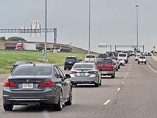
It's not easy passing trough, let alone getting out of the Dallas / Fort Worth "Metroplex"! |
|
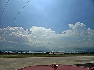
Approaching some supercell storms south of Weatherford, Texas. |
|
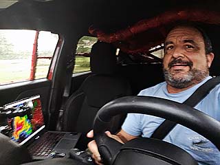
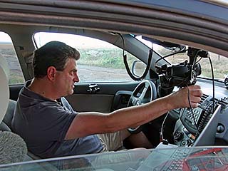
Myself driving, and closing in on a supercell storm near Bosque County, Texas. |
|
View of outflow-dominant supercell near Bosque County in central Texas on May 9. The view is to the southwest. |
|
Strong winds and hail as the core of the Bosque County storm passes my location. |
|
View of sky to the west as storms weaken near Waco, Texas. |
|
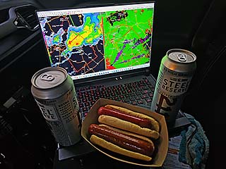
Sometimes, after a long drive, and settling in to my hotel after a chase – THIS is my dinner. Gas station hot dogs off the roller grill, and my favorite high-gravity lager to wash it down (usually in a watch box too)! |

|
The period from May 10-11 was down time spent in the northern part of Dallas. In this picture, from the late night of May 10 to early morning of May 11, the night sky northwest of Sherman, Texas glows rainbow (with prominent pink) as an extremely rare aurora (northern lights) occurred during a major solar storm. Auroras, normally confined to Canada and the far northern USA in North America - Were visible as far south as Florida and Mexico! |
|
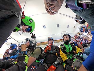
Skydiving at Skydive Dallas during the early afternoon of May 11. |
|
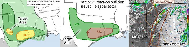
Annotated visible satellite (from around 0z on May 13) showing the synoptic environment and storm evolution over much of Texas on May 12, 2024. |

|
Radar imagery, showing base reflectivity, at around 7 PM CDT near Green County, Texas on May 12. The supercell is slightly elevated but has a good presentation on base-reflectivity radar. The velocity is in the upper-right inset. |
|
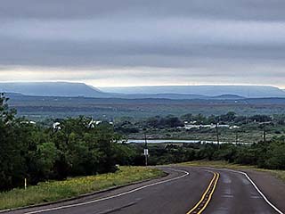
Heading west towards the target area, with the cap-rock of the Permian Basin over the horizon during the afternoon of May 12. |
|
Convective development on the western side of a cool-pool of outflow air over the Permian Basin in west-central Texas. The view is to the NNW - Can you discern the "shear" in the atmosphere? |
|
Approaching an elevated supercell storm near Green County, Texas. The view is to the west. |
|
Dark updraft base and developing storm near Green County, Texas. The storm is elevated above a shallow, stable cool-pool layer. The view is to the west. |
|
View of developing RFD and rotation with a slightly elevated supercell storm in Green County, Texas. The view is to the northwest. |
|
View of a slightly elevated supercell storm in Green County, Texas late in the day on May 12. The RFD can be seen wrapping from left to right, with mesocyclone clearly visible and a truncated funnel, center. The view is to the WNW. |
|
Same elevated storm as above, with RFD occlusion and rain wrap. |
|
Storms weaken and head east atop a stable cool-pool layer in the late afternoon sunlight. |
|
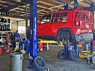
The period from May 13 to 15 was a more down time. I worked full-time at my remote IT job from my hotel in Lubbock. In this picture, I am getting much needed vehicle maintenance, including four new tires installed. |
|
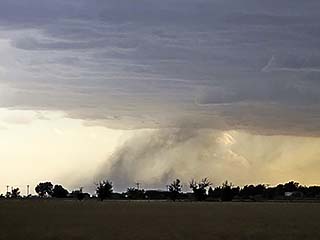
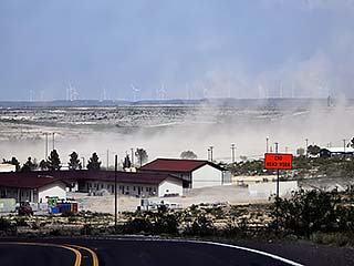
View of mini "haboob" as outflow from high-based, marginally severe storms kicks up dust west of Littlefield, Texas during the early evening of May 15. |
|
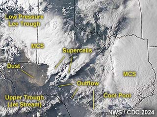
Annotated visible satellite (from around 0z on May 17) showing the synoptic environment and storm evolution over much of Texas on May 16, 2024. Note the "haboob" dust plumes, kicked up by severe outflow winds, near SW Texas! |
|
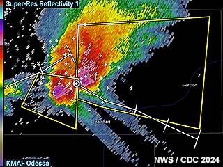
Radar imagery, showing high-resolution base reflectivity, at just before 6 PM CDT near Irion County, Texas on May 16. Note the impressive hail cores associated with a splitting supercell, with two hail "spikes" extending to the southeast! |
|
Approaching target area. This is the view looking southwest towards Midland, Texas as storms begin to fire during the afternoon of May 16. |
|
Dust gets kicked up northwest of Rankin, Texas in Upton County as storm begin moving east and southeast of the area. |
|
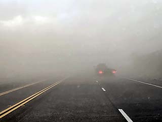
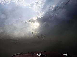
Low visibility in dust east of Rankin, Texas while heading east on Highway 67. |
|
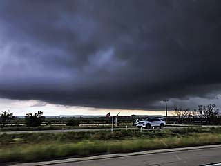
Supercell storm organizing northwest of Barnhart, Texas while heading east on Highway 67. The view is to the north and northeast. |
|
Wide view of supercell storm north and northwest of Barnhart, Texas. |
|
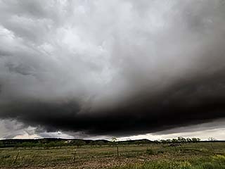
View of a powerful RFD with hail core (center-left), and wall cloud (right) just north of Barnhart, Texas late in the day on May 16. The view is to the north. |
|
Powerful inflow into the storm east of Upton County, as the low-level jet ramps up in the evening. |
|
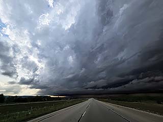
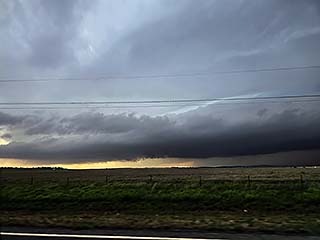
Supercell storm occludes and begins to evolve to a line / bow segment as is gets east to near Menard County. The view is to the north. |
|
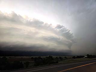
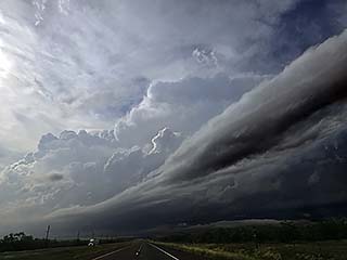
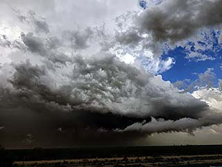
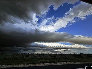
Bow segment and incredible storm structure near Menard County before dusk. The view is to the WNW. |
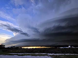
|
Another view of the bow segment / severe MCS and striated shelf cloud structure near Menard County, Texas before dusk on May 16. The view is to the southwest. |
|
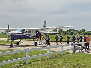
May 17 to 18 was down time spent back in the Dallas Area before heading north for more storm activity. In this picture, I am skydiving from 18,000 feet MSL and we are breathing oxygen. |
|
Annotated visible satellite (from around 0z on May 20) showing the synoptic environment and storm evolution over much of Kansas and Oklahoma on May 18, 2024. A powerful tornadic supercell is moving across western Oklahoma at this time. |
|
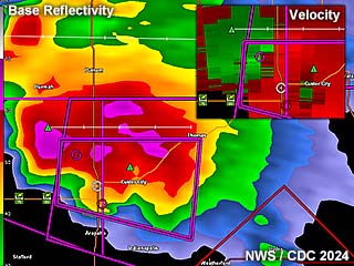
Radar base-reflectivity image at around 7:30 PM CDT over Custer County, Oklahoma on May 19. A large tornado was being produced at this time. The velocity is in the inset to the upper-right. |
|
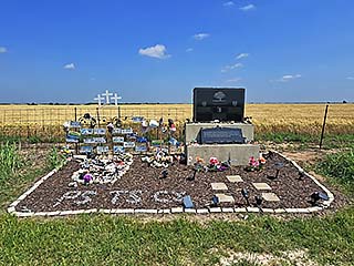
Visiting the memorial during the morning of May 19, 2024. This memorial is for Tim and Paul Samaras, and Carl Young, who were killed in 2013 from the El Reno tornado. This is off Radio road and south of I-40. |
|
Developing storms, that will eventually become a powerful supercell storm, near Canadian, Texas during the afternoon of May 19. The view is to the southwest. The storms are mainly high-based and producing hail at the time, as they did not yet move into the better moisture to the east after initiation. |
|
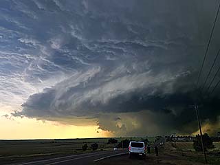
Powerful supercell about an hour later to the northwest of Roll, Oklahoma. The storm has already tapped into the better surface moisture and exhibits a striking visual structure as a chase tour group watches in the foreground. The view is to the west. |
|
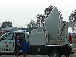
Doppler on Wheels (DOW from Oklahoma University) deployed ahead of the storm near Roll, Oklahoma. |
|
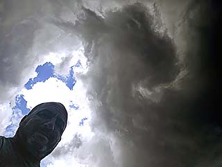
A funnel forms directly above me as the storm goes into HP mode, and I am in the rain-free "bear's cage" area northeast of Roll, Oklahoma. The view is looking straight up. |
|
Developing, low contrast tornado, looking northwest of SR 33 near Butler, Oklahoma. Dr Bill Hark is the chase to the lower right. |
|
View approaching the HP "notch" of the storm as it passes northeast of Butler. The view is to the north along Highway 183 and southwest of Custer City, Oklahoma. Wet RFD is from left to right, the goal is to penetrate this narrow "hook" (hook slice) and get into the rain-free area (Bear's cage) in order to get a view of any tornadoes, which should be still west of the highway. |
|
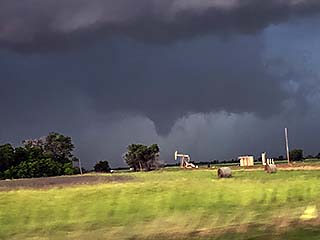
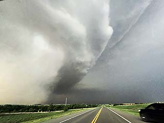
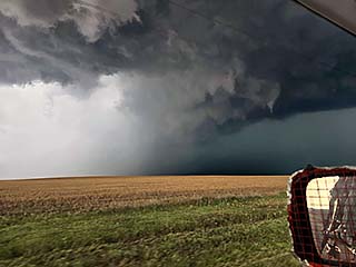
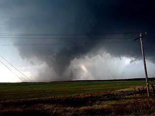
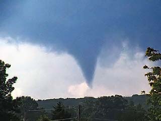
Once north of the narrow hook of rain and hail, I am offered this view of the left edge of a developing wedge tornado looking west from Highway 183 west of Custer City and northeast of Butler. |
|
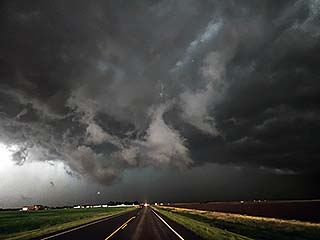
View looking west off Highway 183 towards Butler, Oklahoma and west of Custer City of a fully developed wedge tornado tearing across the Great Plains. The view is to the west. |
|
Large tornado becomes rain-wrapped and nearly stationary to my northwest as it slowly approaches and stalls near Highway 183 to my north. Reed Timmer passed me and will intercept the tornadic circulation a few minutes later. The view is north and northwest. |
|
Same storm later on as it moves to the east of Custer County and becomes HP and eventually a bow segment. |
|
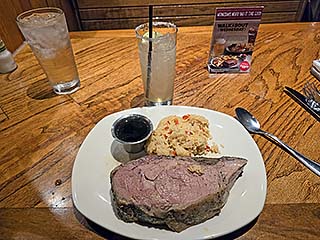
May 20 was an off day spent in Wichita, Kansas and I focused mainly on my main remote IT job. There were storms, but in far NE Colorado (mainly hail). Here I am enjoying a steak dinner after changing the oil on my vehicle. |
|
Annotated visible satellite (from around 20z on May 21) showing the synoptic environment and storm evolution over a large area stretching from Iowa through eastern Oklahoma on May 21, 2024. A tornado outbreak is also underway over Iowa at the time. |
|
Radar base-reflectivity image at around 5 PM CDT over Cherokee County, Kansas on May 21. The storm is within a broken line of supercells and has the classic shape on radar. |
|
Storms initiating on the south-end of the severe setup west of the Kansas / Missouri border during the afternoon of May 21. |
|
Wall cloud with rotating storm to the west and northwest of Cherokee, Oklahoma. The view is to the northwest. |
|
Possible brief tornado near Cherokee, Kansas and west of the KS / MO border during the afternoon of May 21. The view is to the northwest. |
|
Storms become more linear and outflow dominant as a Pacific Cold front and dryline surges east into extreme western Missouri. The view is to the north. |
|
View of distant cluster of strong and severe storms looking south from near the SE Oklahoma / NE Texas border late in the day / early evening. |
|
Annotated visible satellite (from around 1930z on May 22) showing the synoptic environment and storm evolution over much of Texas on May 22, 2024. |
|
Radar high resolution base-reflectivity image at around 11 AM CDT over Atoka County, Oklahoma on May 22. The storm was tornado warned, but elevated so there was no touch down. The velocity (impressive) is to the upper-right. |
|
Tornado-warned storm to the southwest of Atoka, Oklahoma during the late morning of May 22. The view is to the southwest. |
|
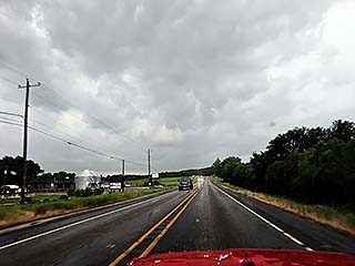
Storms firing to the south and southwest during the afternoon of May 22. |
|
Scientists also playing "catch-up", and unfortunately on the wrong storm like many of us. Some people saw a tornado way to the southwest - Congrats to them. |
|
Today I tried - But tomorrow is another day. Here I am wrapping up in Abilene, Texas for the evening. |
|
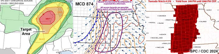
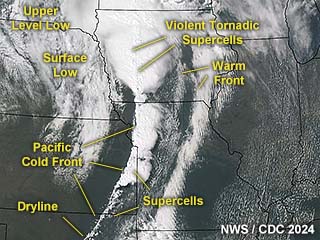
Annotated visible satellite (from around 0z on May 24) showing the synoptic environment and storm evolution over much of Texas and Oklahoma on May 23, 2024. |
|
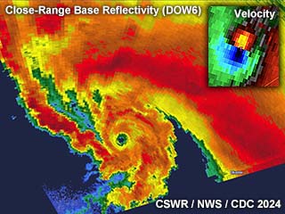
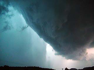
Radar ultra-high resolution base-reflectivity image (from CSWR Doppler on Wheels DOW6) at around 7:30 PM CDT near Jackson County, Oklahoma on May 23. The radar presentation is beyond breath-taking, with an incredible swirl and even an "eye" like feature in the tornado core. Winds measured were at nearly 95 M/S (210 MPH!), and the data-folded velocity from the NWS Doppler (Frederick, OK) is in the upper-right inset. |
|
Convective initiation along the dryline northwest of Childress, Texas begins during the afternoon of May 23, 2024. |
|
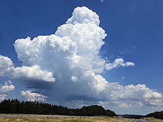
All "monsters" start out "small". LP stage of a supercell storm after initiation just west of Hollis, Oklahoma during the late afternoon. This is the start of a soon to be violent tornadic storm once it moves into better surface moisture to the east. |
|
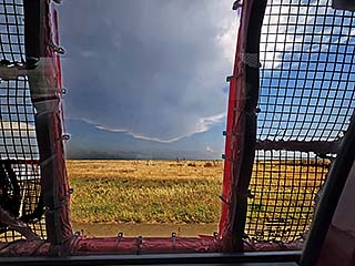
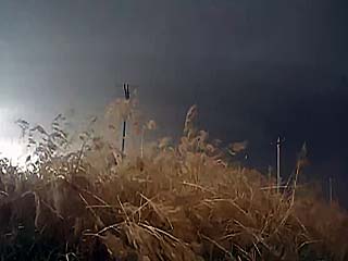
View to the east, through the passenger window hail guards, near Hollis, Oklahoma at the anvil blowoff ripping off to the east due to a powerful jet stream and strong wind aloft. Incredible difluence / divergence aloft (upper level support) allowing rapid intensification of supercell storms. Note the dust kicked up near the surface in strong SE winds! |
|
Dan Shaw from Australia watching the storm developing east of Hollis, Oklahoma. |
|
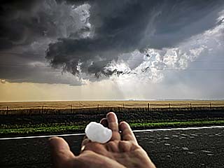
Rotating wall cloud with funnel developing, as a quarter-sized hailstone is picked up off the ground north of Gould, Oklahoma. |
|
Funnel and cloud "swirl" directly above me, with clear RFD region north of Gould, Oklahoma. |
|
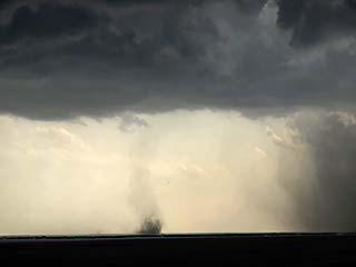
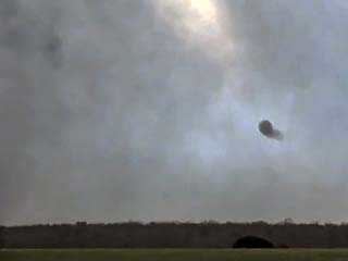
Land-spout tornado southwest of Gould, Oklahoma. The view is to the southwest. |
|
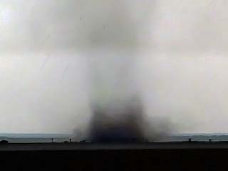
Close-up of the land-spout tornado showing dust / debris cloud southwest of Gould, Oklahoma. |
|
Storm cycles with new mesocyclone forming as it reaches better moisture axis and begins to rapidly intensify between Gould and ElDorado. |
|
Inflow into the intensifying storm was as high as 80 MPH at times! Dust is kicked up as the storm approaches ElDorado, Oklahoma at around 7 PM CDT. |
|
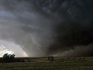
Storm starts producing large tornadoes with powerful inflow northwest of ElDorado, Oklahoma. The view is to the west. |
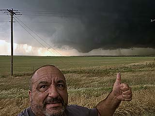
|
Myself giving a thumbs-up as tornado-genesis occurs north of ElDorado. Yes it was WINDY here! |
|
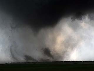
Mature stage of tornado, enters complex, multi-vortex stage. The view is to the west. |
|
Close-up view of multi-vortex tornado. Violent motion. The view is to the west. |

|
360 VR camera atop weighted base deployed on the side of the road and left as tornado passes. |
|
Unfortunately the VR camera battery failed, as well as the tornado turning from a due-east path to NNE and missing the camera. |
|
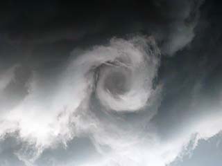
Internal sub-vortex with other vortices rotating around it. The view is to the west and WNW. |
|
Incredible horizontal vortices were observed on the edge of the tornado core-flow during the multi-vortex stage. The dreaded "dead man walking" effect. The view is to the WNW. |
|
Powerful RFD cut and massive low-level mesocyclone as the storm passes the roadway and stalls west of Oustee, Oklahoma. The view is to the north. |
|
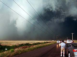
Incredible view of the now violent tornado, lower right, with full occlusion and supercell rear-flank (note the powerful RFD slot from the left to center) looking to the north and northeast on SR 34 northeast of ElDorado, Oklahoma. |
|
Close up of tornado, now looking to the northeast, with a lightning bolt behind it! |
|
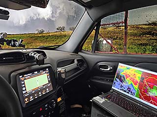
View of the inside of my chase vehicle, equipment, and large tornado on-going to my northeast! |
|
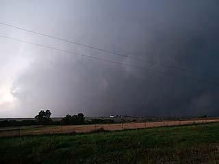
Supercell becomes HP as it approaches Oustee, Oklahoma - Fortunately no longer tornadic. The intense low-level jet is streaming left to right in this picture. The view is to the west. |
|
HP storm between Oustee and Altus, Oklahoma as dusk approaches. The view is to the north. |
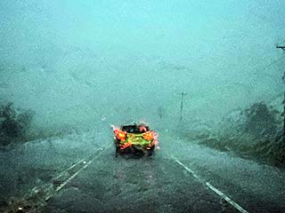
|
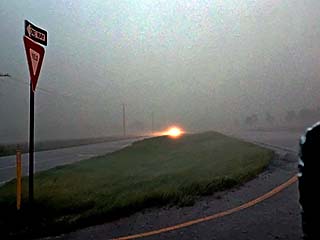
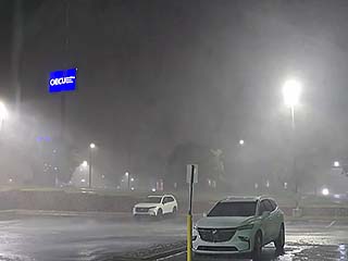
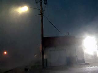
Horizontal rain and hail, driven by 70+ MPH winds, whip through Altus, Oklahoma after dusk. |
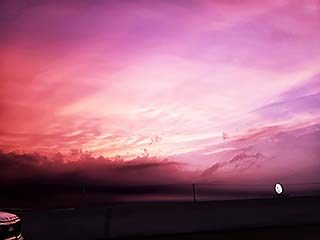
|
View of dusk sky after sunset, and heading north, safely behind the storms. The only thing I want to point out is the "look" of the clouds, especially the tower going up and being sheared apart and tilted (middle left to center). This shows the incredible amount of wind shear aloft, with a powerful jet stream directly overhead (125+ knots at FL340 from WSW), directional shear (surface was 30+ knots nearly opposite from SE), and di-fluent flow aloft. |
|
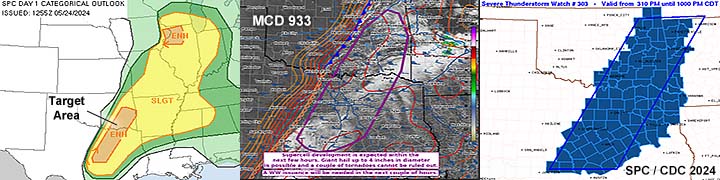
Annotated visible satellite (from around 23z) showing the synoptic environment and storm evolution over much of eastern Texas and SE Oklahoma on May 24, 2024. |
|
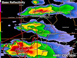
Radar base-reflectivity image at around 5:30 PM CDT from Cooke County, Texas to Marshall County, Oklahoma on May 24. A line of supercells has formed, producing large hail. |
|
Approaching target area near Marshall County, Oklahoma on May 24. The sky grows increasingly convective during the afternoon. The view is to the west and southwest. |
|
Supercell storms fire near Marshall County, Oklahoma with powerful updrafts. The view is to the southwest. |
|
View of a tornado-warned supercell storm in Cooke County, Texas near Callisburg. Visibility was poor due to haze. The view is to the west. |
|
Brief funnel cloud associated with one of the supercell storms north of the Red River in Oklahoma. The view is to the north. |
|
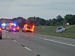
Accident on I-35 northbound south of the Oklahoma City are during the evening of May 24. |
|
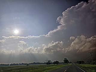
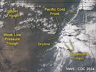
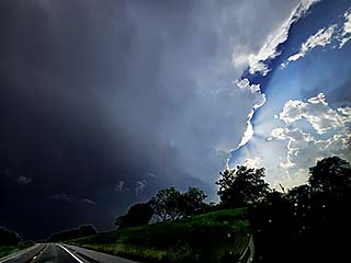
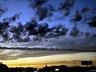
Increasing winds aloft and tell-tale sign of severe weather to come the following day during the evening of May 24. Note the alto-cumulus castellanus clouds as well. The view is to the north. The streaking of the clouds denotes a strong wind aloft approaching, like a jet stream. |
|
Annotated visible satellite (from around 23z) showing the synoptic environment and storm evolution over much of the southern Great Plains on May 25, 2024. |
|
Radar base-reflectivity image at around 4:45 PM CDT over southwestern Oklahoma on May 25. A cluster of severe storms stretches into Texas, with any tornado producing storms too far south and out of reach. |
|
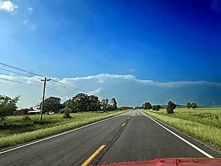
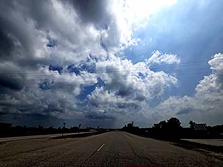
View looking southwest over north-central Oklahoma during the early afternoon of May 25. No storms yet, but a subtle reminder of what's to come is denoted by streaking high clouds aloft - Denoting the presence of a powerful jet stream / strong wind aloft. The position of the jet stream is important because certain types of storms develop underneath it - Especially tornadoes. |
|
Approaching the north side of a line-segment of severe storms near Roosevelt, Oklahoma on May 25. The view is SSE. |
|
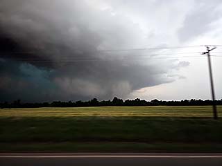
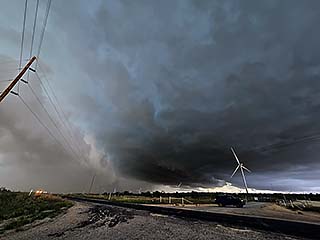
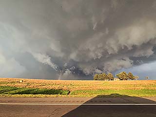
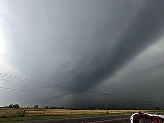
View of a supercell storm near Roosevelt, Oklahoma with rotating wall cloud, dust, and funnel before being under-cut by outflow. The view is to the southeast. |
|
Another view of the line-segment of severe storms east of Roosevelt, Oklahoma. |
|
Heading back north, and viewing the highly tilted and sheared storms over SW Oklahoma. The strong wind aloft tilts the updrafts causing the storms to "lean" left to right, looking northward, due to a powerful jet stream aloft. |
|
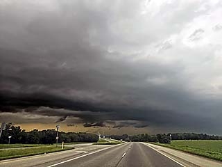
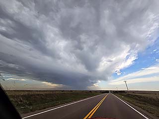
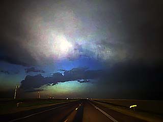
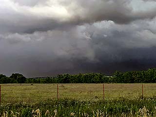
View of a post-tornadic storm near Seiling in Dewey County, Oklahoma. The view is to the west. |
|
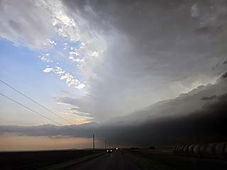
The Seiling, Oklahoma storm lines out and weakens late in the day on May 25. More tornadoes / severe storms would happen well after dark on this day. |
|
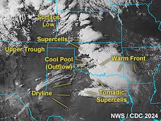
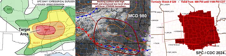
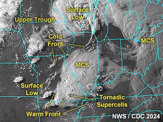
Annotated visible satellite (from around 1z on May 27) showing the complex synoptic environment and storm evolution over much of the Midwest, including the target area in Missouri on May 26, 2024. |
|
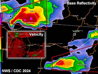
Radar base-reflectivity image at around 5 PM CDT over south-central to SE Missouri (Texas County) on May 26. Two developing tornadic supercells can be seen. The Doppler velocities are in the left inset. |
|
Convective initiation near Texas County, Missouri looking east along Highway 60 during the afternoon of May 26. |
|
Supercell storm initiating over Texas County, Missouri during the afternoon of May 26. This storm will eventually cause a powerful EF-3 tornado near Mountain View, Missouri to the east. |
|
Tornadic supercell moving towards Texas County, Missouri during the afternoon of May 26. The view is to the west, with anvil blow-off streaming overhead. |
|
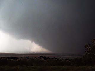
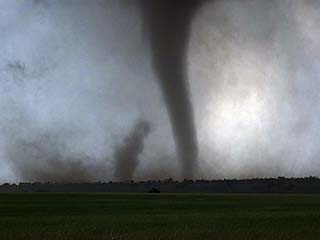
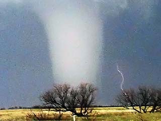
Classic supercell storm viewed from a hill-top southwest of Houston, Missouri during the afternoon of May 26. A tornado is on-going in this view to the northwest. |
|
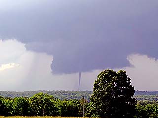
View of a tornado on the ground west of Houston, Missouri during the afternoon of May 26. The view is to the WNW during the cone stage of this tornado. |
|
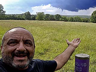
Myself with the Texas County, Missouri tornado in the background. What an AWESOME last chase day of this trip! |
|
Rope stage of the Texas County, Missouri tornado. Incredible view of the tornado and wall cloud. The view is to the northwest. |
|
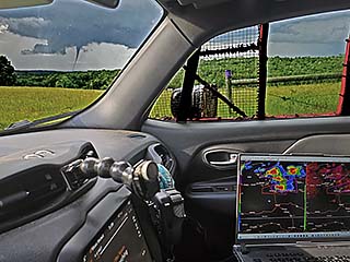
View of my vehicle interior with the Texas County, Missouri tornado in the background. |
|
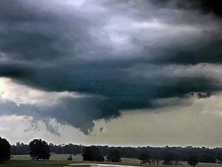
Late stages of the Mountain View, Missouri tornado looking east along Highway 60. |
|
Intense cycle, and UDI (updraft-downdraft interface) as another rain-wrapped tornado forms during the late HP stages of the Mountain View storm near dusk. |
|
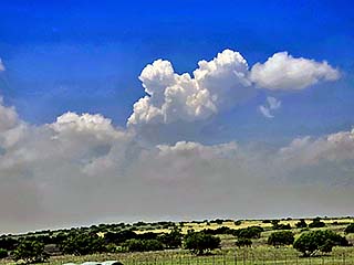
May 27 to 29 was strictly travel time heading back to south Florida and concluding this period of storm chasing. Here a rather benign cumulonimbus cloud breaches the sky northwest of Birmingham, Alabama on May 27. |
|
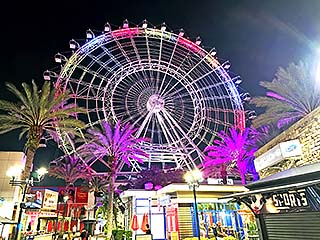
Stopped in Orlando, Florida during my leisurely return to south Florida - Taking in the sights of the attractions there. |
|
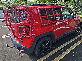
Hail guards and equipment put away in my garage after safely returning home on May 29. Until next time! |
|
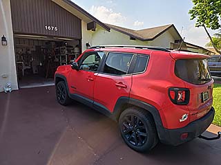
My chase vehicle, safe and sound, back at my residence in Deerfield Beach, Florida on May 29, 2024. |
HTML File "mwcl2024.htm" - Developed By Chris Collura
To Return To The HOME Page Of This Site Click The "INDEX.HTM" Link Here!