
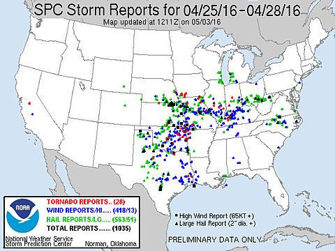
| This section is for storm chases done in the central / Midwestern United States during the year of 2016. This includes all storm chasing activities (including any major chase "expeditions") during the year of 2016 in the central USA (aka "Tornado Alley"). For 2016, all chases in the central USA will be logged in this section, with many of the chases being possible "spot" chases / major severe weather "setups" chased. Here you should find many pictures of lightning, tornadoes, hail, strong winds, along with many severe thunderstorm elements. Keep in mind that this chase log is scientific evidence and portrays my on-going storm chasing research. It has been placed on this page for easy reference and meteorological interests. Please do not plagiarize or copy this document to other sites for distribution. Note - This page may take a while to load on some SLOWER connections! |
STORM CHASING - CENTRAL UNITED STATES - 2016 CHASE LOG
| CHASER NAME | HOME / BASE CITY | CALLSIGN | CHASE DATES | OCCUPATION |
| CHRIS COLLURA | CHICAGO, IL | KG4PJN | 4-14 TO 4-17 | IT CONSULTANT |
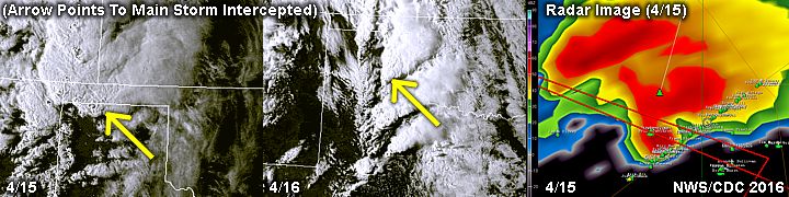
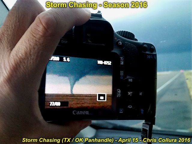
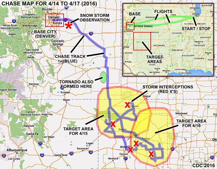
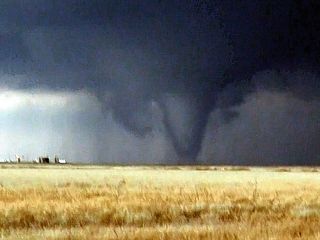
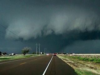
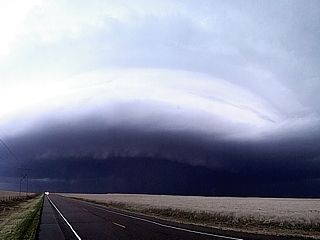
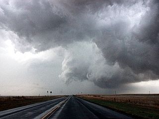
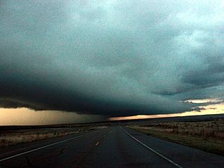
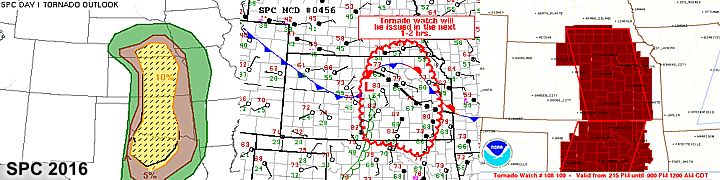
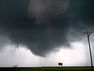
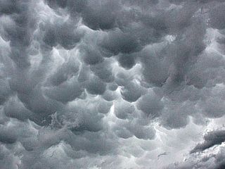
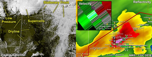
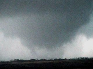
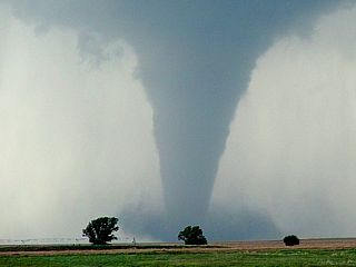
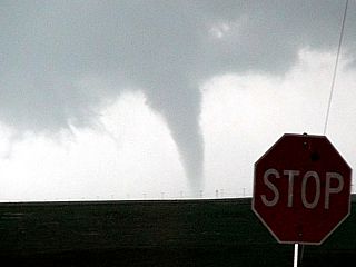
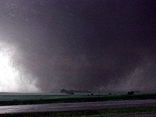
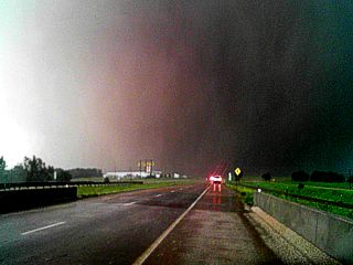
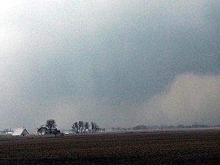
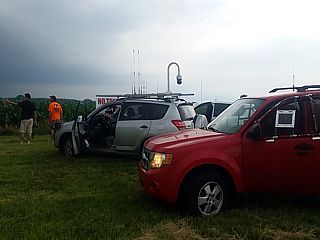
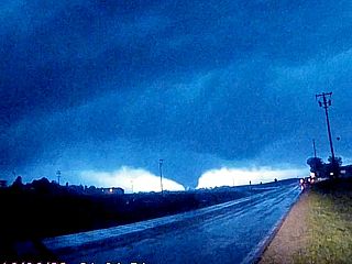
1). April 15, 8:00 PM - Interception and observation of an extremely severe and tornadic thunderstorm that paralleled Highway 54 and to its northwest from near Dalhart, Texas in Dallam and Hartley Counties and points northeastward as far as Hough, Oklahoma in Texas County. The storm was a cyclic classic to HP supercell storm. The core of the storm was not penetrated directly. At least 3 tornadoes were observed with this storm near Eva, Oklahoma in Texas County around 8 PM, CDT from along Highway 412. The first tornado was an elephant trunk, which lasted a few minutes. The second, forming just N of the first was a large stove-pipe tornado lasting about 5 minutes. The third west of the first two (that formed on the forward flank of the mesocyclone), was farther west and became a wedge tornado. This tornado quickly became rain wrapped and view of it was lost as the storm continued to the NE. Very heavy rains, hail to 1" (during indirectly penetrating the storm), lightning, and winds near 70 MPH were encountered as well. The storm inflow SE of the storm was at least 60 MPH, pulling dirt and dust off the ground near Stratford, and ingesting it into the storm main updraft prior to cyclic tornado genesis. The storm core had hail to baseball sized or larger. The storm had a striking visual appearance, with a "stacked plates" effect, inflow / beavers tail features, mammatus, and RFD clear slot. The storm remained over mainly rural areas, with damage being mainly to powerlines. The storm eventually continued NE after dark to the NW of Liberal, Kansas, before weakening and merging with a storm cluster. The storms were caused by a low pressure area, surface heating, strong upper level low, and advancing dryline. A 2016 Toyota Rav4 was used to chase the storms. Documentation was digital stills and HD video. A tornado watch was also valid for the area until 10 PM CDT.
2). April 15, 11:30 PM - Observation (from a fixed area) of a severe thunderstorm at a hotel in Dalhart, Texas (in Dallam County). This storm was the northern side of an intense supercell storm that passed just SE of my location (off Highway 54). The core of this storm had 60 MPH winds and golfball sized hail. Hail to 1" was observed at my location, with frequent lightning, torrential rains, and winds near 50 MPH. Conditions causing this storm were outflow boundaries, a low pressure area, nocturnal intensification of low-level jet, and upper level low. A 2016 Toyota Rav4 was used in chasing storms earlier, but was parked at the time. Documentation was HD video. A severe thunderstorm watch was also valid for the area until 5 AM CDT the following day.
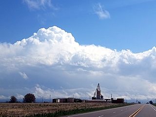
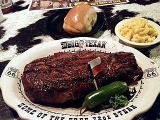
3). April 16, 1:30 PM - Observation (from a fixed area) of a strong thunderstorm at a restaurant off I-40 on the east side of Amarillo, Texas in Potter County. This storm was part of a developing cluster of strong and severe storms. Very heavy rains, lightning, 40 MPH winds, and copious amounts of marble (1/2") hail were observed with this storm. The sound on the metal roof / patio area of the restaurant (Big Texan) was deafening. Conditions causing these storms were an outflow boundary ahead of a developing dryline, a low pressure area, Pacific cold front, and upper level low. A 2016 Toyota Rav4 was used in chasing storms later this day, but was parked at the time. Documentation was audio.
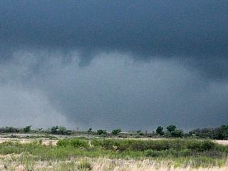
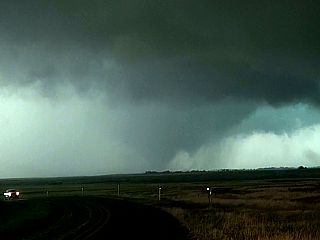
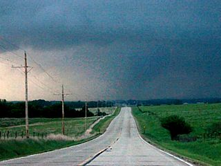
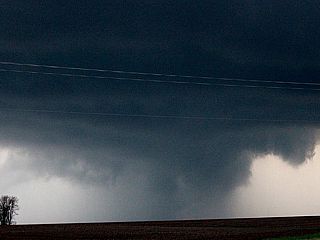
4). April 16, 5:00 PM - Observation of a strong to severe thunderstorm west of White Deer, Texas in Carson County from along Highway 207. The storm was a small supercell storm that developed a strong area of rotation (with rotating updraft, small funnel, and RFD clear slot). Heavy rains, 40 MPH winds, lightning, and small hail were also observed south of this storm. The storm became undercut by outflow and weakened afterwards. Conditions causing this storm were an outflow boundary (ahead of a stalled dryline), a low pressure area, Pacific cold front, and upper level low. A 2016 Toyota Rav4 was used to chase the storm. Documentation was digital stills and HD video. A tornado watch was also valid for the area until 9 PM CDT.
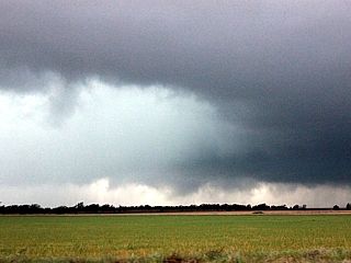
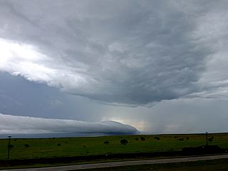
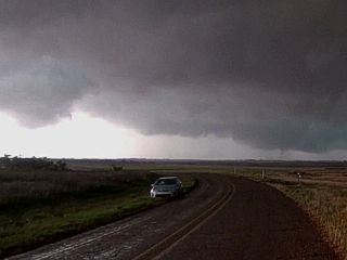
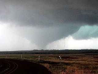
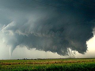
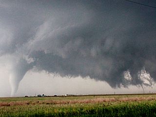
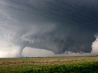
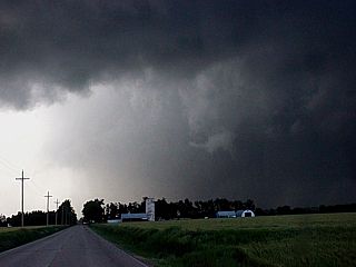
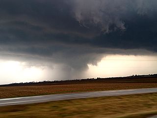
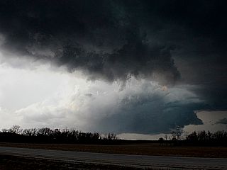
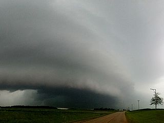
5). April 16, 6:30 PM - Interception and observation of a very severe and possibly tornadic thunderstorm from the south of Clarendon, Texas in Donley County along Highways 287 and 273 and near Lelia Lake and towards McLean. The storm was a classic to HP supercell storm, forming on the southern end of a line / cluster of strong and severe storms (the "tail-end Charley"). While passing west of Lelia Lake, the storm became very intense, with strong rotation, RFD wrap, and a possible brief tornado northwest of that location. The storm had a striking visual appearance, with well-developed RFD cut and rapidly rotating wall cloud. Winds near 60 MPH (mainly RFD), small hail, lightning, and heavy rains were encountered on the SE fringes of the storm. The storm moved north and eventually weakened north of McLean. The main core with golfball sized hail was not penetrated. Conditions causing this storm were an outflow boundary (ahead of a stalled dryline), a low pressure area, Pacific cold front, and upper level low. A 2016 Toyota Rav4 was used to chase the storm. Documentation was digital stills and HD video. A tornado watch was also valid for the area until 9 PM CDT.
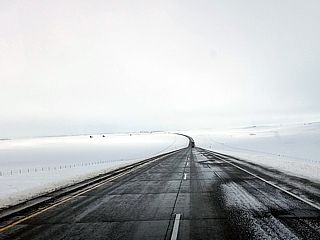
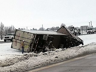
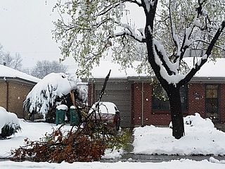
6). April 17, 12:00 PM - Observation of a winter storm and heavy snow from near Limon, Colorado and into Denver along I-70 and the east side of the Denver suburbs. This was due to a late-season winter storm, and some areas had snow totals exceeding 36 inches! In my areas, about 20 inches of snow was observed, especially towards Denver. Blowing a drifting snow was observed as well, with 40 MPH winds (ground blizzard) off I-70 near Byers and Cedar Point. Although this was the end of the winter storm, and roads were being cleared, some traffic accidents were observed. This was also a heavy wet snow, and weighted tree branches broke off and caused some damage as well / power outages. A 2016 Toyota Rav4 was used to observe these conditions, mainly en-route back to Denver from tornado chasing the past couple of days. Documentation was digital stills and HD video. A winter storm warning was also valid for this area.
This concludes the chase log for the central US Plains (including chases in Texas, Oklahoma, and Colorado) chase trip for April 14-17, 2016. The summary includes a total of 4 severe thunderstorms, 1 strong thunderstorm, and a winter storm. 4 tornadoes were observed from two of the severe storms. The main chase vehicle conducting this chase was a 2016 Toyota Rav4 SUV rental. This information was prepared exclusively for the National Weather service and the team of Skywarn storm spotters.
|
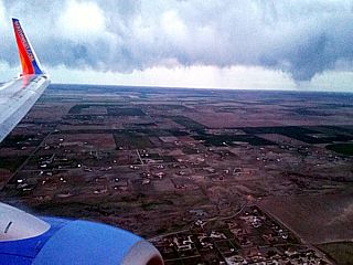
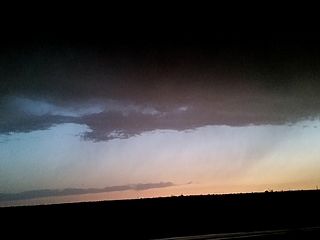
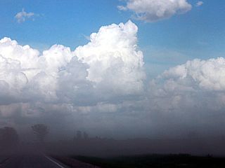
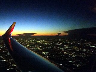
Coming into Denver late on April 14, 2016 and on a bumpy final approach. This is not a tornadic storm, but merely a line of clouds and scud-like lowerings associated with a cold front. |
|
Interesting cloud formations looming over Denver International Airport while landing on April 14, 2015. A sky like this normally means rapidly changing weather is on the way due to an intense upper-level system moving over the Rocky Mountains. |
|
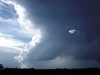
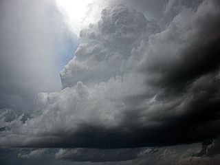
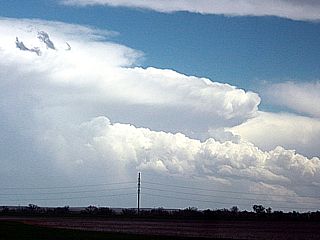
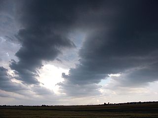
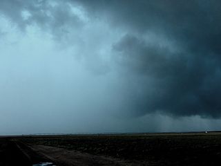
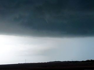
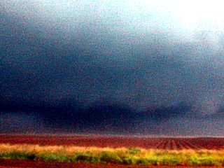
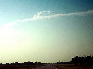
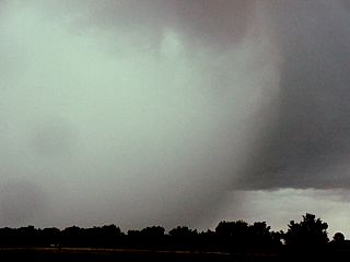
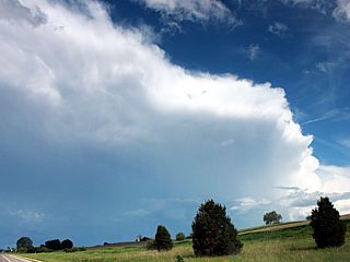
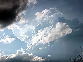
Initiation of storms (agitated cumulus and turbulent clouds as upper air support for severe storms arrives). This was to become the Eads, Colorado tornado-producing supercell on April 15. |
|
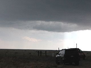
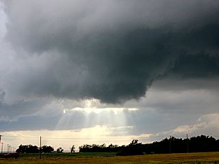
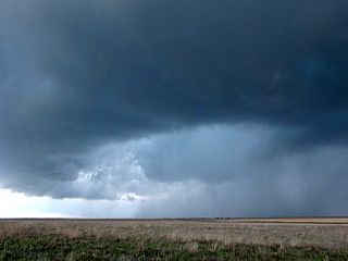
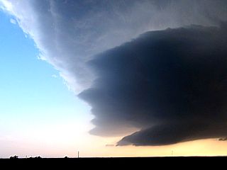
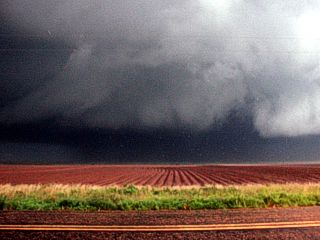
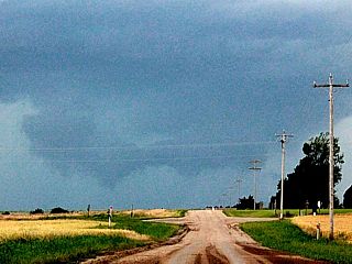
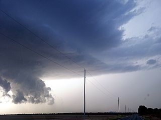
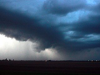
Developing mesocyclone southwest of Dalhart, Texas (with RFD cut). |
|
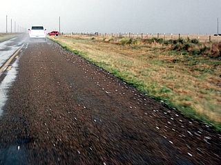
Hail on the ground near Stratford in N Texas Panhandle on April 15. |
|
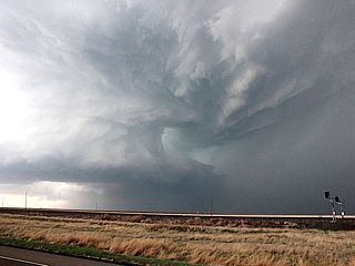
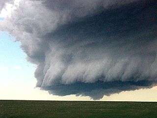
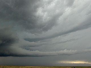
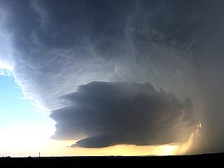
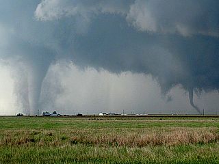
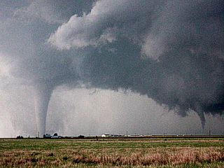
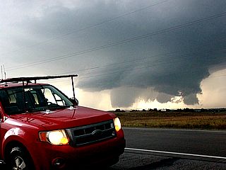
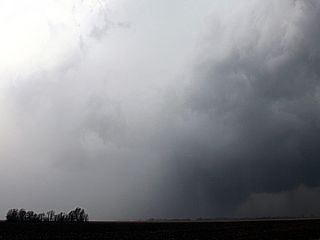
Texas County, Oklahoma tornadic supercell with powerful inflow on April 15. |
|
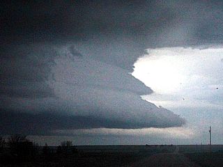
Texas County, Oklahoma tornadic supercell on April 15 shortly before re-intensifying and producing tornadoes. |
|
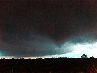
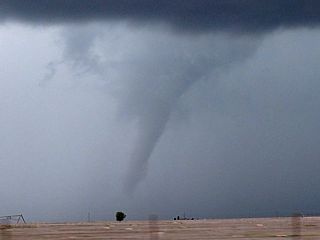
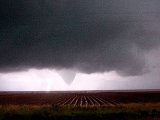
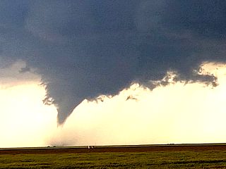
Funnel cloud on forward-flank of mesocyclone near Eva in Texas County, Oklahoma (tornado number 1 forming). |
|
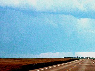
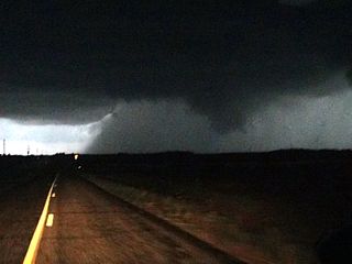
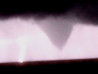
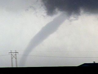
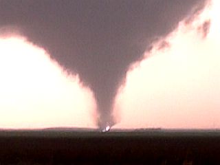
Tornado number 1 forms near Eva, Oklahoma in Texas County just before 8 PM central on April 15. |
|
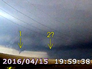
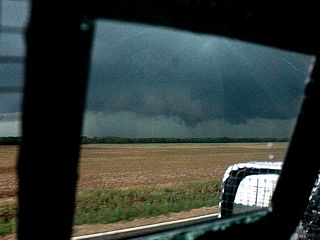
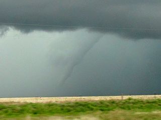
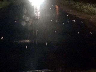
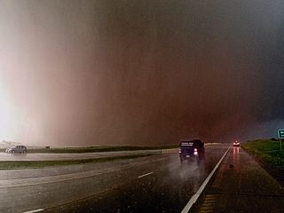
I am not sure if these are TWO tornadoes, obviously we have tornado number 1 to the left, and another rotating feature to the right of it near the precipitation core. This is from a video frame grab from my dash camera just before 8 PM CDT (April 15) southeast of Eva, Oklahoma in Texas County looking WSW off Highway 412. |
|
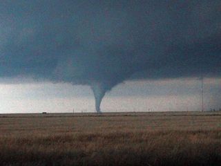
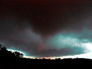
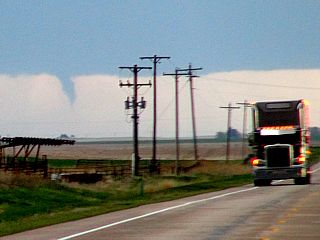
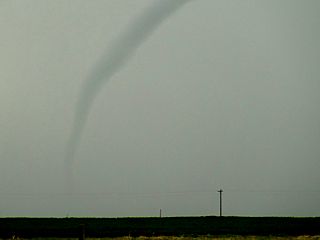
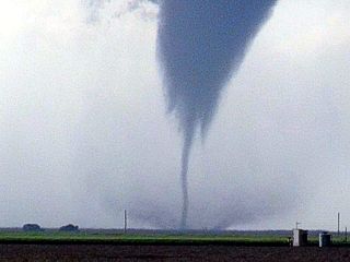
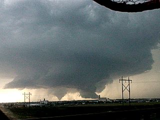
Large stovepipe tornado (number 2) forms near Eva, Oklahoma after the first one weakens. This is also on the forward-flank of the mesocyclone. These may actually be two vortices close together (binary / Fujiwhara interacting), with the weaker one to the left. |
|
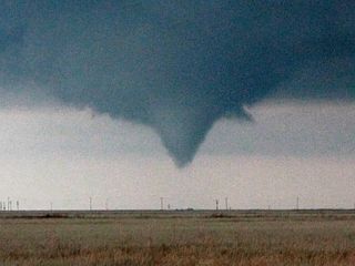
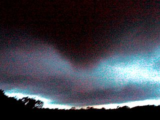
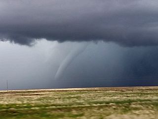
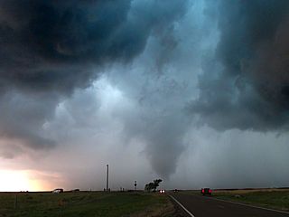
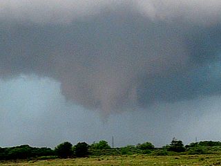
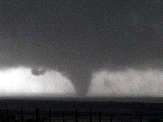
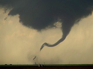
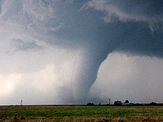
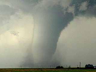
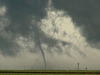
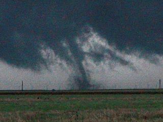
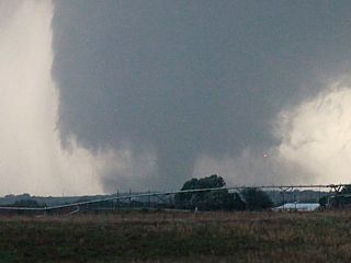
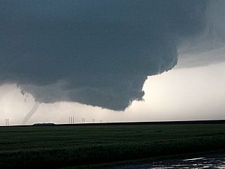
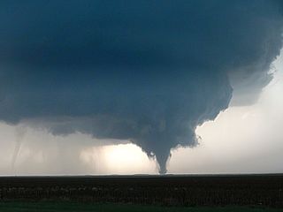
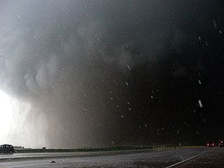
Wedge tornado forms under the main mesocyclone before becoming rain-wrapped south of Eva after 8 PM central on April 15. |
|
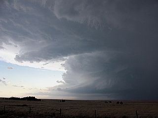
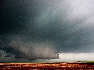
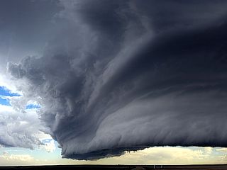
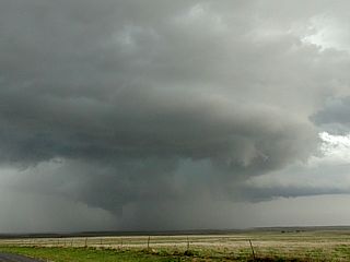
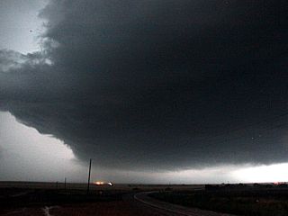
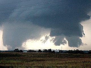
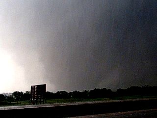
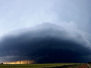
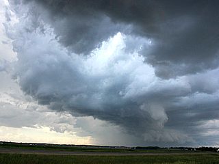
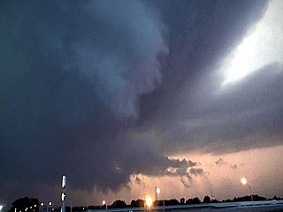
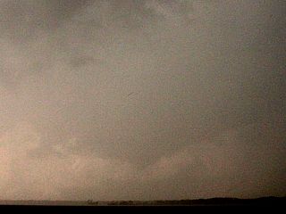
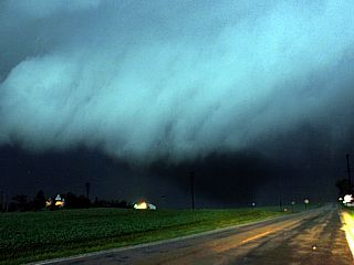
A wide view of the Texas County (Oklahoma) tornadic supercell on April 15 as it was still producing tornadoes (rain wrapped at this point). |
|
Development of strong to severe storms northeast of Amarillo, Texas near noon on April 16. |

|
Big Texan steakhouse in Amarillo, Texas. Better to celebrate a tornado intercept (from the prior day) by eating a big steak for lunch on another chase day! |
|
Celebration steak for lunch at Big Texan in Amarillo before chasing on April 16. |
|
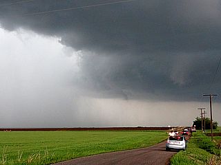
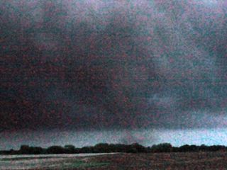
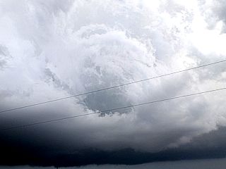
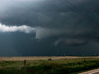
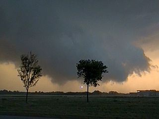
Mesocyclone (with funnel) and RFD cut from a small supercell storm just west of White Deer, TX. The view is to the north. |
|
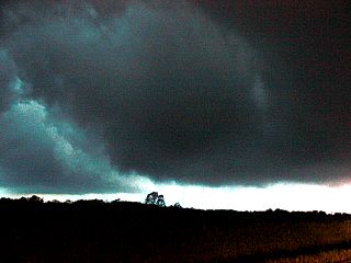
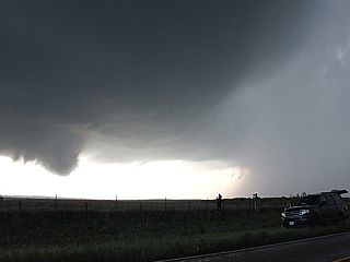
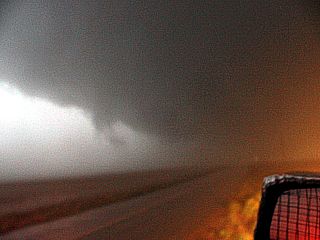
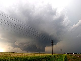
RFD clear slot and developing tornado NE of Clarendon, TX on April 16. |
|
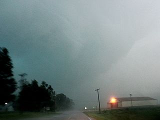
Possible tornado and rain wrap to the NE of Clarendon, TX. |
|
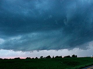
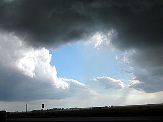
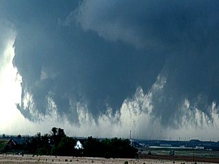
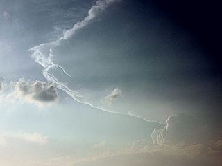
Line segment over NW TX Panhandle late on April 16. |
|
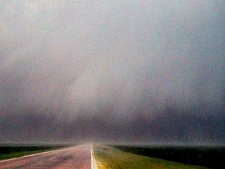
Dryline pushing into TX Panhandle near dusk on April 16. |
|
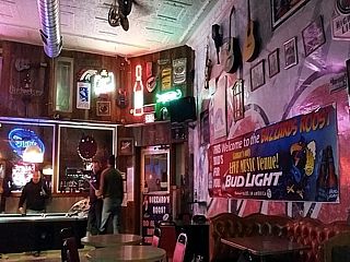
Stopping for quick drink at a local bar in Lamar, CO before spending the night there. |
|
Snow on I-70 west of Limon near Cedar Point, CO on April 17. |
|
Truck in median overturned on I-70 east of Denver. |
|
Branch falling from heavy wet snow west of Denver in the suburbs near Aurora. |
|
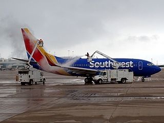
De icing of airplanes at Denver International Airport before flying out on April 17 to Chicago. I was VERY lucky my flight was not one of many cancelled. |
| CHASER NAME | HOME / BASE CITY | CALLSIGN | CHASE DATES | OCCUPATION |
| CHRIS COLLURA | CHICAGO, IL | KG4PJN | 4-25 TO 4-28 | IT CONSULTANT |
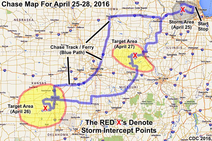
1). April 25, 5:00 PM - Observation of a strong to severe thunderstorm just east of I-39 near Rochelle and Esmond in Olga County, Illinois. The storm was a multicell thunderstorm and was observed while passing to its west while en-route on I-39 southbound. Some 50 MPH gusts, small hail, lightning, and moderate rain were encountered. A hail shaft was noted to the east. The storm also kicked up a large quantity of dust from the farmland. The storms were caused by surface heating, a frontal zone, and upper trough. Documentation was digital stills. A 2009 Ford Escape was used to observe the storms. A severe thunderstorm watch was also in effect for the area until 9 PM CDT.
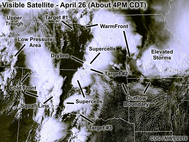
2). April 26, 4:00 PM - Interception and observation of a very severe and tornadic thunderstorm to the west of Wellington, Kansas (near Mayfield) in Sumner County from near highways 81 and 160 and points north to west of I-35 and the southwest side of Wichita. The storm was an HP supercell storm. Near Mayfield, a possible brief tornado was observed. The storm also had a large rotating wall cloud at times. Frequent lightning, 50 MPH winds, heavy to torrential rains, and hail exceeding 1" was encountered while observing this storm, although the main core was not penetrated. The storm moved north and evolved into a multicell cluster of strong and severe storms to the southwest of Wichita. Copious amounts of small hail and flash flooding was observed in those areas. The storms were caused by surface heating, a dryline, low pressure area, and strong upper trough. Documentation was digital stills, audio, and HD video. A 2009 Ford Escape was used to observe the storms. A tornado watch was also in effect for the northern portions of the area until 9 PM CDT, with a PDS (particularly dangerous situation) tornado watch valid until 12 AM the next day 1n the southern area.
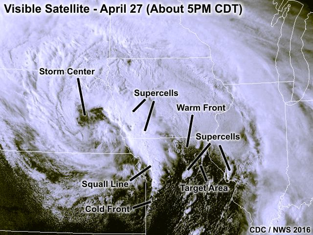
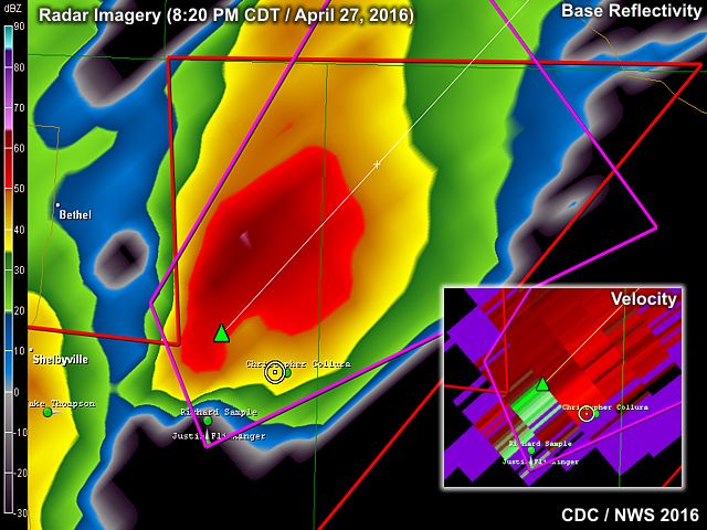
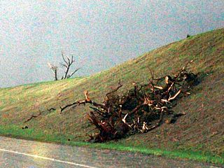
3). April 27, 8:00 PM - Observation and penetration of an extremely severe and tornadic thunderstorm in Shelby County, Missouri from near Shelbina on Highways 36, 15, and route 168 through Emden and points east. The storm was a small classic supercell storm, and produced a tornado that passed just south and east of Emden, Missouri just after dark at about 8:30 PM. The small rural town was spared, but numerous trees were snapped and some out buildings had structural damage (including a small church). No one was injured. As the tornado was observed southwest of Emden, a loud roar could be heard with the sound of trees "cracking" and "metal banging" as it neared the town. A large cone tornado appeared with an impressive RFD wrap visible in the waning daylight. Pressure could be felt in the ears. The core of this storm was also penetrated, and contained frequent lightning with some close hits, torrential rains, and at least quarter sized (1") hail. The strongest winds observed were about 65 MPH, mainly RFD after the tornado passed. The storm also produced large hail (many 1" stones) earlier south of Highway 36 during its LP phase. The storm was caused by surface heating, a warm front, upper trough, and strong low pressure area to the west (low level jet also increasing at dusk). Documentation was digital stills in low light. A 2009 Ford Escape was used to chase the storm. A tornado watch was also in effect for this area until 9 PM CDT.
This concludes the chase log for the central US Plains (including chases in Kansas and Missouri) chase trip for April 25-28, 2016. The summary includes a total of 3 severe thunderstorms. 2 tornadoes were observed from two of the severe storms. The main chase vehicle conducting this chase was a 2009 Ford Escape SUV. This information was prepared exclusively for the National Weather service and the team of Skywarn storm spotters.

|
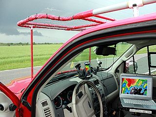
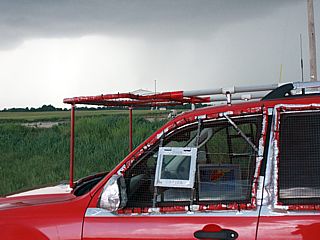
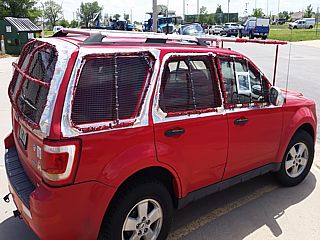
Here is a picture of myself and my Ford Escape chase vehicle with hail-guards installed late in the day on April 25, 2016. |
|
Multicell cluster of strong and severe thunderstorms east of I-39 near Rochelle, IL in Olga County on April 25. Although not a chase day, I still experienced some storms leaving the Chicago area. |
|
Hail shaft over Olga County, IL late on April 25 and west of I-39. |
|
My chase vehicle ready for the developing supercell on April 26 in Kansas. |
|
Large rotating wall cloud forming on supercell storm to the southwest of Wellington, Kansas on April 26. |
|
Funnel (or even a weak tornado forming) SW of Wellington, Kansas on April 26. |
|
Two funnels, with the one in the center a possible brief tornado on April 26, 2016 west of Mayfield, Kansas. |
|
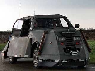
One of the "Dominator" tornado vehicles. This was West of Wellington, Kansas on April 26. |
|
Rotating wall cloud west of Mayfield, Kansas on April 26. |
|
Flash flooding southwest of Wichita, Kansas late on April 26. |
|
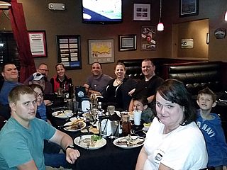
Chaser convergence dinner at Hangar One steakhouse in Wichita late on April 26. |
|
Developing LP supercell storm in Shelby County, Missouri late on April 27, 2016. |
|
Hail collected from farm road in Shelby County, MO on April 27. |
|
Another view of the LP supercell (before evolving to classic mode) in Shelby County, MO near Highway 36 late on April 27. |
|
Base of supercell storm before rapid intensification in Shelby County, Missouri late on April 27. |
|
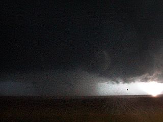
RFD cut and tornadogenesis SW of Emden, MO after dusk on April 27. |
|
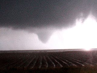
Tornado approaching Emden, MO (Shelby County) in very low light after dark on April 27. |
|
Develping tornado SW of Emden, MO (Shelby County) in very low light after dark on April 27. |
|
Tornado SW of Emden, MO (Shelby County) after dark on April 27. At this point you can hear trees snapping with a loud roar! |
|
Tornado (in VERY low light) moving NE and north of Emden, MO with debris cloud on ground. After dark on April 27 in Shelby County, MO. |
|
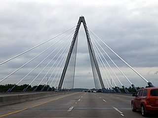
One of many bridges crossing back into Illinois and headed home late on April 27 and 28 (arriving back in Chicago early morning on the 28th). |
| CHASER NAME | HOME / BASE CITY | CALLSIGN | CHASE DATES | OCCUPATION |
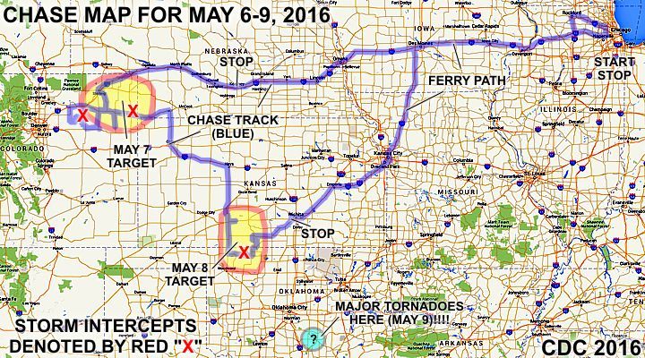
| CHRIS COLLURA | CHICAGO, IL | KG4PJN | 5-6 TO 5-9 | IT CONSULTANT |
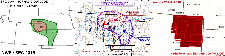

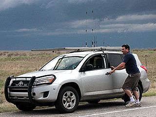
1). May 7, 4:30 PM - Observation and penetration of a severe thunderstorm from south of Wiggins and Fort Morgan, Colorado in Morgan and Washington counties from near Highways 34 and 71 and eastward to between Akron and Anton along Highway 63. The storm was a cluster of severe thunderstorms, with a supercell storm on the tail end (southern portion of the storm complex). These storms remained over open country, and produced some brief tornadoes and funnels as well (the tornadoes were not directly observed). Strong winds over 60 MPH, very heavy rains, frequent lightning, and golfball sized hail was also observed with these storms. The supercell storm along the line segment had a striking visual appearance and strong rotation. These storms were caused by upslope wind flow, a low pressure area, upper trough, and surface heating. Documentation was digital stills and HD video. A 2009 Ford Escape was used to observe the storms. A tornado watch was also in effect for portions of the area until 7 PM MDT.
2). May 7, 7:00 PM - Observation of an extremely severe and tornadic thunderstorm from near Yuma, Colorado along Highway 34, and into Wray near Morgan County. This storm was observed from a range of 20 to 30 miles at the most intense point, after abandoning the previous storm observed too long above. This was a classic cyclic supercell storm, producing more than 3 tornadoes, one of which struck the northern outskirts of Wray causing damage. These tornadoes were highly visible, and could be seen more than 30 miles away from the storm, especially looking east from near Yuma on Highway 34. At least two of the tornadoes from this storm were observed, despite being farther away (as myself and some storm chasers were also focusing on the cells to the west too long) from other storm chasers who were closer to this cell. The core was not penetrated. Rotating wall clouds and funnels persisted after the storm passed north of Wray and weakened. Damage was observed north of Wray on 385, and it was closed, ending the chase with fuel low. Conditions causing the storm were upslope wind flow, a low pressure area / dryline, upper trough, and surface heating. Documentation was digital stills and HD video. A 2009 Ford Escape was used to observe the storms. A tornado watch was also in effect for portions of the area until 7 PM MDT, later extended via a special MCD for this supercell.
3). May 8, 6:30 PM - Observation and indirect penetration of an very severe and possibly tornadic thunderstorm in Woods County, Oklahoma from near Highway 64 and 281. This storm was a classic supercell storm (which evolved from LP). Strong rotation with a wall cloud, funnels, and a powerful RFD were observed with this storm. A brief tornadic spin up / gustnado near the RFD impacted the chase vehicle (no damage), with blowing dirt and causing my ears to pop! The storm also contained large hail (1" was observed outside the main core), winds near 60 MPH (the gustnado had gusts over 70), frequent lightning, and very heavy rains. The storm was caused by surface heating, a dryline, upper trough, and low pressure area. Documentation was digital stills and HD video. A 2009 Ford Escape was used to chase the storm. A tornado watch was also in effect for this area until 9 PM CDT.
This concludes the chase log for the central US Plains (including chases in Kansas and Missouri) chase trip for May 6-9, 2016. The summary includes a total of 3 severe thunderstorms. At least 2 tornadoes were observed, possibly 3 from two of the severe storms. The main chase vehicle conducting this chase was a 2009 Ford Escape SUV. This information was prepared exclusively for the National Weather service and the team of Skywarn storm spotters.
|
Here is a picture of myself in front of my chase vehicle and ready to head out towards the primary target area after working on May 6, 2016. |
|
Another view of the front of my chase vehicle with hail-guards while on a supercell storm near Akron, Colorado on May 7. |
|
Mammatus clouds over Akron, Colorado on May 7. |
|
Daniel Shaw from Australia in his chase vehicle (he was chasing with Eric Treece) along Highway 34 in Colorado during the afternoon of May 7. |
|
Beautiful gust front pushing out of Washington County, Colorado as a cluster of storms becomes outflow dominant on May 7. |
|
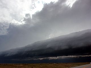
Tail-end "charley" LP supercell storm (with beautiful sculpted striations) on the southern end of a line segment of severe thunderstorms northwest of Anton, Colorado late in the day on May 7. |
|
Rotating portion, and small funnel, of the LP storm (with impressive structure) northwest of Anton, Colorado late on May 7. |
|
Interesting inflow banding just north of the LP storm, and near a cluster of severe storms to its north, near Anton, Colorado late on May 7. |
|
Meanwhile to the east and southeast towards Morgan County, a soon-to-be tornadic supercell develops south of Wray on May 7. |
|
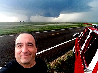
After bailing on the line segment and LP storms to the west, I rushed east along Highway 34 towards a tornadic supercell near Wray, Colorado during the evening of May 7. This storm produced highly visible tornadoes, and despite being 20 to 30 miles west of the supercell (unfortunately), they were still visible. In this picture, a stove-pipe (later rated EF-2) tornado is clearly visible just left of the roadway with a possible second tornado to the far left just lifting! |
|
Another view of the Wray, Colorado tornado, during its weakening phase, viewed from east of Yuma, Colorado at long-range on May 7. |
|
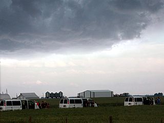
The next day, May 8, was a chase day in southern Kansas / northern Oklahoma. My vehicle is prepared for the chase during a major storm chaser convergence and fuel / lunch stop in Greensburg, Kansas. |
|
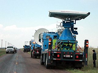
Many chase vehicles, including the Doppler on Wheels (DOW) trucks and the TWIRL (Tornadic Winds In-situ and Radar observation at Low levels) research team along a side street in Greensburg, Kansas on May 8. |
|
Storm chaser / structural engineer Tim Marshall with members of the TWIRL team and one of the DOW trucks in the background in Greensburg, Kansas on May 8. |
|
LP supercell developing west of Alva, Oklahoma during storm initiation along the dryline with my chase vehicle in the foreground along Highway 64 on May 8. |
|
Intensifying classic supercell storm beginning to split west of Alva, Oklahoma on May 8. |
|
Wider view of classic supercell storm near Alva, Oklahoma on May 8. Note the beaver's tail to the upper right in the photo. |

|
Rotating wall cloud associated with the supercell storm as it passes northeast of Alva, Oklahoma and intensifies late in the day on May 8. |
|
Inflow feeder bands curving into the southeast portion of the supercell storm to the northeast of Alva, Oklahoma on May 8. |
|
Rotating wall cloud / funnel on the supercell northeast of Alva, Oklahoma on May 8. An intense gustnado / RFD vortex of some sort impacted the chase vehicle just before this picture was taken and I repositioned. |
|
Rear-flank downdraft (RFD) clear slot with blue sky punching into the backside of the Alva, Oklahoma supercell just before splitting again and weakening on May 8. |
|
Three vans from one of the storm chasing tour groups observing the weakening supercell east of Alva, Oklahoma late on May 8. |
|
Unfortunately I could not chase on what turned out to be the BIG chase day, May 9 (down in S Oklahoma). I needed to head back for work in Chicago May 10, and that area was too far away. This is the bridge in Kansas City for I-35, crossing the Missouri river. |
| CHASER NAME | HOME / BASE CITY | CALLSIGN | CHASE DATES | OCCUPATION |
| CHRIS COLLURA | CHICAGO, IL | KG4PJN | 5-15 TO 5-17 | IT CONSULTANT |
| DEREK SIBLEY | HOLLYWOOD, FL | KG4PJN | 5-15 TO 5-17 | STUDENT / LIFEGUARD |
| MARK FARMER | NAPLES, FL | KG4PJN | 5-15 TO 5-17 | MANAGEMENT |
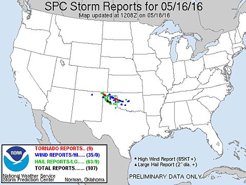
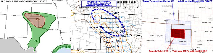
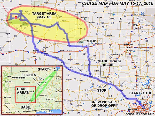
1). May 16, 5:00 PM - Observation and indirect penetration of an extremely severe and tornadic thunderstorm from near the Oklahoma / New Mexico border north of Highway 412 / 56 in Cimarron County near Wheeless, and east and southeast to near Highway 385 near Boise City and eventually east and southeast towards Stratford, Texas from along Highway 287. The storm was a powerful classic supercell storm that evolved to HP. This cyclic supercell storm produced at least three tornadoes, two of which were observed (one near Felt, Oklahoma and another along Highway 56 / 412 SW of Boise City). The first was a stovepipe that came out of the rain (looking NE from Highway 56 / 412) then evolved to elephant trunk and roped out after 10 minutes. The second was a cone tornado that lasted about 4 minutes southwest of our location during another storm cycle. The third was barely visible and rain wrapped west of Kerrick, Texas as the storm became highly HP. After that, the storm evolved to a bow segment and merged with an MCS (storm cluster) as it neared Stratford. The storm core was not directly penetrated, but had hail to baseball sized. Golfball sized hail was observed from our positions with this storm, which left some dents on the vehicle. The storm also contained torrential rains, 70 MPH wind gusts, and frequent lightning with some close hits. The storm also had a striking visual appearance with many inflow bands and striations. These storms were initiated by upslope wind flow and surface heating. They were sustained by a low pressure area, upper trough, stationary front, and advancing dryline (triple point). Documentation was digital stills, audio, and HD video. A 2016 Toyota Yaris was used to observe the storms. A severe thunderstorm and tornado watch were also in effect for the area until 10 PM CDT.
This concludes the chase log for the central US Plains (including chases in Oklahoma and Texas) chase trip for May 15-17, 2016. The summary includes a total of one severe thunderstorm. At least 2 tornadoes were observed, possibly 3 from this the severe storm. The main chase vehicle conducting this chase was a 2016 Toyota Yaris rental. This information was prepared exclusively for the National Weather service and the team of Skywarn storm spotters.
|
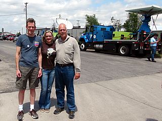
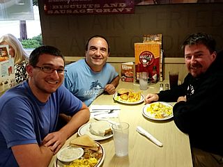
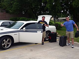
This is a picture of our chase group after I met up with them in Decatur, Texas on May 15 and we were staying that evening in Elk City, Oklahoma. From left to right is Derek Sibley, myself, and Mark Farmer. |
|
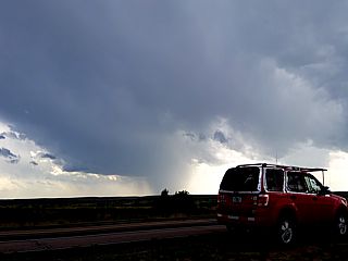
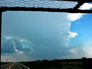
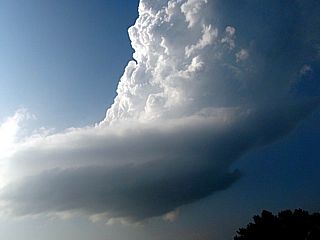
A severe storm, with overspreading anvil, can be seen west of Cimarron County, Oklahoma and over New Mexico / Colorado during the afternoon of May 16. This was to become the main (and tornadic) supercell of the day. |
|
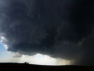
Rapidly intensifying supercell storm comes into better view out of New Mexico and into Oklahoma west of Cimarron County during the afternoon of May 16. |
|
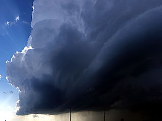
Amazing inflow banding and beavers tail features associated with the intensifying supercell storm west of Cimarron County, Oklahoma on May 16. |
|
Rapidly wrapping RFD and mesocyclone intensification as the supercell storm continues moving east and southeast west of the OK / NM border in Cimarron County on May 16. |
|
Initial development of the soon to be Felt, Oklahoma tornado, looking northeast from just north of Highway 56 / 412 and east of the OK / NM border on May 16. This feature was seen wrapping up, intensifying, then becoming visually lost in the rain. |
|
Continuing northeast on Highway 56 / 412 and near Felt, Oklahoma, a large stove pipe tornado emerges from the rain wrap around 5 PM CDT on May 16. |
|
Another view of the Felt, Oklahoma tornado on May 16 during its mature phase. |
|
The Felt, Oklahoma tornado on May 16 beginning to occlude and rope out. |
|
Close up of the Felt, Oklahoma tornado on May 16 roping out. |
|
Second tornado near Felt, Oklahoma southwest of our position, and over Highway 56 / 412. This was from the second "cycle" of this supercell about 15 minutes after the first tornado lifted. |
|
This is a view south from along the border road (Oklahoma / Texas) east of Highway 385 and west of 287. There is quite possibly a rain wrapped tornado in there, but it's nearly invisible because of the rain wrap. This view is south just north of the hook of the HP supercell storm, and south of giant hail in the FFD region. Cloud motion was very rapid, as this is in the so called "bear's cage" of the supercell storm, in a maneuver called "hook slicing". |
|
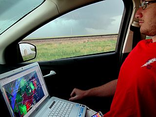
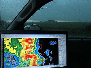
Derek Sibley checking out the radar and navigation options on the laptop while the HP supercell storm looms out the window to our west as we stopped north of Stratford, Texas late on May 16. |
|
Looking northwest of Amarillo, Texas, a supercell storm looms high into the sky late on May 16. Note the airplane and contrail to the left going south of the storm at high altitude. This storm was producing baseball sized hail at the time. |
|
While heading southeast towards Decatur, Texas (from Wichita Falls) along Highway 287, and elevated strong to severe storm looms to our north early on May 17. These types of storms are caused by the low level jet going up and over a warm front / boundary and (isentropic) lifting both a stable layer and elevated mixed layer above that, causing storms with high bases. |
|
Derek Sibley and Mark Farmer prepare to depart back to Florida in their vehicle (a Dodge Charger) they left in Decatur, Texas. Although not suitable for chasing, Mark's car here boasts a 6 speed manual and over 400 HP. After I dropped them off, I continued back to Dallas to fly back to Chicago later that day. These folks were great people to chase with. |
| CHASER NAME | HOME CITY | CALLSIGN | CHASE DATES | OCCUPATION |
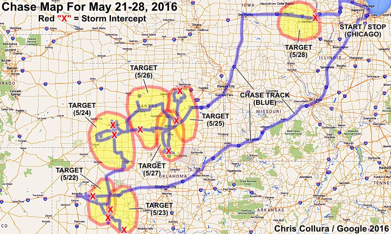
| CHRIS COLLURA | CHICAGO, IL | KG4PJN | 5-21 TO 5-28 | IT CONSULTANT |
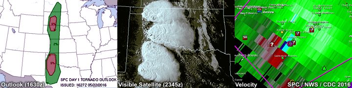
1). May 22, 4:30 PM - Interception and penetration of a very severe thunderstorm near Groom, Texas along Interstate 40 in Carson County. This storm was the left split of a developing supercell storm of which its southern component eventually became tornadic. Mainly large hail was observed from an I-40 underpass, with pieces ranging from quarter to golfball sized. Frequent lightning, heavy rains, and 45 MPH winds were also observed with this storm. Conditions causing these storms were surface heating, a low pressure trough, upper trough, and dryline. A 2009 Ford Escape SUV was used to chase the storms. Documentation was digital stills and HD video. A tornado watch was also valid for the area until 10 PM CDT.
2). May 22, 7:00 PM - Interception and penetration of an extremely severe and tornadic thunderstorm southwest of highway 287 in Hall County, Texas to the southwest of Memphis and near Lakeview. The storm was a cyclic HP supercell storm, forming on the south end of a cluster of severe thunderstorms. This storm developed intense rotation, and at least three large tornadoes were observed with this storm (cone with a small satellite and multi-vortex that nearly became wedge dimensions before becoming rain wrapped). These tornadoes fortunately occurred over open country. The storm also contained extremely heavy rains, causing flash flooding. Frequent lightning with close hits, winds gusting over 60 MPH (especially inflow), and hail up to tennis ball sized was observed with this storm. Conditions causing these storms were surface heating, a low pressure trough, upper trough, and dryline. A 2009 Ford Escape SUV was used to chase the storms. Documentation was digital stills, HD video, and audio. A tornado watch was also valid for the area until 10 PM CDT.
3). May 23, 4:30 PM - Interception and penetration of a very severe thunderstorm to the north of Hedley, Texas in Donely County to the northwest of Highways 287 and 203. This storm was an LP supercell storm. Large hail to golfball sized, 30 MPH winds, frequent lightning, and light rain was observed with this storm. The storm undergone downscale development and dissipated after a few hours. Conditions causing the storms were surface heating, a low pressure trough, dryline, and upper trough. A 2009 Ford Escape SUV was used to chase the storms. Documentation was digital stills and HD video. A tornado watch was in effect for the area until 10 PM CDT.
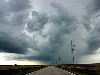
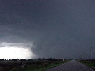
4). May 23, 9:00 PM - Interception and penetration of an extremely severe and tornadic thunderstorm to the southeast of Turkey, Texas in Hall County and east of Highway 70 along county road 656. The storm was an HP / classic supercell storm. This supercell had a striking visual appearance, and multiple funnels were produced. The storm back-built to the northwest after dark, and intensified significantly. A large tornado was observed south of my location on 656 at about 9:30 CDT. This was a multivortex / cone tornado, mainly lightning illuminated. This tornado moved southeast, then turned north, and moved northwest! Winds gusting from 80 to 100 MPH with torrential sideways rain and hail to tennis ball sized were encountered at this time. The tornado evolved to a wedge tornado, then crossed the road to my east, then a large cone tornado to my north before lifting. Frequent lightning with close hits was also observed with this storm. The storm also caused flash flooding, but the tornado remained over open country. Conditions causing the storms were surface heating, a low pressure trough, dryline, and upper trough. A 2009 Ford Escape SUV was used to chase the storms. Documentation was digital stills and HD video. A tornado watch was in effect for the area until 10 PM CDT.
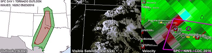
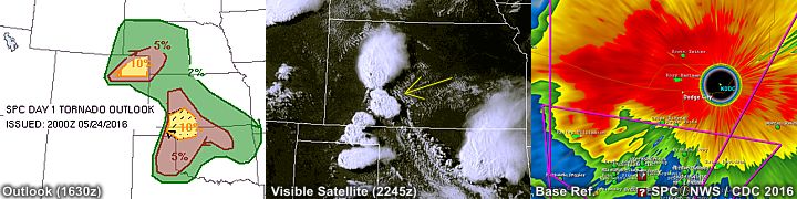
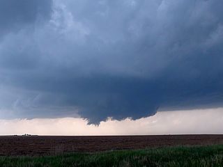
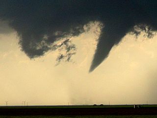
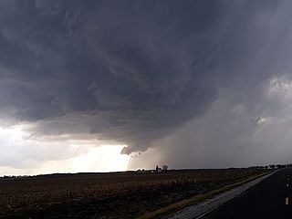
5). May 24, 6:30 PM - Interception and observation of an extremely severe and tornadic thunderstorm from north of Mineola, Kansas to and past Dodge City in Clark and Ford Counties from along Highway 283. This thunderstorm was a violent cyclic classic supercell producing multiple tornado "families". The storm developed to the northwest of Mineola and moved to the northeast, barely missing the western portions of Dodge City. The core of the storm, containing extremely large hail (one report had 5 inch hail, larger than a compact disc) and strong winds, was not penetrated. The storm produced at least 8 tornadoes with multiple cycles, and was observed from initiation to dissipation south of Jetmore, Kansas. The tornadoes were pretty much all varieties: stove pipe, elephant trunk, multiple vortices, cones, even a truncated wedge! Even more spectacularly, there were times when there were two (twins), or even three, tornadoes on the ground simultaneously (usually one from the original mesocyclone still on going, with a new tornado on the next new cycle)! The tornadoes remained mostly over open fields, and thankfully passed west of Dodge City, damaging mostly outbuildings. The supercell storm had an impressive and striking visual appearance (like an "upside down wedding cake" and striations). One of the last tornadoes observed was even anticyclonic (revealed with time-lapse footage)! Frequent lightning with some close hits was also encountered, with isolated 1" hail stones falling in 50 to 60 MPH inflow. Conditions causing the storms were surface heating, a low pressure trough, dryline / boundary interactions, and upper trough. A 2009 Ford Escape SUV was used to chase the storms. Documentation was digital stills and HD video. A tornado watch was in effect for the area until 12 AM CDT the next day.
6). May 24, 10:00 PM - Penetration of a severe thunderstorm near Pratt, Kansas in Pratt County along Highway 54 / 400. This storm was a multicell severe / HP supercell storm. Very heavy rains, frequent lightning with close hits, hail up to half-dollar (1.5"), and winds gusting over 60 MPH. Conditions causing the storms were a low pressure trough, boundary interactions, and upper trough. A 2009 Ford Escape SUV was used to chase the storms. Documentation was audio. A tornado watch was in effect for the area until 12 AM CDT the next day.
7). May 25, 6:00 PM - Interception and observation of a severe thunderstorm near El Dorado, Kansas in Butler County near Highways 254 and 77. This storm was an LP supercell storm, with an impressive "barber pole" updraft, and striking visual appearance despite its small size. The storm core was small and probably had 1" hail, but was not penetrated. The storm undergone downscale evolution and basically evaporated after a couple of hours. Conditions causing the storms were surface heating, a dryline, low pressure trough, and upper trough. A 2009 Ford Escape SUV was used to chase the storms. Documentation was HD video, time-lapse, and digital stills. A tornado watch was in effect for the area until 9PM CDT.
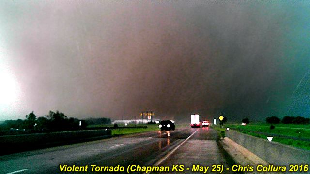
8). May 25, 8:30 PM - Long-range interception, observation, and indirect penetration of an extremely severe and violent cyclic long-track thunderstorm from near Abilene, Kansas and I-70 in Dickinson County. This storm was first observed from a 100 mile distance, with an overshooting top (probably to 60,000 feet) and a long-range intercept was done given the fact that is was in a great environment for tornadoes, despite SPC outlooks. When the storm was finally intercepted east of Abilene, a large and violent wedge tornado, up a mile and a half wide, was observed at close range west of Chapman and crossing I-70. This was an extremely powerful tornado, which was supposedly on the ground for a staggering 90+ minutes! Damage observed was trees debarked and ground scouring. The tornado did extensive damage to anything it hit. In addition, 70 MPH winds, tennis ball sized hail, frequent lightning, and horizontal rain was encountered with this storm. Conditions causing the storms were surface heating, a dryline, low pressure area, and upper trough. A 2009 Ford Escape SUV was used to chase the storms. Documentation was HD video, time-lapse, audio, and digital stills. A tornado watch was in effect for the area until 9PM CDT.
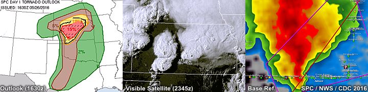
9). May 26, 7:00 PM - Observation of a severe thunderstorm from Bucklin to near Protection along Highways 34 and 183 in Ford and Comanche Counties. The storm was an HP supercell storm, developing on the southern end of a line segment. The main core of the storm was not penetrated, but contained 2" hail and strong winds. The storm became undercut by outflow and later weakened near Greensburg in Kiowa County. The storm had a striking visual appearance with a "stacked plates" effect during its most intense phase. Conditions causing the storms were surface heating, a low pressure area, dryline, and upper trough. Documentation was digital stills and HD video. A 2009 Ford Escape SUV was used to chase the storms. A tornado watch was also in effect for the area until 10PM CDT.
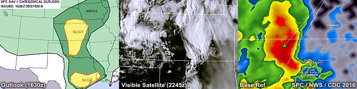
10). May 27, 4:30 PM - Observation and indirect penetration of a very severe thunderstorm from southwest of Braman in Kay County Oklahoma and northward into Sedgwick County, Kansas near Highway 81 and I-35. The storm was an HP supercell storm. Frequent lightning, very heavy rains, 50 MPH winds, and hail to 1.25" were encountered with this storm. The main core had hail to baseball sized, and was avoided as I had my front hail guards removed at the time. Some funnels were also observed, one with a large wall cloud, before these storms became outflow dominant. Conditions causing the storms were surface heating, a dryline / Pacific cold front, low pressure area, and upper trough. Documentation was digital stills, audio, and HD video. A 2009 Ford Escape SUV was used to chase the storms. A severe thunderstorm watch was also in effect for the area until 10PM CDT.
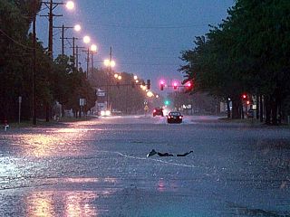
11). May 28, 5:30 PM - Observation of strong to severe thunderstorms in eastern Iowa and western Illinois near I-80 and from Davenport in Scott County and eastward across the Mississippi River into Rock Island County. The storm was a multicell cluster of severe thunderstorms, with some transient supercells. The cores were not directly penetrated, but heavy rains, small hail, frequent lightning, and winds gusting near 60 MPH were encountered east of Davenport on I-80. These storms were encountered during the end of this chase trip and en-route to the Chicago area. These storms were caused by an advancing Pacific cold front, surface heating, and upper trough. Documentation was digital stills. A 2009 Ford Escape SUV was used to chase the storms. A severe thunderstorm watch was also in effect for the area until 9PM CDT.
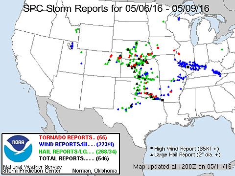
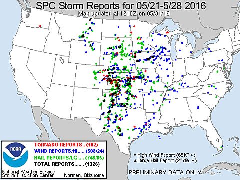
This concludes the Chase Log for the central US Plains and Midwest (tornado alley) main 2016 chase trip from May 21 through May 28. The summary includes a total of 11 severe thunderstorms and at LEAST 15 tornadoes. One severe thunderstorm alone in Dodge City, Kansas on May 24 notably was the most prolific tornado producer, with at least 8 tornadoes, with multiple tornadoes on the ground simultaneously. Many of the other severe storms observed produced significant tornadoes, notably the northern Kansas storm on May 25 which had a violent (EF4+) tornado on the ground for at least 90 minutes! The main chase vehicle conducting all chases was a 2009 Ford Escape SUV. This information was prepared exclusively for the National Weather service and the team of Skywarn storm spotters.
|
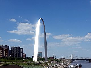
Heading out via a long road trip and through Saint Louis, Missouri en-route to Oklahoma City (from Chicago). Beautiful view of the gateway arch. |
|
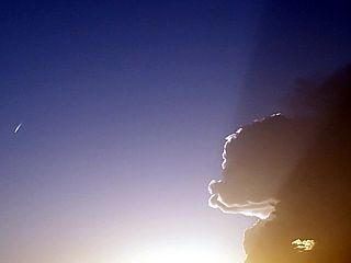
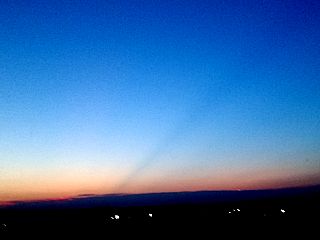
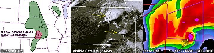
While passing through Tulsa, Oklahoma, a ray of light is cast across the sky. Actually this is most likely the shadow cast from the 60,000 foot overshooting top of a tornadic supercell storm, at least 250 miles away near Leoti, Kansas at the time! |
|
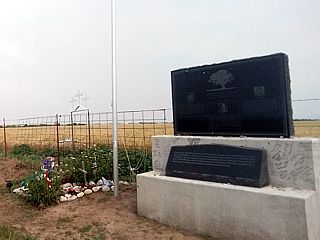
Here is a picture of the memorial for Tim and Paul Samaras, and Carl Young, killed in 2013 in the May 31 El Reno, Oklahoma tornado. The old memorial is to the left, and a more permanent one is to the right with a flagpole added and pictures of the three chaser-scientists engraved in the granite surface. This was taken just to the east of the intersection of Radio and Reuter Roads on May 22, 2016 while en-route to my first target area of the day. |
|
Supercell storms initiating in Carson County, Texas near Groom. The view is looking up at the top of the developing storm through the windshield and hail guards while heading east on I-40 on May 22. |
|
A piece of large hail that fell near Groom, Texas on May 22. |
|
HP / Classic supercell storm to the west of Memphis, Texas in Hall County. A funnel and RFD can be seen developing in the rotating base of this storm. This was during the evening of May 22, 2016. |
|
Funnel developing on the supercell storm west of Memphis, Texas. |
|
Possible brief tornado, the first of this storm, west of Memphis, Texas late in the day on May 22. |
|
Later on the cyclic supercell storm passed to the southwest of Memphis, and near Lakeview, Texas. In this picture, the so called "Bear's Cage" cane be seen looking west in 60 MPH inflow winds, with a large forward-flank funnel to the left, and tornado touching down near the inflow and RFD point to the right. |
|
Tornado widens into a large cone / truncated wedge tornado near Lakeview, Texas. |
|
Same tornado evolves to a multi-vortex tornado. |
|
Another large tornado southwest of Memphis, Texas and southeast of Lakeview in Hall County. The view is looking SW on May 22. |
|
Another view of the tornado becoming partly rain wrapped and with a satellite to its right just before bailing on the storm (this was coming right at me) and heading NE towards Memphis, Texas near dusk on May 22. |
|
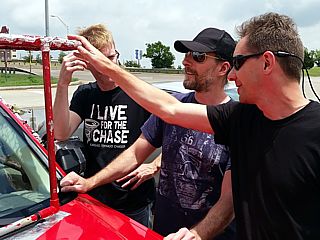
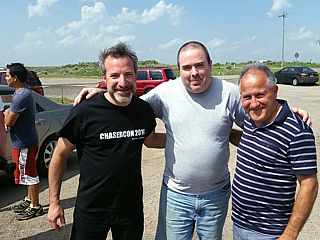
Chaser "convergence" in Shamrock, Texas near I-40 before a great chase day on May 23. From left to right: Mark Robinson, Jason Persoff, and George Kouranis. These folks were checking out my hail grills on my vehicle. |
|
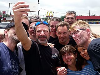
Group "selfie" of the group of chasers in Shamrock, Texas on May 23 before chasing. Jason Persoff is taking the picture. |
|
LP (low precipitation) supercell storm near Hedley, Texas in Donely County during the early afternoon of May 23. |
|
Doppler on wheels (DOW) vehicles associated with the TWIRL project along highway 203 near Hedley, Texas. Tim Marshall and Josh Wurman is in this group of researchers as well. |
|
A view of the anvil and main updraft of the LP supercell near Hedley before undergoing downscale development on May 23. This storm was producing golfball sized hail. |
|
Tail end "Charley" classic supercell storm to the north of Turkey, Texas in Hall County late in the afternoon on May 23, 2016. This storm would eventually produce tornadoes after dark east of town! |
|
View of inflow tail and updraft region of the Turkey, Texas supercell storm on May 23. |
|
Rotating wall cloud and funnel develops on the classic supercell storm north of Turkey, Texas. |
|
Interesting "rotor" like feature north of the Turkey, Texas supercell after it split. The view is looking SSW. Quite possible the horizontal "tube" of air along a boundary (that the storm is anchored on) being pulled in and before being lifted / tilted vertically. |
|
Small needle funnel on the supercell storm now southeast of Turkey, Texas. This entire base was rotating after the storm split earlier. The view is north around dusk on May 23. |
|
Large wall cloud / funnel southeast of Turkey, Texas (view is NW) as the storm re-organizes and becomes an HP storm for a bit after dusk on May 23. |
|
Large hail laying in the ground from the storm SE of Turkey, Texas after dark on May 23. Some pieces were tennis ball sized. One can be seen impacting the road just left of the center of the picture. |
|
Lightning illuminated image of the updraft base of the rapidly intensifying supercell southeast of Turkey, Texas after dark on May 23. The view here is to the east from just north of a developing tornado. |
|
Lightning illuminated clouds (note the mesocyclone and barely visible cone tornado developing underneath it near the center of the picture)! The view is south on May 23 from County-Road 656. |
|
Lightning illuminated cone tornado (with lightning strike to its left) well after dark to the southeast of Turkey, Texas on May 23. |
|
Partial rain wrap and cone tornado as lightning strikes to the right of the tornado. |
|
Closer view of lightning strike and cone tornado to my south. |
|
Closer still of the lightning and cone tornado southeast of Turkey, Texas. Very strong inflow / RFD (winds 80 to 100 MPH) is buffeting me and the image is blurred. Time to back off! |
|
Blurry (lightning illuminated) of the same cone tornado that has transitioned to a multi-vortex / wedge tornado (this tornado was rated EF-3 later). The tornado is now moving NORTHWEST and I am in its path. I am making a hasty retreat west in powerful winds. |
|
Tornado continuing to move NW, crossing the road where I was a few minutes earlier in its multivortex stage. This view is looking east on County-Road 656. Tornado is lightning illuminated, and is centered pretty much over the road and to the right of the center of the picture. |
|
View of large cone / wedge tornado to my north after backing off earlier and returning east on County-Road 656. The view is due north and I am in near calm winds now. A loud roaring sound could be heard as I took this picture. This tornado lifted a few minutes later. |
|
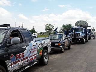
Again we meet! Huge chaser convergence before a major chase day at the intersection of 283 and 270 south of Laverne, OK on May 24, 2016. From left to right here is: Jason Persoff, Dan Robinson, and Danilo Grkovich. Many chasers were on this remote roadside lot. Scott Peak is standing in the background to the left as well. A hot dog stand would have been nice! |
|
First rotating wall cloud / funnel forming on the soon to be cyclic supercell between Mineola and Dodge City, Kansas on May 24. The view is to the west. |
|
First tornado touches down during the afternoon / evening south of Dodge City, Kansas on May 24. This storm will be referred to as the "Dodge City Supercell", a classic and violent cyclic storm that will produce at least 8 tornadoes, some of which with multiple instances on the ground simultaneously! |
|
First tornado intensifies. Note the two chaser vehicles in close range! |
|
First tornado occludes, then begins to rope out slowly. This view is zoomed in to show the intense ground circulation and two chase vehicles in close proximity. |
|
Sinuous rope out of the first tornado south of Dodge City. |
|
View of the main and most intense cyclic tornado of this storm. A large stove pipe quickly develops over the open country south of Dodge City (May 23). |
|
Another view of the intensifying stove pipe tornado. |
|
Here is a "selfie" (self portrait) of myself, my chase vehicle, and the mayhem unfolding a couple of miles behind me southwest of Dodge City, Kansas on May 24! |
|
Stove pipe tornado at its maximum intensity and width. Wow! |
|
With the near steady-state stove pipe tornado in progress, the new mesocyclone forms sympathetically east of the main one. This new area goes on to produce a multivortex tornado, along with a few smaller tornadoes, all while the stove pipe to its left is on-going! |
|
Close up of the multivortex / multiple tornadoes to the right of the main stove pipe tornado on-going. |
|
At least two tornadoes on the ground. Main stove pipe to the left, smaller tornado on-going to the right! |
|
Close-up of one of the tornadoes to the right of the main stove pipe on the new mesocyclone. |
|
Wider view of both mesocyclones, with a new tornado about to form on the right (new) one, and the stove pipe still ongoing to its left. |
|
Both the old (left, with massive stove pipe tornado) and new (right, with tornado on the ground as well) mesocyclones. Twin tornadoes (wow)! |
|
Main stovepipe and new mesocyclone to the right, with simultaneous tornadoes a minute or so later. This was repeated a few times. Eventually, the new (right) mesocyclone became dominant, and absorbed the weakening / roping out stove pipe from the old mesocyclone. This weakening tornado wrapped around the new mesocyclone like a satellite tornado before being absorbed. |
|
Wider view of the process where the new mesocyclone was intensifying and just before the stove pipe (now a thinning rope) to its left became entrained into it. Massive upward motion also noted on the right (forward flank) of the new mesocyclone / wall cloud. |
|
As the storm nears the western sides of Dodge City, Kansas on May 24, it intensifies again (new mesocyclone now dominant and the stove pipe is gone). It is VERY fortunate this tornado "family" missed Dodge City proper. In this picture, at least eight subvortices can be seen rotating around a large "main" developing tornado. |
|
Large truncated cone / wedge tornado grazing the west sides of Dodge City, Kansas with my vehicle in the foreground. I am on the south side of town looking NW. |
|
View a few minutes later showing a large truncated cone / wedge with a stove pipe (internal subvortex) in the middle of it! Note that another mesocyclone is about to form east (right) of this tornado, and will be part of the next storm "cycle". |
|
Close up of truncated cone / wedge tornado with internal subvortex. The motion on this was incredible. |
|
The highly cyclic supercell storm continues to the north of Dodge City, damaging only a few outbuildings. In this picture, yet another new mesocyclone (and large wall cloud) is forming east of the cone tornado in progress. This is now late afternoon on May 24. |
|
Old (former) mesocyclone and newest one forming to its east with impressive supercell structure. The former mesocyclone has a tornado (formerly the cone tornado) that is roping out. |
|
Close up of tornado roping out prior to additional tornado-genesis to its east. |
|
Twins again! Rope tornado from former mesocyclone still on the ground, and a large elephant trunk / stovepipe tornado on the newest mesocyclone to the right. The view is NW and the storm is north of Dodge City and south of Jetmore. |
|
Elephant trunk has now formed a large cone tornado, rope almost gone at the time. Power flashes occur as powerlines are taken down by this new tornado. |
|
The cyclic supercell storm finally weakens south of Jetmore, Kansas as cells began firing south of it. During the last cycle, this anti-cyclonic (rotating clockwise, and rare in the northern hemisphere) forms just after the elephant trunk / cone weakened. After this, the storm did not produce any more tornadoes, and upscaled to a line segment of severe storms. |
|
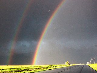
While heading east on Highway 54 / 400 towards Greensburg, Kansas - I am treated to one of the most intense rainbows and sunsets I ever seen. |
|
Low precipitation (LP) supercell rotating hard near El Dorado, Kansas on May 25, 2016. This storm weakened via downscale evolution and essentially evaporated in a stronger cap. Attention turned to a distant tornadic supercell in the northern fringes of the target area for the day. |
|
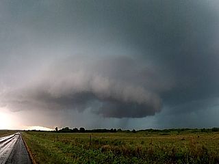
Here is a picture of an overshooting top, probably 60,000 feet high, from 75 miles distance of a tornadic supercell storm currently near Salina, Kansas. This was the storm that will have a tornado on the ground for nearly two hours! I am heading north (after being "suckered" south to a dying LP storm) for a long-range intercept. |
|
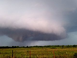
Getting closer, maybe 25 miles away, the back-sheared anvil from the Salina / Abilene, Kansas supercell - Still with a large wedge tornado in progress - Looms over the afternoon sunlight looking NW on May 25. |
|
Finally I can see the base - And there it is! A large wedge tornado from a distance of about 10 miles, while the cyclic supercell was passing near Abilene, Kansas. |
|
RFD clear slot and violent tornado from 5 miles away, and to the ESE of Abilene, Kansas approaching I-70. |
|
Violent tornado, looking ENE, approaching I-70 between Abilene and Chapman near sunset on May 25, 2016! A loud roaring sound could be clearly heard at this time. |
|
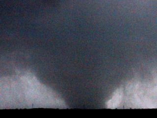
Violent wedge tornado near Interstate 70 and not far from Chapman, Kansas. This is about a half of a mile away, close enough to FEEL the roar of it! |
|
Wedge tornado at its most intense crossing the ENE jog of I-70 and headed just south of Chapman, Kansas after being on the ground for 90 minutes. The white streaks falling are hail stones to tennis ball sized. The object in the highway to the lower left is a large turtle crossing the road! |
|
Violent wedge tornado almost over I-70 and headed due east towards Chapman, Kansas. |
|
Tornado now over the Interstate. Traffic stopped and police creating a rolling roadblock so no one drives into it. Incredible motion. Wedge tornado now about to graze the south side of Chapman, Kansas. This tornado was rated at LEAST EF-4, with winds strong enough to bend railroad tracks! |
|
A pile of debarked mangled trees swept up the embankment on the south side of I-70 near Chapman, Kansas. Also note the grass is almost gone and the ground has been scoured to bare dirt. |
|
HP supercell storm on the south end of a line segment near Ford and Comanche Counties in Kansas during the evening of May 26, 2016. This was pretty much the only good storm of the day. |
|
Panoramic view of the HP supercell storm over Ford and Comanche Counties from near Protection, Kansas on May 26. |
|
Rotating section of a supercell storm near Greensburg, Kansas as it was being undercut by outflow late on May 26. |

|
Bark Comstock with his tour group (Extreme Tornado Tours) in Greensburg, Kansas. The "over-extended" damaged door was from strong winds during the May 25 violent tornado in northern Kansas a couple days earlier. |
|
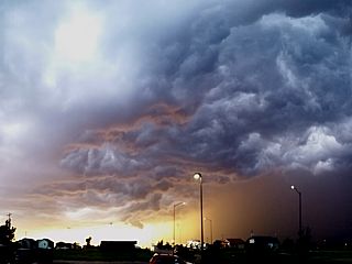
Interesting gust front, sunset, and "whales mouth" over Greensburg, Kansas from an outflow dominant storm late on May 26. |
|
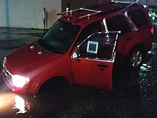
My vehicle stuck in a flooded ditch, and conveniently in my hotel in Wichita for the night on May 26-27. The poorly designed parking lot was flooded by heavy rains, and the entrance was not visible. Luckily a call to AAA had the vehicle winched out quickly with no damage. |
|
Supercell storm developing south of the Oklahoma / Kansas border and west of I-35. The view is from Sedgwick County in Kansas, looking south, on May 27, 2016. |
|
Supercell intensifies and becomes HP (high precipitation) with a hail core containing hail up to baseball sized on May 27. The view is to the south from Sedgwick / Kay counties. |
|
Funnel on forward flank of mesocyclone from a storm near I-35 and south of Braman, Oklahoma. |
|
Hail core of HP supercell storm near Braman in Kay County Oklahoma. |
|
Funnel and wall cloud on HP supercell storm southwest of Braman (Kay County) Oklahoma. |
|
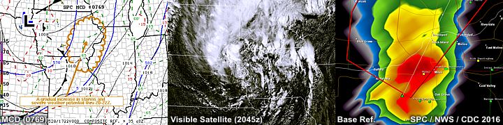
Computer laptop display showing the base reflectivity radar of an intense line segment with the view out the window as I drive on I-35 towards Emporia, Kansas. |
|
View of a supercell storm forming on the southern part of a line segment from near Davenport, Iowa on May 28. |

|
Small funnel on the updraft of a severe storm near Rock Island County, Illinois. |
|
Blowing dust and inflow ahead of a line of severe thunderstorms in Rock Island County, Illinois. |
|
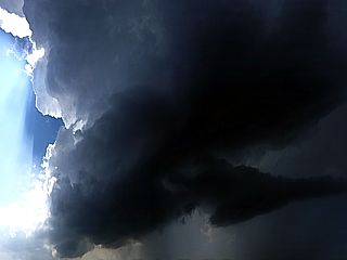
Backside of supercell storm / line segment near Rock Island County, Illinois. Note the RFD clear slot and wall cloud. |
|
This is a large dent in the main hail grill that protected the front windshield. Probably a tennis ball to baseball sized hailstone (most likely from May 23). Had the grill not been there, the windshield most likely would have been shattered. |
|
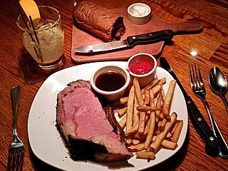
Again - Celebratory steak dinner at the Outback Steakhouse back in Chicago to wrap up the final travel day of the trip. |
| CHASER NAME | HOME / BASE CITY | CALLSIGN | CHASE DATES | OCCUPATION |
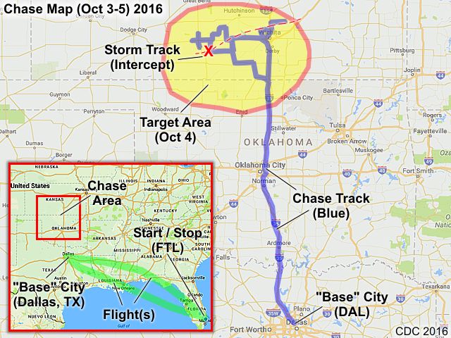
| CHRIS COLLURA | DEERFIELD BEACH, FL | KG4PJN | 10-3 TO 10-5 | IT CONSULTANT |
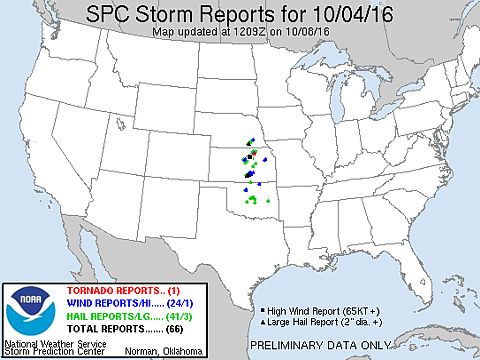
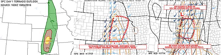
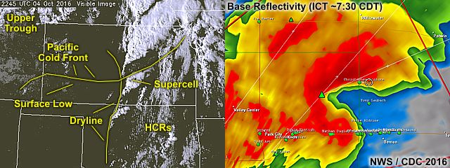
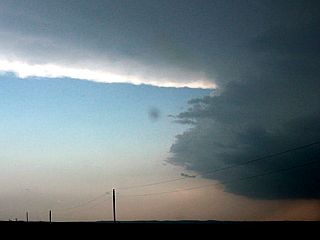
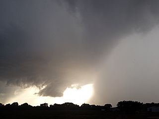
1). Oct 4, 7:00 PM - Observation and penetration of a very severe thunderstorm from near Kingman, Kansas and points east and northeast to the northwest of Wichita, Kansas in Sedgwick County, from along Highway 54 / 400 and east of I-135 and Park City. The storm was a supercell storm which started out as a classic supercell. The storm evolved to an HP storm near Wichita, with a very striking (stacked plates) visual appearance, rotating wall cloud and funnels, and intense (green shaded) hail core / vault on its northern FFD side. The storm was not directly penetrated during its intense phase, where hail reports of over 2" occurred in Sedgwick County. Winds gusting over 65 MPH, hail to 1", frequent lightning, and torrential rains were encountered with this storm. A brief tornado also may have been observed near Maize, Kansas, bit has not been officially confirmed. Some flooding, power outages, and tree / sign damage was also observed with this storm. These storms were caused by a dryline, Pacific cold front, a low pressure area, upper trough, and surface heating. Documentation was digital stills and HD video. A 2016 Ford Fiesta rental was used to observe the storms. A tornado watch was also in effect for portions of the area until 9 PM CDT.
This concludes the chase log for the central US Plains (including the chase in Kansas) chase trip for October 3-5, 2016. The summary includes a total of 1 severe thunderstorm. A possible weak tornado may also have been observed. The main chase vehicle conducting this chase was a 2016 Ford Fiesta Rental. This information was prepared exclusively for the National Weather service and the team of Skywarn storm spotters.
|
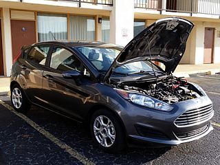
Here is a picture of the chase vehicle being prepared to this short chase trip on October 3. This was a Ford Fiesta that got over 40 miles to the gallon (and costed less than $20 to fill it up at some of the cheaper gas stations)! Here the hood is open to run the 12 VDC power from the battery into the inverter in the car. |
|
View (looking west) of the developing dryline near Kingman, Kansas from under a rain free base that will soon become a supercell storm on October 4th. |

|
Explosive development of severe storms, viewed from just behind the dryline / Pacific front intersection west of Kingman, Kansas. |
|
Wall cloud forming south of updraft-downdraft interface near Cheney, Kansas as the supercell storm moves east of the dryline and into Sedgwick County. |
|
Wall cloud and intense inflow features as the supercell storm evolves from classic to HP mode west of Wichita. |
|
Possible weak toornado to the northwest of Wichita near Maize, Kansas while in powerful inflow. |
|
Impressive structure of HP supercell storm at dusk while looking west on I-135 and north / northeast of Wichita, Kansas near Park City. |
|
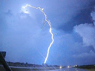
Beautiful cloud to ground (CG) lightning strike on backside of storms over I-135 north of Wichita, Kansas late in the evening on October 4. |
|
Flying out of Dallas, Texas (during the evening of October 5) and later into a hurricane warning in Florida on the last flight back! Note the supercell storm looming over the horizon to the upper right! |
1). Mar 15, 5:30 PM - Interception and observation of a very severe thunderstorm near West Point, Illinois near Highways 110 and 94 in Hancock County. The storm was a classic supercell storm with a rotating wall cloud, and was followed northeastward towards Plymouth before it weakened. The storm core was not directly penetrated, but contained winds near 60 MPH (mainly RFD), heavy rains, occasional lightning, and some small funnel clouds. The storm core had hail to golfball sized, and this was noted covering the ground near Tennessee, IL later in a small swath. The storm was caused by a warm front, strong upper trough, surface heating, and a low pressure area. Documentation was digital stills and HD video. A 2009 Ford Escape was used to chase the storm. A tornado watch was valid for the area until 9 PM CDT.
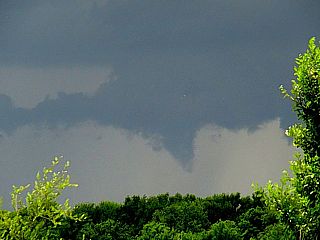
2). Mar 15, 6:15 PM - Interception, observation, and penetration of a very severe and tornadic thunderstorm from near Carthage, Illinois in Hancock County and points east and northeast along Highways 136 and 9 through Good Hope and Bushnell in McDonough and Fulton counties, and eventually through Peoria along Highway 24 in Peoria County. This storm was a powerful HP / classic supercell storm, which produce 3 tornadoes. The first of these tornadoes was observed passing just north of Carthage as a diffuse, rain-wrapped tornadic circulation. The second storm "cycle" occurred in McDonough County near Blandinsville and towards Good Hope, where an extremely powerful RFD surge to 80 MPH was encountered south of another multi-vortex tornado. A low bowl shaped lowering with intermittent ground circulations was observed before rain wrap ensued again. A final possible tornado, in heavy rain and west of Trivoli, IL, was observed as a large and broad funnel at dark. Extremely heavy rains, frequent lightning, and hail to 2" were observed as well. Winds outside the RFD surges also gusted near 70 MPH. This storm also caused flooding and some damage. The storm passed near Peoria before upscale growth into a powerful MCS / bow segment. The storm was caused by a warm front / cold front occlusion point, strong upper trough, surface heating, and a low pressure area. Documentation was digital stills, audio, and HD video. A 2009 Ford Escape was used to chase the storm. A tornado watch was valid for the area until 9 PM CDT.
3). Mar 15, 8:30 PM - Penetration of a small severe thunderstorm near I-39 and I-80 in LaSalle County, Illinois. This storm was an elevated severe storm on the backside of a cluster of severe storms associated with an occluded cold front. The storm had winds near 60 MPH and hail up to 1". Frequent lightning, with close hits (one about 100 yards from the roadside), and torrential rains were also encountered. This slightly elevated severe storm was caused by an occluded cold front, strong upper trough, and a low pressure area. Documentation was audio. A 2009 Ford Escape was used to chase the storm. A tornado watch was valid for the area until 9 PM CDT.
4). Mar 31, 1:00 PM - Observation of a strong thunderstorm at an office location in Hoffman Estates in Cook County, IL just north of Interstate 90 and west of Highway 59. This was an unwary observation from a fixed location (office building). The storm was part of a line / cluster of strong thunderstorms, and had an area of weak rotation at one point. Frequent lightning, very heavy rains, 40 MPH winds, and hail to 1/2" was observed with the passage of this storm. The vehicle parked at the location was a 2009 Ford Escape. Documentation was audio and digital stills. The storm was caused by a low-pressure area, cold front, and upper trough.
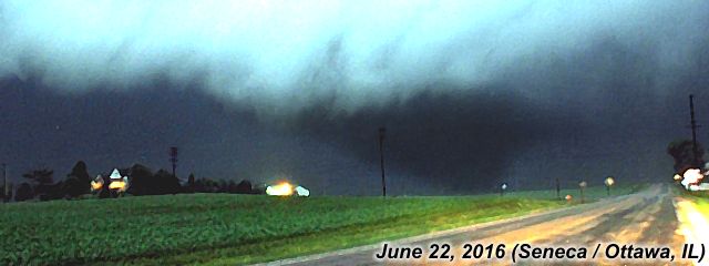
5). June 22, 7:30 PM - Observation and penetration of a very severe and tornadic thunderstorm in Lee County, Illinois near Highway 52 around Amboy and towards Mendota. The storm was an intense HP supercell storm, which contained rain wrapped tornadoes. One of these possible multiple vortex tornadoes were observed in poor visibility from the north in powerful easterly winds (gusting over 70 MPH). The storm contained winds gusting over 70 MPH, small hail, frequent lightning with some close hits, and torrential rains. The storm had a large, wet RFD. Damage was observed near Mendota, particularly to power poles, signs, and trees. Some roof debris and sheet metal was noted across the roadway in some cases. Power was also knocked out and there was flooding. The storm also had a striking visual appearance (stacked plates and striations) looking north or west. This storm was eventually abandoned for another supercell storm to the southwest. Conditions causing the storms were surface heating, a low pressure area, warm front, and upper trough. Documentation was HD video and digital stills. A 2009 Ford Escape was used to chase the storm. A tornado watch was valid for the area until 1 AM CDT the following day.
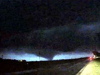
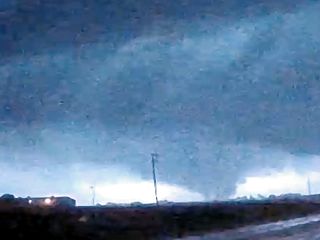
6). June 22, 9:00 PM - Observation and penetration of an extremely severe and tornadic thunderstorm in LaSalle County Illinois from Highway 23 between Ottawa and Troy Grove, and southeastward to near Seneca and Morris on Highway 6 south of I-80. This storm was also a large HP supercell storm. The storm produced several confirmed tornadoes, one weak one observed west of Ottawa, and another significant one near Seneca along Highway 6 at around 9:05 CDT. This was a very large cone tornado, almost a wedge, illuminated by lightning. The storm produced very intense and frequent lightning with many close hits, small hail, torrential rains, and winds gusting near 80 MPH (mainly FFD). The large tornado near Seneca destroyed a house, powerlines (power flashes observed), and flattened crops before evolving to a stove-pipe, then roping out and becoming wrapped in rain. The storm was abandoned as it passed south of Morris, however, a possible tornado was observed again from 30 miles distance as the storm was passing well to the south near Odell and Pontiac while attempting to photograph lightning. This storm also had a very striking visual appearance, much of which was revealed by the continuous lightning. Conditions causing the storms were surface heating, a low pressure area, warm front, and upper trough. Documentation was HD video and digital stills. A 2009 Ford Escape was used to chase the storm. A tornado watch was valid for the area until 1 AM CDT the following day.
7). July 23, 5:30 PM - Interception and observation of strong to severe thunderstorms from near Woodstock in McHenry County, Illinois near I-90 and later to a fixed location near Lawrence and California Avenue in the north side of Chicago in Cook County. The storm was a multicell cluster of strong and severe storms, initially with some embedded supercells. The storms had slight rotation but became outflow dominant quickly. Heavy rains, 50 MPH winds, and frequent lightning with some close hits were observed. Some tree damage and flooding was noted in the Chicago area, with power out in a few places. The storms were caused by surface heating, a stalled frontal boundary, and an upper trough. A 2009 Ford Escape was used to chase the storms. Documentation was digital stills. A severe thunderstorm watch was also valid for the area until 10 PM CDT.
8). July 24, 6:00 PM - Observation of strong to severe thunderstorms from near Foster Avenue and North Broadway while stuck in traffic west of Lakeshore Drive on Chicago’s north side in Cook County, Illinois. The northern side of the storm was penetrated and contained winds gusting near 60 MPH, small hail, very heavy rains, and frequent lightning with some close hits. The storm was a multicell cluster of severe thunderstorms. Some flooding and tree damage was observed, with power out in a few places. The same storm caused a platform collapse on a local train station farther to the west. Conditions causing the storms were surface heating, a stalled frontal boundary, and an upper trough. A 2009 Ford Escape was used to observe the storms. Documentation was audio.
This concludes the chase log for the central United States and Midwest (including tornado alley / Illinois as of July 26, 2016) for ANY OTHER chases in 2016 not part of a special section (especially those for single-day "spot" chase trips). The summary includes a total of 8 observations. Out of the observations, there were 7 severe thunderstorms and 1 strong thunderstorm. Out of the thunderstorms, 5 possible tornadoe were observed. The main chase vehicle conducting these chases was a 2009 Ford Escape. This information was prepared exclusively for the National Weather service and the team of Skywarn storm spotters.
|
When the sky looks like this - Something is going on with the atmosphere! Mid level ACCAS with convective rolls over IL as upper level trough moves overhead from the west on March 15, 2016. |
|
Supercell storm southwest of Carthage, IL on March 15, 2016. |
|
Explosive development of supercell storm looking at back-sheared anvil and updraft tower as the storm moves out of far NW Missouri and into West-Central Illinois (west of Carthage). March 15. 2016. |
|
Possible weak and diffuse tornado west of Carthage, IL on March 15, 2016. |
|
Close-up and rain wrap of wall cloud and weak / diffuse tornado west of Carthage, IL on March 15, 2016. |
|
Intensification as supercell cycles east of Carthage and into McDonough County with an intense RFD clear slot! March 15, 2016. |
|
Possible tornado behind the intense RFD clear slot in McDonough County, IL on March 15, 2016. |
|
Closeup of possible tornado in McDonough County, IL on March 15, 2016. |
|
Another funnel wrapped in rain to my north in far NE Fulton County, IL on March 15, 2016 near sunset. Possible part of the tornado that affected Trivoli, IL. |
|
View of embedded mesocyclone in MCS as the storm moves east after dark with upscale growth into a cluster of storms late on March 15, 2016 west of Peoria, IL. |
|
Ready to chase and convective initiation as Daniel Shaw and I watch the storm developing in Illinois on June 22, 2016. |
|
Intesifying HP supercell storm near Amboy, Illinois on June 22, 2016. |
|
View looking south into the mesocyclone near Amboy, IL with an HP storm. Note the strong easterly winds kicking up spray! Most likely a multi-vortex tornado rain wrapped in there. Late on June 22, 2016. |
|
Backside of possible "bowl" lowering near Amboy, Illinois with a rain wrapped HP tornado to my south on June 22, 2016. |
|
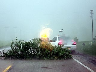
Tree damage and storm chasers dodging debris in the road east of Amboy, Illinois late on June 22, 2016. |
|
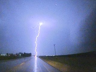
One of many intense CG lightning hits near Ottawa, Illinois after dark on June 22, 2016. |
|
Back-lightning by lightning flash on video frame grab of Seneca, IL tornado on June 22. |
|
Lasalle / Seneca, IL tornado with bright lightning back-light on June 22. Crappy frame-grab from dash-cam video. |
|
Power flashes from the Lasalle / Seneca tornado in Illinois on June 22, 2016. |
|
Better composite view of the Lasalle / Seneca, IL tornado by combining two frames with lightning illuminating the foreground and dimly back-lightning the tornado on June 22. |
|
Large lightning-illuminated tornado in Lasalle County, IL (near Seneca and south of I-80 looking WSW on Highway 6). This was roughly 9:05 CDT on June 22, 2016. |
HTML File "mwcl2016.htm" - Developed By Chris Collura
To Return To The HOME Page Of This Site Click The "INDEX.HTM" Link Here!