
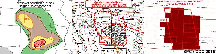
| This section is for storm chases done in the central / Midwestern United States during the year of 2015. This includes all storm chasing activities (including any major chase "expeditions") during the year of 2015 in the central USA (aka "Tornado Alley"). For 2015, all chases in the central USA will be logged in this section, with many of the chases being possible "spot" chases / major severe weather "setups" chased. Here you should find many pictures of lightning, tornadoes, hail, strong winds, along with many severe thunderstorm elements. Keep in mind that this chase log is scientific evidence and portrays my on-going storm chasing research. It has been placed on this page for easy reference and meteorological interests. Please do not plagiarize or copy this document to other sites for distribution. Note - This page may take a while to load on some SLOWER connections! |
STORM CHASING - CENTRAL UNITED STATES - 2015 CHASE LOG
| CHASER NAME | HOME / BASE CITY | CALLSIGN | CHASE DATES | OCCUPATION |
| CHRIS COLLURA | CHICAGO, IL | KG4PJN | 4-7 TO 4-9 | IT CONSULTANT |
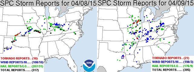
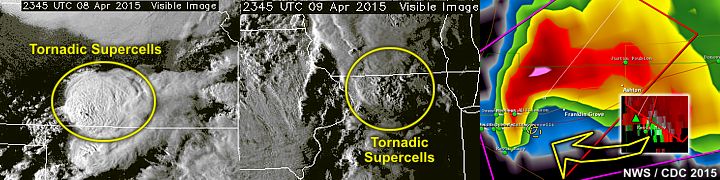
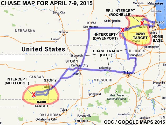
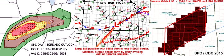
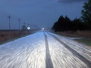
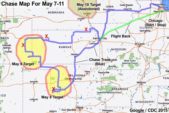
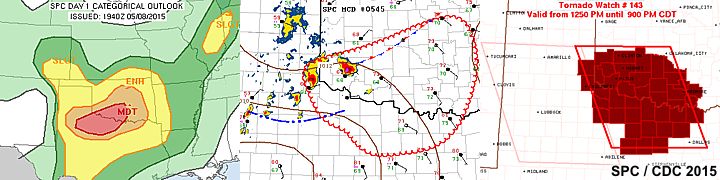
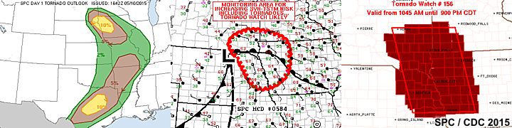
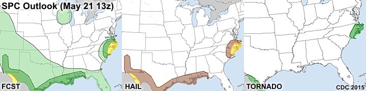
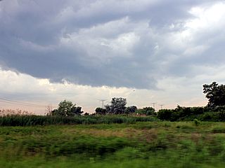
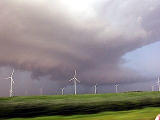
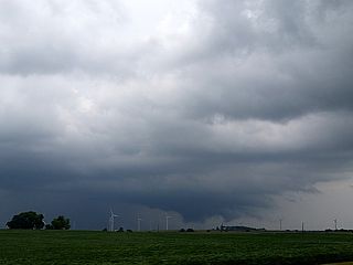
1). April 8, 6:00 PM - Interception and indirect penetration of an extremely severe and tornadic thunderstorm in Barber County, Kansas from west of Medicine Lodge, and north and east towards Nashville, Kansas near Highways 160 and 42. The storm was a classic (and cyclic) supercell thunderstorm. Two tornadoes were observed with this storm, one being a brief low contrast elephant trunk, and another one being a large tornado that lasted about 5 minutes. Fortunately these tornadoes occurred in open rural terrain. The storm had a striking visual appearance, with a striated updraft and multiple layers (like an upside down wedding cake). The storm also produced winds gusting near 50 MPH, and baseball sized hail. Hail to at least 2.5 inches, albeit melted, was observed west of Nashville, Kansas behind the storm as it was weakening. Heavy rains and frequent lightning (with some close hits) was also observed. Hail damage was observed near Nashville. Conditions causing the storms were a warm front / dryline interaction, surface heating, vertical wind shear, a low pressure system, and strong upper trough. Documentation was digital stills, HD video, and audio. A 2009 Ford Escape was used to chase the storms. A tornado watch was also valid for the area until 12 AM CDT the next day.
2). April 9, 6:00 PM - Interception and subsequent penetration of a very severe and tornadic thunderstorm from west of Davenport, Iowa in Scott County, and points east to near I80 and Highway 61 near the Mississippi River. The storm was encountered again west of Fairdale, Illinois in Olga County and near I-39 as it evolved to a line segment behind the other tornadic storm that affected Olga County (below). This storm was an HP supercell storm, and a weak, possibly rain wrapped tornado was briefly visible from the SE side of the storm before it became outflow dominant. The storm also contained frequent lightning, heavy rains, quarter to golfball sized hail, and winds gusting over 70 MPH. The storm was caused by a warm front / Pacific cold front interaction, surface heating, vertical wind shear, a low pressure system, and an intense upper trough aloft. Documentation was digital stills and HD video. A 2009 Ford Escape was used to chase the storms. A tornado watch was also valid for the area until 11 PM CDT.
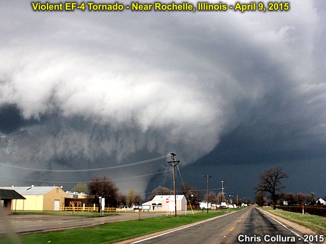
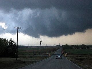
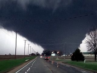
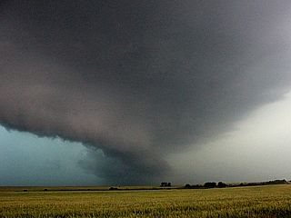
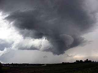
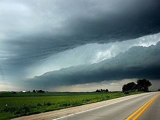
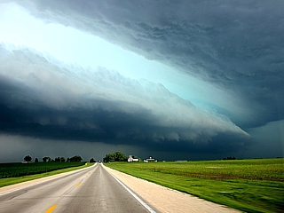
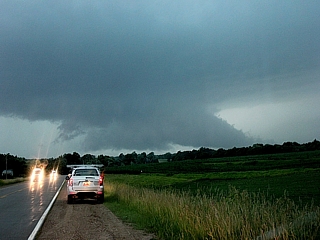
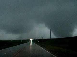
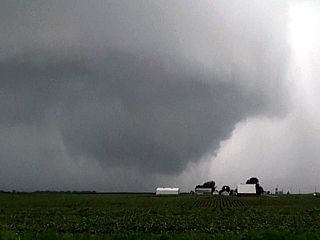
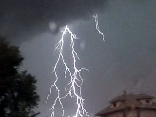
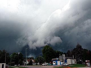
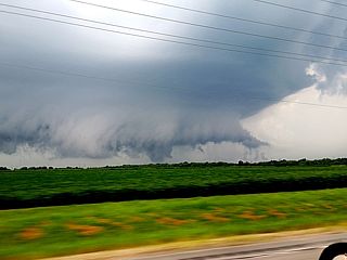
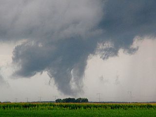
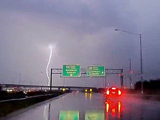
3). April 9, 7:00 PM - Interception and indirect penetration of an extremely severe and violent tornadic thunderstorm in Ogle County, Illinois from north of I-88 near Dixon and towards Rochelle and near I-39 / Highway 251 near Kings and to near Highway 72 near Fairdale. This storm was a violent and cyclic classic supercell thunderstorm. It produced a violent wedge tornado, nearly a mile wide at times that destroyed the small towns of Kings and Fairdale leaving two people dead. The storm developed on the southeastern side and ahead of a cluster of storms, formerly a supercell, to the northwest near Davenport, Iowa. This one cell explosively intensified, and quickly moved to the ENE and NE where it became tornadic near Rochelle and east of Dixon. The tornado started as a cone, then evolved to an elephant trunk, and ultimately a stovepipe. The storm quickly cycled and produced a large and violent (EF-4) tornado northwest of Rochelle just before 7 PM CDT. At one point, the developing wedge had a large satellite (a small stove pipe) tornado rotating around it. This tornado continued until it was out of site to the northeast of Fairdale, where I had to stop and offer assistance (Highway 72 was also blocked there). Ground scouring was noted with the passage of this tornado, along with complete destruction of buildings, homes, trees (with debarking), and vehicles. A semi was overturned by this storm south of Highway 72 on I-39. The ground scouring was along a large swath, oriented SW to NE, with bare dark dirt left. Golfball sized hail was also noted as this storm crossed I-88 earlier. Winds gusting 70 to 80 MPH were observed (RFD) as well as inflow over 60 MPH. Heavy rains and frequent lightning were also encountered. The storm was caused by a warm front / Pacific cold front interaction, surface heating, vertical wind shear, a low pressure system, and an intense upper trough aloft. Documentation was digital stills and HD video. A 2009 Ford Escape was used to chase the storms. A tornado watch was also valid for the area until 11 PM CDT.
This concludes the chase log for the central US Plains and Midwest (including chases in Kansas and Illinois) chase trip for April 7-9, 2015. The summary includes a total of 3 severe thunderstorms, all of which produced tornadoes. 4 tornadoes were observed, two significant (with one of those being violent and causing fatalities). The main chase vehicle conducting this chase was a 2009 Ford Escape. This information was prepared exclusively for the National Weather service and the team of Skywarn storm spotters.
|
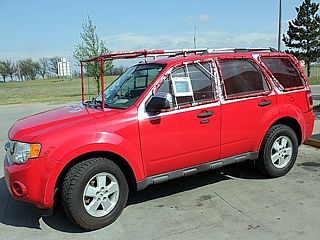
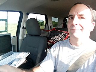
My chase vehicle (2009 Ford Escape) with hail protection in place and ready to start chasing in Kansas (April 8, 2015). |
|
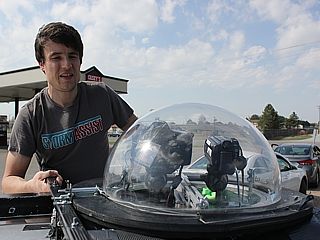
Skip Talbot and his Mesodome (camera housing) atop his chase vehicle near Wellington, Kansas on April 8, 2015. |
|
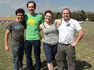
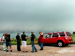
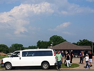
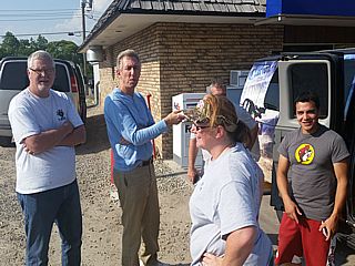
Part of the chaser convergence near Wellington, Kansas on April 8, 2015. Skip Talbot, Blake Naftel, Tony Laubach and many others were there. |
|
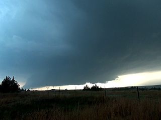
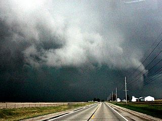
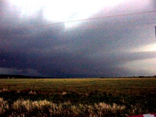
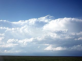
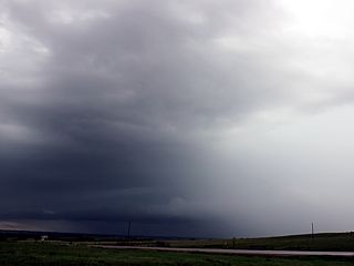
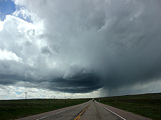
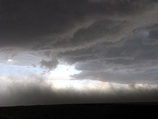
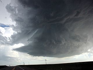
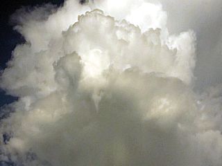
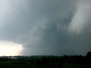
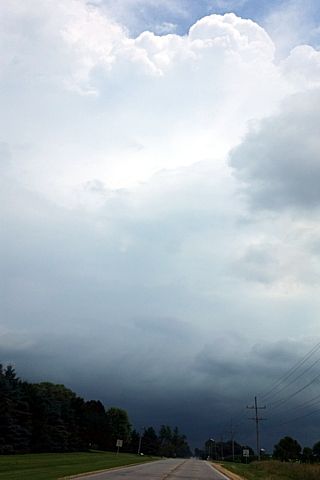
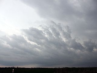
Wall cloud on the Medicine Lodge supercell storm in Kansas on April 8, 2015. |
|
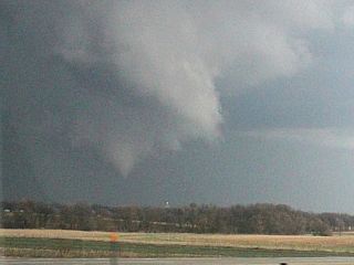
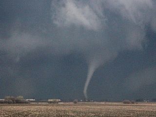
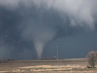
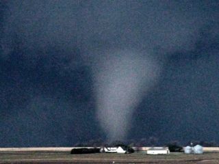
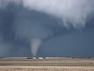
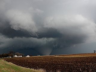
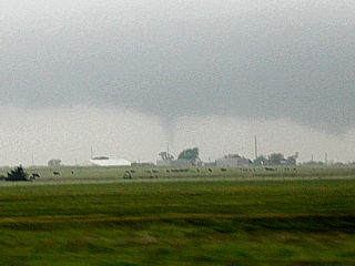
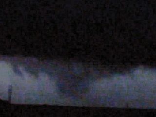
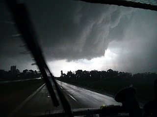
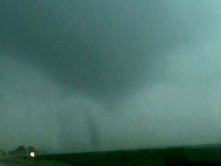
Brief wedge tornado to the southwest of Medicine Lodge, Kansas on April 8, 2015. |
|
Occluding supercell after tornado weakens to the southwest of Medicine Lodge, Kansas on April 8, 2015. |
|
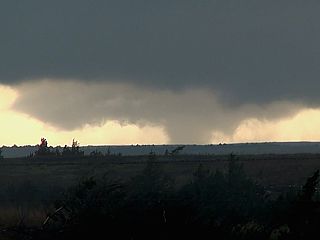
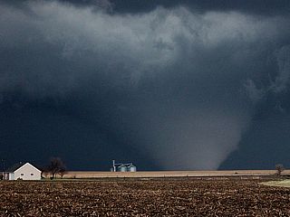
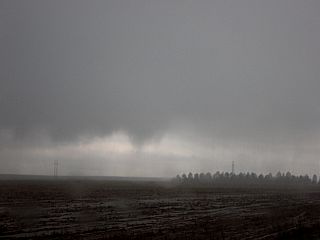
Weakening mesocyclone and low scud clouds southwest of Nashville, Kansas on April 8, 2015. |
|
Looking north at the RFD clear slot and intense mesocyclone southwest of Nashville, Kansas on April 8, 2015. |

|
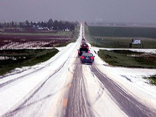
Large hail, partially melted (tennis to baseball sized) near Nashville, Kansas on the evening of April 8, 2015. |
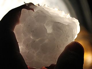
|
Piece of very large hail held up to car headlight. This was one of many pieces covering the ground near Nashville, Kansas on the evening of April 8, 2015. |
|
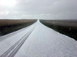
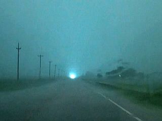
Hail covering roadway near Nashville, Kansas on the evening of April 8, 2015. Note the hail fog forming. |
|
Tornadic HP supercell storm to the west of Davenport, Iowa on April 9, 2015. The weak tornado, to become rain wrapped soon, is to the lower right side of the image. |
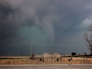
|
Possible weak tornado becoming rain-wrapped to the west of Davenport, Iowa on April 9, 2015. |
|
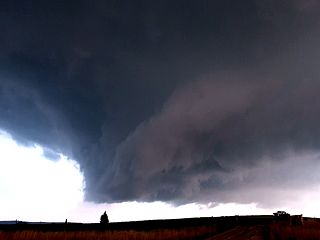
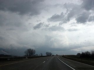
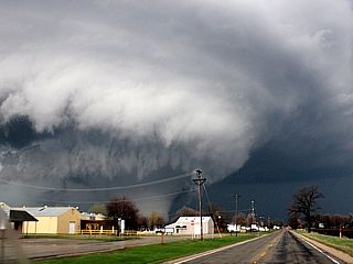
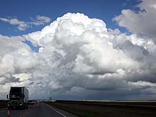
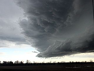
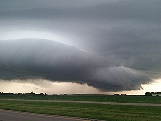
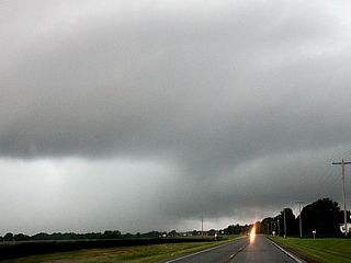
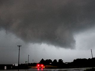
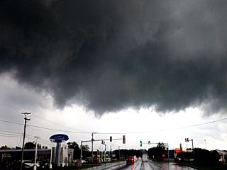
New supercell developing near Dixon, Illinois on April 9, 2015. This will be the violent supercell and tornado to affect the areas north of Rochelle, IL later. The powerful RFD is developing in the center of the image, with flanking line and updraft just right of that. The view is to the east. |
|
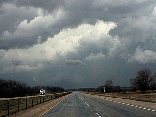
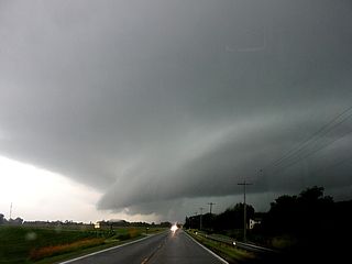
Powerful RFD clear slot develops on a rapidly intensifying supercell storm near Dixon, Illinois on April 9, 2015. The view is east along I-88. |
|
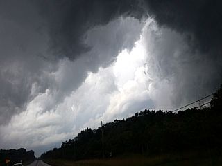
Developing tornado north of I-88 and southwest of Rochelle, IL on April 9, 2015. |
|
Mature elephant trunk tornado north of I-88 and southwest of Rochelle, IL on April 9, 2015. |
|
Stovepipe tornado north of I-88 and southwest of Rochelle, IL on April 9, 2015. The view is to the north. |
|
Close-up view of the large stovepipe tornado north of I-88 and southwest of Rochelle, IL on April 9, 2015. The view is to the north. |
|
Another similar view of the large stovepipe tornado north of I-88 and southwest of Rochelle, IL on April 9, 2015. The view is to the north. |
|
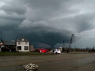
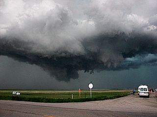
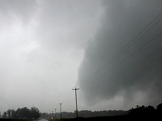
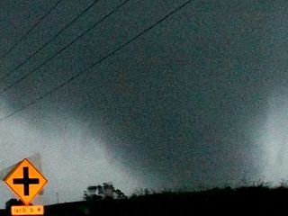
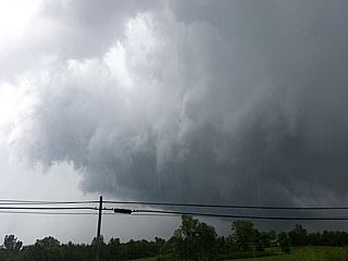
Approaching a violent wedge tornado just west of I-39 near Rochelle, Illinois on April 9, 2015. |
|
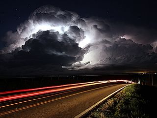
Violent wedge tornado, backlit by a flash of lightning, heading towards Fairdale, Illinois on April 9, 2015. The view is to the north along Highway 251. |
|
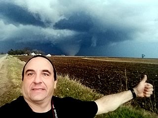
Myself with violent wedge tornado in the background off Highway 251 and north of Hillcrest / Rochelle, Illinois on April 9, 2015. |
|
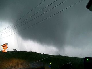
View of violent wedge tornado north of Hillcrest / Rochelle, Illinois on April 9, 2015. |
|
Closer-up view of violent wedge tornado north of Hillcrest / Rochelle, Illinois on April 9, 2015. |
|
Damage in the foreground (Grubsteakers restaurant) near Kings and Fairdale, Illinois with the tornado still on the ground moving into the distance. The view is to the northeast. Some debris, including the sign from this restaurant, was tracked for 80 miles into Wisconsin! |
|
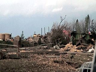
Extensive damage to a farmstead near Fairdale, Illinois on April 9, 2015. |
|
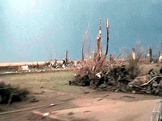
More damage north of Highway 72 and near Fairdale, Illinois. Note the bare dark dirt from the ground scouring in the center of the picture extending left to right. This was late on April 9, 2015. |
|
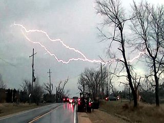
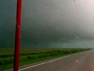
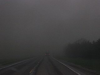
Trees and debris blocking the road as lightning flashes overhead and the chase ends (time to stop and assist) on April 9, 2015 near Fairdale, Illinois. |
|
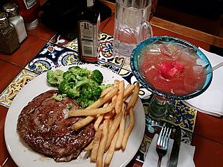
Steak dinner upon returning back to Chicago on April 10, 2015. |
|
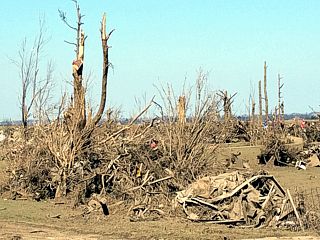
Damage in Olga County (north of Rochelle, IL) on April 11, 2015. |
|
Ground scarring (black line oriented SW to NW) to the west and north of Rochelle / Hillcreast and viewed from PAC 750 skydive aircraft at about 5,000 feet. The view is to the north on April 11, 2015. |
| CHASER NAME | HOME / BASE CITY | CALLSIGN | CHASE DATES | OCCUPATION |
| CHRIS COLLURA | CHICAGO, IL | KG4PJN | 5-7 TO 5-11 | IT CONSULTANT |
1). May 8, 4:30 PM - Interception and penetration of an extremely severe and tornadic thunderstorm from near Davidson, Oklahoma and eastward through Grandfield and Devol from near Highways 183 and 70 in Tillman County. The storm was an HP supercell storm. At least two tornadoes were observed with this storm, one was a brief elephant trunk tornado forming from the left split, and later a low-contrast multi-vortex tornado within the main circulation of the HP storm ("Bears" cage). In addition to the tornadoes, very heavy rains, frequent lightning with some close hits, 60 MPH winds, and tennis ball sized hail was encountered. The main core had baseball sized hail. This storm also had a striking visual appearance. The storm remained over open country, but some flash flooding was noted with the passage of this storm. Conditions causing the storm were a low pressure system, stationary frontal boundary, surface heating, and an upper trough. Documentation was audio, digital stills, and HD video. A 2009 Ford Escape was used to chase the storms. A tornado watch was also in effect for the area until 9 PM CDT.
2). May 9, 6:00 PM - External observation of an extremely severe and cyclic tornadic supercell storm from along Highway 385 in Cheyenne Wells in Cheyenne County, Colorado. This storm was not reached until it weakened near Burlington and I-70 and was outflow dominant. None of the tornadoes were observed as a navigation issue / fuel stop caused problems getting into position on the storm on time. Hail was observed covering the ground (marble sized) with an occluded wall-cloud and a temperature drop from the mid 70's to near 40 degrees (F)! The storm was also a low topped type of cold core storm. Conditions causing the storm were a low-pressure system, dryline, warm front, surface heating, and upper trough / low. Documentation was digital stills, and HD video. A 2009 Ford Escape was used to chase the storms. A tornado watch was also in effect for the area until 9 PM MDT.
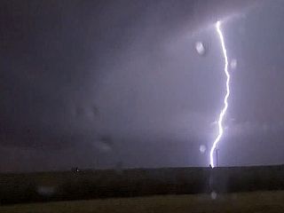
3). May 9, 9:30 PM - Observation of an extremely severe and cyclic tornadic supercell storm from along Interstate 70 and Grinnel, Kansas in Gove County. The storm was not directly penetrated, but large tornadoes, illuminated by continuous lightning, were observed with this storm. The storm was also a low topped type of cold core storm. Conditions causing the storm were a low-pressure system, dryline, surface heating, and upper trough / low. Documentation was digital stills, and HD video. A 2009 Ford Escape was used to chase the storms. A tornado watch was also in effect for the area until 10 PM CDT.
4). May 10, 12:30 PM - Observation of a disorganized but marginally severe storm passing through Nemaha County near Oneida, Kansas and along Highway 36. The storm was a multicell severe storm, and small marble sized hail was observed on the ground after the storm passed. The core was not directly penetrated. Conditions causing the storms were a low level jet, surface heating, a low pressure trough, and an upper trough. Documentation was digital stills. A 2009 Ford Escape was used to chase the storms. A severe thunderstorm watch was also in effect for the area until 10 PM CDT.
This concludes the chase log for the central US Plains and Midwest chase trip for May 7-11, 2015. The summary includes a total of 4 severe thunderstorms, three of which produced tornadoes. 4 tornadoes were observed in total. The main chase vehicle conducting this chase was a 2009 Ford Escape. This information was prepared exclusively for the National Weather service and the team of Skywarn storm spotters.
|
Hail grills installed on chase vehicle (Ford Escape) prior to the chase trip for May 7-11, 2015. |
|
Brief tornado on the northern (left) split of an HP supercell southwest of Frederick, Oklahoma on May 8, 2015. |
|
View southwest at massive wall cloud and HP supercell storm. A possible tornado (barely visible) is in the center of the image just above the ground. This is along Highway 183 in Oklahoma just north of the Red River / Texas border on May 8. |
|
View of occluding RFD (left) and FFD (right) with notch area and wall cloud (center) of the HP supercell storm near Grandfield, OK on May 8. |
|
Inside the "bear's cage" of the HP supercell storm near Grandfield, OK on May 8. Brief multi-vortex tornado barely visible just left of the center of the picture looking WSW. |
|
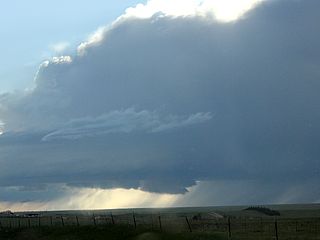
Low topped LP supercell off Highway 385 looking northeast while trying to catch up with a tornadic storm farther north in SE to E Colorado on May 9, 2015. |
|
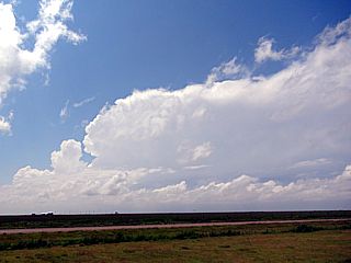
View of the Cheyenne Wells, Colorado supercell from about 30 miles out on May 9. Hard to believe this "low topped" storm produced a half dozen tornadoes. |
|
Hail covers the ground (marble sized) south of Burlington, CO along highway 385 on May 9. Note the "traffic jam" of storm chasers! |
|
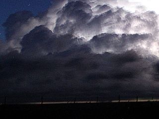
This is a time exposure of the Grinnell, Kansas cyclic tornadic supercell after dark on May 9. Lightning was continuous enough to illuminate the entire structure of this low topped supercell. To the lower left a large tornado can barely be made out under the storm base! |
|
Even from 30 miles away, the lightning reveals a large tornado (or a tornado and a satellite) under the base of the storm. In this image, two tornadoes can easily be seen to the lower right side of the image! |
|
Earlier view (poor quality from a video frame grab) of one of the large tornadoes looking NW from east of Grinnell, Kansas on May 9 at roughly 10 PM CDT. |
|
Disorganized severe storm in messy morning convection passing through northeastern Kansas on May 10, 2015. This was pretty ,uch a cencelled chase day, with anything good for the day developing far away. |
|
Throw-back picture at the end of the chase showing the Grandfield, OK storm with my vehicle and a chaser convergence off highway 70 in Oklahoma. I left my vehicle at the airport on May 11 and flew back to Chicago instead. I left my vehicle there in long term parking so I can pick up chasing again on my main trip a week later. |
| CHASER NAME | HOME / BASE CITY | CALLSIGN | CHASE DATES | OCCUPATION |
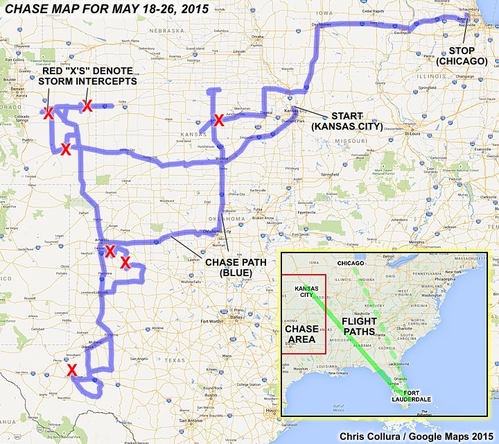
| CHRIS COLLURA | CHICAGO, IL | KG4PJN | 5-18 TO 6-1 | IT CONSULTANT |
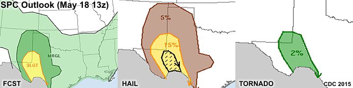
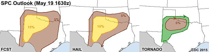
1). May 19, 4:30 PM - Interception and penetration of a very severe and possibly tornadic thunderstorm in Armstrong County, Texas between Canyon and Claude along FM 1151. The storm was an HP supercell storm. Conditions encountered were occasional lightning, torrential rains, 60 to 70 MPH winds, and hail up to quarter sized (mainly marble sized in large amounts). A rotating wall cloud / small funnels was also noted with the updraft of this storm. The storms were caused by an advancing dryline, low pressure area, surface heating, boundary interactions, and an upper trough. Documentation was digital stills and HD video. A 2009 Ford Escape was used to chase the storms. The area was to the west of a tornado watch valid until 9 PM CDT.
2). May 19, 7:00 PM - Interception and penetration of another very severe and possibly tornadic thunderstorm in Donley County, Texas near Highway 70 and south of Clarendon and west of Lakeview on 256. The storm was a large HP supercell storm. Conditions encountered were frequent lightning (with some close hits), torrential rains, winds gusting near 70 MPH, and occasional hail up to quarter sized (the main core was not penetrated). A large rotating wall cloud / small funnels was also noted with the updraft of this storm, with some tagging rain curtains. The storms were caused by an advancing dryline, low pressure area, surface heating, boundary interactions, and an upper trough. Documentation was digital stills and HD video. A 2009 Ford Escape was used to chase the storms. The area was to the west of a tornado watch valid until 9 PM CDT.
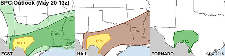
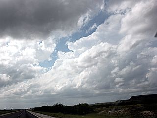
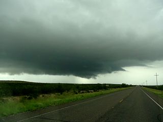
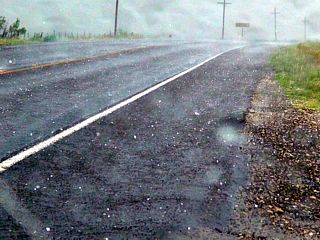
3). May 20, 5:00 PM - Interception and penetration of a severe thunderstorm in Pecos County, Texas near Highway 18 and just north of Fort Stockton. The storm was an LP (to classic) supercell storm. Conditions encountered were occasional lightning (with a couple close hits), heavy rains, winds gusting near 50 MPH, and hail up to quarter sized. A rotating wall cloud was also noted with the updraft of this storm, with some small funnels. The storms were caused by an advancing dryline, low pressure trough, surface heating, southward moving cold front, and an upper trough. Documentation was digital stills and HD video. A 2009 Ford Escape was used to chase the storms. A severe thunderstorm watch was also valid for the area until 12 AM CDT the next day.
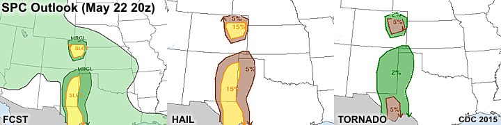
4). May 22, 4:30 PM - Interception and penetration of a strong to severe thunderstorm in Elbert County, Colorado near Matheson and along Highway 24, then near 40 towards Hugo and south of Limon. The storm began as an LP supercell storm, and evolved to classic / multicell at times. The storm had a striking visual appearance, and some small funnels were noted with the storm as well. Small hail was also noted covering the ground. There was occasional lightning, 50 MPH winds, heavy rains, and small hail. Conditions causing the storms were surface heating, a warm front, low pressure system, and upper trough. Documentation was digital stills and HD video. A 2009 Ford Escape was used to chase the storms.
5). May 22, 7:00 PM - Interception and observation of a severe thunderstorm in Kit Carson County, Colorado near I-70 and Burlington to Bethune. The storm was a supercell storm with strong rotation observed on its southeastern side, with 50 to 60 MPH inflow winds. The core was not directly penetrated, but heavy rains, small hail, lightning, and 50 MPH winds were observed. A rotating wall cloud and some funnel clouds were also observed with this storm. Conditions causing the storms were surface heating, a warm front, low pressure system, and upper trough. Documentation was digital stills. A 2009 Ford Escape was used to chase the storms.
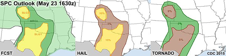
6). May 23, 4:30 PM - Interception and penetration of strong to severe thunderstorms near Otero County, Colorado from near La Junta and Highway 50 to near and north of Las Animas. The storm was a small supercell storm that evolved to a cluster / bow segment of multicell storms. A rotating wall cloud and some funnels were observed, as well as lightning, heavy rains, hail to 1", and winds gusting over 60 MPH. Conditions causing the storms were surface heating, low pressure system, and upper trough. Documentation was digital stills and HD video. A 2009 Ford Escape was used to chase the storms. A tornado watch was also valid for the area until 7 PM MDT.
7). May 25, 5:00 PM - Interception and penetration of severe thunderstorms near Saline County, Kansas from near Salina and points northeast along Interstate 70. The storms were a multicell cluster of severe storms, but an LP supercell storm with a rotating wall cloud was observed on the northern side of the storm complex. The multicell cluster of severe storms eventually overtook the LP storm, and had 60 MPH winds, heavy rains, frequent lightning (with some close hits), and hail up to quarter sized (1 inch or so).Conditions causing the storms were surface heating, a low pressure system, frontal boundary, and upper trough. Documentation was digital stills and HD video. A 2009 Ford Escape was used to chase the storms. A severe thunderstorm watch was also valid for the area until 10 PM CDT.
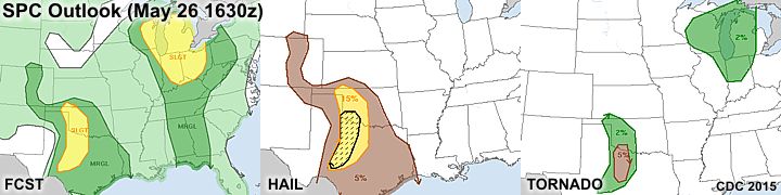
This concludes the chase log for the central US Plains and Midwest chase trip for May 18 to May 26, 2015. The summary includes a total of 7 severe thunderstorms. No tornadoes were observed on this trip. The main chase vehicle conducting this chase was a 2009 Ford Escape. This information was prepared exclusively for the National Weather service and the team of Skywarn storm spotters.
|
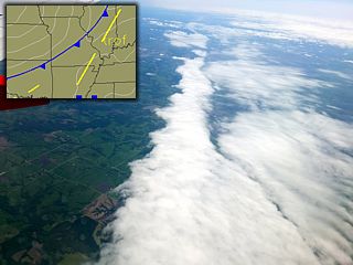
Flying into Kansas City to pick up my vehicle there from the week prior and start my trip on May 18. While overflying Missouri, the unmistakable line of the cold front can be seen below us (note the upper-left inset from NCAR at the time). |
|
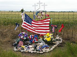
Paying tribute to Tim and Paul Samaras, and Carl Young, who perished in the May 31, 2013 El Reno tornado. A beautiful memorial is still maintained for them along side Reuter Road in rural Oklahoma. Always keep these folks in our hearts on EVERY chase trip. |
|
Developing supercell storm along the dryline west of Canyon, Texas on May 19, 2015. |
|
RFD and wall cloud looking north in Canyon, Texas. |
|
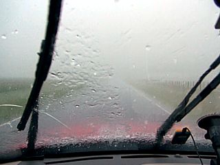
Punching through hail core with 60+ MPH winds and marble hail on Claude Road east of Claude, Texas. |
|
Rotating wall cloud before being under cut by FFD / cold air looking SW. This was SW of Claude, Texas. |
|
Another supercell later develops to the southwest and takes a path south of the previous one that affected Claude, Texas. This one had an incredible radar signature as it was over the Palo Duro Canyon and west of Clarendon, Texas on May 19! |
|
The view of the same "hook" you see in the radar image above, while heading down highway 70 out of Clarendon, Texas. |

|
The storm looked impressive on radar, but did not produce any tornadoes, just lots of low-level rotation. This is a view of the wet RFD approaching highway 70 between Clarendon and Memphis, Texas from in the "bears cage" of the storm. |
|
Weakening supercell storm at sunset while headed back to Lubbock, Texas for the night. |
|
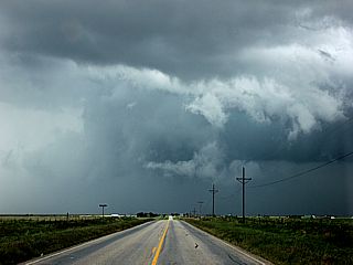
A developing supercell storm north of Fort Stockton, Texas from heading west on I-10 on May 20, 2015. |
|
Low level mesocyclone of the supercell storm north of Fort Stockton, Texas on May 20. |
|
Hail up to quarter sized falling along Highway 18 north of Fort Stockton, Texas. |
|
This place is a MUST when storm chasing and stopping in Amarillo, Texas for the night! The Big Texan Steakhouse, with many chase vehicles parked in the parking lot as well. |
|
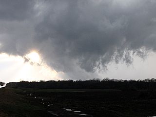
Initiation of severe storms in the target area in Colorado (this cell is SW of Limon). |
|
Developing LP supercell storm near Matheson, Colorado (SW of Limon) on May 22, 2015. |
|
Hail covers roadway after passage of LP supercell north of Hugo, Colorado. |
|
Another developing supercell storm looking east along I-70 towards Burlington, Colorado late in the day on May 22. |
|
Rapidly rotating area of supercell storm near Burlington, Colorado. |
|
Small funnel on rotating area of supercell storm west of Burlington (near Bethune), Colorado. |
|
Wall cloud on low-topped LP supercell storm near Flagler, Colorado. |
|
HP type "notch" of supercell storm being embeeded in developing bow segment near Las Animas, Colorado on May 23, 2015. |
|
North edge of wall cloud with chasers along highway 14 near Haswell, Colorado on May 23. |
|
Briefly rotating wall cloud, with possible gustnadoes underneath, before being rapidly undercut by outflow near Carlton, Colorado. |
|
Impressive shelf cloud along the gust front east of Carlton, Colorado as storms become outflow dominant. |
|
Although not the best choice for May 24, 2015 ... I took this as a down day and had some needed maintenance done to my chase vehicle. |
|
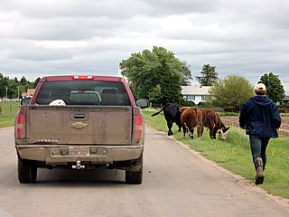
Some cows were loose near Courtland, Kansas while on route to the target area for the day. |
|
Small (LP) supercell storm with wall cloud forming near Salina, Kansas during the afternoon of May 25, 2015. |
|
Another view of the LP supercell storm and RFD clear slot / wall cloud. |
|
Backside of shelf cloud and "whales mouth" over central Iowa while driving back from Des Moines to Chicago associated with a morning MCS. |
| CHASER NAME | HOME / BASE CITY | CALLSIGN | CHASE DATES | OCCUPATION |
| CHRIS COLLURA | CHICAGO, IL | KG4PJN | 6-1 TO 6-5 | IT CONSULTANT |
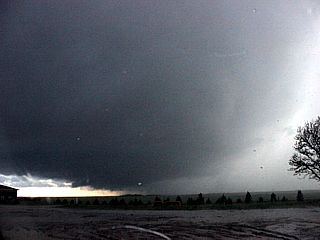
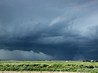
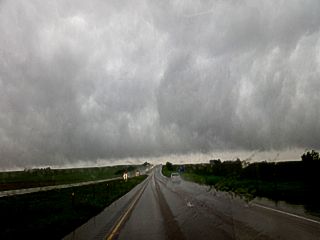
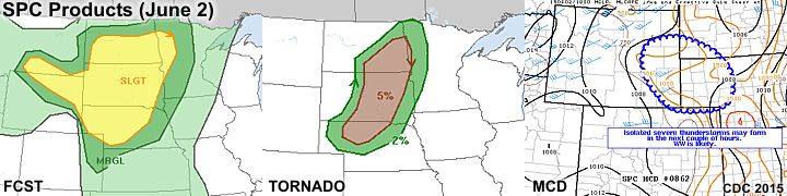
1). June 2, 5:30 PM - Interception and observation of a very severe thunderstorm in Dawes County, Nebraska from west of Highway 385 and north of River Road near Marshland. The storm was a multicell cluster of strong and severe thunderstorms that evolved into a high precipitation supercell, then became outflow dominant with strong winds and dust (a "haboob"). The storm core was not penetrated, but small hail and winds gusting over 60 MPH were encountered with lightning and rain. A large, rotating wall cloud and RFD clear slot (wet RFD) was noted with a brief and large funnel cloud. Conditions causing the storms were surface heating, a low pressure system, dryline / boundary interactions, and an upper trough. Documentation was digital stills and HD video. A 2009 Ford Escape was used to chase the storms. A severe thunderstorm watch was also in effect for the area until 10 PM MDT.
2). June 2, 7:30 PM - Interception and observation of a severe thunderstorm in Morrill County, Nebraska from near highways 385 and 26 as well as south of there near Bridgeport and Highway 88. The storm was an LP supercell storm. The storm core indirectly penetrated, and hail to 1" was observed. Some dust, winds near 50 MPH, moderate rain, and lightning were also observed. The storm had a striking visual appearance ("stacked plates" effect). The storm undergone downscale evolution revealing a "barber pole" updraft as it weakened amidst other LP storms that formed west and north of it. Conditions causing the storms were surface heating, a low pressure system, dryline / boundary interactions, and an upper trough. Documentation was digital stills and HD video. A 2009 Ford Escape was used to chase the storms. A severe thunderstorm watch was also in effect for the area until 10 PM MDT.
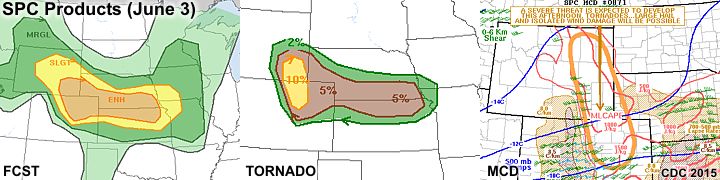
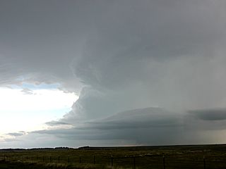
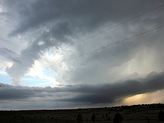
3). June 3, 7:30 PM - Interception and observation of a severe thunderstorm in Ramah County, Colorado from between Kiowa and Agate and west of I-70 and north of highway 86. The storm was a supercell storm (classic to HP), with a striking visual appearance. The core, with baseball sized hail, was not penetrated. A rotating wall cloud was noted looking WSW into the storm, with a large funnel / possible brief tornado. The storm remained over open rural country, otherwise just light rain, 40 MPH winds, small hail, and lightning were observed from my part. Conditions causing the storms were surface heating, a low pressure system, upslope wind flow, and an upper trough. Documentation was digital stills. A 2009 Ford Escape was used to chase the storms. A tornado watch was also in effect for the area until 9 PM MDT.
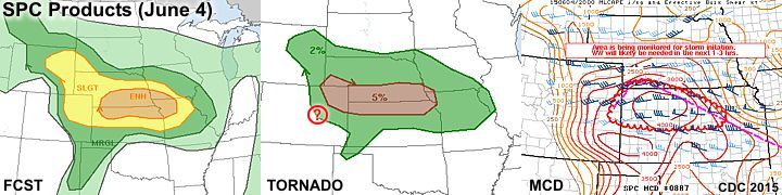
4). June 4, 9:30 PM - Penetration of strong to severe thunderstorms along Interstate 80 from near Grand Island and eastward in Hall County, Nebraska. The storms were a multicell cluster / line of thunderstorms, and were outflow dominant. A shelf cloud was noted with the gust front from these storms, and winds near 60 MPH, small hail, torrential rains, and frequent lightning was observed. Conditions causing the storms were surface heating, boundary interactions, and an upper trough. A 2009 Ford Escape was used to chase the storms.
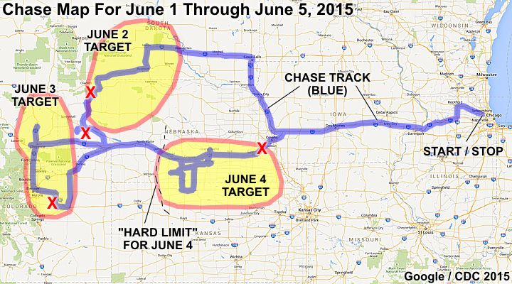
This concludes the chase log for the central US Plains and Midwest chase trip for June 1 to June 5, 2015. The summary includes a total of 4 severe thunderstorms. Once again, the bad luck of no confirmed tornadoes were observed on this trip. The main chase vehicle conducting this chase was a 2009 Ford Escape. This information was prepared exclusively for the National Weather service and the team of Skywarn storm spotters.
|
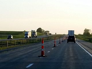
Heading west on I-80 through Iowa late on June 1 after work. Unfortunately, the only "cones" to be bagged on this trip out would be mostly traffic cones, as late-spring road contruction was quite widespread on many highways and interstates. |
|
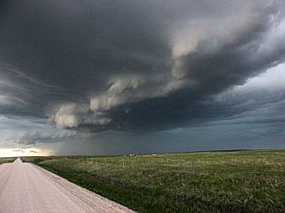
This is an intense line segment / multicell storms evolving to HP supercells near Chadron, Nebraska on June 2, 2015. The mesocyclone is developing in the center of the picture. |
|
Closer view looking WNW towards a developing supercell storm, with the RFD and mesocyclone (with wall cloud and funnel forming in the upper center-right of the picture). This was June 2 near Chadron, NE and Marshland and west of highway 385. |
|
Powerful RFD gust front forming as the supercell storms near Marshland, NE undergo up-scale evolution and start to become outflow dominated. June 2, 2015 west of highway 385. |
|
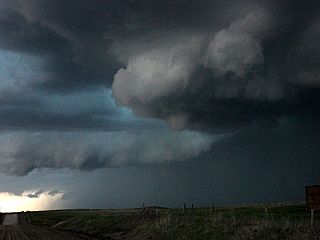
A large wall cloud and funnel develops with the HP supercell storm just before being undercut with outflow as the tour groups watch. This was June 2 west of highway 385 in Dawes County, NE and north of highway 2. |
|
As the supercell storms near Dawes County, NE evolved into an intense line segment, outflow dust was kicked up causing a "haboob" (dust storm). June 2 near highway 385. |
|
Near zero visibility inside the dust storm (outflow "haboob") near Highway 2 and 385 in Dawes County, NE. |
|
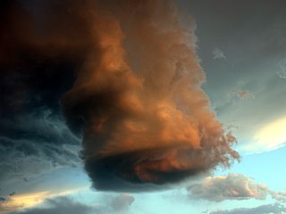
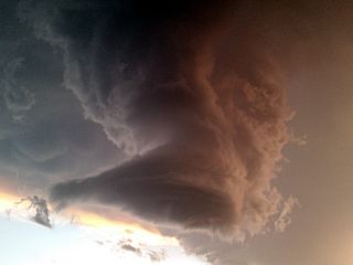
LP supercell storm near Morrill County, NE farther south and near highways 385 and 26. |
|
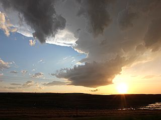
Later view of a down-scaling LP supercell west of Dalton, NE near SR 88 at sunset on June 2. |
|
Remnant updraft of LP supercell NE of Dalton, NE undergoing down-scale evolution with a narrow "barber-pole" structure at dusk. The orange color is from the setting sun on June 2. Quarter sized hail was still falling at this point. |
|
Final view of weakening LP storm and "barber-pole" updraft before dissapation late on June 2 and NE of Dalton, NE. |
|
Denver rush hour traffic encountered attempting to leave the Cheyenne, WY area down I-25 to I-70 east to target supercell storms to the ESE of Denver, Colorado on June 3. This was the only option to avoid missing any storms. Do not try to chase in Denver proper during rush hour! |
|
Approacing an intense supercell storm over the Palmer Divide southeast of Denver and west of Limon, Colorado on June 2. |
|
Another view of the supercell storm west of Agate / Limon, Colorado on June 3. Note the intense rotation extending past the cloud boundary and causing clouds away from the storm to form "rings" (line rings around a planet)! Beaver's tail extends from center to lower right with an intense hail core. |
|
I am not sure what to call this, scud or a weak tornado? This was west of Agate, CO on June 2 just before an HP supercell storm over the Palmer Divide weakened. The view is due west at the wall cloud. |
|
Another view of a supercell storm developing after sundown over Denver, Colorado from about 50 miles away near Last Chance, CO on highway 71. |
|
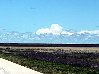
Elevated (high based) showers and thunderstorms over Grand Island, NE while headed east on I-80 during the morning of June 4. These rather harmless storms are marginally severe with air parcels feeding into them from an unstable layer aloft (elevated) while the air near the ground is still stable. |
|
Part of a very large chaser "convergence" in Phillipsburg, Kansas near highways 183 and 36. The sky is becoming convective above as Tempest Tours here waits for initiation. Chuck Doswell is the one with the hat standing in the center of the crowd. |
|
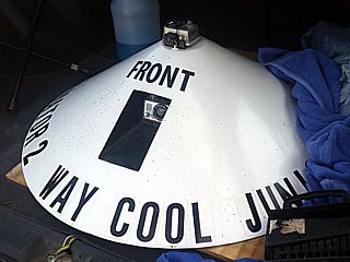
The Outlaw Chaser's "Caminator 2" tornado video probe. This is the same unit that got exceptional footage from one of the Pilger Tornadoes in June 2014. |
|
Many storm chasers waiting for storms to go up in a gas station at Phillipsburg, Kansas on June 4. |
|
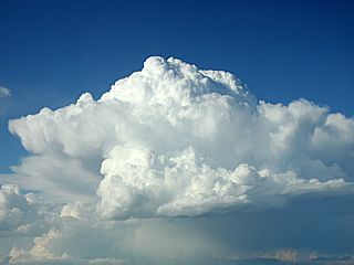
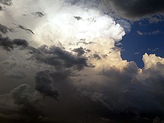
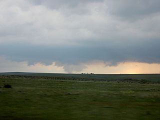
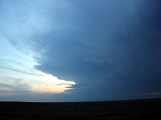
Finally a welcome sight! A nice cumulus tower rapidly develops and right away begins rotating with an impressive LP appearance for such a small convective cell. This was late on June 4 over Phillipsburg, Kansas. |
|
To the dismay of many chasers, the want-to-be supercell storm cannot fight the capping inversion and shear, and shrivels up leaving an orphan anvil behind. A small high-altitude funnel appears on the orphan anvil. This area remained capped afterwards. |
|
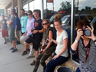
Some more chasers, from left to right: Charles Edwards (Cloud9 Tours), Rocky Roscovich, Gene Robertson and his wife, and Scott Peake (with Extreme Chase Tours). |
|
Myself not in a good mood. I could not go farther west with nearly every chaser (at the Phillipsburg "convergence") who scored big with beautiful LP storms 80 miles west near Atwood, Kansas later in the day on June 4 near dusk. I had to head back for work committments and I am heading up highway 183 back into Nebraska to take I-80 back east. This was before the real "salt" in the wounds, when I found out what happened in Colorado in the exact same place I was in less than 24 hours prior! |
|
Not much of a colsolation was encountered back east passing through Grand Island and Lincoln, NE along I-80 after dusk on June 4. This was a line segment of severe thunderstorms, and a pretty shelf cloud associated with them. |
|
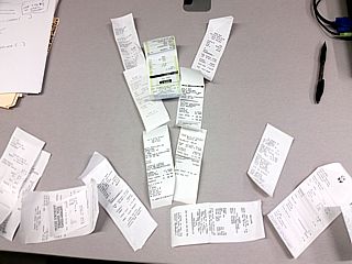
Since this trip was mainly a failure at seeing tornadoes, I took my receipts - Pretty much all I had to show besides structure shots - and arranged them upon my desk (while back at work that morning) in the shape of a tornado. |
1). Feb 1, 5:00 PM - Observation of the coastal (Lake Michigan) effects and impacts of a powerful extratropical storm, and blizzard conditions, in Cook County, Illinois and in the Chicago area from near Montrose to Fullerton and around Lakeshore Drive. The conditions encountered were winds gusting over 50 MPH with near zero visibility, with blowing and drifting snow. Maximum accumulation was over 19 inches, being one of the top blizzards to affect the Chicago area in several years. Some power outages were observed, along with numerous vehicles stranded and accidents. The snow was blinding, and large waves battered the lakefront as well. The conditions were caused by an intensifying extratropical storm passing near and to the south of the Chicago area, with the backside (cold sector) of the storm affecting the area with a large arctic (Canadian) high pressure to its northwest. A strong jet stream and upper trough was also present aloft. A 2013 Ford Focus was used in the observation. Documentation was HD video and digital stills. A blizzard warning was also in effect for this area until Feb 2.
2). June 10, 7:30 PM - Observation of very severe thunderstorms (from a distance of about 25 miles) late in the day from Cook County, Illinois. The storms were near Joliet / Minooka and the storms produced heavy rains and hail up to 4.25" (grapefruit sized) near Minooka at the time. The storms were not penetrated, just observed from a distance, with a display of incredible mammatus and updraft / storm structure. Conditions causing the storms were surface heating, boundary interactions, and an upper trough. A 2009 Ford Escape was used to chase the storms.
3). June 20, 1:30 PM - Interception and penetration of a severe thunderstorm near Tipton, Iowa in Cedar County and along Highway 30. The storm was an elevated line segment of strong and severe storms. Very heavy rains, lightning, 60 MPH winds, and hail to 1" were encountered with this storm. The storms were caused by a surface boundary to the south, surface heating, and an upper trough. Documentation was still digital photos. A 2009 Ford escape was used to chase the storms.
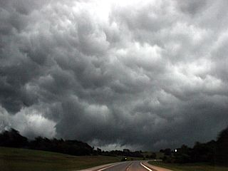
4). June 20, 7:00 PM - Observation and penetration of very severe thunderstorms from near Pella and Oskaloosa, Iowa in Marion County near Highway 163, and points southeast and east along Highway 63 and 34 into Mount Pleasant and Henry County. The storm was initially a multicell cluster of severe storms, with 2 embedded HP supercells. A large wall cloud and some rotation was noted at this point. Hail to 1.5", frequent lightning with close hits, torrential rains, and 70 MPH winds were observed at this point. The storm supposedly had hail approaching grapefruit sized, so the worst part of the core was not penetrated. The storms evolved into a derecho-like bowing MCS, which raced east and had winds gusting over 75 MPH. The storms were caused by surface heating, a cold front, and an upper trough. Documentation was digital still photos and HD video. A 2009 Ford Escape was used to chase the storms. A tornado watch was also valid for the area until 10 PM CDT.
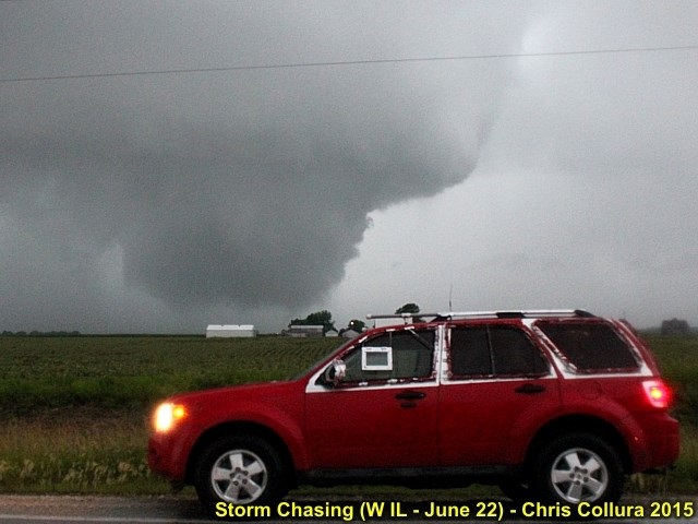
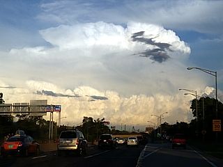
5). June 22, 7:15 PM - Interception and penetration of an extremely severe and tornadic thunderstorm from east of Muscatine, Iowa across the river in Illinois, and from near Illinois City along highway 92 / 192 and points east and southeast towards Alpha and Woodhull along Highway 67 and eventually I-74 and highway 17 / 34 north of Altona mainly in Rock Island County. The storm was a cyclic HP supercell storm, and produced at least 2 tornadoes during its cycles in Illinois (possibly another before crossing the Mississippi river in Iowa). One of these tornadoes was observed at close range. The tornado in a heavy rain wrap ("bear's cage") region and was a multi-vortex that evolved to a stovepipe / cone, then a wedge tornado. The tornado became rain wrapped and remained over rural areas, damaging some farm equipment and downing power poles (power flashes seen). RFD winds gusting to near 80 MPH with small hail and horizontal violent rain was also encountered. A second possible tornado, with impressive "stacked plates" supercell structure was observed farther southeast near Woodhull along Highway 67. The storm had frequent lightning with numerous close hits. The storm was caused by surface heating, a pre-frontal convergence area (ahead of Pacific cold front), outflow boundary, and an upper trough. Documentation was digital still photos and HD video. A 2009 Ford Escape was used to chase the storms. A tornado watch was also valid for the area until 11 PM CDT.
6). June 24, 7:00 PM - Interception and observation of very severe and possibly tornadic thunderstorms from northwest of Winterset, Iowa and near Greenfield in Madison County near Highway 169 and south of I-80, and points southeast and east through Osceola on Highway 34. The storm was a cluster of HP supercells, one having strong rotation and a striking "multi-tiered" shelf cloud and impressive visual presentation. The storms evolved to an intense multicell cluster with embedded supercells. An area of very strong rotation (wall cloud and RFD clear slot) was noted near Greenfield before outflow undercut the storms. Other conditions were frequent lightning, very heavy rains, 60 to 65 MPH gusts, and small hail. The main storm cores were not penetrated. The storms were caused by surface heating, boundary interactions, a lower pressure trough, and an upper trough. Documentation was digital still photos and HD video. A 2009 Ford Escape was used to chase the storms. A tornado watch was also valid for the area until 2 AM CDT the next day.
7). July 17, 5:15 PM - Penetration of a strong to marginally severe thunderstorm from near Highways 72 and 25 in east Dundee, IL and points south to near Elgin, IL in Kane and Cook Counties. The storm was part of a cluster / line segment of thunderstorms. Some lightning, 50 MPH wind gusts, small hail to dime sized, and very heavy rains were encountered with this storm. Some traffic signals were out and street flooding was also observed. The storms were caused by surface heating, boundary interactions, and an approaching upper trough. Documentation was digital still photos. A 2009 Ford Escape was used to chase the storms.
8). July 18, 2:30 PM - Interception and observation of a very severe and tornadic thunderstorm between Hebron and Harvard in McHenry County, Illinois from north of Highway 14 and west of Highway 47. The storm was a supercell storm that developed initially on the south side of a cluster of strong and severe thunderstorms. This classic to HP storm developed a weak tornado over rural areas of McHenry County, with circulation extending to ground level with airborne tree debris and a visible funnel above it. The tornado did damage mainly to trees and a destroyed barn / shed. A well defined RFD clear slot and wall cloud was also noted with this tornadic supercell. The storm quickly merged with other storms afterwards and evolved to a multicell cluster. Frequent lightning, with some close hits, 50 to 60 MPH wind gusts, small hail, and very heavy rains were also encountered with this storm. The main core was not penetrated. The storm was caused by surface heating, a well-defined NW to SE oriented outflow / lake breeze boundary, a low pressure trough, warm front, and upper trough. Documentation was digital still photos and HD video. A 2009 Ford Escape was used to chase the storms. A tornado watch was also valid for the area until 10 PM CDT.
9). Aug 2, 9:00 PM - Observation of severe thunderstorms including a tornadic supercell storm ahead of the storm cluster. This was anywhere from Cook / Lake counties in Illinois to earlier storms to the SW near DuPage county. The storms were north and northwest of Chicago and produced large hail and wind damage. A tornado was also reported in Lake county, then offshore in lake Michigan as a waterspout. The storm was extremely active electrically. The tornado was not observed. Heavy rains, small hail, 50 mph winds, and frequent lighting was encountered with the indirect penetration of the storm cluster. The storms were caused by a frontal zone, surface heating, boundary interactions, and an upper trough. A 2009 ford Escape was used to chase the storms. A severe thunderstorm watch was also valid until.2 AM CDT.
10). Aug 18, 5:15 PM - Interception and observation of a severe and tornadic thunderstorm near Livingston and Grundy Counties in Illinois from near Highway 17 and 47 west of I-55 southwest of Dwight and Mazon. Two supercell thunderstorms developed ahead of a multicell storm cluster to the west, and these storms were targeted as they moved from near Livingston County, northeast towards Grundy, and eventually southern Cook County. A large rotating wall cloud, impressive structure (with striations), and a brief tornado were observed with the northern of these two supercells (HP to classic in nature). Both storms were tornado warned. The core was not penetrated, but 50 MPH winds, frequent lightning, heavy rains, and small hail was observed. No damage was noted as the storms occurred over rural areas. Conditions causing the storms were a low pressure trough, surface heating, boundary interactions, and an upper trough. Documentation was digital stills and HD video. A 2009 Ford Escape was used to chase the storms. A tornado watch was also valid for the area until 10 PM CDT.
11). Oct 3, 11:00 AM - Coastal observation of strong winds and high waves on Lake Michigan near the south side of Chicago along Lakeshore Drive. Strong winds gusting 30 to 40 MPH, and waves 5 to 8 feet were observed on the lakefront, crashing over the sea walls in some places. The strong winds were caused by a very large trough of low pressure over the eastern USA and Canada, and strong high pressure to its northwest (mainly affecting coastal NE USA). A 2009 Ford Escape was used to observe this wind event. Documentation was digital stills and HD video.
12). Nov 11, 4:00 PM - Interception and penetration of a very severe and tornadic thunderstorm in rural Monroe County, Iowa near Hiteman / Georgetown and north of Highway 34 and west of highway 5. The storm was an HP supercell storm, and contained a possible embedded, rain wrapped tornado. This area passed just to my west and north, and wet RFD (rear-flank downdraft) winds over 60 MPH (possible gusts over 70) were encountered. The tornado was not visually discernible, but a funnel cloud was observed half way to the ground earlier with this storm to my southwest before RFD wrap obscured it. The storm also contained frequent lightning, strong winds, very heavy rains, and hail up to nickel sized. This storm was part of a broken line of semi-discrete supercell storms that evolved into a powerful, fast-moving squall line afterwards. This line was followed east on 34 until highway 218, where additional severe wind gusts were encountered. Damage observed was some roof damage, trees down, power out, and flooding. The storms were caused by a strong low pressure system, cold front / dryline, warm front, strong upper trough, and meager surface heating. Documentation was digital stills and HD video. A 2009 Ford Escape was used to chase the storms. A tornado watch was also valid for the area until 6 PM CDT.
13). Nov 21, MORNING - Observation of the effects and impacts of a powerful extratropical storm, and heavy snow conditions, in Cook County, Illinois from the NW Suburbs and eastward into the northern Chicago area around Lakeshore Drive. The conditions encountered were winds gusting over 30 MPH with near zero visibility, with blowing and drifting snow. Maximum accumulation was over 16 inches. Some power outages were observed, along with some downed trees from ice accumulation. The snow swath had a very steep gradient from the heaviest snow to almost no snow at all near the Chicago lakefront. Large waves battered the lakefront as well. The conditions were caused by an intensifying extratropical storm passing near and to the south of the Chicago area, with the backside (cold sector) of the storm affecting the area with a large arctic (Canadian) high pressure to its northwest. A strong jet stream and upper trough was also present aloft. A 2009 Ford Escape was used in the observation. Documentation was HD video and digital stills. A winter storm warning was also in effect for this area until later that day (November 21).
This concludes the chase log for the central United States and Midwest (including tornado alley / Illinois) ANY OTHER chases in 2015 not part of a special section (especially those for single-day "spot" chase trips). The summary includes a total of 13 observations. In those, 10 severe thunderstorms, 6 of which were tornadic (with at least 3 tornadoes confirmed). Three coastal observations (Lake Michigan) / winter storm chases are also included as well. The main chase vehicle conducting this chase was a 2009 Ford Escape. This information was prepared exclusively for the National Weather service and the team of Skywarn storm spotters.

|
Some severe thunderstorms, a multicell cluster / HP supercell, looking south from Cook County, IL during the evening of June 10, 2015. The storms were south of Joliet and near Minooka at the time. Grapefruit sized hail was reported in Minooka, IL from this storm! |
|
Anvil blowoff spreading eastward over the Chicago area from the Joliet / Minooka cluster of severe storms. There was quite a display of mammatus with these storms at dusk on June 10, 2015. |
|
Close-up view of the incredible mammatus spreading over northern IL and the Chicago area late in the day on June 10, 2015. The airplane is on approach into Chicago O'Hare airport and the storm poses no threat to it. |
|
While trying my hand at chasing more severe storms a day later on June 11, 2015 south of Joliet, IL, the storms could not get going. Here is a view of a dying updraft that could not stay south of a stationary front and has become elevated over a cooler air layer to the north of it. |
|
Gust front / shelf cloud associated with elevated severe storms to the north of Tipton, Iowa on June 20, 2015. |
|
Another view of gust front / shelf cloud associated with elevated severe storms to the north of Tipton, Iowa on June 20, 2015. |
|
Wall cloud on embedded supercell storm before undercut by outflow near Oskaloosa, Iowa on June 20, 2015. |
|
Mesocyclone just prior to being undercut by outflow near Oskaloosa, Iowa on June 20, 2015. |
|
Powerful outflow and gust front racing eastward towards Fairfield, Iowa on June 20, 2015. |
|
Approaching tornadic supercell storm near Illinois City, IL on June 22, 2015. |
|
Developing mesocyclone (RFD to the left) near Illinois City, IL on June 22, 2015. |
|
Wall cloud near ground near Illinois City, IL on June 22, 2015. First tornado about to form after this. |
|
First touchdown of tornado east of Illinois City, IL on June 22, 2015. |
|
Tornado widening to wedge phase east of Illinois City, IL on June 22, 2015. |
|
Close up of wedge tornado near Illinois City, IL on June 22, 2015. |
|
Multi-vortex nature of tornado east of Illinois City, IL on June 22, 2015. |
|
Power flash as tornado crosses road east of Illinois City, IL on June 22, 2015. Tornado rain wrapped at this point. |
|
Wall cloud near Woodhull, IL on June 22, 2015. Second tornado formed from this cycle. |
|
Second tornado near Woodhull, IL on June 15, 2015. |
|
Weakening cyclic supercell near Altona, IL on June 22, 2015. |
|
Lightning frame capture near Altona, IL on June 22, 2015. |
|
Lightning near Altona, IL on June 22, 2015. |
|
Joining up with John Moon III (F5 Chase) and his girlfriend chasing with him to the SW of Des Moines, IA on June 24, 2015. We were also chasing with the Outlaw Chasers (Randy Hicks). |

|
T-Shirt of Randy Hicks with the Outlaw Chasers. These folks are from Missouri and your typical "crazy and fun" chasers. |
|
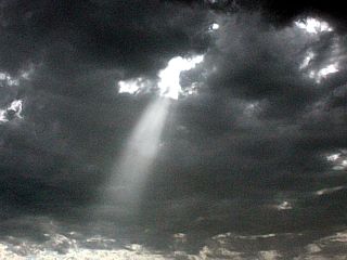
Crepescular rays shining through a weaking LP storm trying to go up in an area of weak convergence to the south of Des Moines, Iowa on June 24, 2015. |
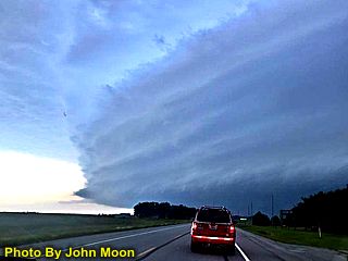
|
Here is a picture of my chase vehicle (photo by John Moon's girlfriend who was chasing with him that day) approaching the intense (formerly tornadic) HP storm and shelf cloud. |
|
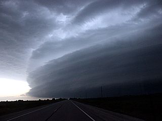
Another view of the impressive appearance of the shelf cloud associated with the wet RFD of the HP storm west of Winterset, Iowa. |
|
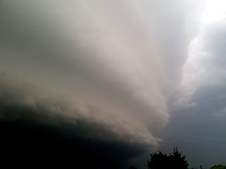
View of HP storm near Winterset, Iowa becoming outflow dominant and sending out a powerful gust front. This was late on June 24, 2015. |
|
Another intense supercell storm with strong rotation tries to produce a weak tornado near Greenfield, Iowa just before outflow undercuts the storm. |
|
Wrapping up the day (June 24) with a view east along Highway 36 at dusk towards a powerful MCS. The sky is extremely turbulent with outflow and an intensifying low-level jet. |
|
Here is a view of a supercell storm looming over the horizon and distant Chicago (IL) skyline on July 17, 2015. |
|
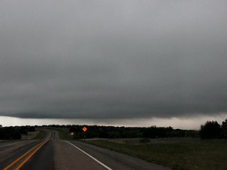
Towering cumulus along a NW to SE oriented outflow boundary (looking west on I-90 west of Rockford, IL). This was the start of strong and severe storms that will eventually produce severe weather in the area, including a weak tornado in McHenry County, IL. July 18, 2015. |
|
View to the east near Highway 14 approaching McHenry County, IL with explosively developing supercell storm looking to the east. This was part of a storm cluster, and will eventually produce a weak tornado on July 18, 2015. |
|
Intensifying rotating updraft base of supercell storm near Harvard, IL on July 18, 2015. |
|
Intense RFD clear slot developing with the classic to HP supercell storm east of Harvard, IL on July 18, 2015. |
|
View of developing weak tornado over rural areas of McHenry County, IL east of Harvard, IL on July 18, 2015. |
|
Weak tornado (to the far left in the photo) forms and does damage to trees and some farm buildings over McHenry County, IL and ENE towards the IL / WI border before weakening as the storm merged with other storms in the cluster of thunderstorms. July 18, 2015. |
|
Weakening storm becomes outflow dominant with a well developed shelf cloud and gust front as it evolves to a cluster of severe thunderstorms north of Woodstock, IL on July 18, 2015. |
|
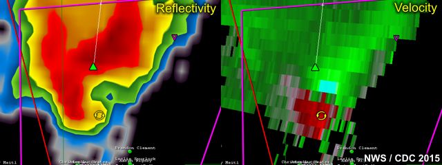
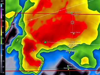
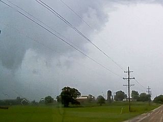
Tornadic supercell developing from 40 miles away over Grundy County, IL on August 18, 2015. |
|
Radar images (main image is reflectivity and upper-left inset is the velocity) of the northern cell (of two supercell storms). The northern one was the one affecting Grundy County / Mazon. Aug 18, 2015 at about 6 PM CDT. |
|
Rotating wall cloud near Mazon (Grundy County), IL on August 18, 2015. |
|
Funnel reaching the ground as a tornado with striking supercell structure looking NW from Highway 17 near Mazon, IL. August 18, 2015 during the evening (6:05 PM CDT). |
|
Close up of brief weak tornado west of Mazon, IL on August 18, 2015. |
|
Lightning as storm passes over the southern parts of Chicago on Aug 18, 2015. Still tornado warned. |
|
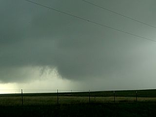
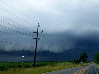
Approaching a highly sheared HP supercell (the view is towards the WSW) on November 11, 2015 in Monroe County to the southeast of Des Moines, Iowa. |
|
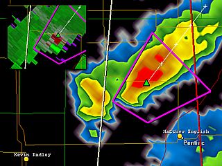
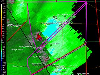
Here is a radar image (soppler velocity), showing a substantial couplet to my southwest (the GPS location is the white circle to the upper center part of the picture). This was a completely rain wrapped tornado in Monroe County (Iowa) on November 11, 2015. |
|
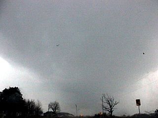
This is a view of the rotating base of the storm, looking northward, before being blasted with RFD winds. This was in Monroe County, IA on November 11, 2015 near Hiteman. |
|
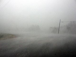
Strong winds (most likely wet RFD), buffeting the area near Hiteman, Iowa as a rain wrapped HP supercell tornado passes close to my location. |
HTML File "mwcl2015.htm" - Developed By Chris Collura
To Return To The HOME Page Of This Site Click The "INDEX.HTM" Link Here!