
This section is for storm chases done in the central / Midwestern United States during the year of 2014. This includes all storm chasing activities (including any major chase "expeditions") during the year of 2014 in the central USA (aka "Tornado Alley"). For 2014, all chases in the central USA will be logged in this section, with many of the chases being possible "spot" chases / major severe weather "setups" chased. Here you should find many pictures of lightning, tornadoes, hail, strong winds, along with many severe thunderstorm elements. Keep in mind that this chase log is scientific evidence and portrays my on-going storm chasing research. It has been placed on this page for easy reference and meteorological interests. Please do not plagiarize or copy this document to other sites for distribution.
Note - This page may take a while to load on some SLOWER connections! |
STORM CHASING - CENTRAL UNITED STATES - 2014 CHASE LOG
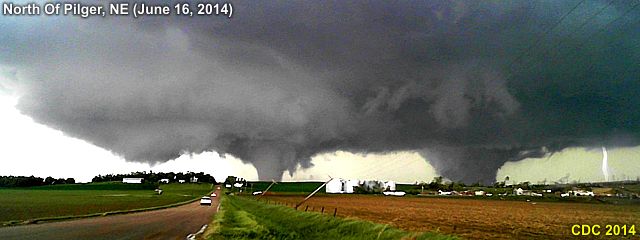
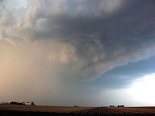
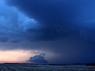
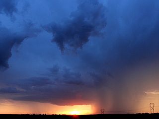
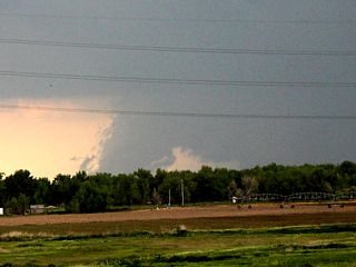
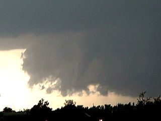
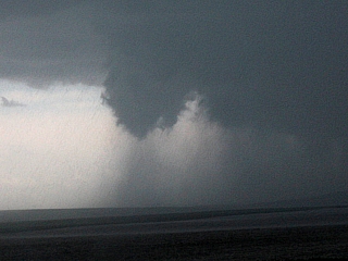
Above is an absolutely incredible view of the multiple violent tornadoes churning over the Nebraska countryside north of Pilger, Nebraska on the afternoon of June 16, 2014. At least two tornadoes are visible, each an EF-4 violent tornado (with the left one being possibly stronger) with yet a third tornado trying to form to the far left as lightning strikes to the right! These two tornadoes are actually interacting with one another since they are similar size in a phenominon called the "Fujiwhara Effect". They will eventually merge into a violent mile+ wide wedge tornado before occlusion and development of yet another tornado "family" to the east. The town of Pilger, Nebraska was completely destroyed by the tornado to the left, with at least 3 people killed about 15 minutes before this picture was taken (near Highway 275 looking to the north). Note the devastated farmstead in the foreground.
TABLE OF CONTENTS - CLICK TO GO TO PAGE
- ABOUT - ABOUT THIS CHASE LOG
- VIDEO - VIDEO SECTION FOR THIS CHASE LOG
- APRIL 3 - CHASE LOG FOR APRIL 3, 2014
- APRIL 12 - CHASE LOG FOR APRIL 12, 2014
- APRIL 25-28 - CHASE LOG FOR APRIL 25-28, 2014
- MAY 8 - CHASE LOG FOR MAY 8, 2014
- MAY 18-23 - CHASE LOG FOR MAY 18-23, 2014
- JUNE 2-4 - CHASE LOG FOR JUNE 2-4, 2014
- JUNE 13-17 - CHASE LOG FOR JUNE 13-17, 2014
- JULY 12 - CHASE LOG FOR JULY 12, 2014
- OTHER - OTHER CHASES IN 2014 IN THE MIDWEST
- END - JUMP TO END OF PAGE
ABOUT THIS CHASE LOG FOR THE MIDWEST
This is a chase log for any chases during 2014 in the Midwest and Central United States that were conducted as "spot" chases as well as any dedicated chase trip. Each chase section within this area will have its own details and such for that particular chase. This area was set up in the spring of 2014 and is for any chase that was conducted in the US Plains and Midwest. Equipment use in such chases range from cell phone to HAM radio communications, digital / still cameras, video (SD) and high-definition (HD) camcorders, and data logging / GPS via laptop computer. Storm chasing involved driving in harsh conditions and / or for long periods of time.
All chases and observations are in chronological order and a chase number is assigned to each entry. Please bear in mind that all observations adhere to modern storm analysis standards and do not include all storms that occurred in a given area for a particular chase period.
Any kind of storm such as a thunderstorm, tornado, waterspout, tropical cyclone, and extratropical storm can be chased or observed. I have tried to keep this log of any storms that I have observed as accurate as possible, while using terms and expressions to abide by those used by most meteorologists and storm spotters today.
Storm chasing and observation can be extremely dangerous and may result in serious injury or death. I have received intermediate and advanced training for storm spotting in 1996. I strongly urge anyone who is to try their hand at storm spotting to get training before doing so. You must also have a good understanding of meteorology and storm dynamics. "If you don't know what you're doing, Don't do it!" Contact your local National Weather Service office for information on storm spotting and about training to become a Skywarn storm Spotter.
CHOOSE A VIDEO CLIP BELOW - LINKS TO YOUTUBE
 Nebraska EF-4 Tornado "Family" On June 16, 2014
CHASE MAP FOR APRIL 3, 2014
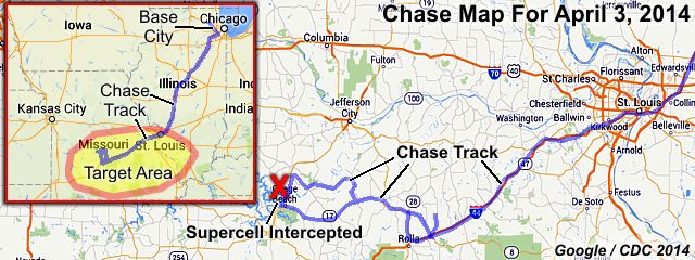
The chase map shown here is for the special "spot chase" trip for April 3, 2014 in the Central USA (mainly Missouri). The chase originated and terminated from a "base" near the Chicago area as I was working up there at the time (no flights or car rental involved). The red box is the chase / target area in the box inset to the lower-left. On the main part of the map, the blue lines denote the overall chase track, and red "X"'s denote where a storm intercept was done. The chase "target areas" that were considered during forecasting are denoted by the yellow colored areas.
CHASE TRIP CHRONOLOGY FOR APRIL 3, 2014
This chase trip was a single-day spot chase done from my "base" location at the time in the Chicago area (northwest of O'Hare airport) to the target areas (mainly in central Missouri), and a return late night that same day after chasing was completed. Upon waking up on April 3, I forecasted and found a good primary target to be pretty much near and along the I-44 corridor extending southwest of Saint Louis, Missouri and into and near Springfield. The SPC (Storm Prediction Center) had this same general area in an enhanced risk (moderate risk) with the tornado probabilities as high as 15% (hatched for significant), hail at 45% (also hatched), and a 45% damaging wind potential. The plan of the day was to get to the target area by about 3-4 PM, anticipating morning / early afternoon convection in place to clear out, with the more robust severe storms occurring later in the day.
I pretty much left my "base" (hotel in Hoffman Estates, IL) after packing up my vehicle (2009 Ford Escape) and headed out of the Chicago area via I-90, I-290 / I-294, and finally I-55 south towards Springfield, IL. I stopped in Springfield for fuel and to replace a failed inverter at around noon. A quick look at data revealed a messy area of strong and severe thunderstorms near Saint Louis, but the target area and forecast changed little. I continued south and southwest on I-55, then across the Mississippi River, through Saint Louis (into Missouri), and continued SW on I-44 towards Springfield. By about 3 PM I broke out of the on-going and weakening convection and entered the warm sector near Cuba and into Rolla on I-44. Temperatures changed from light rain and temperatures in the low 40's to start, giving way to sunny (hazy) conditions with temperatures in the lower 70's. The track then went out of Rolla, MO along Highway 63, and west along Highway 42 towards Osage Beach, Missouri. This is where the main storm of the day, an HP supercell, was intercepted.
The chasing continued in an area of storms from near Osage Beach, MO from near Highway 54, then south and eastward along Highways 52 and back on 42 towards Saint James, MO by evening. I also stopped for fuel just before intercepting the storm near Osage Beach. Chasing was done by about 7:30 PM CDT, so I continued back to the NE along Interstate 44 towards Saint Louis, then back across the river to I-55 into Illinois and back towards the Chicago area. I stopped for Fuel between Springfield and Normal, IL, then continued north and east along I-55 to I-290 / I-294, then I-90, returning to my hotel in Hoffman Estates by about 2 AM on April 4, 2014. Total mileage on the vehicle was 1011.6 miles.
APRIL 3 CHASE MAIN PARTICIPANTS
| CHASER NAME | HOME / BASE CITY | CALLSIGN | CHASE DATES | OCCUPATION |
| CHRIS COLLURA | CHICAGO, IL | KG4PJN | 4-3 | IT CONSULTANT |
STORM REPORTS FOR APRIL 3, 2014
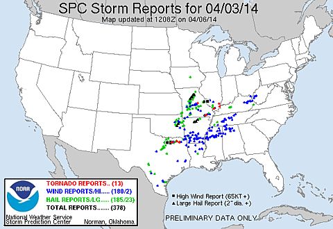
This is the storm reports from the SPC (Storm Prediction Center) for April 3, 2014. Red dots indicate that 13 confirmed tornadoes occurred. Green and blue dots indicate 185 reports of severe hail (1" or larger) and 180 reports of wind (at least 58 MPH), respectively during this period. Any reports of hail more than 2" in size (23 reports) and wind over 65 knots (74 MPH, with 2 reports) are denoted on the map by black triangles and black squares, respectively. The tornado and large hail reports in Missouri was from the HP supercell that I was on in Osage Beach and points northeast of there.
FORECASTING AND TARGET AREA - APRIL 3
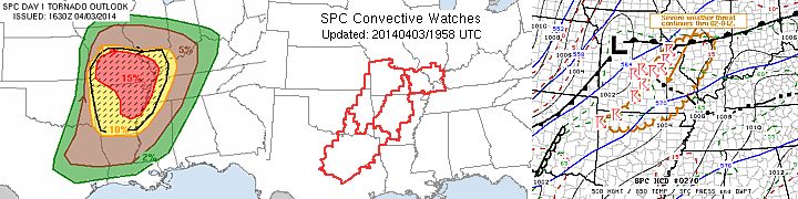
Above is a set of images from the Storm Prediction Center (SPC). The left graphic is the tornado probability for the 1630z outlook issued on April 3, showing a rather threatening 15 percent (hatched for the possibility of strong tornadoes) covering a large portion of Missouri and Arkansas. This turned out to be a bit over forecasted. The middle image are the convective watch boxes in place (4 tornado watches at the same time) issued during the afternoon of April 3. To the right, one of several Mesoscale Discussions (MCD 270) showing the setup for the storms in Missouri. The target area was pretty much along the I-44 corridor from SW of St Louis and NE of Springfield.
STORM RADAR / SATELLITE IMAGERY - APRIL 3
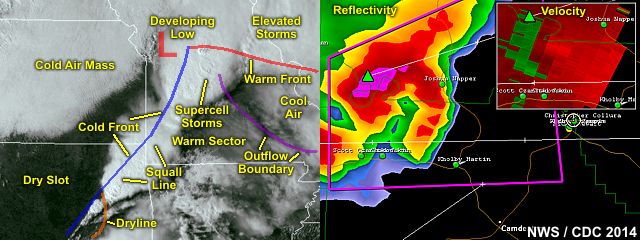
In the annotated images above, the visible satellite at about 21 to 22z on April 3 is shown, with the overlay of important synoptic features analyzed on forecasts. A Pacific cold front (N of a dryline segment) is moving in from the west, and interacting with both and outflow boundary (from earlier storms) and a warm front. The outflow from the earlier storms would eventually be a moderating factor in storm severity. A break in the clouds between the front and outflow allowed some heating to take place, and supercells to form ahead of the low pressure system before cold air undercut them late in the period. To the right is the base reflectivity (and velocity inset) of the HP supercell storm that was intercepted near Osage Beach, Missouri at roughly 5:30 PM CDT. This was about the time a possible rain wrapped tornado was going on pretty much right over the Lake of the Ozarks.
DETAILED CHASE LOG FOR APRIL 3, 2014
1). April 3, 5:30 PM - Observation and interception of a very severe (and possible tornadic) thunderstorm near Osage Beach, Missouri from along Highway 54 in Camden / Miller Counties and points east along Highway 52 to southwest of Osage County counties. The storm was a high precipitation supercell thunderstorm, which may have had a rain wrapped tornado at one point (while it was near or over the Lake of the Ozarks). The storm had a striking visual appearance, with striations on its mid level updraft. A powerful gust front developed as this storm became undercut by outflow later in its life cycle. The storm was penetrated (core encountered) as it was becoming o9utflow dominant. Frequent lightning, winds gusting near 70 MPH, torrential rains, and hail to dime size (1/2") was encountered with this storm. The possible tornado was radar indicated (warned storm) but not observed. Damage observed was some trees down and some roof debris littering a wooded area near highway 42 southeast of Eldon. The storm also caused minor flash flooding. Conditions causing the storm were surface heating, an upper trough, warm front, and an advancing dryline / Pacific front ahead of a surface low. Documentation was digital video, digital still photos, and audio. A 2009 Ford Escape was used to chase the storms. A tornado watch was also in effect for the area, valid until 7 PM CDT.
This concludes the chase log for the central US Plains and Midwest (tornado alley / Missouri) chase trip for April 3, 2014. The summary includes a total of 1 severe thunderstorm. The main chase vehicle conducting this chase was a 2009 Ford Escape. This information was prepared exclusively for the National Weather service and the team of Skywarn storm spotters.
GALLERY FOR APRIL 3, 2014
|
Interesting cloud formations and mammatus associated with severe thunderstorms near St Louis, MO on April 3, 2014. |
|
View of severe (tornado warned) HP supercell storm near Osage Beach, Missouri on April 3, 2014. |
|
Long beavers tail into wall cloud on tornado warned HP supercell storm near Osage Beach, Missouri on April 3, 2014. |
|
Gust front (shelf cloud) on tornado warned HP supercell storm as it becomes outflow dominant near Osage Beach, Missouri on April 3, 2014. |
|
Torrential rains and winds gusting near 70 MPH in the core of an HP supercell storm near Osage Beach, Missouri on April 3, 2014. |
|
Tree down along Highway 52 after the passage of an HP supercell storm near Osage Beach, Missouri on April 3, 2014. |
|
RFD clear area and wall cloud / funnel in SE Osage County, Missouri later in the day on April 3, 2014. |
CHASE MAP FOR APRIL 12, 2014
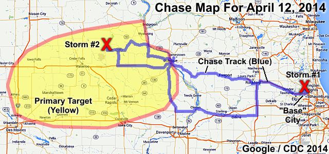
The chase map shown here is for another "spot chase" trip for April 12, 2014 in the Central USA (Illinois and Iowa). The chase also originated and terminated from a "base" near the Chicago area as I was working up there at the time (no flights or car rental involved). On the map, the blue lines denote the overall chase track, and red "X"'s denote where a storm intercept was done. The chase "target areas" that were considered during forecasting are denoted by the yellow colored areas. Note that one of the intercepts was very close to my "base" in the NW Chicago suburbs!
CHASE TRIP CHRONOLOGY FOR APRIL 12, 2014
This chase trip was a single-day spot chase done from my "base" location at the time in the Chicago area (northwest of O'Hare airport) to the target areas (mainly in central to NE Iowa), and a return late night that same day after chasing was completed. Early on April 12, I forecasted and found a good primary target to be in central to NE Iowa, anywhere NE of Des Moines and points east and northward towards the upper Mississippi River valley where IA, WI, and IL meet. To a surprise, a very severe storm developed just north of my "base" city in the NW Chicago suburbs, and became the first storm intercepted that day, before beginning the trip to Iowa.
The SPC (Storm Prediction Center) had the area in Iowa and Illinois in a slight risk, with only a 2% tornado prbability and a 15% wind probability. However, the hail probability was set at a rather high 30% and was hatched (significant threat of 2" hail). The plan of the day, after being "side" tracked by the NW suburbs storm during the late morning, was to head west towards Iowa, initially on Interstate 90 out of Hoffman Estates and towards Rockford. Upon leaving in the early afternoon, I ran into a rather significant construction delay on I-90 (toll road) east of Rockford - So chasers - Beware of that!
Once in Rockford, I dropped south on Interstate 39 to Highway 30, and headed west across the MI River into Iowa near Clinton. After looking at data on the fly, I realized the place to be was farther northwest (near the frontal boundary), with some storms firing near the corners of IA / WI / IL. I decided to head north on Highway 61 to near Dubuque, then NW along Highway 52. The stationary frontal zone was encountered there, and an impressive temperature drop from 83 deg F to about 60 was noted south of Guttenberg. With the storms becoming elevated over the cool air, I decided to make my way back SW and picked up SR 13 then Highway 3 west towards a promising storm near Waverly, IA.
I was pretty much done with the Waverly storm by about 8 PM CDT, then pretty much headed back east on Highway 3 to Highway 150 south, then east on Highway 20 all the way past Debuke (crossing the MI River there) and into Illinois to Rockford. I picked up Interstate 90 (toll) back to my "base" city (Hoffman Estates), arriving there about midnight. Total mileage on the vehicle was 581 miles.
APRIL 12 CHASE MAIN PARTICIPANTS
| CHASER NAME | HOME / BASE CITY | CALLSIGN | CHASE DATES | OCCUPATION |
| CHRIS COLLURA | CHICAGO, IL | KG4PJN | 4-12 | IT CONSULTANT |
FORECASTING AND TARGET AREA - APRIL 12
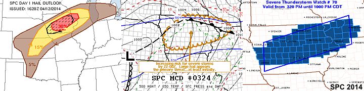
Above is a set of images from the Storm Prediction Center (SPC). The left graphic is the hail probability for the 1630z outlook issued on April 12, showing 15 percent (hatched for the possibility of very large hail) covering a large portion of Iowa. The middle and right images shows mesoscale discussion (MCD) #324 and subsequent severe thunderstorm watch box #70 valid until 10 PM CDT, respectively.
STORM RADAR / SATELLITE IMAGERY - APRIL 12
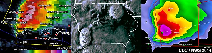
In the images above, there is two radar (base reflectivity) images, with the intense core of the supercell storm over NW Cook County, Illinois during the late morning, and to the right, the base reflectivity image of the Waverly supercell storm in Iowa later that evening on April 12. Note the large "hail spike" to the lower left side of the image. In the center image, the visible satellite shows the supercell storms welling up over NE Iowa, as well as some multi-cell storms far to the southwest.
DETAILED CHASE LOG FOR APRIL 12, 2014
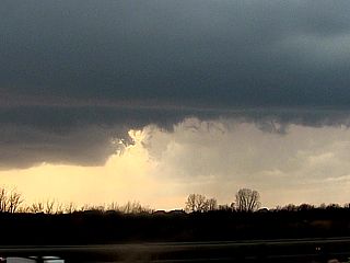
1). April 12, 11:30 AM - Observation and penetration of a very severe thunderstorm moving across northwestern Cook County, IL from near Barrington Road and southeastward along Highway 14 to near Paletine. The storm was a supercell storm that developed on the southern end ("tail end Charley" storm) of a line / cluster of strong and severe storms. The storm had a distinct RFD cut and rotation (with a rotating wall cloud and small funnel) on its SW side. A portion of the intense core was encountered near Barrinton Road and Highway 13, with hail up to 2" (hen egg size) falling. Frequent lightning, moderate rain, and 40 MPH winds were also noted with this storm. Damage was mainly because of the very large hail, with broken windows / dents being common. The storm was caused by a stationary front, convergence line (along and near the low level jet), and an upper trough. A 2009 Ford Escape was used to chase the storms. Documentation was digital stills, audio, and HD video.
2). April 12, 7:00 PM - Interception and observation of of a very severe thunderstorm northeast of Waverly, Iowa in Bremer county fron near Highways 3 and 63. The storm was an elevated (north of a surface frontal boundary) supercell storm. The main focus on intercepting these storms was for observation of large hail. Upon reaching the path the storm passed over (the core was not penetrated), hail up to 2" was observed laying on the ground with hail fog. The storm had an impressive hail core, and wet RFD (with green "glow") when viewed from its SW side. The storm affected rural country and no damage was observed. Winds near 35 MPH, rain, and frequent lightning was also observed with this storm. The storm was caused by a stationary front, surface heating, low-level convergence, and an upper trough. A 2009 Ford Escape was used to chase the storms. Documentation was digital stills, audio, and HD video. A severe thunderstorm watch was also in effect for the area, valid until 10 PM CDT.
This concludes the chase log for the central US Plains and Midwest (tornado alley / Illinois and Iowa) chase trip for April 12, 2014. The summary includes a total of 2 severe thunderstorms. The main chase vehicle conducting this chase was a 2009 Ford Escape. This information was prepared exclusively for the National Weather service and the team of Skywarn storm spotters.
GALLERY FOR APRIL 12, 2014
|
Updraft region (note RFD) of supercell storm (tail end of line) crossing north of I-90 in the NW Chicago suburbs on April 12, 2014. |
|
Golfball sized hail falls from a "tail-end' supercell storm near Barrington, IL (April 12, 2014) in the NW Chicago suburbs. |
|
Here is a picture of myself in the chase vehicle (my 2009 Ford Escape) headed west on Highway 3 towards a storm near Waverly, IA on Apr 12. |

|
Elevated supercell (just north of stationary front) near Waverly, IA on April 12, 2014. Intense hail core is just right of the road. |
|
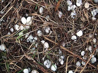
Golfball sized hail laying in the grass behind the supercell in IA near Waverly N of Highway 3 on Apr 12. |
|
View of hail core (left) and updraft (right) and developing RFD (center) assicaiated with the supercell storm NE of Waverly, Iowa on April 12, 2014. |
|
Interesting 'scud bomb' under the mesocyclone north of Highway 3 and east of Waverly, IA on April 12. |
CHASE MAP FOR APRIL 25-28, 2014
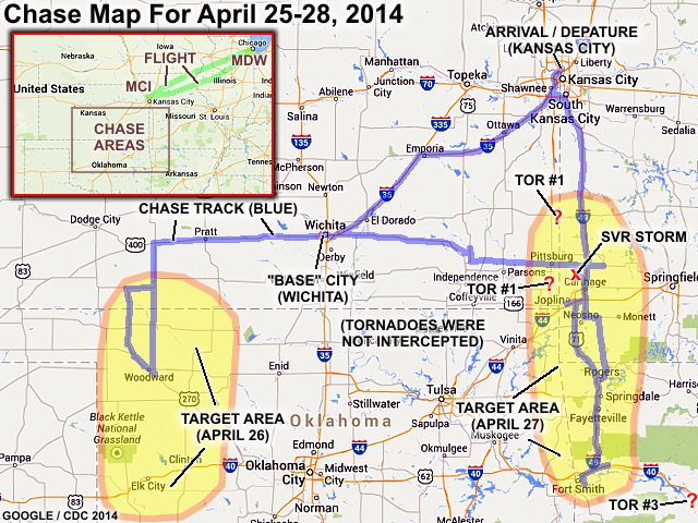
The chase map shown here is for a mini chase trip to the Central USA from April 25 to April 28, 2014. The chase involved a flight from (and returning to) the Chicago area (Midway airport) to the arrival city of Kansas City, Missouri (flying in on April 25 and returning to Chicago on the 28th, these days being travel days. Upon arriving in Kansas City, and picking up the rental car, I headed to Wichita, Kansas, which served to be my main "base" city for the two chase days. The chase days were April 26 (in Kansas and Oklahoma) and the 27th from eastern Kansas into Missouri, then down to Arkansas. This chase trip turned out be very unsuccessful, with the first day being a total cap "bust" (storms suppressed by dry capping layer aloft) and the next day failing due to bad terrain (trees and hills) and bad positioning / abandoning my primary target. After chasing, I returned to Kansas City and flew back to Chicago on Monday morning, April 28.
CHASE TRIP CHRONOLOGY FOR APRIL 25-28, 2014
This chase trip began on April 25, 2014 with a flight out of the Chicago area (I am working up here on a long-term computer project) to Kansas City, Missouri. I picked up the rental car there during the late evening, and headed down I-435 to I-35, then down the Kansas Turnpike into Wichita just after midnight. Upon waking up early on April 26, I prepared the rental vehicle (electronics and gear), took breakfast, and forecasted. The day appeared to be a "day before the day" type of event possible, with a vigorous upper level storm system forecasted to move in from the California area aloft. The down sides and what made the chase so tentative was the lack of moisture and capping (a warm dry layer aloft preceding the upper support).
The plan of the day was to head to the area from SW Kansas into Western Oklahoma. The storm prediction center also had this area in a slight-risk outlook, with a 5% tornado, 15% wind, and 30% hail probability (the hail was hatched / significant). The tornado outlook area extended from SW OK to SW Kansas and east of a TX / OK line. I left Wichita and headed west on Highway 400 / 54, through Pratt, and to Greensburg for fuel. Upon looking at more data, it appeared apparent that the warm layer aloft (700 mb 10 deg C) would be a problem, coupled with limited moisture return (55 to 60 deg dewpoints at best). SPC also reflected on this by dropping the tornado probability to 2% and removing the significant threats (hatching) on their hail outlooks.
After leaving Greesburg, I headed south on 183 and into Oklahoma. By mid-late afternoon (4 PM or so), I stopped in Woodward to assess the situation on where storms would fire. The atmosphere remained stable and capped, despite a prominent dryline extending from north to south through Dodge City, Kansas southward into western Texas. The only storms that did develop were very far south in Texas (and were brief high based / marginally severe storms) in a region of weaker shear (but a weakening in the cap / CIN "hole"). By early evening, the atmosphere remained capped, and my forehead even had a little sunburn. This was now time to realize hundreds of storm chasers across the plains were experiencing an epic "cap bust"!
I headed back north out of Woodward via Highway 34 back into Kansas to meet up with the eastward jog of 183, then 183 north to Greensburg for fuel and food stop. Some cumulus was noted to the west along the dryline, but apparently became supressed by the strong inversion aloft. In fact, no watches were even issued for these target areas. Anticipating a better chase day to the east towards the Missouri / Kansas border and southward on April 27, I left Greenburg and headed back east to Wichita for the night. April 27 was what seemed to be a good shot at seeing tornadoes, with a moderate risk outlooked by SPC extending from the southeast of Kansas City, across SW Missouri, and into the nearly un-chaseable forests / mountains of western and central Arkansas.
Upon waking up, I forecasted and headed east out of Wichita along Highway 400. I had a bad feeling about chase "success" seeing morning convection in place over much of southern Kansas, with a severe thunderstorm watch also in effect. The moderate risk had a tornado probability of 15% (hatched for significant), with a wind probability of 30%, and hail at 45% (also hatched). Based on my forecast (you'll find out later why your FIRST target is usually right), the plan of the day was to focus on the area along the KS and MO border, and east of there, from about 100 miles south of Kansas City and into NW Arkansas. I headed east on Highway 400, through the Flint Hills to Highway 39 and through Chanute.
Continuing east, and still behind the weakening MCS in rain and lightning, road construction along Highway 39 made for a pesky detour down to highways 59 and 47 through Girard and eventually into Missouri towards Lamar on Highway 160 for fuel. The edge of the rain-cooled air was also passed, with a distinct boundary there, and the cool pool left by the earlier storms started to weaken. This area was watched for some time, with a small supercell storm firing northwest of Jasper and west of Highway 71 (about 2:30 PM). This area continued to be affected by the cool air in place, so I left south along Highway 71 and west on I-44 to near Joplin and stopped east of there to look at data. It appeared it would be good to try going south.
By now, SPC was trending the dynamics farther south into Arkansas, along an advancing warm front, and now had the southern 2/3 of Arkansas outlooked in a high risk, with a 30% hatched tornado, 30% wind, and 45% hatched hail (hatched being significant). A dryline was advancing towards the western Arkansas border and warm sector advancing northward east of it. So what did I do? You guessed it! One of the biggest storm chaser mistakes ... LEFT my primary "target" and got "suckered" south (these being veteran chaser terms)! I headed down I-49 / 540 to see if I can make Fort Smith for some developing supercell storms moving into that area from SE Oklahoma. I made Fort Smith by about 6:30 PM and stopped near I-540 and I-44 junction to look at data.
The two supercells were now moving to the SW of Fort Smith, one being a weakening left split, and the southern one evolving to a multicell cluster. A cluster of suupercells was also noted along the warm-front / low-level jet axis to the east, over the Quachita National Forest, and moving NE towards I-40 west of Little Rock. I considered a chase to the east, but it would be 100 miles before I got to the storms - Which one of which was to become the deadly Mayflower, Arkansas tornado. I opted to go down I-540 east of Fort Smith, then got frustrated by more major construction. To add "salt in a wound" - I looked down at GRLevel (Gibson Ridge) radar / GPS only to see two "confirmed and extremely large tornadoes" well to my north - IN my ORIGINAL target area!
This was the point I called OFF the chase. I turned back around via an exit off I-540, and headed back north towards I-40 out of Fort Smith, still avoiding heading east towards Little Rock (I had to be back to Kansas City anyway for early flight back the next day), and back-tracked back up I-540 in a highly frustrated and agitated fashion. You NEVER leave your primary target (KS / MO border from 50 miles south of Kansas City to Arkansas border) - Lesson learned (ouch)! I continued heading back north along I-540 and diverting east and north on some country roads (highways 340 / E to 76). I anticipated the tail-end of the line (formerly the tornado producing supercells near Galena and Fort Scott, Kansas and into Missouri) to back build.
Upon reaching the area south of I-44 near Granby, a brief low-topped supercell storm tried to go up, but cooler (worked-over) air killed it after sunset, and the hazy cool dry air pushed in from the west (Pacific front / dryline). I stopped near the intersection of Highways 59 and 60 to pack the gear from the vehicle, then north towards Highways 71 and I-49 all the way to I-435 in Kansas City, spending the night in Lenexa, Kansas. Upon waking up the next day on April 28, I checked out of the hotel and headed up I-435 to Kansas City International airport. I returned the rental vehicle, a 2014 Hundai Accent, and returned to Chicago on a mornig flight back. Total mileage on the rental vehicle was 1,483 miles.
APRIL 25-28 CHASE MAIN PARTICIPANTS
| CHASER NAME | HOME / BASE CITY | CALLSIGN | CHASE DATES | OCCUPATION |
| CHRIS COLLURA | CHICAGO, IL | KG4PJN | 4-25 TO 4-28 | IT CONSULTANT |
FORECASTING AND TARGET AREA - APRIL 26
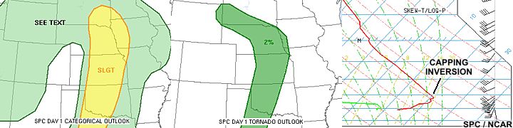
In the diagrams above, the SPC outlook shows the areas outlooked in a slight risk on April 26, and the middle image shows the 2% tornado probability (downgraded from a 5%). To the right image is a sounding during the afternoon showing a distinct "nose" on the temperature skew-T plot - A pretty massive capping inversion with a convective temperature well over 100 deg F. Obviously the prominent inversion in right image "promises" anyone storm chasing in Oklahoma or Kansas thet they will NOT be seeing any storms today.
FORECASTING AND TARGET AREA - APRIL 27
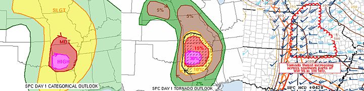
In the image above, the high-risk and moderate risk areas are shown for the afternoon of April 27, along with the tornado probabilities (30% and hatched) at the same time. To the right image is the complicated mesoscale discussion showing the position of the boundaries and fronts ahead of the low and dryline near Arkansas and Missouri. At least 4 tornado watch boxes were in effect simulatneously during the afternoon of April 27, with one PDS (Particularly Dangerous Situation) watch box over the southern 2/3 of Arkansas.
STORM RADAR / SATELLITE IMAGERY - APRIL 27
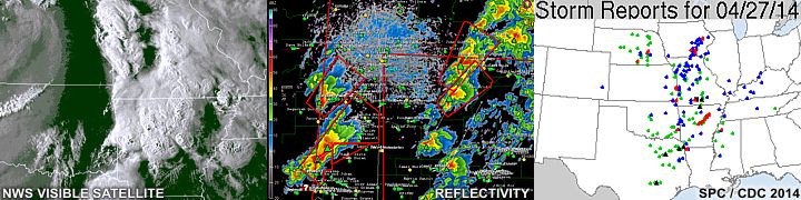
In the image above, we see the visible satellite during the evening of April 27, with storms erupting over Arkansas and Missouri to the left. In the middle is a radar reflectivity image showing supercells developing over Arkansas, with one cluster containing the soon-to-be deadly storm to affect areas NW of Little Rock. To the right is the storm reports (totalling 306) for April 27 as per the storm prediction center. A total of 38 tornadoes were reported, along with 130 wind reports (2 significant), and 138 hail reports (8 of which were significant). April 28 and 29, although these days were not chased, were to be even worse.
DETAILED CHASE LOG FOR APRIL 25-28, 2014
1). April 27, 2:30 PM - Interception and observation of a severe thunderstorm to the northwest of Jasper, Missouri in Jasper County from west of Highway 71 and near Highway 160. The storm was a supercell storm (classic supercell) and a rotating wall cloud and RFD clear area was observed with this storm. The core of this storm was not penetrated, and the storm quickly weakened as it became elevated over a cool pool of air north of an outflow boundary afterwards. The storm was caused by a low pressure area, surface heating, upper trough, dryline, and outflow boundary interactions. Documentation was HD video and stills. A 2014 Hundai Accent was used to chase the storms. A tornado watch was also in effect for the area until 9 PM CDT.
This concludes the chase log for the central US Plains and Midwest chase trip for April 25 to April 28, 2014. The summary includes a total of 1 severe thunderstorm. The main chase vehicle conducting this chase was a 2014 Hundai Accent. This information was prepared exclusively for the National Weather service and the team of Skywarn storm spotters.
GALLERY FOR APRIL 25, 2014
|
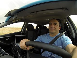
Once in Kansas City, it was time to prepare the car and drive to Wichita, Kansas for the night. Here is a "selfie" picture of myself driving the rental vehicle, a 2014 Hundai Accent. |
GALLERY FOR APRIL 26, 2014
|
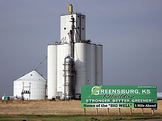
Here is a view of some grain bins and equipment near the intersection of Highway 183 and Highway 54 just west of Greensburg, Kansas during a "blue sky cap bust" on April 26. This town was destroyed by a poerful EF-5 tornado in early May 2007. |
|
The dryline becomes visible looking west from near Greensburg, KS towards Dodge City with a weak line of cumulus. One turkey tower here, bubbles up into the dry and warm layer aloft, before the capping inversion destroys it. |
GALLERY FOR APRIL 27, 2014
|
This is a wall cloud and weak RFD clear cut (note the interesting tail cloud) from a small supercell storm in Jasper County, Missouri on April 27. The storm developed quickly but then became elevated atop a cooler outflow air mass from earlier storms and weakened. |
|
This is later on on April 27 looking north from near Bentonville, Arkansas into southwestern Missouri. This is one of the "tail end" storms associated with a line of tornadic supercells as I was trying to back track to catch up with them after making the mistake of abandoing my target area, which was where the original supercell on the picture above formed. |
|
This is an interesting mesocyclone that developed on the tail end storm just north of the Missouri / Arkansas border and to the east of I-29 / 540. This was a low topped storm that struggled but was killed by more cool outflow air from the north and west. |
GALLERY FOR APRIL 28, 2014
|
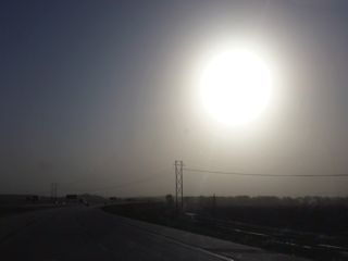
The storm system the produced the severe weather was a powerful lee cyclone by the morning of April 28. In the clear / dry slot of the storm, strong winds blew dust from the SW USA (Colorado and New Mexico) as far east as Illinois! In Kansas City, the sun takes on a tawny appearance from this dust in the low to mid levels. |
|
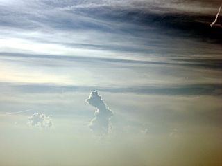
While in the air and returning to Chicago, and somewhere over eastern Iowa, the sky is clear and blue at 30,000 feet+ but the mid level dust is below us, making is look like as if we were flying over a desert area insrtead of the US Midwest. |
CHASE MAP FOR MAY 8, 2014
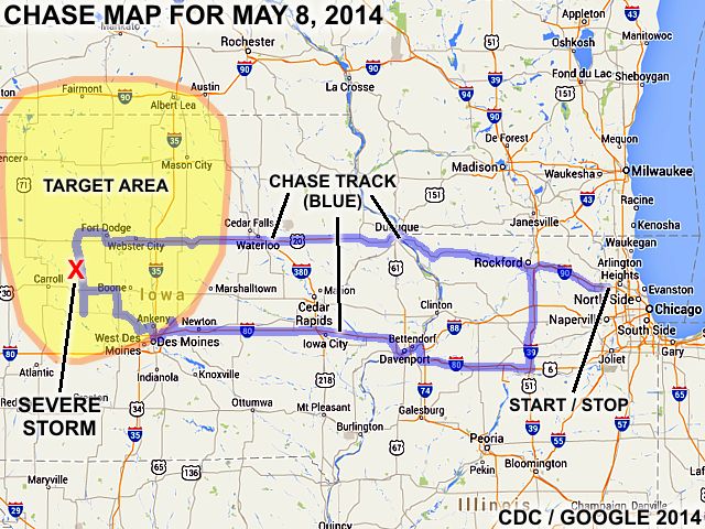
The chase map shown here is for the special "spot chase" trip for May 8, 2014 in the Central USA (mainly Iowa). The chase originated and terminated from a "base" near the Chicago area as I was working up there at the time (no flights or car rental involved). The blue lines denote the overall chase track, and any red "X"'s denotes where a storm intercept was done. The chase "target areas" that were considered during forecasting are denoted by the yellow colored areas.
CHASE TRIP CHRONOLOGY FOR MAY 8, 2014
This chase trip was a single-day spot chase done from my "base" location at the time in the Chicago area (northwest of O'Hare airport) to the target areas (mainly in central towards NW Iowa), and a return late night that same day / early the next day (1 AM or so) after chasing was completed. Upon waking up on May 8, I forecasted and found a good primary target to be pretty much from west-central Iowa (NW of Des Moines) and towards the north into SW and southern Minnesota just north of the IA / MN border. The SPC (Storm Prediction Center) had this area in a moderate risk with the tornado probabilities as high as 10% (hatched for significant), hail at 45% (also hatched), and a 15% damaging wind potential. The plan of the day was to work in the morning at my job here and leave early (about 10 AM) in order to get to the target area(s) by about 3-4 PM.
I left my office here in Hoffman Estates, IL in my vehicle (2009 Ford Escape) at around 10 AM and out of the Chicago area via I-90 westbound through Rockford, then Highway 20 passing into Dubuque, Iowa by about 12:30 PM. I continued west on Highway 20 through Waterloo and eventually Passing I-35 and heading a bit north on Highway 169 to Ford Dodge, Iowa to stop for fuel, prepare the vehicle (hail grills), and look at more data. By this time (about 4 PM), the capping inversion was eroding rapidly and initiation of storms was evident in two main areas. One was to my SW near Audubon (dryline bulge) and another in the far more preferred area in SW Minnesota (near the warm front) near Windom and St James. The latter would be very difficult to reach in time, but produced a brief (and ONLY) tornado of the day. I focused on working a cluster of storms, some supercells, anywhere from Highway 4 and 30 from near Jefferson, and eventually working my way SE back towards Des Moines and I-80 by evening.
Chasing was pretty much wrapped up by evening (about 8 PM) on I-80 just east of Des Moines. A small supercell storm was observed there at dusk. The storms farther north in Minnesota never got organized like they were earlier, and any storm cells to the south in my area weakened after dark. The culprit was lack of low level forcing and weak winds despite very dynamic upper level support. I pretty much headed east on I-80 through Davenport and back into Illinois. I took I-39 north to Rockford, then back east on I-90 to Hoffman Estates (and my hotel) by about 1:30 AM (May 9). Total mileage on the vehicle was 881.1 miles.
MAY 8 CHASE MAIN PARTICIPANTS
| CHASER NAME | HOME / BASE CITY | CALLSIGN | CHASE DATES | OCCUPATION |
| CHRIS COLLURA | CHICAGO, IL | KG4PJN | 5-8 | IT CONSULTANT |
FORECASTING AND TARGET AREA - MAY 8
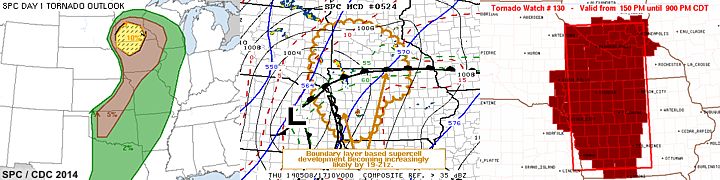
In the graphic above, the SPC (Storm Prediction Center) products are shown for the day on May 8. To the left is the tornado graphic showing a 10% (hatched for significant) area from NW Iowa and into southern Minnesota, which is part of a moderate-risk outlook that also included a 45% hail (hatched), and a 15% damaging wind potential. A large 5% probability for tornadoes extends as far as SW Oklahoma near the TX Panhandles area. In the middle is the SPC MCD (mesoscale discussion #524) that was issued for the target areas as well as subsequent tornado watch box #130 to the right, valid until 9 PM CDT. My plan was to play the west-central to NW Iowa target area, impinging on the southern portion of the 10% hatched tornado area, with south-central Minnesota a bit far considering time constraints (this was a "spot" chase, and I needed to be back in Chicago the next day).
STORM RADAR / SATELLITE IMAGERY / STORM REPORTS - MAY 8
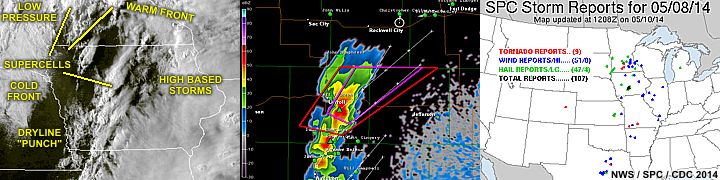
In the images above, from left to right, is the visible satellite (annotated to show key areas) as well as the radar imagery (base reflectivity out of DMX) in my region NW of Des Moines by late afternoon at roughly the same time. To the right are the SPC storm reports for this event (May 8). A total of 9 tornado reports, 51 wind, and 47 hail (with 4 significant, over 2") were logged. Not very much for such a setup (the tornadoes were relatively brief and weak, and confined mostly to a supercell in Minnesota). The annotated diagram to the left (visible satellite) shows the supercell storms firing in both "target" areas with a break in activity over NW Iowa.
DETAILED CHASE LOG FOR MAY 8, 2014
1). May 8, 6:00 PM - Observation and interception of a severe thunderstorm near Jefferson, Iowa and near Highways 4 and 30 in Greene County. The storm was a multicellular / supercell storm complex. A tornado warning was issued for the storm, and RFD winds (with an RFD clear slot) gusted over 60 MPH with heavy rain, lightning, and small hail near the storm core. No tornado was observed. Conditions causing the storm were surface heating, an upper trough, and advancing dryline / Pacific front ahead of a surface low. Documentation was digital still photos. A 2009 Ford Escape was used to chase the storms. A tornado watch was also in effect for the area, valid until 9 PM CDT.
This concludes the chase log for the central US Plains and Midwest (tornado alley / Iowa) chase trip for May 8, 2014. The summary includes a total of 1 severe thunderstorm. The main chase vehicle conducting this chase was a 2009 Ford Escape. This information was prepared exclusively for the National Weather service and the team of Skywarn storm spotters.
GALLERY FOR MAY 8, 2014
|
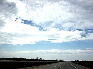
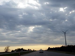
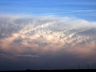
Headed west on Highway 20 and into central Iowa, the high clouds break with a distinct clearing and ACCAS (altocumulus castellanus) clouds as the lead impulse passes overhead and cap-eroding shortwave axis (and upper air support) approaches from the west. Convection should begin shortly after this wave passes, and the capping inversion is eroded (or overcome). Visually, these clouds were highly sheared and the upper layers rapidly overtaking the lower ones. |
|
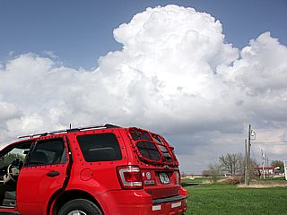
The cap is eroded and towering cumulus develops in a region of low level confluence by late afternoon not far from Fort Dodge, Iowa. I am stopped and putting the hail grills on my vehicles windows. |
|
Looking north from near Jefferson, Iowa, a small supercell storm (this storm was tornado warned for radar-indicated rotation) produces a horseshoe updraft and distinct RFD clear-slot. |
|
This is a view of the NW side of a cluster of severe storms to the northwest side of Des Moines, Iowa later in the day. This is the same storm that produced hail the size of baseballs (2.75" reported near Des Moines). The main updraft and hail shafts can be seen to the lower right. The view is to the SE. |
|
A small supercell storm and rain-free base (with hail and precipitation to its right) is illuminated by the setting sun NE of Des Moines, Iowa at dusk. The view is to the NW. |
CHASE MAP FOR MAY 18-23, 2014
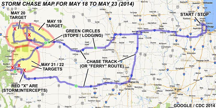
The chase map shown here is for my main chase trip (chasecation / expedition) to the Central USA from May 18 through May 23, 2014. The chase trip involved a drive from the Chicago area using my own chase vehicle and to the respective locations and targets in the central USA for the period, with a return to the Chicago area that was originally planned for June 1, 2014, but moved back to May 23 due to poor chase prospects (marginal and in far SW TX / NM after May 23). The blue line is the chase track as well as the "ferry" route (between the Chicago area and target areas chased). The red X's denote where a storm intercept was done. The green circles are stops (logging for some of the nights during the trip). The target areas are outlined with the yellow polygons, and May 21 and 22 were nearly identical.
CHASE TRIP CHRONOLOGY FOR MAY 18-23, 2014
May 18 was the travel and departure date marking the start of this chase trip. I left the Chicago area around noon and headed south to take I-80 west. I crossed the Mississippi river into Iowa, then through Des Moines, and reached Omaha, Nebraska by evening (8 PM or so). There were supercell storms in Nebraska, but they are in the far western parts of the state. Anticipating more supercell storms in the SW Nebraska Panhandle on Monday (5/19), I continued west on I-80 and spent the night in York, Nebraska, arriving there at about 10:30 PM CDT.
May 19 was the first chase day of this trip, and was a marginal chase day that turned out to be quite fun with some beautiful supercell storms intercepted in the western part of Nebraska near Scottsbluff and points southeastward. I forecasted and found the best place to be was from the SW Nebraska panhandle area and northward to near Scottsbluff. The SPC (Storm Prediction Center) also had this area initially in a very small slight-risk area, with 2% tornado, 5% wind, and 15% hatched (significant) hail probabilities. As the day progressed, this was downgraded to a see-text (but a bit "under" forecasted). I stuck with the target area, heading west out of York on I-80 to Ogallala, then northwest on Highway 26 to the area near Scottsbluff. I stopped at Chimney Rock where I saw Bill Hark, before continuing to chase developing storms near the Gering / Scottsbluff area. By later afternoon, storms finally became more established, with a beautiful LP supercell observed from near Harrisburg along Highway 71 and southeastwards via Highway 52 through Dix and to I-80 east to near Sidney and Chappell. I wrapped up the chase near Chappell, Nebraska by about 9:30 PM and headed east on I-80 to Big Springs for the night.
May 20 was another marginal chase day, with a slight-risk outlook for the higher terrains of western Nebraska, Wyoming, and Colorado. The plan of the day was to chase in an area of upslope and moisture convergence, expecting multicellular severe storms, with the possibility of supercells. The SPC had a slight-risk outlook with probabilities for 2% tornado, 15% wind, and 15% hail. I left Big Springs and headed west on I-80 all the way to Cheyenne, Wyoming, briefly meeting with other storm chasers Verne Carlson and a few others. After that, initiation was just starting farther north near Wheatland, WY. I headed north on I-25 out of Cheyenne towards Chugwater, then left I-25 east to near Slater on Highway 314. I picked up two supercell storms, following them east and northeast towards Hawk Springs, Wyoming via Highways 85 and 161. I crossed back into Nebraska and wound up ending the chase to the east of Scottsbluff, Nebraska. I continued east on Highway 26, then south on 385 to I-80. I headed east on I-80 and into Ogallala for the night. Ogallala was a good choice as the target for May 21 may be anywhere from NW Kansas to NE Colorado.
May 21 was to be the greatest chance at seeing tornadoes, and a trip to NE Colorado was part of the days plan. I forecasted and found the best area anywhere from north of Denver, Colorado and points eastward. The SPC had this area in a slight risk outlook, with a 10% tornado, 15% wind, and 30% (hatched) hail probabilities for an area bulls-eyed just north and east of Denver. I left Ogallalla, Nebraska and headed west on I-80 then I-76, reaching Brighton, Colorado by noon local time. This area seemed to be the place to be, and storms began initiating near Golden, Colorado / Denver to the SW. This storm was the main tornadic supercell of the day, and was tracked from near Denver International Airport and eastward along Bromley Lane to Highway 79 south (and along farm roads), eventually winding up heading east on Highway 36. The chase ended on Highway 71 north of Last Chance, Colorado. After I was done chasing, I headed back along Highway 36, taking a detour to the hail swath and flooding to the north of Byers, then resumed west on Highway 36 to I-70, and west into the city, and south on I-255 for the night in Aurora.
May 22 was a marginal chase day with an LP supercell observed right over Denver metro and a cluster of severe storms later on. I began the day with forecasting and preparing the vehicle. A slight-risk was in place extending from Wyoming all the way down to New Mexico. A 2% tornado, 15% wind, and 15% hail probability was forecasted by SPC with the 2% tornado to the NE of Denver and into NE Colorado. The plan of the day was to prepare the vehicle (clean up and oil change) and head just north of Denver off I-70 and I-25. An LP supercell developed over the city and lasted for about an hour. After that, I headed east on I-70 to near Byers, Colorado in Adams County and near CR 181. This is where another round of severe thunderstorms was observed. After wrapping up chasing, and anticipating poor / marginal chase prospects starting the next day and lasting for over a week, I decided to head east on I-70 back into Kansas and into Hays, Kansas for the night. I was not sure if I would consider the forecasted slight-risk in TX / OK two days later worth chasing or not (if not, I would head back to Chicago and return to Tornado Alley later).
The decision to cut the chase trip short and end it on May 23 was made, owed to some marginal chase prospects over a day's drive away in far SW Texas and New Mexico for the next couple of days followed by a relatively long quiet period (possibly a week with very marginal setups at best). I left Hays at about 9:30 AM or so and headed east on I-70, reaching Kansas City, MO by noon. I headed up I-35 out of KC to Des Moines, Iowa to I-80 east via I-235 around the capitol city. I headed east on I-80 through Davenport and across the Mississippi River into Illinois, then north on I-55 and I-355 to I-90, heading west back to Hoffman Estates. This concludes this "truncated" chase trip, with a total mileage on the vehicle of 3377.6 miles.
MAY 18-23 CHASE MAIN PARTICIPANTS
| CHASER NAME | HOME / BASE CITY | CALLSIGN | CHASE DATES | OCCUPATION |
| CHRIS COLLURA | CHICAGO, IL | KG4PJN | 5-18 TO 5-23 | IT CONSULTANT |
DETAILED CHASE LOG FOR MAY 18-23, 2014
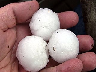
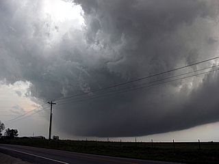
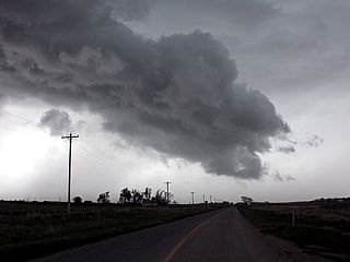
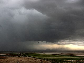
1). May 19, 7:30 PM - Observation and indirect penetration of a very severe thunderstorm from near Harrisburg in Banner County, Nebraska and Highway 71, and points east and southeast through Dix on Highway 59 and eastward along Interstate 80 towards Chappell in Deuel County. The storm was a high based but intense LP supercell storm. The storm had a very striking visual appearance, including a high based wall cloud, striations, RFD clear-slot, and "mother-ship" appearance. The storm was indirectly penetrated, and RFD winds of at least 70 MPH with blowing dust was observed. Heavy rains, hail to ping-pong ball sized (1.25"), and frequent lightning was also encountered. The main core had hail up to 2.5" (tennis ball sized). Some tree and roof damage was noted in Dix in Kimball County just north of I-80. Conditions causing the storms were surface heating, frontal boundary, upslope wind flow, a low pressure area, and an upper trough. A 2009 Ford Escape was used to chase the storms. Documentation was digital HD video and stills, and audio.
2). May 20, 6:00 PM - Observation and indirect penetration of severe thunderstorms from north of Chugwater, Wyoming near I-25 and Highway 314 in Platte and Goshen Counties, and eastward to near Hawk Springs and into Scottsbluff Nebraska along Highway 26. The severe storms were two supercell storms that pretty much moved in tandem to the east and then southeast. The supercell to the northeast maintained rotation for at least 5 hours, and its RFD kept the other supercell to its southwest outflow dominant. A rotating wall cloud with brief funnels was observed with the southern (main) supercell storm. These supercells were HP in nature, and outflow dominant. Strongest winds observed were over 60 MPH, with blowing dust (as well as RFD clear-slot). The main cores were not penetrated. Frequent lightning, heavy rains, and small hail was also encountered. Conditions causing the storms were surface heating, frontal boundary, upslope wind flow, a low pressure area, and an upper trough. A 2009 Ford Escape was used to chase the storms. Documentation was digital stills and HD video. A severe thunderstorm watch was also in effect for the area until 9 PM MDT.
3). May 21, 4:00 PM - Obervation and indirect penetration of an extremely severe and tornadic thunderstorm in Adams County, Colorado from near I-76 and Brighton and eastward past Denver International Airport, and finally into Bennett and Byers along Highway 36. The storm was an HP supercell with violent rotation. A very large wall cloud and some small tornadoes were observed with this storm. The storm became outflow dominant and merged with a line segment during the end of its lifecycle north of Byers. Large hail was observed with this storm, with some pieces near 2" (the core had at least 3"). 70 MPH winds, frequent lightning, and heavy rains were also encountered with this storm. The hail left a large area with significant accumulations and flash flooding was observed in rural areas after passage of the supercell. Conditions causing the storms were surface heating, a low pressure trough, upper trough, and upslope wind flow. A 2009 Ford Escape was used to chase the storms. Documentation was digital stills and HD video. A tornado watch was also valid for the area until 8 PM MDT.
4). May 22, 2:30 PM - Observation and indirect penetration of a severe thunderstorm in Arapahoe and Denver Counties in downtown Denver, Colorado near Havana / Quebec streets and southwest of I-70. The storm was an LP supercell storm, and also produced a funnel cloud. The main core, although small, was not directly penetrated. Small hail to dime sized was observed, with light rain and 30 MPH winds. The storm had a striking visual appearance, with bell-shaped base and striated "barber-pole" type updraft. The storm was short lived. Conditions causing the storm were upslope wind flow, DCVZ (Denver Cyclone Vorticity Zone), surface heating, and an upper trough. A 2009 Ford Escape was used to chase the storm. Documentation was digital stills and HD video. A severe thunderstorm watch was also valid for the area until 7 PM MDT.
5). May 22, 5:00 PM - Observation and indirect penetration of severe thunderstorms in Adams County near Byers, Colorado south of I-70 and near county road 181. The storm was a cluster of severe thunderstorms with an embedded HP supercell storm for a short while. The storm contained copious amounts of marble sized hail, had 50 MPH winds, very heavy rains, and small funnel clouds. Flash flooding was observed with this storm, as well as an accident from skidding on I-70 east of Bennett (chaser Dan Shaw assisted the folks in the accident). Conditions causing the storms were upslope wind flow, outflow boundaries, surface heating, and an upper trough. A 2009 Ford Escape was used to chase the storm. Documentation was digital stills and HD video. A severe thunderstorm watch was also valid for the area until 7 PM MDT.
This concludes the chase log for the central US Plains and Midwest chase trip for May 18 to May 23, 2014. The summary includes a total of 5 severe thunderstorms, one of which produced 2 tornadoes. The main chase vehicle conducting this chase was a 2009 Ford Escape. This information was prepared exclusively for the National Weather service and the team of Skywarn storm spotters.
GALLERY FOR MAY 18, 2014
|
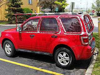
Here is my 2009 Ford Escape ready for chasing ... Hail grills have been installed on all the windows, with a quick "don and remove" shield above the windshield (removable for driving long distances to reduce fuel-consuming drag) that can be put on at times of large hail encounters. |
|
Starting the long drive out of Illinois and across Iowa, heading into Nebraska as the sky changes from clear blue sky to a thick deck of Altocumulus Castellaus (start of upper level wave moving in from the western USA coast). |
GALLERY FOR MAY 19, 2014
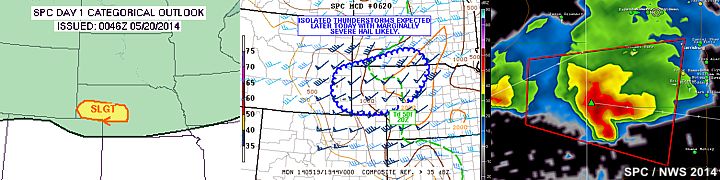
In the graphic above, the SPC convective outlook is shown to the left, depicting a very small, if not one of the smallest, slight-risk outlooks over the Nebraska panhandle. This area also had a tornado probability of 2%, with a 5% wind and 15% hail (hatched) probability. Later in the day, this area was reduced to a 'see text', and the tornado probabilities were removed as well as the significant hatching for the 15% hail with the 5% wind remaining. In the middle image, we see the mesoscale discussion in the same area that was issued (MCD 620). To the right is a NWS reflectivity radar image of an LP supercell storm that formed south of Scottsbluff and tracked ESE to near Chappell, NE.
|
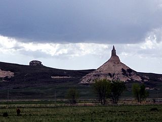
Here is a view of Chimney Rock to the southeast of Scootsbluff, Nebraska while waiting for storms to develop. |
|
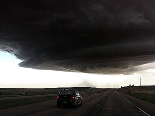
This is a picture of an intense, high-based LP supercell storm developing in Banner County, Nebraska near Harrisburg looking south on Highway 71. Very impressive striations and developing RFD. |
|
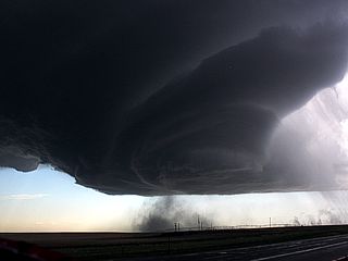
Strong rotation and RFD dust getting kicked up by the intense mesocyclone as it was entering southeastern Banner County, Nebraska. |
|
Here is a view from near Kimball, Nebraska looking east and upwards towards the intense updraft of the supercell storm. The hail shaft, with at least 2" hail, can also be seen just above the end of the road and to the left. Note the inflow banding / tails to the right! |
|
As the supercell storm evolved to a line segment, a strikign shelf cloud is presented by the storm as viewed from the east from near Chappell, Nebraska at dusk. This storm was produceing hail as large at golfballs and 70+ MPH winds at this point. |
GALLERY FOR MAY 20, 2014
In the images above, to the left is the SPC's slight-risk outlook (that had probabilities for 2% tornado, 15% wind, and 15% hail) extending from NE Colorado to east-central Wyoming. The annotated middle image is the visible satellite, showing two supercell storms close together moving out of eastern Wyoming and into Nebraska near Scottsbluff. Another multicell cluster (with a supercell on its southern end) is also propagating off the Palmer divide in NE Colorado as well. To the right is the base reflectivity NWS radar image of the two HP supercell storms near Scottsbluff, Nebraska at about the same time of the visible satellite image (evening).
|
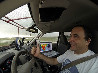
Here is my "office" during my chase trips! |
|
Wall cloud and supercell updraft base near Hawk Springs, Wyoming on May 20, 2014. |
|
This was rotating hard, until the wet RFD got too strong and sheared it apart. Lookign west from near Highway 158 NE of Hawk Springs, Wyoming on May 20. |
|
Powerful RFD and downdraft "hole" in the cloud base. This was SW of Haig, Nebraska. Note the dust plume. May 20, 2014. |
|
View of convective complex of storms SE of denver, CO (from near Dalton, Nebraska) on May 20, 2014. These storms are about 150 to 200 miles away - Thanks to the awesome high plains visibility! |
GALLERY FOR MAY 21, 2014
In the graphic above, the SPC tornado outlook of 10% is shown in the left image, bulls-eyed over NE Colorado. This area was in a slight risk outlook, with an additional 15% wind and 30% (hatched) hail probability. In the middle image, the mesoscale discussion (MCD 636) is shown, with the greatest tornado threat near the Palmer Divide east of Denver, and a lesser threat area extending into Wyoming due to upslope wind flow and an outflow boundary. Despite tornadic storms forming east of Denver that day, another tornado developed well to the north near Chugwater, Wyoming (just north of the 2% outlook on the left image in Wyoming). The right image is the incredible NWS radar (base reflectivity) presentation of the tornadic supercell moving across Denver and Arapahoe Counties, and over Denver International Airport, during the late afternoon. The "hole" of the radar image is the "cone of silence" directly above the radar antenna, which cannot "look" straight up. The actual tornado, if any, is rain wrapped and should be just west (left) of the cone of silence "hole".
|
This was a rotating wall cloud, probably not a tornado ... This was the same feature posted by some people at Denver International Airport. |
|
Funnel cloud / possible firsrt tornado from the supercell over Denver International Airport (reported near Towers road) |
|
Heading east out of Brighton with an incredible radar presentation of the storm on my screen! |
|
Another rotating funnel / tornado looking south towards the HP notch of the storm. This east of Denver International Airport. |
|
Hail fall covers ground with some stones up to 2 inches near Commerce City, Colorado just west of Denver International Airport. |
|
From Highway 36 near Byers, Colorado ... The hail "swath" is pretty ominous 2-3 hours after an HP supercell dumped nearly a half foot of hail on the landscape! |
|
The melting hail and passage of a tornadic HP supercell leaves its mark on the landscape. This caused a massive hail fall and flash flooding north of Byers, Colorado. |
GALLERY FOR MAY 22, 2014
The graphic above shows the setup for the final chase day of this trip, which was cut short afterwards. The SPC slight-risk was in place extending from Wyoming all the way down to New Mexico. A 2% tornado (shown in the left image) was in place over NE Colorado. Also, a 15% wind and hail probability was also forecasted. In the middle image, MCD (mesoscale discussion) 656 is shown, highlighting another round of storms developing due to heating, upslope winds, and the weakening lee trough. Note the DCVZ (Denver Cyclone Vorticity Zone) developing NE of Denver with NE winds NW of Denver near Boulder, but SW winds to the east. To the right is one of the HP supercell storms evolving to an MCS (multicell cluster) near Deer Trail later that day in a NWS radar reflectivity image.
|
An LP supercell storm develops right over downtown Denver (the skyline is to the lower right) with the best structure of the day. |
|
Not sure what this "feature" was looking far to the southwest at some storm cells developing south of Denver and east of the front range. |
|
This is NOT a tornado, but rising scud along a gust front ahead of a supercell storm embedded in a cluster of severe storms SW of Byers, Colorado. |
|
Some flash floowing between Strasburg and Bennett Colorado. |
|
An accident ocurred on I-70 just east of Bennett, Colorado due to hydroplaning on rain and hail soaked roads. Dan Shaw is to the left of th group of people helping out. |
GALLERY FOR MAY 23, 2014
|
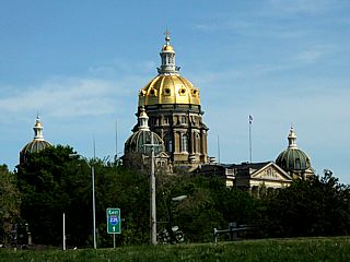
May 23 was a cut-the-trip-short and travel day returning to Chicago thanks to unfavorable / marginal chase prospects in the desert SW USA with weak setups / ridging. In this picture, the capital building of Des Moines, Iowa looms over Interstate 235 as I pass through downtown. |
CHASE MAP FOR JUNE 2-4, 2014
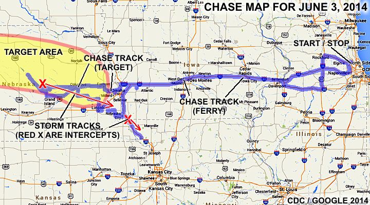
The chase map shown here is for a mini chase trip to the Central USA from June 2 to June 4, 2014. The blue lines indicate the chase / ferry (travel) tracks and the red "X"'s where storms were intercepted. This yet another chase for 2014 involved a drive to and from the NW Suburbs of Chicago and the target areas chased, mainly in central to eastern Nebraska. On Monday, June 2, I left Chicago and headed west through Iowa and into Omaha by about midnight for the night. Tuesday, June 3 was the main chase day, with an initial moderate risk (high risk later for extreme wind probabilities), mainly across an area from west of Norfolk and Omaha and north of I-80 to near Valley and Greely counties. Supercell storms were intercepted, but they quickly evolved to an MCS, with two weak tornadoes / gustnadoes observed. Upon wrapping up the chase late on June 3, I headed southeast of Omaha and into extreme NW Missouri / SW Iowa, then retreated back north into Iowa and east a bit for the night near Avoca. Leaving very early on June 4, I was able to make my way back across Iowa and into Illinois, and was at my office at about lunch time in Chicago!
CHASE TRIP CHRONOLOGY FOR JUNE 2-4, 2014
I began this highly rushed chase trip on Monday afternoon, June 2, after clearing my work schedule in Northwestern Chicago and arriving earlier that same day from a trip to Florida. I left Hoffman Estates, IL afer work at about 5 PM, heading west on I-90 to Rockford and south on I-39 towards I-80 west. A closed exit (I-39 interchange from I-90 and Highway 20) caused a 30 minute delay / detour through Rockford. Some low topped storms with supercell features were noticed west of I-39 and near Rochelle during the drive south. I headed west on I-80 across the Mississippi River through Davenport and into Iowa, then across the entire state on I-80 through Des Moines, and finally into Omaha via I-29 / I-680, staying in NW Omaha for the night.
On Tuesday, at roughtly 9 AM, I forecasted as well as prepared the vehicle (including the window hail guards). The storm prediction center had an area stretching from near Valentine, NE to western Iowa in a moderate risk. The tornado probabilities were 10% (hatched for some significant), with a 45% hail and 45 wind probability, also hatched. This outlook product was actually updraded to a high-risk, but with the same hail and tornado probabilities, but with a wind probability of 60% (hatched for extreme-damaging winds possible). A warm front / stationary boundary was draped across northern Nebrsaska from near Velantine, to just north of Omaha near Blair. A low-level jet / confluence axis was noted to intersect this boundary to the southwest of O'Neill and about 100 miles either side of there. A low pressure area was also developing to the west near the WY / CO / NE tri-state area with a dryline extending into W Kansas to the south. Upper air support was provided by an upper trough to the west and speed-max progged to pass over the area later in the afternoon. This presented a complicated forecasting scenario.
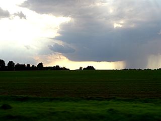
The plan of the day was to head west and northwest to target an area anywhere from Norfolk to O'Neill. I left the hotel and headed west out of NW Omaha along Highway 64 to 275, then north and west on 275 / 30 into Columbus to look at data and have lunch. Meanwhile, an intense elevated storm well to the north of the warm front / boundary was producing 100 MPH winds and baseball sized hail. This was not a target storm, but a mere effect from the low level jet and warm advection above the cooler air mass to the north. I stuck to my target, heading out of Columbus via 30 and 92 to St Paul. Sure enough, storms began forming west of O'Neill and near Ainsworth. I continued northwest on 281, then Highway 11 towards Ord and eventually southeast of Burwell. This is where an intense HP supercell storm was intercepted. The storm quickly became outflow dominant, despite turning right, and propagating east and southeast along the boundary, which was oriented from the NW to SE. From this point on, the chase returned pretty much back SE down Highway 11, and back towards highway 281 and 22 through Wolbach, continuing east on 22 to near Fullerton.
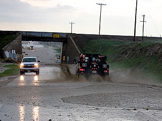
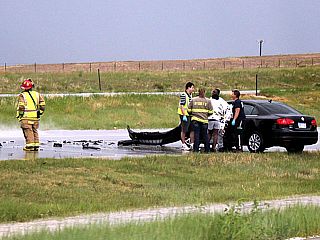
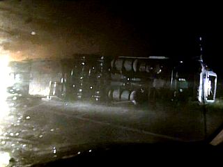
I continued east and northeast on Highway 30 to Highway 77 south, indirectly penetrating the core of the HP storm in some cases. Two weak tornadoes / gustnadoes were observed in Valley and Greely counties. Upon reaching Highway 77, I dropped south to near Lincoln and let the storm go east and northeast. It was not very well organized. I went back NE on I-80 out of Lincoln and stopped for fuel, then dropped south on highway 63, east on 34, then south on 50 to Highway 2 to go east across the Missouri river back into Iowa. The initial HP storm was still intact, and trying to re-intensify at the time, but detours and construction made it nearly impossible to re-intercept it near dusk (let alone it moving ESE at 50 MPH). Another batch of storms, including an HP supercell developed SW of Nebraska City. Now after dark, I headed south on I-29 into extreme NW Missouri figuring I can make it to near St Joseph and head east ahead of all the storms. I penetrated some severe storms, with 65-70 MPH+ winds, and came across an overturned semi on I-29 near Rock Port.
With it impossible to get ahead of anything, and not wanting to deal with a potentially tornadic HP storm at night, I turned around near Craig and headed back north on I-29 into Iowa. I exited the storms back southeast of Omaha, with incredible lightning from more storms to the NW, then took I-29 to I-80 east, and through lighter rain, eventually reaching Avoca, Iowa after midnight, spending the night there. After a short and well needed sleep, I left Avoca at about 6 AM, heading east on I-80 back through Iowa and chose I-88 back into Illinois near Davenport. I took I-88 all the way back to the W Chicago suburbs, then north along Highway 59, and was back at my office in Hoffman Estates by about 12 PM on June 4 (Wednesday)! Total mileage on the vehicle was 1,535.2 miles.
JUNE 2-4 CHASE MAIN PARTICIPANTS
| CHASER NAME | HOME / BASE CITY | CALLSIGN | CHASE DATES | OCCUPATION |
| CHRIS COLLURA | CHICAGO, IL | KG4PJN | 6-2 TO 6-4 | IT CONSULTANT |
FORECASTING AND TARGET AREA - JUNE 3
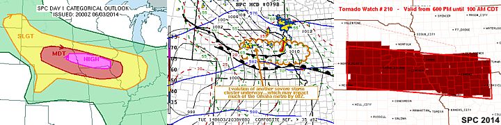
In the image above, the high-risk and moderate risk areas are shown for the afternoon of June 3 are shown to the left. The tornado probabilities were a bit low at 10% (but hatched), as this was mainly a wind event forecasted) at the same time. The middle image is one of the mesoscale discussions (MCD 798) showing the position of the boundaries and fronts with expected storm evolution over central / eastern Nebraska. One of several tornado watches is shown (WW 210), that was also in effect for the area in the right image.
STORM RADAR / SATELLITE IMAGERY - JUNE 3
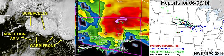
In the image above, we see the visible satellite during the evening of June 3, with storms erupting over Nebraska to the left. In the middle is a radar reflectivity image showing the HP supercell near Valley and Greely counties in Nebraska. To the right is the storm reports (totalling 388) for June 3 as per the storm prediction center. A total of 16 tornadoes were reported, along with 193 wind reports (13 significant), and 179 hail reports (38 of which were significant).
DETAILED CHASE LOG FOR JUNE 2-4, 2014
1). June 3, 5:30 PM - Interception and observation of a very severe and tornadic thunderstorm from southeast of Burwell and near Ord (Valley and Greely Counties), Nebraska and well to the east and southeast through Columbus and eventually to the east of Lincoln. The storm was an HP supercell storm, which became quickly outflow dominant, and the core of it was indirectly penetrated as well. Conditions encountered were 65 to 75 MPH winds, frequent lightning, torrential rains, and hail up to nickel sized. Two weak tornadoes / gustnadoes were observed with this storm as well in Greely county. The main core had hail to baseball sized and winds over 80 MPH. Flash flooding and trees down was also noted with this storm. The storm was caused by a low pressure trough, surface heating, upper trough, warm-front, and outflow boundary interactions. Documentation was HD video and stills. A 2009 Ford Escape was used to chase the storms. A tornado watch was also in effect for the area until 7 PM CDT.
2). June 3, 10:00 PM - Penetration of a severe thunderstorm from along Interstate 29 from southeast of Nebraska City, and into extreme NW Missouri / SW Iowa in Atchison and Holt counties, respectively. The storm was a multicell severe storm that was northeast of an HP Supercell storm to the SW over Richardson County, Nebraska. Conditions encountered were frequent lightning, 70+ MPH winds, torrential rains, and dime sized hail. A semi truck was also seen blown over near Rockport with this storm. The storm was caused by a low pressure trough, surface heating, upper trough, and outflow boundary interactions. Documentation was HD video. A 2009 Ford Escape was used to chase the storms. A tornado watch was also in effect for the area until 1 AM CDT the following day.
This concludes the chase log for the central US Plains and Midwest chase trip for June 2 to June 4, 2014. The summary includes a total of 2 severe thunderstorms and 2 weak tornadoes. The main chase vehicle conducting this chase was a 2009 Ford Escape. This information was prepared exclusively for the National Weather service and the team of Skywarn storm spotters.
GALLERY FOR JUNE 2, 2014
|
Here is a view of a weakly rotating low-topped storm west of I-39 in Illinois and to the west of Rochelle as I was driving enroute for the next day's chase. |
GALLERY FOR JUNE 3, 2014
|
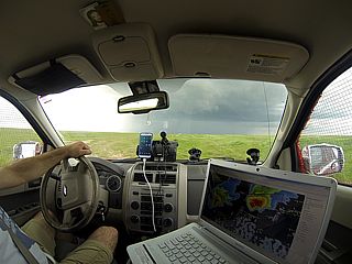
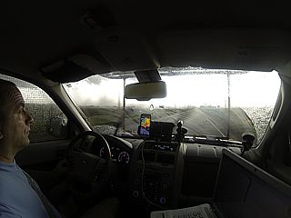
Myself chasing storms in central Nebraska on June 3, 2014 in moderate / high risk. |
|
Intense RFD in supercell storm northwest of Ord, Nebraska before becoming undercut by outflow. |
|
Interesting funnel and gustnado developing on the southern side of an outflow dominant supercell storm in Greely County, NE. |
|
Another gustnado / weak tornado on the southern side of an outflow dominant HP supercell storm in Greely County, NE. |
|
Semi truck overturned after being blown over on I-29 north of the IA / MO border in the southbound lane. Winds near 80 MPH passed through this area. |
GALLERY FOR JUNE 4, 2014
|
Think of THIS next time you are stuck in traffic! This is what rush hour looks like in rural Nebraska / Iowa. |
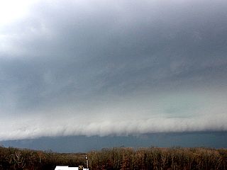
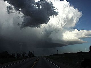
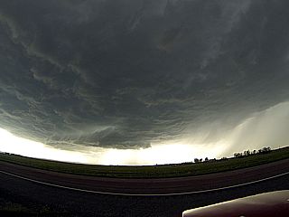
CHASE MAP FOR JUNE 13-17, 2014
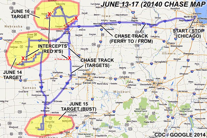
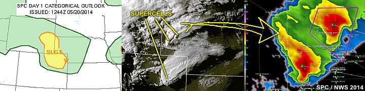
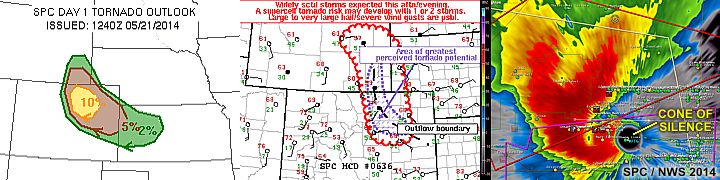
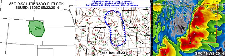
The chase map shown here is for a mini chase trip to the Central USA from June 13 to June 17, 2014. The blue lines indicate the chase / ferry (travel) tracks and the red "X"'s where storms were intercepted. This yet another chase for 2014 involved a drive to and from the NW Suburbs of Chicago and the target areas chased, with the chase areas being in Nebraska and Kansas. On Friday, June 13, I left Chicago and headed west through Iowa and into Lincoln by about 1:30 AM the next day for the night. Chasing was over the next few days (near Smith Center, KS and Red Could, NE in June 14th, north-central OK on June 15 for a cap "bust", and the ultimately successful tornado "fest" in Nebraska and Iowa on June 16). June 17 was the return trip to Chicago. The red "X" in Nebraska in the June 16 "target area" was the violent cyclic supercell that struck Pilger, NE. The dashed lines show the approximate storm tracks.
CHASE TRIP CHRONOLOGY FOR JUNE 13-17, 2014
This chase trip was to be a late "spot" chase for a few days in Mid June 2014. I began the trip by leaving right from my work at Chicago's NW Suburbs (Hoffman Estates) during the late afternoon of June 13 and headed down Highway 59 to Interstate 88 west. I took I-88 west to I-80 near Davenport, Iowa, and continued on I-80 across Iowa and through Des Moines. My attempt to stay in Avoca, Iowa failed due to lack of hotel rooms, but I finally found one in Lincoln, Nebraska (arriving there well after midnight) after searching westward through Omaha on I-80. This just was to put myself in a better position for the target area(s) on June 14 (moderate risk chase day from S-Central Nebraska to N-Central Kansas).
June 14 was a busy moderate risk chase day that eventually was awarded with a couple of brief tornadoes well after dark. I started the day in Lincoln, and checked data (forecasted). It appeared the beast area to be was from about York to Grand Island, then southward as far as Smith Center and near the Highway 281 corridor. This area was ahead of a forecasted triple point (lee cyclone to the west), and characterized by strong moisture advection under a breaking cap ahead of a Pacific cold-front by afternoon. Meanwhile, the Storm Prediction Center had this area outlooked in a moderate risk with attendant 45% hail and wind probabilities (both hatched), as well as 10% probability of tornadoes. By mid afternoon, I headed west out of Lincoln on I-80 to York, Nebraska for lunch and to prep the vehicle hail guards.
I headed west on I-80 to Grand Island to wait to see what happens. A convergence axis was setting up (pre-frontal) just west of there, visually marked by cumulus (with altocumulus castellanus above that as upper air support started arriving from the west aloft). By about 4:30 PM, the cumulus became agitated and the cap was breached by about 5 PM, with cells developing NW of Hastings and a "tail" end storm initiating about 60 miles to the SW near Smith Center in Kansas. I met up with two other chasers, John Thomas and Charles Hamilton in their vehicles near Hastings who would join me on the rest of this chase. With them in my caravan, we headed down 281 through Hastings, and into Kansas near Red Cloud to target the better storm to the SW (which already was producing a land spout tornado).
At this time, the SPC also issued mesoscale discussion 994 and subsequent tornado watch box 294 for this area as well. The storm being targeted was a supercell storm and was observed from near Smith Center, Kansas and followed several hours back north along and near 281 to near Clay Center along Highways 14, 74, and 6. Tornadoes were observed with this storm around 9:45 to 10 PM near Harvard, Kansas. I decided to leave the storms after that, as well as rapid MCS evolution finally was occurring, by heading back east to Highway 14 and 6, eventually with Highway 81 south to Salina, Kansas for the night. During the drive south on Highway 81, the MCS and strong winds caught up with me from the west (small hail and 60-70 MPH gusts) near the KS / NE border. I got into Salina for the night at about 1:30 AM June 15.
June 15 was to be a marginal chase day, but I decided to check out the target area near the north-central OK / Kansas border. This day was to be the infamous "cap" bust type of day. I forecasted and decided on the north-Central Oklahoma target, since a warm front / stalled outflow boundary was in that area, and surface heating should drive storms if the cap could be broken before strengthening later that evening. The SPC had a slight risk outlook for this area, with a 5% tornado probability and the wind / hail probabilities both 15%. I left Salina and headed down I-135 into Wichita for lunch and to check data again. I continued south out of Wichita via Highway 81 (west of I-35 toll), past Wellington and into Oklahoma by the afternoon, taking Highway 15 / SR 74 south.
I headed a bit west to just east of Enid on Highway 60 and waited a few hours watching towering cumulus south of the boundary. By about 6 PM, it became apparent the strengthening cap (inversion aloft) was going to prevent storms that day. Cumulus almost went up to the LFC (free convection) but was suppressed by the warm layer aloft. No MCD nor watches were posted by SPC and clouds began dissipating after 6:30 PM CDT. Calling it a "bust", and slightly sun burned, I decided to head back up the same route back to Wichita for the night early, anticipating a long drive and early departure the next day for much better promise for chasing farther north (Nebraska / Iowa for June 16). I headed back up Highway 81 to Highway 400 in Wichita, and spent the night there.
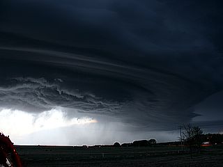
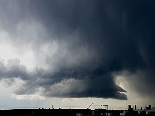
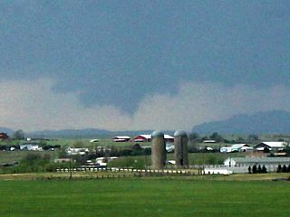
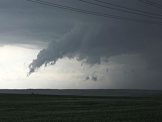
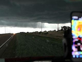
June 16 was to be one of the best (if not the best) chase days of my storm chasing career, with multiple violent tornadoes intercepted in Nebraska. I woke up in Wichita very early, packed up, did a brief forecast, and left via I-35 northeast through Andover. I continued up I-35 to I-335 into Topeka, then Highway 75 north into Nebraska City, then east to I-29 north into Iowa to make the target area(s). I reached the Omaha area (on the Iowa side) just after noon. The storm prediction center had a moderate risk in place for the eastern third of Nebraska, more than half of western Iowa, and a small portion of southern Minnesota. The tornado probabilities were initially 10% and updated to 15% (hatched for significant), mainly over eastern Nebraska and western Iowa. The hail and wind were both 45%, with the hail probability hatched.
An on-going and intense elevated HP supercell was encountered on the southern end of a cluster of storms north and northeast of Nebraska, and followed into Iowa before it weakened near Harlan via I-29 to I-680 and eventually northeast to Highway 59. The SPC had severe thunderstorm watch #301 in effect until 2 PM for this area as well. I left that storm as that was NOT the main storm of the day, the primary target was still east-central to NE Nebraska. I continued to near Denison, then highway 144 / 175 through Onawa and back into Nebraska to highway 51 west. A small cluster of convective showers developed near Norfolk by about 3 PM CDT. This was an isolated shower, and possibly initiation for a larger storm. I did not want to be "suckered" to the north and east to near the MN border was, so I stuck to my target area.
The storm prediction center issued mesoscale discussion MCD 1015, and subsequent PDS (particularly dangerous situation) tornado watch #303 valid from 3:10 PM to 10 PM CDT. I continued west along Highway 151 to Highway 275, and at this time (roughly 3:30 PM), it became apparent that a supercell storm was forming from the cluster of storms to the east of Norfolk, NE. Over the next few hours, I intercepted the supercell storm from east of Stanton, NE via SR 15 / 32 and SR 57 back to Highway 275 east. The violent Stanton wedge tornado was observed, as well as the violent "twin" Pilger tornadoes, and some more multiple tornadoes east and north from there to near the Winnebago Indian Reservation. These tornadoes were significant and very destructive. Pilger, NE was destroyed by one of the "dual" tornadoes observed.
The supercell storm was followed northeastward via SR 9 / 35 and to just southwest of Sioux City, Iowa. The last tornado from the storm was observed about 7 miles southwest of Sioux City. After that, roughly 7 PM, I continued into Sioux City to near I-29 in Iowa across the MO River. I stopped to check data again and remove some hail guards off the front windows of the vehicle, wrapping up the chase. I continued south down I-29 to I-680 east, then I-80 east all the way through Des Moines and into Williamsburg, IA for the night at just before midnight. I left Williamsburg early on June 17 and headed east on I-80 to I-88 in Davenport, then back east on I-88 into Chicago and north on Highway 59. I arrived at my office in Hoffman Estates by about 9:30 AM June 17. This concluded the trip, with a total of 2515.4 miles.
JUNE 13-17 CHASE PARTICIPANTS
| CHASER NAME | HOME / BASE CITY | CALLSIGN | CHASE DATES | OCCUPATION |
| CHRIS COLLURA | CHICAGO, IL | KG4PJN | 6-13 TO 6-17 | IT CONSULTANT |
| JOHN THOMPSON | CLINTON, MO | TRCF5 | 6-14 | EMERGENCY MANAGEMENT |
| CHARLES HAMILTON | LEXINGTON, MO | N/A | 6-14 | EDUCATION |
FORECASTING AND TARGET AREA - JUNE 14
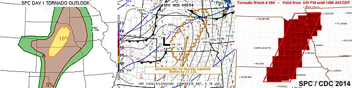
The images above, from left to right are the SPC tornado outlook, mesoscale discussion #994, and subsequent tornado watch box 294 for the target areas on June 14, 2014. The narrowed-down target area was pretty much south of I-80 and near Hastings, Nebraska, and southward to just south of Red Cloud, Kansas. The best storms (for tornadoes) developed on the southern portion of the mesoscale discussion graphic. Other violent storms developed farther north, one producing hail over 4" in diameter to the NW of Hastings.
FORECASTING AND TARGET AREA - JUNE 15
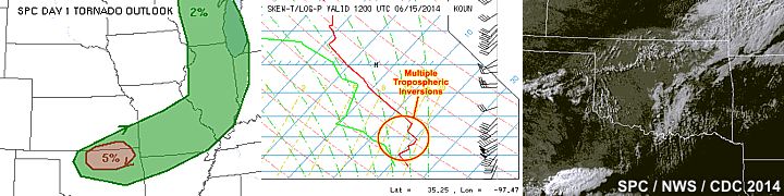
The images here depict a "busted" target area (no storms developed, despite the possibilities depicted by SPC). To the left is the 5% tornado "bull’s-eye" in north-central Oklahoma and part of a large slight-risk area. In the middle image, a very strong cap is shown by the inversion aloft, which essentially prevents updrafts from reaching the LFC (level of free convection). Note that there are actually multiple tropospheric inversions present, constituting a nearly un-breakable cap. To the right is the capped atmosphere with scattered cumulus, haze, and no storms. Note that the only storms are confined to far SW Texas, where upper air support was nearly non existent, and the dryline provided enough forcing for some small thunderstorms there.
FORECASTING AND TARGET AREA - JUNE 16
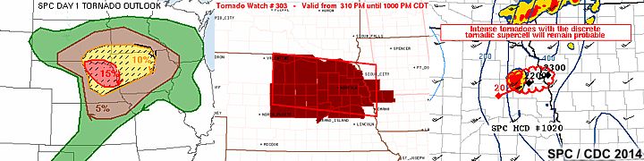
The images above depict the setup that lead to the deadly tornadoes in Nebraska later that day. To the left, is the 15% (hatched for significant) tornado probability issued with the moderate risk as of 16:30z by SPC (Storm Prediction Center). The middle image is the PDS (Particularly Dangerous Situation) tornado watch box #303. To the right is one of many mesoscale discussions issued that day, but this one in particular was issued for a single tornadic supercell storm trekking across Nebraska.
DETAILED CHASE LOG FOR JUNE 13-17, 2014
1). June 14, 6:00 PM - Interception and indirect penetration of a very severe and tornadic thunderstorm from near Smith Center, Kansas in Smith County and near Highways 36 and 281, and points northeastward through Red Cloud and into Nebraska near Clay Center and Harvard near Highway 6 in Adams County. The storm was a supercell storm (classic structure at times) with a striking visual (stacked plates) appearance. A small landspout type tornado was missed early on in the storms lifecycle. Strong winds (near 60 MPH), hail to 1", heavy rains, and frequent lightning was observed near Smith Center, Kansas during an indirect penetration of the storm along Highway 36. Later on, a series of small tornadoes under a very large wall cloud were observed around 10 PM in Nebraska near Adams County and NW of Harvard, Nebraska. The storm was caused by surface heading, and Pacific cold-front / dryline interaction, low pressure area, and upper trough. Documentation was HD video, audio, and stills. A 2009 Ford Escape was used to chase the storms. A tornado watch was also in effect for the area until 12 AM CDT the next day.
2). June 15, 12:00 AM - Penetration of severe thunderstorms along Highway 81 from near the KS / NE border and to the north of Belleville in Republic County. The storm was a bowing section of a very large multicellular MCS moving in from the west. Winds gusting to near 70 MPH, heavy rains, frequent lightning, and small hail were encountered in this area. The storm was caused by a low pressure area, upper trough, and advancing Pacific cold front. A 2009 Ford Escape was used to chase the storms. A severe thunderstorm watch was also in effect for the area until 5 AM CDT.
3). June 16, 12:30 PM - Interception and observation of a very severe thunderstorm from along Interstate 29 near and Northeast of Omaha, Nebraska in Douglass County and Pottawattamie County in Iowa and northeastward to near Harlan in Shelby County and Highway 59 / SR 44. The storm was an elevated HP supercell storm, that evolved to LP via downscale evolution and eventually dissipated near and east of Denison. Originally, this storm had hail exceeding 3 inches when it was in Douglas County, NE. The main core was not penetrated, but small hail, 50 to 60 MPH winds, frequent lightning, and heavy rains were observed with this storm. The storm also had a striking visual appearance (stacked plates and "mothership" appearance as it was undergoing downscale evolution near Harlan, Iowa. The lower base (and RFD shelf) of the storm became de-coupled from the upper portion of the supercell storm, which had striations and a pronounced RFD clear slot. The storm was caused by a warm front (to the south), low-level jet, low pressure trough, surface heating, and an upper trough. A 2009 Ford Escape was used to chase the storms. Documentation was digital video and still photos. A severe thunderstorm watch was also in effect for the area until 12 PM CDT.
4). June 16, 4:30 PM - Interception and observation of an extremely severe and violent tornadic thunderstorm from near Stanton, Nebraska in Stanton County near SR 57 and Highway 275, and northeastward past Pilger, Nebraska and eventually to about 7 miles southwest of Sioux City, Iowa in Dakota County near Emerson along SR 35. The storm was a violent classic and cyclic supercell that produced at least 4 violent tornadoes (one EF-4 wedge near Stanton, two dramatic and intense EF-4 "twin" tornadoes near Pilger - One taking a direct hit on that town causing at least EF-4 damage and fatalities, and yet another EF-4 southwest of Thurston in Wayne County). The storm produced a "tornado family" with at least three tornadoes on the ground at the same time. While the Stanton EF-4 tornado (which was nearly a mile wide during its wedge phase) was roping out north of the intersection of Highway 275 and SR 57, Pilger, NE was being destroyed by one of the violent "twin" tornadoes that were in progress eastward near Highway 275. These two tornadoes were very large and violent stovepipes (almost wedges) that at one point were nearly identical, and rotating slowly around each other ("Fujiwhara" effect), with the tornado that hit Pilger becoming shrouded in debris. These two tornadoes continued to the NE, with the eastern Pilger tornado becoming "involved" with its western "twin" and evolving to a mile+ wide wedge north of Highway 275. With this wedge tornado (now a single vortex, with possibly a brief satellite / third tornado to its west prior to the merger) becoming rain wrapped and occluding, two more separate tornadoes developed to the east, one a narrow rope that evolved to a stovepipe, and yet another cone / wedge tornado developing southwest of Thurston. The view north of Highway 275 clearly showed three of these tornadoes, with the stovepipe in between them. Finally, after a cycle-down, the supercell storm again produced a smaller tornado about 7 miles SW of Sioux City, and northwest of the Winnebago Indian Reservation. After that the storm underwent downscale evolution and dissipated near Sioux City, Iowa. The core of this storm was avoided, but hail to quarter sized was observed with heavy rains and frequent lightning. Winds, especially RFD and inflow, were noted gusting from 70 to 80 MPH. The town of Pilger, NE took a direct hit from the western EF-4 (at least) tornado, killing at least 3 people and destroying most of the town. Destruction of the town was observed directly from Highway 275. The supercell also had a very impressive visual presentation, including striations and a "stacked plate" appearance. The storm was caused by a warm front / boundary interactions, surface heating, low pressure area, and an upper trough. A 2009 Ford Escape was used to chase the storms. Documentation was digital video, audio, and still photos. A PDS (particularly dangerous situation) tornado watch box was also in effect for the area until 10 PM CDT.
This concludes the chase log for the central US Plains and Midwest chase trip for June 13 to June 17, 2014. The summary includes a total of 4 severe thunderstorms and 8 tornadoes (many of which were significant / violent). The main chase vehicle conducting this chase was a 2009 Ford Escape. This information was prepared exclusively for the National Weather service and the team of Skywarn storm spotters.
GALLERY FOR JUNE 13, 2014
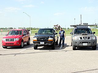
|
Here is a picture of two other chasers, John Thomas and Charles Hamilton in their vehicles near Hastings / Grand Island, Nebraska while preparing to chase. The chase trip started the night before (June 13) by driving from Chicago to Lincoln, Nebraska. |
GALLERY FOR JUNE 14, 2014
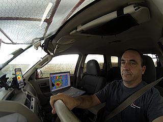
|
Myself again in my "office" for the day storm chasing (June 14, 2014). |
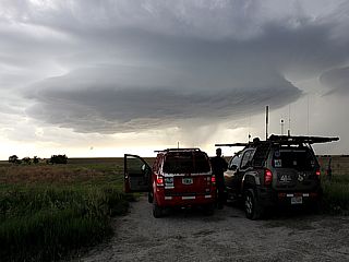
|
Northeast of Smith Center, Kansas - June 14, 2014. |
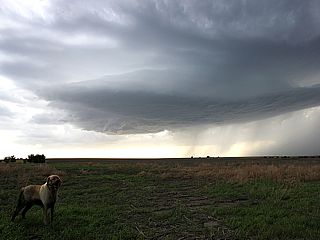
|
Who's dog is this? Anyway he stopped and said hello in front of a classic supercell storm northeast of Smith Center, Kansas - June 14, 2014. |
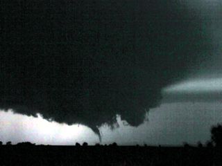
|
One of a few brief touchdowns north of Adams County, NE and west of Harvard, NE illuminated by continuous lightning (June 14 at roughly 10 PM CDT). |
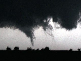
|
Wider view of one of a few brief touchdowns north of Adams County, NE and west of Harvard, NE illuminated by continuous lightning (June 14 at roughly 10 PM CDT). |
GALLERY FOR JUNE 15, 2014
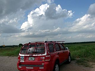
|
This is a picture of my vehicle while waiting for a cell to TRY to push through a strong capping inversion during a cap "bust" in north-central Oklahoma on June 15, 2014. No storms developed this day despite a slight risk in place. |
GALLERY FOR JUNE 16, 2014
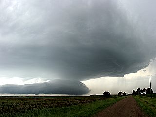
|
Elevated HP supercell storm (note the RFD with shelf cloud below it, de coupled from the storm). This storm produced 3.0 to 3.5" hail near Omaha, Nebraska earlier (around noon on June 16, 2014). |
|
Horeseshoe vortex in a cumulus field to the southwest of Sioux City, Iowa and near tyhe Nebraska border. June 16, 2014. |
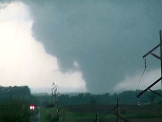
|
Stanton, Nebraska EF-4 tornado developing (June 16, 2014). |
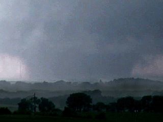
|
Stanton, Nebraska EF-4 wedge tornado close-up (June 16, 2014). |
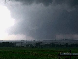
|
Stanton, Nebraska EF-4 tornado starting to occlude / become rain wrapped (June 16, 2014). |
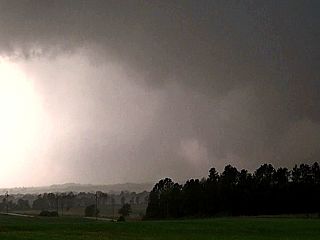
|
Stanton, Nebraska EF-4 tornado starting to occlude / become rain wrapped (June 16, 2014). |
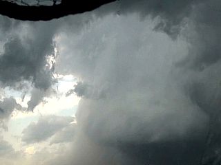
|
Powerful RFD behind Stanton, NE EF-4 tornado. June 16, 2014. |
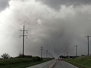
|
Stanton, NE tornado still barely visible with debris and hail wrap. At this time, new meso is producing tornado to east. June 16, 2014. |
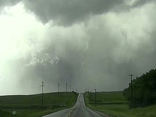
|
Another view of the Stanton, NE tornado later in it's life-cycle on June 16. Powerful RFD and clear slot! Time is roughly 4:05 PM CDT. |
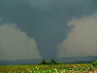
|
Pilger, NE tornado rapidly forms to the east while Stanton, NE tornado is still in progress. |
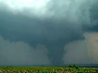
|
Pilger, NE tornado getting stronger at about 4:10 to 4:15 PM CDT on June 16. |
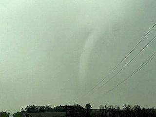
|
View of the Stanton, NE tornado roping out from elephant trunk on June 16. |
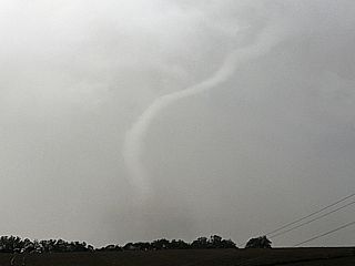
|
Another view of the Stanton, NE tornado roping out on June 16. |
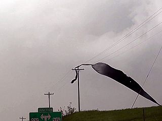
|
Debris in wires, Stanton, NE tornado has roped out completely (little needle funnel left in the center of the picture barely visible). June 16, 2014 at about 4:15 PM. Time to head east on Highway 275 towards Pilger, NE. |
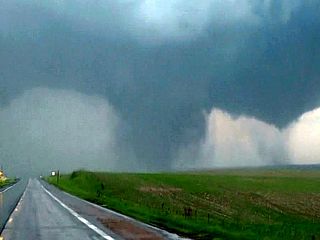
|
Pilger, NE tornado looking east on Highway 275 out of Stanton, NE on June 16 at about 4:15 PM CDT. |
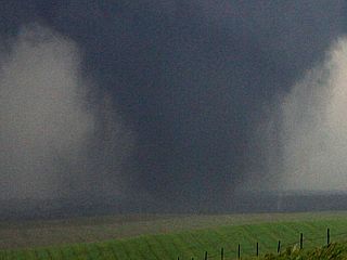
|
Pilger, NE is being hit here. The debris surrounds the tornado giving it an appearance like this. Roughly 4:20 PM CDT on June 16. This was at LEAST EF-4. |
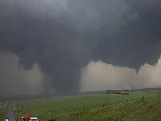
|
Pilger, NE tornado hitting town south of highway 275. Second tornado is starting to its south and southeast. |
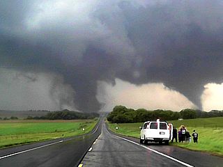
|
Now the "violent twins" begin as first tornado passes north of Pilger, NE. Folks with the tour groups got their "money's" worth on this trip! Roughy 4:25 on June 16, looking east on Highway 275. |
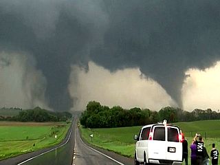
|
Another view of twin tornadoes near Pilger, NE as tour group watches in awe. BOTH rated EF-4 with one to the left possibly stronger. June 16, 2014. |
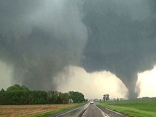
|
Debris filled left (remnants of Pilger, NE homes and such) with EF-4 "Pilger East" tornado south of 275. June 16, 2014. |
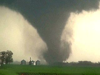
|
Close-up shot of the "eastern" Pilger, NE tornado "twins". EF-4 damage and winds occurring with this one too. June 16, 2014 at about 4:30 PM CDT. |
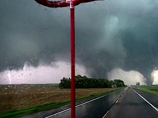
|
Lightning strike, left, and two "violent twins" north of Pilger, NE on June 16. |
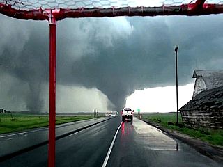
|
Second "Pilger East" tornado crossing Highway 275. |
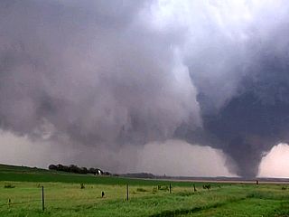
|
First violent tornado lifts a bit (but still broad but weaker) to the left as the second one intensifies a bit more at about 4:35 PM CDT on June 16. |
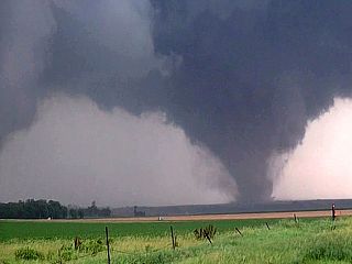
|
Second tornado now north of Highway 275. |
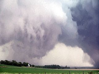
|
First tornado starting to intensify again. |
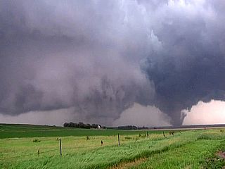
|
First tornado cycling back up with second one maxing out in intensity. |
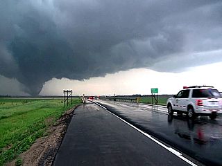
|
EMS / police vehicle rusing towards Pilger, NE behind the tornadoes at about 4:40 PM or so. June 16, 2014. |
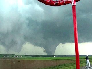
|
Twin tornadoes again in the field and farmland north of Highway 275, moving NE at about 30 MPH. |
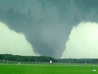
|
Second Pilger, NE EF-4 tornado close-up. |
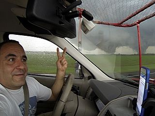
|
Here is a "selfie" picture of myself, commenting on the twin tornadoes while headed east on Highway 275 and north of Pilger, Nebraska. |
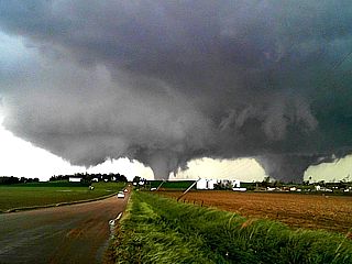
|
Twin tornadoes still moving north and "Fujiwhara" effect (they rotate around each other). Third possible tornado developing to ther left! Time roughly 4:45 CDT on June 16. |
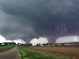
|
Lightning strike to the far right, farmstead destroyed in foreground. Possible 3rd tornado combining with stove-pipe to the left. Both EF-4 (at least). |
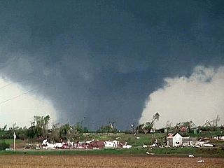
|
Destroyed farmstead and close up of violent tornado moving off to the NE. Other tornado will move around this one and get absorbed. |
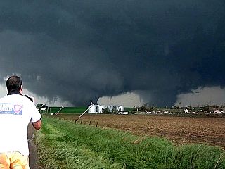
|
Myself taking pictures of the tornadoes. Time roughly 4:45 PM CDT on June 16. |
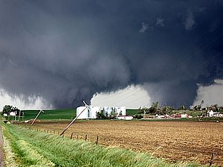
|
Same view looking northeast. Twin tornadoes in progress a couple miles north of Highway 275. Note devastated farmstead and downed power poles. |
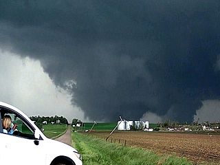
|
Owners of destroyed home / farmstead watch in horror. Two tornadoes "Fujiwhara" and begin to combine to violent mile+ wide wedge by 4:50 PM CDT. |
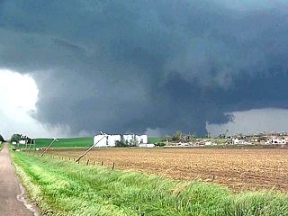
|
"Composite" wedge tornado forming ... This will continue NE and become rain-wrapped / occluded soon. June 16, 2014. |
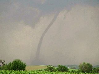
|
Thin rope develops east of the occluding wedge (formerly the twin tornadoes) and west of yet another tornado forming to the east! |
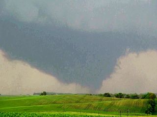
|
New tornado east of the developing rope tornado, both of which are east of the wedge which is becoming rain-wrapped. Time roughly 4:50 to 4:55 PM CDT. |
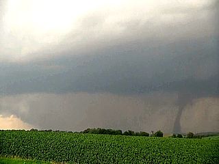
|
Massive wedge barely visible to the left and becoming rain-wrapped. Stove pipe forming from thin rope in between the wedge and eastern tornado. |
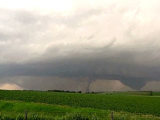
|
Full view of all three from left to right. Occluding wedge, stove pipe, and third eastern tornado forming. Time about 4:55 PM central. |
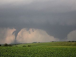
|
Stove pipe tornado intensifying from an elephant trunk just west of the new strong tornado to its east. |
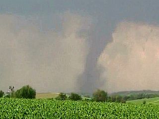
|
Closer view of the stove pipe tornado between the two. |
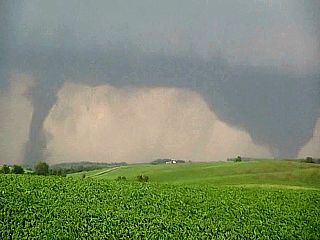
|
Wedge weakening and occluding to the west. Now we have 2 new tornadoes to the east, a stove pipe and cone tornado. These lated for about 5-10 minutes, and lifted by about 5:10 PM CDT. June 16, 2014. |
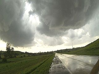
|
Storm wraps up again about 10 miles southwest of Sioux City, Iowa (on Nebraska side). Powerful RFD clear slot (view is to the SSW). Rapid rotation by about 5:30 PM CDT. |
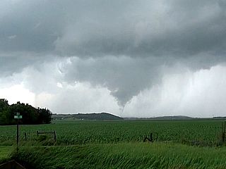
|
Final tornado lasts about 3 minutes 7 miles or so to the SW of Sioux City. Time is about 5:35 PM. |
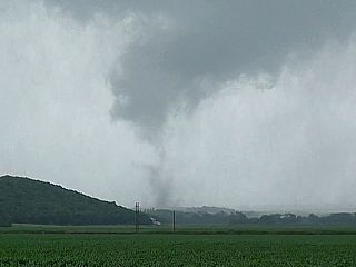
|
Closer view of the last tornado from this incredible cyclic supercell storm 7 miles or so SW of Sioux City, Iowa. Tornado lifted after 5:35 PM or so. June 16, 2014. |
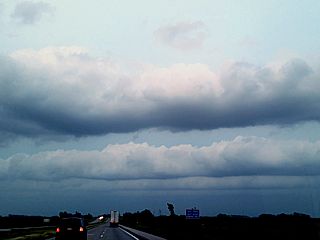
|
Here is the view of the sky to the northeast of Omaha, Nebraska over Iowa. Note the horizontal convective rolls (HCRs) as the low-level jet strengthens under a high (directional) shear environment. |
GALLERY FOR JUNE 17, 2014
|
Post tornado intercept steak once back in Chicago on June 17. Better later than never. |
CHASE MAP FOR JULY 12, 2014
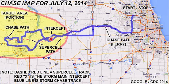
The chase map shown here is for a one-day chase trip to the Central USA (Iowa and western Illinois) on July 12, 2014. The blue lines indicate the chase / ferry (travel) tracks and the red "X" is where a storm was intercepted. This also was "local" and involved a drive to and from the NW Suburbs of Chicago and the target area chased, mainly from eastern Iowa to western Illinois. I left Chicago and headed west to eastern Iowa (near Davenport) and followed an intense supercell storm back across the Mississippi river near Clinton and back into Illinois to near Morrison. Upon wrapping up the chase on July 12, I headed back east on I-88 and into the Chicago area for that same night.
CHASE TRIP CHRONOLOGY FOR JULY 12, 2014
This was a one-day spot chase that left my area in the northwest Chicago suburbs near Hoffman Estates and returned later on that night with a successful chase in eastern Iowa and western Illinois. A friend I work with was also in town from Florida, and joined me on this chase (Jeffrey Lam). I left Hoffman Estates via Roselle Road to Highway 20 after lunch, and headed to Highway 59 then Interstate 88 west to near the junction of Interstate 80 and stopped for fuel. I continued west across the Mississippi river into Iowa (again for this year) and stopped at the Iowa 80 truck stop near Davenport to review data. It became apparent that many storms would develop in Iowa, but the more isolated and discrete storms may develop on the eastern side of the "target area" for the day.
By about 4:30 PM, the Storm Prediction Center has a slight risk in place, with a 5% tornado probability in place across much of Iowa and into western Illinois. A differential boundary was draped across eastern Iowa with a weak cold front advancing SW from the west. Forecasting showed an instability axis and backing of the surface flow over the eastern part of the state, so the plan was to not venture too far west. SPC issued mesoscale discussion #1345 and subsequent tornado watch box #411 for the areas in eastern Iowa and into western Illinois. By about 5 PM, a promising updraft rapidly went up northwest of Davenport and to the southwest of Dixon. I headed up country road Y-40 to near Highway 30 near Wheatland, then east to Highway 61 near Dewitt. Heading south on Highway 61, the intense core of the developing storm (now severe) was penetrated, with strong winds and hail in near zero visibility.
I continued south on Highway 61 to north of Davenport, and east via country roads F45, Z16, and Z30 east and north to near Highway 67, then eventually back east through Clinton, Iowa on Highway 30 to cross the Mississippi River back into Illinois. The storm was lost visually passing through Clinton, but re-acquired when going down Highway 23 towards Fenton, Illinois. The route continued up Route 2 south of I-88 and met up with the storm along I-88 and near Highway 30 to the south of Morrison, IL and towards Rock Falls. This is where the most intense part of the storm was encountered, with a possible weak tornado forming there just before 7 PM CDT. The storm weakened after that, and was followed east on Highway 30 to Interstate 39. At this point, I headed back up I-39 to I-88, returning east to Highway 59, and back to Hoffman Estates by late evening (10 PM or so).
JULY 12 CHASE MAIN PARTICIPANTS
| CHASER NAME | HOME / BASE CITY | CALLSIGN | CHASE DATES | OCCUPATION |
| CHRIS COLLURA | CHICAGO, IL | KG4PJN | 7/12 | IT CONSULTANT |
| JEFFREY LAM | SUNRISE, FL | N/A | 7/12 | CUSTOMER SERVICES |
FORECASTING AND TARGET AREA - JULY 12
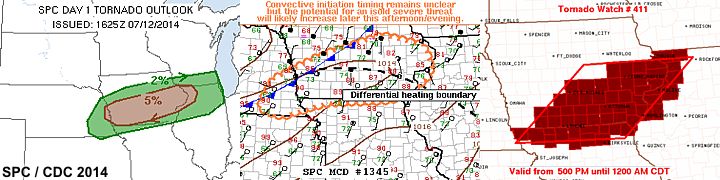
In the image above, we see the outlook and watch areas for the targets involved on this chase. As per the Storm Predictions Center (SPC), there was a slight risk in place from western Iowa across northern Illinois. This constituted a 5% tornado, 15% hail. and 30% wind probabilities. The middle image is one of the mesoscale discussions (MCD 1345) showing the position of a differential heating boundary and weak cold front over the most promising area extending from west-central Iowa into western Illinois as well as subsequent tornado watch box 411 issued at 5 PM CST valid until 12 AM the next day.
STORM RADAR IMAGERY - JULY 12
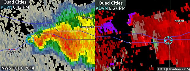
Two radar images above show the base reflectivity (left) and velocity (right) of the supercell storm as it was passing southeast of Morrison, Illinois. This was during the most organized and dramatic phase of this near-tornado producing storm. The classic hook is forming in the reflectivity image to the left, with at least two mesocyclones apparent with the storm a couple scans later and a couple miles east in the right velocity image.
DETAILED CHASE LOG FOR JULY 12, 2014
1). July 6, 6:00 PM - Interception and penetration of a very severe and tornadic thunderstorm from near Dewitt in Clinton County, Iowa and eastward along Highway 30 to near Rock Falls, Illinois in Whiteside County and near I-88. The storm was a supercell storm that initiated west of Clinton County during the mid afternoon. The storm intensified quickly and moved due east, passing Dewitt and crossing the Mississippi River into Illinois by early evening. The storm intensified again near Rock Springs, IL and developed strong rotation (possibly a brief tornado as well). The storm core was penetrated near De Witt and 70 (to possibly 80) MPH wind gusts were observed with zero visibility in torrential rain and small hail to dime sized. A rotating wall cloud was also observed at this time. The storm moved east and another rapidly rotating wall cloud was noted near Rock Springs, Illinois. This cycle of the storm was very impressive, and the supercell had a striking "stacked plates" appearance with a low rotating wall cloud / funnels. This possibly had a weak ground circulation as well. The storm weakened after that and evolved into a line segment. A guest (Jeffrey Lam) who was visiting also was in my vehicle on this chase. Some tree damage was observed with this storm, along with flooding. Frequent lightning was also observed, with some close hits. The storms were caused by surface heading, a differential heating boundary, low pressure area, and upper trough. Documentation was HD video and digital stills. A 2013 Ford Fiesta was used to chase the storms. A tornado watch was also in effect for the area until 12 AM CDT.
This concludes the chase log for the central US chase trip for July 12, 2014. The summary includes a total of 1 severe thunderstorm and 1 possible weak tornado. The main chase vehicle conducting this chase was a 2013 Ford Fiesta. This information was prepared exclusively for the National Weather service and the team of Skywarn storm spotters.
GALLERY FOR JULY 12, 2014
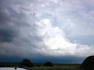
|
Developing supercell storm north of Davenport, Iowa during the afternoon of July 12, 2014 looking southeastward from south of Highway 30 and near Dixon. |
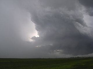
|
Interesting view of the vault and bounded weak echo region on the northeastern side of the supercell storm as it was crossing the Mississippi river south of Clinton, Iowa and into Illinois west of Morrisin. The view is to the southeast with the main updraft and mesocyclone to the right. |
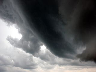
|
Intense banding on the eastern side of the supercell storm southeast of Morrison, Illinois from near Highway 30 and Interstate 88. The storm was at its most intense point here, and very close to tornado genesis. |
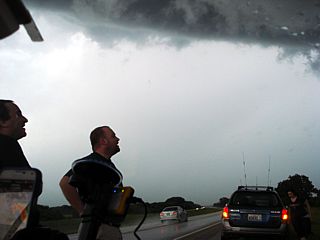
|
Myself (left) and meteorologist / storm chaser Tony Laubach watching the storm organize near Interstate 88 and southeast of Morrison, Illinois and approaching Rock Falls. |
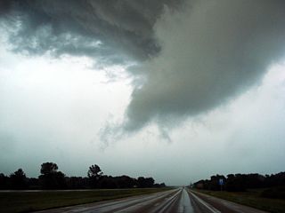
|
Possible brief tornado (or at least an intense mesocyclone) south of Rock Falls, Illinois at about 6:50 PM CDT. This area was rotating vigerously. |
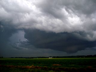
|
The same supercell storm cycles one more time and dissapates south of Highway 30 and near Amboy, Illinois at dusk. This produced one more weak funnel and impressive structure before its final occlusion and evolution to a severe line segment. |
OTHER CHASES IN 2014 IN THE MIDWEST
This section is for any other chases and / or storm pictures taken in the central United States / Midwestern areas during 2014. These include any chases or observations of storms that were local chases (particularly to the Chicago area), but not part of a dedicated chase trip.
DETAILED CHASE LOG FOR THIS SECTION (OTHER CHASES)
1). May 12, 6:00 PM - Observation and indirect penetration of a severe thunderstorm near Highways 20 and 53 and points eastward from near Aurora, Illinois to western portions of Chicago in Cook County. The storm was a multicell severe thunderstorm that evolved briefly to a supercell storm. The storm had a well-developed rain-free base and rotating wall cloud with small funnels while southeast of O' Hare International Airport. The storm core was indirectly penetrated, and heavy rains, 50 to 60 MPH winds, small hail, and frequent lightning with some close hits was observed. The main core of the storm had hail to quarter sized. Conditions causing the storm were surface heating, an upper trough, and a low pressure trough. Documentation was digital HD video. A 2009 Ford Escape was used to chase the storms. A severe thunderstorm watch was also in effect for the area, valid until 11 PM CDT.
This concludes the chase log for the central United States and Midwest (including tornado alley / Illinois) ANY OTHER chases in 2014 not part of a special section. The summary includes a total of 1 severe thunderstorm. The main chase vehicle conducting this chase was a 2009 Ford Escape. This information was prepared exclusively for the National Weather service and the team of Skywarn storm spotters.
GALLERY FOR THIS SECTION (OTHER CHASES)
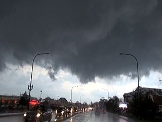
|
This is a rain-free base and slowly rotating region of a supercell thunderstorm crossing over Cook County (near western portions of Chicago), Illinois on May 12, 2014. This storm produced 60 MPH winds, torrential rains, and hail to quarter sized. The view is to the east. |
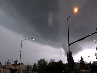
|
Here is another picture, looking to the northeast, of the severe thunderstorm moving across western portions of Chicago, IL on May 12, 2014. Note the striations to the left side of the image, with intense forward-flank precipitation core and UDI (updraft-downdraft interface). The wall cloud is just behind the traffic light / pole to the lower-right side of the picture. |
HTML File "mwcl2014.htm" - Developed By Chris Collura
To Return To The HOME Page Of This Site Click The "INDEX.HTM" Link Here!