
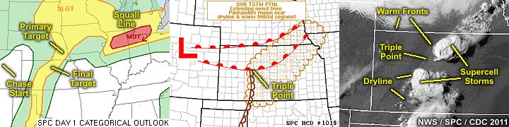
| This section is for storm chases done in the central / Midwestern United States during the year of 2011. This includes all storm chasing activities (including any major chase "expeditions") during the year of 2011 in the central USA (aka "Tornado Alley"). For 2011, all chases in the central USA will be logged in this section, with many of the chases being possible "spot" chases / major severe weather "setups" chased. Here you should find many pictures of lightning, tornadoes, hail, strong winds, along with many severe thunderstorm elements. Keep in mind that this chase log is scientific evidence and portrays my on-going storm chasing research. It has been placed on this page for easy reference and meteorological interests. Please do not plagiarize or copy this document to other sites for distribution. Note - This page may take a while to load on some SLOWER connections! |
STORM CHASING - CENTRAL UNITED STATES - SPECIAL 2011 CHASE LOG
| CHASER NAME | HOME CITY | CALLSIGN | CHASE DATES | OCCUPATION |
| CHRIS COLLURA | MIAMI, FL | KG4PJN | 4-23 TO 4-25 | IT CONSULTANT |
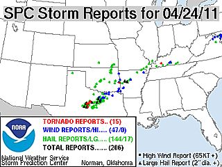
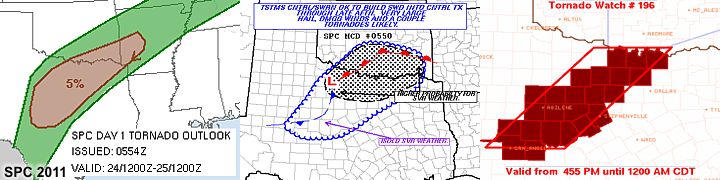
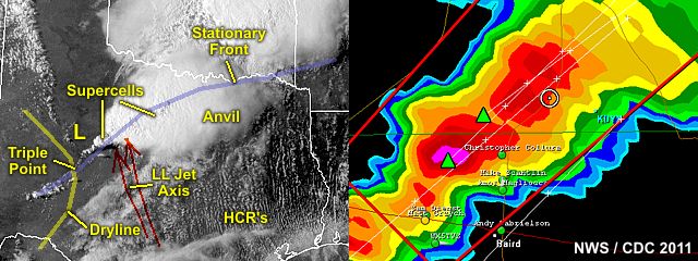
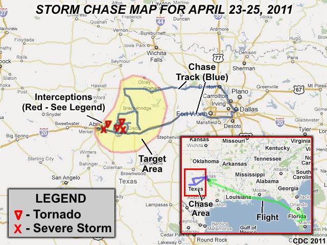
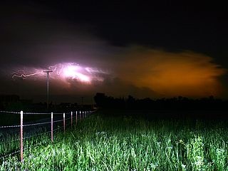
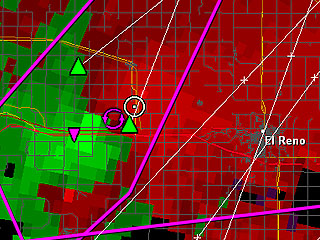
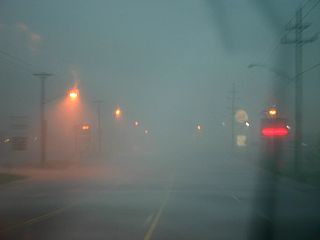
1). April 24, 4:00 PM - Interception of an extremely severe and tornadic thunderstorm near Baird and along Highway 283 and about 5 miles north of Interstate 20 in Callahan County, Texas. The storm was a classic / HP supercell tornadic storm moving northeast from near Abilene, Texas to near Moran. At least two tornadoes were observed with this storm. The first was a stove pipe / elephant trunk tornado observed at close range (less than 1 mile) from along Highway 283. This tornado lasted roughly 5 minutes, and weakened before hitting any roadways. The second tornado was from the left-split of the same supercell as it evolved to HP mode, and was basically a very large rotating mass / wall cloud observed near the intersection of 283 and farm road 576. The tornadoes occurred over open / rural country and did not affect any populated areas. The core of the supercell, with possible hail to 4" (grapefruit sized) was not penetrated, however, 70+ MPH winds (mainly RFD), hail to 1", torrential sheets of rain, and extremely frequent lightning with numerous close hits was encountered. The storm continued northeast towards Moran producing additional funnel clouds. The storms were caused by a stationary front, developing dryline, strong wind shear (strong winds aloft), surface heating, and a low pressure trough (surface low and trough aloft). A 2011 Hyundai Elantra was used to chase4 the storms. Documentation was still digital photos and HD video. A tornado watch was also in effect for the area until 12 AM CDT.
2). April 24, 6:00 PM - Interception of a very severe and tornadic thunderstorm northeast of Abilene and north of Interstate 20 (Clyde) in Callahan County, Texas. The storm was an intense tornadic HP supercell moving northeast from near Abilene and over open country. Another tornado was observed with this storm, with a rapidly rotating wall cloud and later a broad area of rotation with smaller vortices briefly touching the ground on the eastern flank of the storm. The core of the supercell, with at least baseball sized hail (2.5+") was not penetrated. Winds near 65 MPH, hail to 1", heavy rain, and frequent lightning was also observed with this storm. The storms were caused by a stationary front, developing dryline, strong wind shear (strong winds aloft), surface heating, and a low pressure trough (surface low and trough aloft). A 2011 Hyundai Elantra was used to chase4 the storms. Documentation was still digital photos and HD video. A tornado watch was also in effect for the area until 12 AM CDT.
This concludes the Chase Log for the southern US Plains and Midwest tornado chase trip from April 23 through April 25, 2011. The summary includes a total of 2 severe thunderstorms and at least 3 tornadoes. The main chase vehicle conducting all chases was a 2011 Hyundai Elantra. This information was prepared exclusively for the National Weather service and the team of Skywarn storm spotters.
|
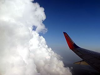
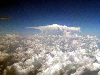
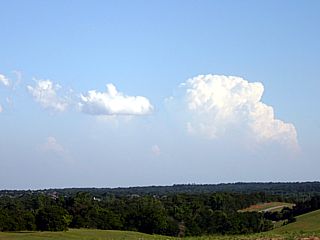
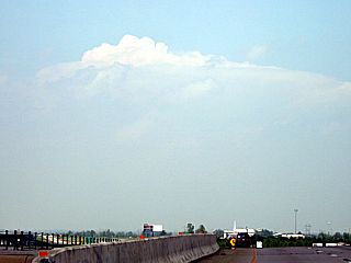
Beautiful towering cumulus clouds high over the Louisiana marshlands while descending into New Orleans, Louisiana for a stop-over while flying from Fort Lauderdale, Florida to Dallas, Texas. |

|
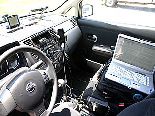
Here is the chase vehicle, a 2011 Hyundai Elantra rental, setup and ready to chase during the morning of April 24, 2011. The suction cup mount is velcro and allows my wireless internet and GPS to be mounted in a neat fashion. |
|
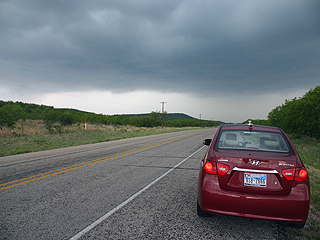
Here is a picture of my vehicle along Highway 283 waiting for the supercell to intensify and become tornadic in Callahan County, Texas. The view is to the north. |
|
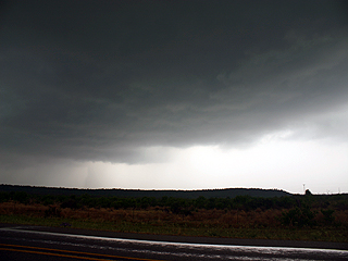
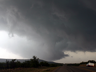
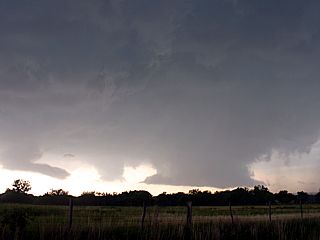
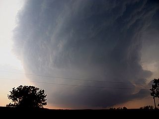
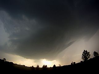
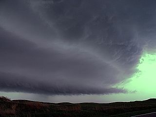
The rain free base and developing mesocyclone becomes ominous by 3:30 PM CDT north of Baird, Texas looking WSW from Highway 183 in Callahan County. The developing supercell and mesocyclone is denoted by the small clear notch in the rain-free base in the center of the picture just above the mesa. |

|
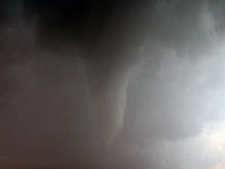
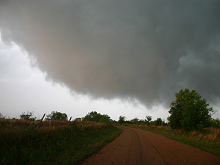
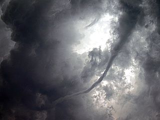
Large and strongly rotating wall cloud / funnels looking southwest along Highway 283 about 5 miles north of Baird, Texas at about 3:45 CDT. |
|
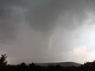
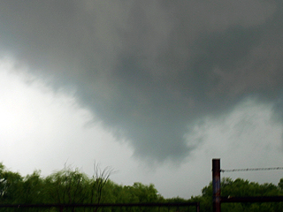
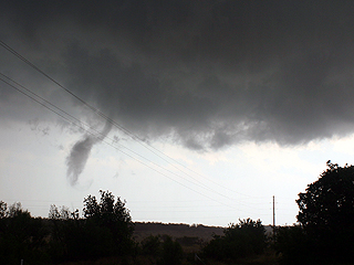
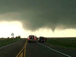
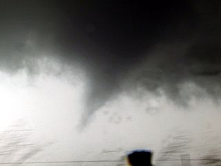
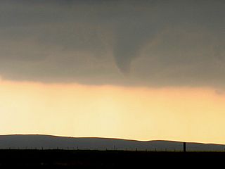
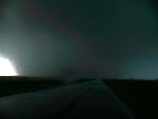
Developing tornado less than a mile to my SW and looking SW from a few miles north of Baird, Texas in Callahan County on highway 283. |
|
Same tornado still moving towards me, looking SW from along Highway 283 north of Baird, Texas. Tornado is about a half mile to my SW, and you were able to hear a slight roar from it. |
|
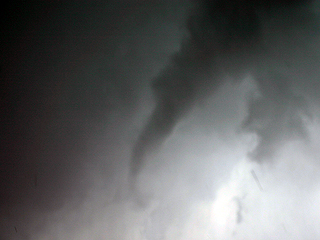
Tornado roping out just prior to 4 PM CDT while looking SW from Highway 283 north of Baird, Texas. The tornado lifted before hitting the roadway. |
|
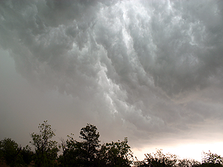
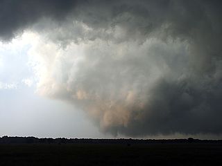
Large rotating wall cloud and possible multi-vortex tornado developing to the northwest of the first tornado (possibly a stronger left split of the supercell storm). This area was northwest of the intersection of Highway 283 and farm road 576. Rapid motion and very strong RFD here (note the clear slot to the left)! |
|
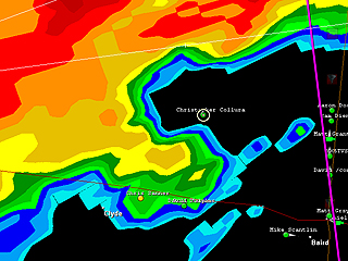
Not a good place to be according to GRLevel3 radar! Well if you are a storm chaser, in the "bear's cage" is the place to be! |
|
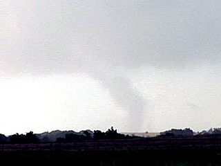
Second developing tornado north of Clyde, Texas from a second supercell storm northeast of Abilene and north of Interstate 20 by roughly 6 PM CDT. The view is to the NW. |
|
Tornado continues to my north and northeast while on a farm road north of Clyde, Texas. |
|
Another radar image from GRLevel3 showing me in the inflow "notch" and near the hook of the supercell radar reflectivity. This about the same time the pictures above and below were taken. |
|
Weakening but still rotating tornado with interesting vortex "thread" to its left, while north of Clyde, Texas. This was looking to the NE and near the forward-flank of the supercell mesocyclone. |
|
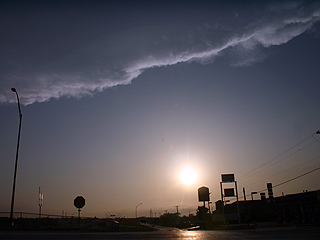
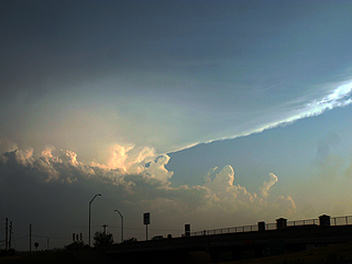
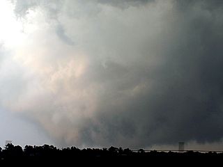
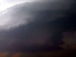
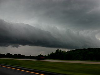
Supercell storm finally "gusts out" and becomes outflow dominant near 7 PM CDT northeast of Abilene. A beautiful "whales mouth" type feature can be seen on the backside of the severe storm gust front. |
|
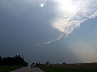
View looking west from Abilene, Texas towards the hazy sunshine in the dry air behind the severe storms. The dryline is clearly visible making its way eastward with an impressive back-sheared anvil impinging on the top of the picture. |
|
View looking to the south of Abilene, Texas at the "tail-end Charley" supercell storm. Additional tornadoes and hail to grapefruit sized (4") was being produced by this storm. |
|
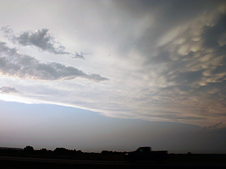
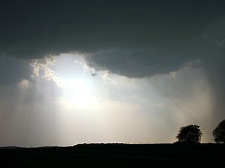
Sunset and mammatus clouds seen from east of Baird, Texas as the sun sets. |

|
Who says the "devil's number" is bad luck ... I noticed I had that number all along on my license plate of my rental chase vehicle as I was packing up and leaving for the airport to go back to Florida. The "666" on the plate had me laughing, maybe the "bad luck" it was supposed to bring was just BAD WEATHER to chase! |
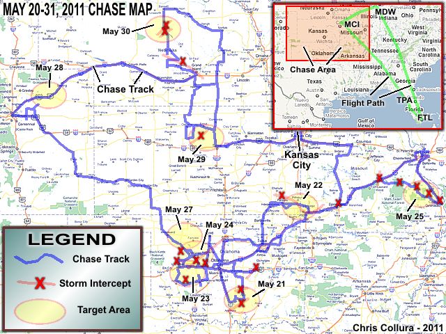
May 20 - This was a travel day with a flight from Fort Lauderdale, FL to Kansas City, MO with a stop-over in Tampa. The arrival into Kansas City was delayed a bit, and after arriving I picked up the rental vehicle and set it up with equipment off the airport. Anticipating an un-determined target the next day, I headed east on Interstate-70 and spent the night in Booneville, MO.
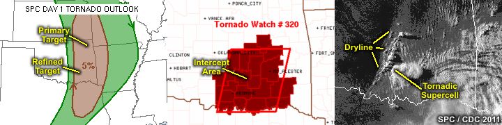
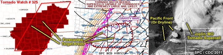
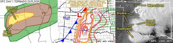
May 21 - May 21 began with forecasting and leaving Booneville, MO early with a primary distant target as Tulsa, OK. The best route to Tulsa was to drop south and southwest on Highways 153 and 54 to Highway 71, then west and southwest on Interstate 44 into Oklahoma. I arrived at Tulsa, OK in time for lunch and looking at data. The SPC had a large slight-risk area, extending from eastern Nebraska and south to central Texas. Wind and hail probabilities were set at 15% and 30% (hatched for hail), respectively. The highest tornado probabilities of 5%, extended from Texas into Oklahoma near Tulsa. It became apparent that there was a lot of capping (convective inhibition) and a very inactive dryline was noted with a line of cumulus well east of Oklahoma City. I headed south out of Tulsa on highway 75, then west along Highway 48 until near I-35 near Wellston. I was ready to call the day a "cap bust" when a distant cell was noted along the dryline to the SE. I headed south quickly through Oklahoma City and caught up with the supercell storm near Sulphur, OK along and near Highway 7. By this time (7 PM or so), the SPC placed tornado watch 320 in the area of south-central OK. The supercell storm produced at least 4 tornadoes! After intercepting the first storm, another storm was noted near Ada while heading along Highway 48, also producing tornadoes, one of which was noted from a distance. The chase was wrapped up by heading northwest on 3W / Highway 177 to Interstate 40, then west into Oklahoma City for the night.
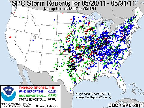
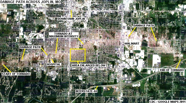
May 22 - Today was a chase day with the interception of an extremely violent tornadic supercell near Joplin, MO. The chase began in Oklahoma City after forecasting a primary target of near the OK / KS / MO borders. I headed up I-44 to Tulsa and checked data there. SPC had a moderate risk outlook in place, with a 10-15% hatched tornado outlook, 15% damaging wind, and a 45% hatched hail for probabilities. By early afternoon, mesoscale discussion #853 and subsequent tornado watch box 325 for the targeted area. Out of Tulsa, I headed north on Highway 169 to intercept a developing storm targeted near Parsons, KS and near and south of Highway 400. I basically followed this supercell storm from initiation near 4 PM and well to the southeast along highways 160 / 69 and then 96 into Missouri and eventually I-44 until it evolved into a line segment. Large hail and the violent winds of the backside of a destructive tornado / RFD were encountered north of Joplin and near Carthage. The chase of this storm was wrapped up near Chesapeake with a return west along Highway 60 and 39 back to I-44 for a brief damage survey near Joplin. I-44 was closed, with trucks and vehicles overturned, as well as EXTREME damage to Joplin (with numerous fatalities). The road closured forced a southward track out of Se Joplin and south along Highway 175 to 60, then west all the way to Bartlesville, OK for the evening.
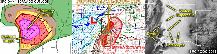
May 23 - May 23 was a moderate risk chase day with the interception of a very intense supercell in SW Oklahoma. The chase began by leaving Bartlesville, OK after forecasting a primary target area from near Enid southward to Cordell. I headed west on Highway 60 to I-35, then south to Highway 64 and west to Enid. After easting and looking at more data, it became apparent that SW Oklahoma (near I-40 and Highway 183) would be the best place for discrete supercells. I headed out of Enid via Highway 60 and 18, south through Watonga, then SW on Highway 33 to Highway 183. Meanwhile, the storm prediction center had a moderate risk outlook, with a 10% tornado, 15% wind, and 45% hatched hail probabilities. Mesoscale discussion #896 and subsequent tornado watch box 345 was also issued for this target area. The first storms were encountered near the intersection of Highway 33 and 183. Later on, farther south, another supercell with extremely destructive hail was intercepted SE of Cordell near Highways 9, 115, and 9. This supercell produced hail around 6 inches in diameter, setting a new state record hail-size for Oklahoma! The chase was wrapped up after hail damaged the vehicle (including a cracked windshield). I headed east on Highway 62, then north on Highway 81 to I-40, then back into Oklahoma City for the night.
May 24 - Today was a high risk chase day, which began with forecasting and leaving Oklahoma City for a primary / tentative target of Enid, OK by heading up Highways 3 and 81. SPC had a high risk for a large portion of Oklahoma, with probabilities denoting a 30% hatched tornado, 30-45% wind, and a 45% hatched hail threat. After lunch, it was determined the best storm chanced / initiation may take place farther southwest in the areas near Highway 183 and I-40. A call was made to head back south on Highway 81 to Kingfisher then west on Highway 33 then south to near Calumet along N2740 to 270, and eventually west to near Weatherford along I-40. During this time, SPC issued Mesoscale Discussion #925 and subsequent PDS (Particularly Dangerous Situation) tornado watch box 356 for the area. Initiation also was taking place in the aforementioned area west of Highway 183. The first cluster of supercells was encountered in the area near Putnam and Arapaho near highways 33 and 270. Attempting to remain ahead of the storms, I opted to take 33 and 270 through Watonga then southeast to near Calumet. A supercell / wall cloud was encountered south of Watonga, then an extremely violent supercell near Calumet, with a rain wrapped tornado in near total darkness passing less than a mile south of me just north of I-40 on 270 (with an audible roar)! The chase then turned east on I-40 with damage observed and a loud roaring sound from a damaged refinery. I headed north again on Banner road out of El Reno and encountered the damage path north of Hefner road. This tornado was entirely rain wrapped. I then reached highway 3 and headed southeast through Piedmont, where more extensive damage was observed. I continued to John Kilpatrick Turnpike to divert north around Oklahoma city, then north on I-35 to reach the same supercell in Guthrie. I bailed on the intercept because the storm had a tornado that was too rain wrapped. I headed back south on I-35 to I-40 east, intercepting another supercell near Tinker AFB and noted debris (including sheet metal) falling from the sky! I headed south on Sooner road and to the I-240 exit for a fuel stop, but the tornadic storm there became outflow dominant. I headed east on I-240 then I-40 where I ran into Bill Hark and intercepted a very impressive stovepipe / rope tornado just northwest of Shawnee. This tornado mangled a semi-trailer and injured the driver, so I stopped to assist. After, I continued back west on I-40, then to I-35 and I-44 to stay again in Oklahoma City for the night.
May 25 - Today was a very "long-shot" chase day with a long drive to the high-risk area in eastern Missouri from Oklahoma, and ultimately catching numerous severe storms and at least one tornado. After a quick forecast, I left Oklahoma City at about 8:30 AM and headed up I-44 making Tulsa, OK by about 10:30 AM. More forecasting on the road revealed a target area 50 to 100 miles to the south and east of Saint Louis, MO. Meanwhile, SPC had a large high-risk area, with 30% hatched tornado, 30% wind, and 45% hatched hail probabilities. I continued northeast along I-44, with a quick diversion at about 11:30 AM into Joplin to survey some of the May 22 devastation there. While continuing NE through a developing severe storm near Springfield, SPC posted mesoscale discussion #952 and subsequent tornado watch boxes 369 and PDS (particularly dangerous situation) 370 including my target area. Clusters of severe storms and supercells began developing from east-central MO to the eastern portion of the state. The first tornado-warned supercell was encountered near Rolla, MO. The chase continued to the NE along I-44 to Cuba, MO then south on Highway 19 through Steelville with another HP supercell storm encountered. I headed east on Highway 8 through Potosi to near Desloge and south on Highway 67. The first significant supercell of the day was encountered north of Fredricktown, MO and a brief tornado was observed with this storm. Some tree damage was noted in Fredricktown. I headed east on Highway 72, encountering two more severe storms near Patton and Millersville. I finished the chase by heading north on I-55 near Cape Girardeau and spend the night in Saint Louis, MO.
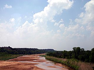
May 26 - May 26 was an off day with a long reposition back to Oklahoma after spending the night in Saint Louis, MO. I was able to see the Gateway Arch tram as well as the extremely high water of the Mississippi River during the morning. I left Saint Louis and stopped for lunch near Creve Coure and then headed back to I-44 for the long trip back to Oklahoma City. I stopped again in Joplin, MO to take more footage of the devastation, as well as donate some food and water I didn't need. I arrived back in Oklahoma City at about 9:30 PM, anticipating a possible chase day near that area the next day (May 27).
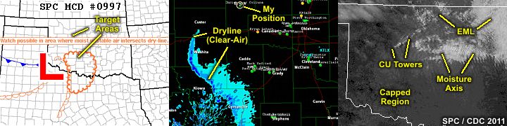
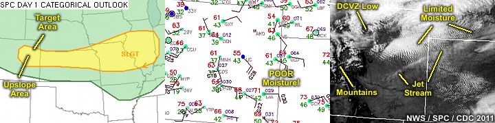
May 27 - Today was a very marginal chase day, but ended up as a classic "cap bust". I forecasted and left Oklahoma City around lunch time, initially choosing the area from near I-35 to Enid (shear axis and instability seemed good there). I headed up I-35 to Perry for lunch. SPC had a small area of slight risk from NE Oklahoma and southwest to SW Oklahoma. Tornado probabilities were set at only 2%, with a 15% hail and 5% wind probability. As the day went on, it appeared the area of interest would be farther southwest to near I-40 and west of Oklahoma City due to very high CAPE (instability) in that area. I headed west on Highway 164 out of Perry and south on Highway 81, then west on 51 to Okeene to check data. SPC issued Mesoscale Discussion #997 for the area in SW Oklahoma, with a weak surface low and dryline present - Albeit no clouds. I creeped south a bit on Highway 8 to Watonga and waited there for a few hours. The dryline / low remained inactive due to the very strong capping inversion. Some cumulus developed to my north, so I headed back up Highway 8 in that direction. The cap was still too strong, and the convection dissipated near Hitchcock just before sunset. I was aware a "cap bust" was in progress, and got nothing but a suntan. I ended the day by heading northeast to Canton, then west on Highway 51 to Highway 270 (then 183) towards Woodward. I was stopped by law enforcement near Mutual for speeding down a hill (75 in 65) and had my car searched (I was told of a BIG problem with meth in that area), but the friendly officer let me off with a verbal warning. I continued to Woodward, then north on Highway 183, then highway 34 to 400 and into Dodge City for the night. And, as luck would have it, I was pulled over AGAIN, this time for failing to turn signal pulling into the motel - And AGAIN, like before - The friendly officer just warned me verbally and gave me directions to the motel! At least I should be in a good position for May 28's slight risk in the high plains?
May 28 - Today was another highly conditional chase day with low hopes ending up with a bust in NE Colorado. I forecasted and found two areas, one in Missouri and the other in NE Colorado, the latter being a half days drive and easily reachable. SPC had a slight risk extending from NE Colorado, across N Kansas, and into Missouri towards Illinois. The tornado probabilities ranged from a measly 2% in NE Colorado to 5% in Missouri, along with 5% wind and 15% hail probabilities. Upslope flow and lee cyclogenesis were encouraging factors in choosing NE Colorado as the target. All in all, no good storms developed in either regions (Colorado nor Missouri). The eastern regions remained capped, and the Colorado target was trumped by cool temperatures and lack of moisture return. I left Dodge City, KS and headed west into Colorado on Highways 50 then north on 287 out of Lamar. I then took Highway 40 west and northwest to near I-70 near Limon, then west on I-70 to Byers. I waited for some time and it seemed like clouds were not getting very organized, despite a strong Denver Cyclone / DCVZ in the afternoon. I hung out anywhere east of Denver International airport in open country near Highway 79 (Bennett and Prospect Valley) and only light showers developed with cool temperatures. Once again, a long drive ended up empty handed. I headed west on I-70, spending the night in the east side of Denver near Aurora.
May 29 - May 29 involved a very long drive to get into position for more activity farther east for the last couple of days of chasing for this trip. In addition to a long drive from Denver, Colorado to SE Nebraska / NE Kansas, a marginal setup existed for severe weather in the target area, with a slight risk issued by the SPC, with a 2% tornado, a 5% damaging wind, and 15% hail probability. I forecasted and found the best place to be in early evening was SE Nebraska / NE Kansas with a potential dryline / warm front interaction there, along with decent upper-air support. I left Denver, CO rather early, heading out on I-76, then I-80 into Nebraska all the way east until near York. I then headed south on Highway 81, while trying to troubleshoot some frustrating data issues. I saw a cell firing in NE Kansas south of Beloit, about 75 miles to my SW, so I continued down Highway 81 to Highway 9 out of Concordia, then west towards Glenn Elder and Highway 24. SPC also issued Mesoscale Discussion #1018 and subsequent severe thunderstorm watch box 396. I headed south on Highway 181, intercepting a nice LP supercell northwest of Tipton. After the intercept, I headed back north on Tipton Road to Highway 24, then north on Highway 181 / 78 into Kansas to Highway 4, then east to Highway 81, then north into York, NE for the night.
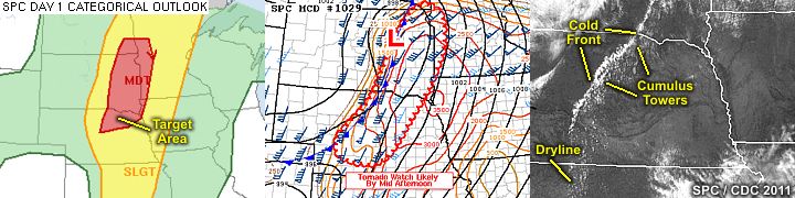
May 30 - This was the last chase day of this trip, and was a moderate risk chase day in north-central Nebraska. With morning forecasting in York, NE it appeared the setup was such that initial storms would produce tornadoes, but then transition quickly into a squall line / derecho by evening. The SPC had a moderate risk out for the area in north-central Nebraska stretching into SE South Dakota. Initially, the tornado probabilities were set at 15% hatched, but later dropped to 10% (not hatched) on the 1630z outlook. The hail and wind probabilities were kept at 30% hatched and 45% hatched, respectively. I left York and headed north on Highway 81 into Norfolk, then west on Highway 275 to Oniel, waiting on more data and finalizing the target areas for initiation, which now appeared to be more towards north central Nebraska instead of far SE South Dakota. There was also quite a number of other storm chasers congregating in Oniel. The SPC then issued Mesoscale Discussion #1029 and subsequent tornado watch box 402 for the area. Storm initiation began southwest of Oniel by about 3:30 PM, and a chase track west on Highway 275 to near Bassett, then south on Highway 183 was executed. The cold front was encountered near Bassett, so a trip south on 183 was necessary for a large severe storm northeast of Brewster. This storm was encountered, and caused extensive damage to the chase vehicle (windshield smashed and numerous dents from baseball hail). A developing tornado was observed with this storm. Additional storms also developed as the evolution to a squall line commenced. I hung around Highway 183 near Rose, meeting up with many other chasers, including Scott Mc Partland, Bill Hark, Mark Robinson, and others. The chase continued south after that, I tool Highway 96 to Burwell then west on Highway 91 to continue back south on Highway 183. I bailed going south on another intense storm near Ansley, and got off 183 and took Highway 2 all the way to Grand Island, then south on Highway 281 to Highway 36 east, then continued south on Highway 81 into Kansas and to near I-70, spending the last night in Salina.
May 31 - This was the travel and departure day. I packed up early in Salina and arranged insurance paperwork for the damage to the rental vehicle, which was returned in Kansas City. I Flew out of Kansas City International back to Fort Lauderdale, Florida (connecting in Chicago, Illinois). This concludes this exciting (and tragic) chase trip in 2011. Total mileage on the vehicle was about 5934 miles.
| CHASER NAME | HOME CITY | CALLSIGN | CHASE DATES | OCCUPATION |
| CHRIS COLLURA | MIAMI, FL | KG4PJN | 5-20 TO 5-31 | IT CONSULTANT |
1). May 21, 7:30 PM - Interception and observation of an extremely severe and tornadic thunderstorm in Murray and Ponotoc Counties, OK and northeast of Sulphur along Highways 7 and 1. The storm was a classic tornadic supercell thunderstorm, with a very impressive structure. At least 4 tornadoes were observed with this storm, ranging from rope to small stovepipe and eventually multi-vortex. The storm core, with hail to baseball sized, was not penetrated. No damage was found because the tornadoes affected very remote / rural areas. Other conditions encountered were winds gusting near 70-MPH (mainly RFD), heavy rains, occasional lightning, and some hail to golfball-sized. The storm was caused by a low pressure trough, wind shear (strong winds aloft changing direction with height), surface heating, and a dryline boundary ahead of a weak low pressure system. A 2010 Nissan Versa was used to chase the storm. Documentation was HD video and digital still pictures. A tornado watch was also in effect for the area until 12 AM CDT.
2). May 21, 9:30 PM - Observation of another extremely severe and tornadic thunderstorm northwest of Ada in Ponotoc County, OK from near Highway 377. The storm was mainly observed from a distance (20 miles or so) with a very impressive storm structure (striated and tilted updraft). Closer to the storm, a large cone tornado was observed on the rear-flank side of the supercell from southeast of Ada, at a distance of about 10 miles in twilight. North of Ada, hail to 2" was observed on the edge of the storm core, causing the chase to be aborted and leaving two dents in the top of the vehicle. Other conditions observed were frequent lightning (the core was not directly penetrated) and 35 MPH winds. The storm was caused by a low pressure trough, wind shear (strong winds aloft changing direction with height), surface heating, and a dryline boundary ahead of a weak low pressure system. A 2010 Nissan Versa was used to chase the storm. Documentation was HD video and digital still pictures. A tornado watch was also in effect for the area until 12 AM CDT.
3). May 22, 6:00 PM - Penetration and observation of an extremely violent and tornadic thunderstorm from near Parsons, Kansas in Labette County near Highways 59 and 160 and well to the southeast through Jasper County north of Joplin along Highway 96 and eastward along Interstate 44 through Chesapeake. This storm was a long track and violent HP supercell storm. The core of the storm was indirectly penetrated southeast of Parsons, KS and hail to golfball sized was observed. The core had hail up to grapefruit sized. The same storm split and the right split became extremely intense, causing a violent (EF-5) tornado to affect Joplin, Missouri. The tornado was not directly observed, as the storm was approached from the backside, but the circulation was viewed briefly when it was west of Joplin. Debris was noted falling from the sky with 70+ MPH winds, golfball sized hail, and torrential rains with frequent lightning. Damage in Joplin was very severe, including a destroyed hospital, numerous vehicles overturned, and many fatalities (at least 160 people killed). The storm was caused by a low pressure system, surface heating, a dryline boundary, and very strong wind shear in the atmosphere / jet stream aloft. A 2010 Nissan Versa was used to chase the storms. Documentation was HD video and digital still pictures. A tornado watch was also in effect for the area until 9 PM CDT.
4). May 23, 3:30 PM - Observation of a developing severe thunderstorm near the intersection of Highway 183 and Highway 33 north of Arapaho in Custer County, Oklahoma. The storm was an LP supercell storm and some funnel clouds (one ropelike and nearly a third way to the ground). Frequent lightning with a couple of close hits was also observed, but the storm core was not penetrated. The storm merged with a line of storms, so it was abandoned for more discrete supercells to the south (although this storm did eventually wind up producing a couple of small tornadoes). The storm was caused by a low pressure trough, wind shear, surface heating, and a dryline boundary ahead of a weak low pressure system. A 2010 Nissan Versa was used to chase the storm. Documentation was HD video and digital still pictures. A tornado watch was also in effect for the area until 10 PM CDT.
5). May 23, 6:00 PM - Observation and indirect penetration of an extremely severe thunderstorm east of Highway 183 and near Highways 9 and 115 in Washita County, Oklahoma and near and southeast of the town of Gotebo. The storm was a classic supercell storm, with an extremely striking visual (stacked-plates) appearance. Hail up to 4" was observed with this storm, despite INDIRECTLY penetrating its core, which had hail even larger (the storm produced hail around 6 inches in diameter, and was confirmed as a new state record hail-size for Oklahoma)! The storm also had frequent lightning with close hits, inflow winds measured at least 40 MPH, heavy rains, and stronger winds in the core. A funnel cloud was also observed on the SW side of the supercell updraft. The storm later weakened near Carnegie and became outflow dominant. Hail damage was the most obvious affects of this storm, and my vehicle was not an exception (numerous roof dents and a cracked windshield from near baseball sized hail falling from the storm anvil). The storm was caused by a low pressure trough, wind shear, surface heating, and a dryline boundary ahead of a weak low pressure system. A 2010 Nissan Versa was used to chase the storm. Documentation was HD video and digital still pictures. A tornado watch was also in effect for the area until 10 PM CDT.
6). May 24, 4:00 PM - Interception and observation of a very severe, and possibly tornadic thunderstorm southwest of Watonga, Oklahoma in Blaine County from near Highway 270. The storm was an HP supercell storm, with a large rotating wall cloud on its southern side. Some small funnels were noted before the storm was abandoned for a more intense one farther south. The core of this storm, containing hail to baseball sized, was not directly penetrated. Conditions encountered were 40 MPH winds, heavy rains, frequent lightning, and hail up to nickel sized. The storm was caused by a strong low pressure system, strong upper trough, speed / directional wind shear, dryline, and surface heating. A 2010 Nissan Versa was used to chase the storm. Documentation was HD video and digital still pictures. A PDS tornado watch was also in effect for the area until 10 PM CDT.
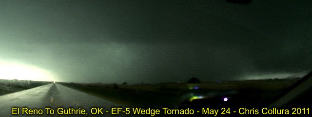
7). May 24, 5:00 PM - Interception and penetration of an extremely severe and violent tornadic thunderstorm south of Calumet, Oklahoma in Canadian County from near Highway 270 and I-40 and points well east and northeast to near I-35 and John Kilpatrick Turnpike and south of Guthrie. The storm was a violent HP supercell storm, which produced a large and destructive long-track rain-wrapped tornado. This tornado was also rated EF-5, with a mile-wide damage path, and a track-length of about 75 miles. At least 9 People were killed by this tornado. The conditions near Calumet included isolated hail up to 2" (or larger), extremely frequent lightning with numerous close hits, torrential rains, and winds gusting over 75 MPH. The storm was extremely dark, and a large rain wrapped wedge tornado was encountered about 1 mile north of I-40 on highway 270. I had to back off and let it pass, after being able to hear the roar from it. This rain wrapped tornado and storm was chased from near this location on and off via various road options until south of Guthrie. Damage was extensive in some areas, along a southwest to northeast path. A loud jet-engine sound of the tornado was noted on I-40 just east of Highway 270 at a distance of 1-2 miles. Other damage was to trees, fences, signs, and severe structural damage to buildings and homes (including roofs torn off and some completely destroyed). The storm was abandoned south of Guthrie because it was rain wrapped and too dangerous to chase. The storm was caused by a strong low pressure system, strong upper trough, speed / directional wind shear, dryline, and surface heating. A 2010 Nissan Versa was used to chase the storm. Documentation was HD video and digital still pictures. A PDS tornado watch was also in effect for the area until 10 PM CDT.
8). May 24, 6:00 PM - Interception and indirect penetration of a very severe and tornadic thunderstorm southwest near and south of Tinker AFB in Oklahoma County from near Sooner road and I-240. The storm was a violent classic (evolving to HP) supercell storm which produced a tornado that damaged buildings near Moore, OK. At my location near the SE side of the Air Force base, extremely frequent lightning with many close hits, heavy rains, 50 MPH winds, and hail to golfball sized was encountered. Debris was also noted falling from the sky, including large pieces of sheet metal! The storm eventually became outflow dominant. The storm was caused by a strong low pressure system, strong upper trough, speed / directional wind shear, dryline, and surface heating. A 2010 Nissan Versa was used to chase the storm. Documentation was HD video and digital still pictures. A PDS tornado watch was also in effect for the area until 10 PM CDT.
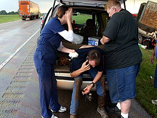
9). May 24, 7:00 PM - Interception and penetration of another very severe and tornadic thunderstorm northwest of Shawnee, Oklahoma along I-40 and near S Harrah road overpass. The storm core had a brief period of 40 MPH winds, nickel sized hail, heavy rains, and occasional lightning. A wall cloud was noted on the south side of the storm, moving rapidly NE. Before the gust front from the previous weakening storm near Tinker AFB had a chance to undercut this supercell, it produced a small but very intense tornado. The tornado quickly formed and lasted about 5 minutes, crossing I-40 and tossed / ripping apart a large semi-trailer (driver was injured but alert as I had to stop and help). Another couple driving was also nearly hit, and one member had to lie in a ditch. Other than tree and sign damage, this tornado was in a rural area. The storm was caused by a strong low pressure system, strong upper trough, speed / directional wind shear, dryline, and surface heating. A 2010 Nissan Versa was used to chase the storm. Documentation was HD video and digital still pictures. A PDS tornado watch was also in effect for the area until 10 PM CDT.
10). May 25, 2:30 PM - Penetration of a strong to severe thunderstorm near Springfield, Missouri in Greene County along I-44. The storm was a portion of a line of strong and severe storms. Conditions encountered with this storm were 40 MPH winds, heavy rain, occasional lightning, and hail up to dime sized. Conditions causing the storms were surface heating, an low pressure trough, wind shear, and a strong upper level low. A 2010 Nissan Versa was used to chase the storm. Documentation was digital stills and HD video. A tornado watch was also valid for the area until 6 PM CDT.
11). May 25, 4:00 PM - Interception and observation of a severe and possibly tornadic thunderstorm near Rolla, Missouri just south of I-44 in Phelps County. The storm was a small HP supercell storm, and a rotating wall cloud with funnels passed over Rolla, with the tornado sirens blaring. Conditions encountered with this storm were 40 MPH winds, heavy rain, occasional lightning, and hail up to dime sized. Conditions causing the storms were surface heating, an low pressure trough, wind shear, and a strong upper level low. A 2010 Nissan Versa was used to chase the storm. Documentation was digital stills and HD video. A tornado watch was also valid for the area until 6 PM CDT.
12). May 25, 4:30 PM - Interception and penetration of a severe and possibly tornadic thunderstorm south of Cuba and north of Steelville along Highway 19 in Crawford County, Missouri. The storm was another small HP supercell storm. Conditions encountered when penetrating this storm were 50 to 60 MPH winds, heavy rain, occasional lightning, and hail up to nickel sized. A rotating wall cloud with small funnels was noted on the updraft side of this storm. Conditions causing the storms were surface heating, an low pressure trough, wind shear, and a strong upper level low. A 2010 Nissan Versa was used to chase the storm. Documentation was digital stills and HD video. A tornado watch was also valid for the area until 6 PM CDT.
13). May 25, 5:30 PM - Interception and penetration of a very severe and tornadic thunderstorm near Fredricktown in Madison County, Missouri near Highways 67 and 72. The storm was a classic supercell and a brief tornado was observed on the southern side of the storm, with a rapidly rotating wall cloud. The tornado caused some tree damage, as well as minor damage to a gas station. Conditions encountered when penetrating the core of this storm were 50 to 60 MPH winds, torrential rain, frequent lightning, and hail up to golfball sized. A rotating wall cloud with small funnels was noted on the updraft side of this storm. Conditions causing the storms were surface heating, an low pressure trough, wind shear, and a strong upper level low. A 2010 Nissan Versa was used to chase the storm. Documentation was digital stills and HD video. A PDS tornado watch was also valid for the area until 9 PM CDT.
14). May 25, 4:30 PM - Interception and penetration of a severe and possibly tornadic thunderstorm in Bollinger County, Missouri along Highway 72 west of Patton. The storm was a small HP supercell storm. Conditions encountered when penetrating this storm were 50 MPH winds, heavy rain, frequent lightning with some close hits, and hail up to nickel sized. A rotating wall cloud with small funnels was noted on the updraft side of this storm. Conditions causing the storms were surface heating, an low pressure trough, wind shear, and a strong upper level low. A 2010 Nissan Versa was used to chase the storm. Documentation was digital stills and HD video. A PDS tornado watch was also valid for the area until 9 PM CDT.
15). May 25, 4:30 PM - Interception and penetration of a severe thunderstorm near Cape Girardeau, Missouri along Highway 72 west I-55. The storm was an intense multicell storm, with winds gusting over 65-MPH, torrential rains, nickel sized hail, and frequent lightning with some close hits. Conditions causing the storms were surface heating, an low pressure trough, wind shear, and a strong upper level low. A 2010 Nissan Versa was used to chase the storm. Documentation was digital stills and HD video. A PDS tornado watch was also valid for the area until 9 PM CDT.
16). May 29, 7:00 PM - Interception and observation of a very severe thunderstorm near Tipton, Kansas in Mitchell County near Highway 128. The storm was a classic / LP supercell storm, with a rather high base but impressive visual appearance. The core of the storm was barely penetrated, and hail up to 2" in diameter was measured with the storm passage. The storm also contained occasional lightning, 30 MPH inflow winds, and heavy rains. Conditions causing the storms were surface heating, an upper trough, weak low pressure, and warm front / dryline interactions. Documentation was digital stills and HD video. A 2010 Nissan Versa was used to chase the storm. A severe thunderstorm watch was also in effect for the area until 11 PM CDT.
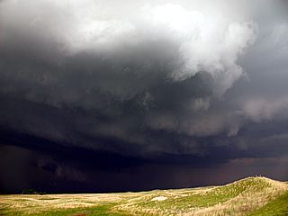
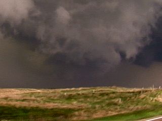
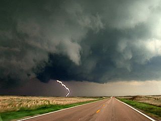
17). May 30, 4:00 PM - Observation and penetration of an extremely severe and tornadic thunderstorm north of Rose, Nebraska along Highway 183 in Rock County. The storm was a very intense HP supercell storm, undergoing transition into a strong bow segment, but still capable of producing tornadoes. A large funnel and wall cloud / tornado was observed in an inflow "notch" of this storm, just before the intense precipitation core slammed the vehicle. Conditions encountered in this storm were 70+ MPH winds, frequent lightning with some close hits, torrential rains, and hail at LEAST baseball sized (3") falling nearly horizontally. The hail shattered the windshield and severely dented all metal on the vehicle, even breaking a windshield wiper and plastic faring below it. Fortunately, the storm remained over mainly remote areas in the Nebraska "Sandhills" region. Conditions causing the storms were a cold front, strong upper trough, and surface heating. Documentation was digital stills and HD video. A 2010 Nissan Versa was used to chase the storm. A severe thunderstorm watch was also in effect for the area until 9 PM CDT.
18). May 30, 5:00 PM - Interception and observation of a very severe thunderstorm near Rose, Nebraska along Highway 183 in Rock County. This storm was another tornado-warned HP supercell that moved over nearly the same area affected by the previous storm. The storm was undercut by outflow, but did have a striated presentation visually as well as a well-defined hail core (green sky)! I did not penetrate the storm core, which had hail to at least 2". Conditions encountered were 60 MPH winds, small hail, heavy rains, and frequent lightning. Conditions causing the storms were a cold front, strong upper trough, and surface heating. Documentation was digital stills and HD video. A 2010 Nissan Versa was used to chase the storm. A severe thunderstorm watch was also in effect for the area until 9 PM CDT.
19). May 30, 7:00 PM - Interception and penetration of another very severe thunderstorm near Ansley, Nebraska along Highway 183 and Highway 2 in Sherman County and many points east and southeast to south of Grand Island, NE in Hamilton County and Highway 281. The storm was a serial derecho (multicell cluster / line of thunderstorms) containing hail up to quarter sized, winds gusting over 80 MPH, torrential rains, and frequent lightning with close hits. The storm caused tree and building damage, as well as knocking out power to many towns. Large gustnadoes were also observed on the leading edge of the gust front. Documentation was digital stills and HD video. A 2010 Nissan Versa was used to chase the storm. A severe thunderstorm watch was also in effect for the area until 9 PM CDT.
This concludes the Midwestern United States Chase Log. The summary includes a total of 19 severe thunderstorms and about 12 tornadoes (or large funnel clouds). The main chase vehicle conducting all chases was a 2010 Nissan Versa. States chased or visited during this trip were CO, KS, IL, MO, NE, and OK. This information was prepared exclusively for the National Weather service and the team of Skywarn storm spotters.
|
Beautiful cumulonimbus / thunderstorm anvil from a distance while flying from Fort Lauderdale to Tampa, FL (connecting through to Kansas City, MO). |
|
Once in Kansas City, the rental chase vehicle (a Nissan Versa) is prepared for at least 10 days of chasing with equipment (HAM radio, Laptop, etc) as well as a roof mounted anemometer / temp-dewpoint sensor and ground-plane HAM / NOAA antenna. Everything is designed to pack up and can be setup without tools. |
|
After a very long drive from east of Kansas City to Tulsa, OK then points southwest of there, a distinct dryline becomes visible marked by a narrow line of clouds across the western sky. An impressive dewpoint gradient was also observed, with a dewpoint in the low 70's ahead of it, and upper 40's just behind it! In this picture, the atmosphere is still capped, and storms are not forming yet. |
|
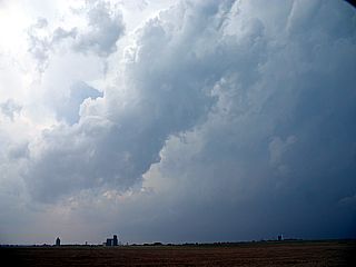
A rapidly developing storm can be seen from near Oklahoma City and looking SE from near I-35. This is developing ahead of the dryline boundary just to my east. The developing storm was currently over I-35 just west of Sulphur, OK ... About 70 miles away. Called a "beacon", storm chasers from miles around will rush towards this first major storm. |
|
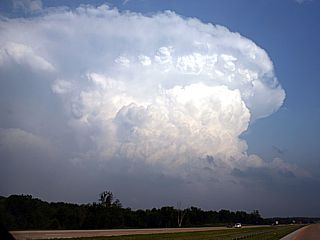
The same storm near Sulphur, OK explosively strengthens into a full-fledged tornadic supercell. In this view, about 15-20 miles away, the storm has an incredibly powerful updraft and back-sheared anvil. |
|
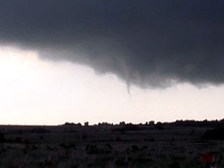
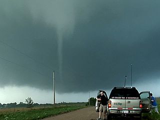
Here is the base of the supercell storm from east of Sulphur, OK at roughly 7:20 PM when the first funnel / small tornado is being produced. |
|
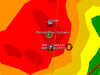
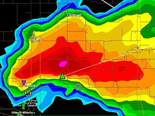
Radar reflectivity image of the storm east of Sulphur, OK. The white circle is my location east of the "bears cage" of the storm. |
|
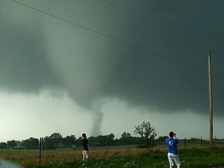
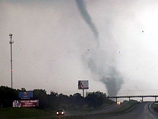
Another view looking northward at roughly 7:30 PM and north of Highway 7. Developing tornado with storm chasers along the roadside. |
|
While nearly directly UNDER a developing tornado, a swirl of spray / dust can be seen a few hundred yards to my southwest! |
|
Same developing tornado now just to my northeast by roughly 300 yards. Time is about 7:35 PM CDT. |
|
Another view of the mature tornado with storm chasers in the foreground. |
|
Heading east, another view of the tornado to my north over my left shoulder. |
|
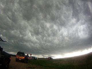
Massive area of rotation with very impressive RFD clear slot. Tornado is on the ground just below the center of the image. The storm is evolving to produce a multi-vortex tornadoes at this point. |
|
Closer view of the large-scale / multi-vortex nature of the tornado. |
|
Still closer, one of several sub-vortices can be seen under the strongly rotating base. |
|
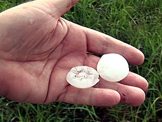
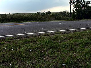
Hail picked up from the side of the road in Ponotoc County. |
|
Here is a view of another violent supercell from a distance of roughly 20 miles. This storm was to the NW of Ada and was also producing tornadoes at the time. I was able to see a large cone tornado from a 10 mile or so distance from near Ada with this storm! |
|
Radar reflectivity image of the storm northwest of Ada, OK. |
|
Convective initiation of a supercell storm viewed from a distance of about 40 miles while en-route to intercept it near Parsons, KS. This was the initiation sequence of the same storm system that will later destroy parts of Joplin, MO with a violent tornado. |
|
Large wall cloud southwest of Parsons, Kansas. |

|
Rotating wall cloud directly over Parsons, Kansas. |

|
This is a view of the right split of the violent supercell storm about 10-15 minutes before it struck Joplin, MO. The rotating area is unmistakable before rapidly becoming rain wrapped. This same mesocyclone would go on to destroy parts of Joplin, MO with a violent mile-wide rain-wrapped tornado. Unfortunately, this storm also killed at least 160 people, the worst EF-5 tornado disaster in about 70 years. |
|
Here is a radar velocity image of the storm as it was near Joplin, MO causing damage. Rather precarious, the white circle is me a couple of miles to the NE in the storm core (probably at the same time I was watching debris raining from the sky). |
|
Interstate 44 closed east of Joplin as it is declared a major disaster area. |
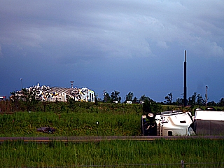
|
Numerous vehicles and semi trucks were overturned on I-44, with devastation on each sides of the interstate. This was not even the main part of the damage path!. |
|
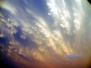
Interesting mammatus cloud formations being stretched by the jet stream winds high over Joplin, MO. |
|
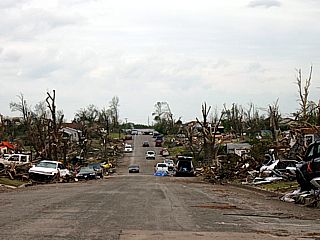
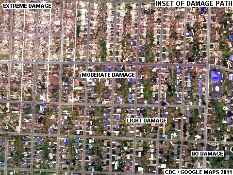
Maxi-tornado EF-5 damage in Joplin, Missouri (picture taken a few days later with permission). Looking down a street of a destroyed neighborhood. |
|
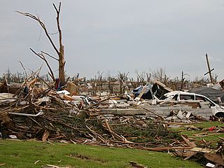
EF-5 tornado damage in Joplin, Missouri (picture taken a few days later with permission). A house once would have filled this picture before the tornado. Note the bark stripped of what is left of the tree to the left! |
|
Time exposure of a distant supercell thunderstorm near Oklahoma City (viewed from east of Bartlesville, OK). Note the light pollution from Oklahoma City illuminating the thunderstorm anvil. |
|
Convective initiation looking west towards the dryline boundary from Highway 183 with the north branch of the Canadian River in the foreground. |
|
Base of first developing LP supercell ahead of the dryline north of Arapaho, OK. Note the subsidence "hole" from a downdraft between the two cells, and small shear funnels on each side. |
|
Interesting shear funnel on the underside of one of the developing LP storms north of Arapaho, OK. |
|
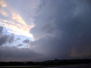
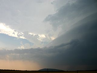
Massive and very intense supercell storm over Washita County, Oklahoma SE of Cordell and near Mountain view. The view is to the north. |
|
View looking NW of the violent supercell storm in Washita County. Note the banding of the updraft with multiple inflow tails! |
|
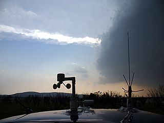
View of some of my roof-mounted equipment (including antennas and anemometer) measuring sustained 40+ MPH inflow southeast of the Washita County supercell. |
|
Large hail falling well ahead of the Washita County supercell. Much giant hail (up to 2.5" in this picture) was thrown far from the storm core (falling from the storm anvil)! |

|
Very large hailstone measuring 2.5" wide and 3.5" long! This was not even in the core of the supercell ... A new Oklahoma state record was set for hail-size (6 INCHES) by this same storm! |
|
Another impressive view, looking west, at the Washita storm. The supercell had a very impressive "barber pole" updraft (with striations) from this vantage point. |
|
Here is a funnel cloud that developed under the Washita, Oklahoma supercell. The storm tried hard to tornado, but despite it's violence, this is all it did "tornado wise". |
|
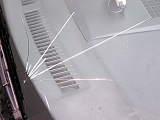
Cracked windshield of my chase vehicle after an encounter with isolated 2.5" hail falling from the anvil of the Washita supercell. |
|
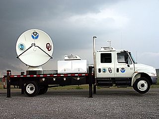
One of many of the University Of Oklahoma's mobile Doppler radar vehicles. Note the struts that raise the vehicle to the radar platform remains level to the earth, regardless of the way the vehicle sits on the ground. |
|
Convective initiation north of Arapaho, Oklahoma. Note the extreme "tilting" of the developing storm towers from the extreme speed and / or directional shear with a change in altitude. |
|
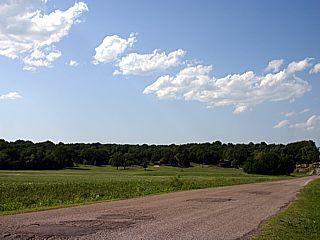
Rain free base and small funnels from a supercell storm near Watonga, OK. |
|
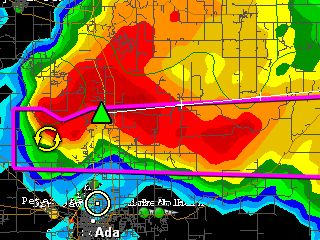
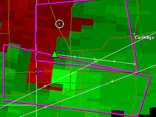
Velocity radar image while I was on a powerful tornadic HP supercell storm on Highway 270 between I-40 and Calumet, OK. Again, notice how close I (white circle) am to the "gate-to-gate" shear ... Check out my "view" at the same time looking south in the next image below! |
|
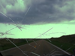
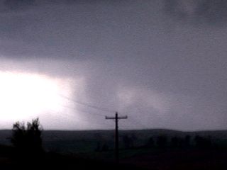
Frightening view looking south on Highway 270 between I-40 and Calumet, OK. This was also about the time the radar image above was captured. It was so dark under this storm (this was only 4 PM), that this image had to be enhanced. A loud roar was audible with this feature as well, and a nearly mile-wide damage path was found after this rain-wrapped wedge tornado passed. This was a confirmed large and violent wedge tornado, partially rain wrapped, and with an EF-5 intensity, the strongest on the tornado scale (winds well over 200 MPH)! |
|
The rain-wrap caused the violent tornado associated with the aforementioned supercell to be very difficult to see. In this highly enhanced image, looking north from near Piedmont, you can barely make out the shape of a tornado near the center of the picture. |
|
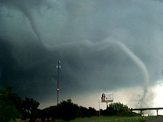
Beautiful rope tornado crossing I-40 under another supercell to the NW of Shawnee, Oklahoma. |
|
Closeup of the Shawnee, OK tornado crossing I-40. This was a small tornado, but the motion of the contact swirl was violent! |
|
Injured truck driver and destroyed semi-trailer after the tornado near Shawnee, OK. This man is lucky to be alive. |
|
Folks giving aid to the truck driver's injuries after the tornado near Shawnee, OK. |
|
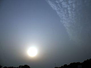
Interesting view looking west behind the storms at the sunset. This is the post dryline air, hazed with dust. |
|
Convective initiation of one of many storm clusters as viewed from I-44. |
|
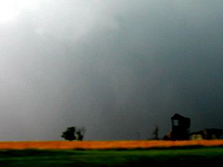
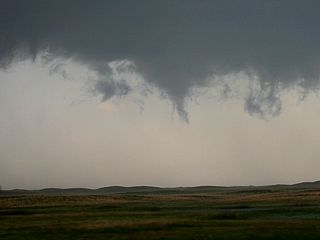
Tornado developing over Fredricktown, MO. The tornado appears as a funnel here, but tree damage later found on the ground confirms a tornado. The view is to the SE. |
|
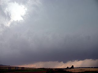
RFD clear slot and rapidly rotating wall cloud associated with a supercell north of Fredricktown, MO. The view is to the north. |
|
Penetrating a severe thunderstorm near Cape Girardeau, MO in near zero visibility and winds gusting over 65 MPH. |
|
Shelf cloud associated with the gust front of a severe storm near I-55. |
|
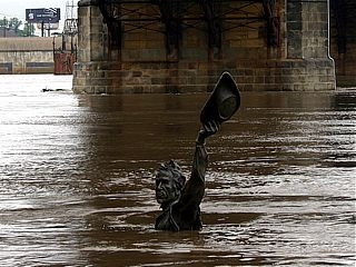
Here is a picture of the Louis and Clark Statue just north of the Gateway Arch Monument. Normally, the statue is two men in a boat, and on dry ground (one of the terraces of the river levee). Only the man standing tall waving his hat is sticking above the swollen river. |
|
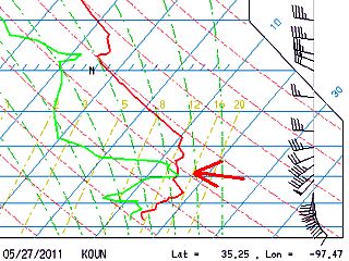
A capping inversion is a warm layer of air aloft that suppresses any convection, despite high instability (CAPE), forcing, and shear. On the Oklahoma University (OUN) sounding, the red arrow points to where this inversion is (in this case, there are multiple tropospheric inversions). The inversions show up as a "nose" on the temperature plot (red line). |
|
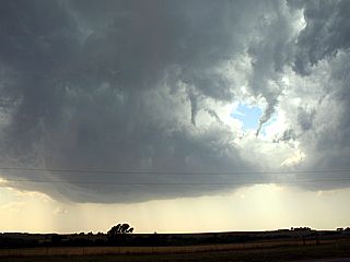
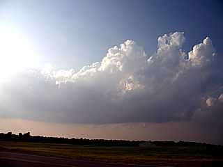
Convection initiating but struggling to go up northwest of Watonga, OK but never reached the LFC (Level of Free Convection). This rather "promising" convection flattened out and evaporated after this picture was taken due to the capping inversion aloft. |
|
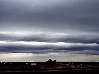
Not much going on here east of Denver, Colorado in cool upslope flow, except for these interesting shelf clouds. Only light convective showers developed. |
|
Thunderstorm anvil and sun obscured by the anvil blowoff while approaching some severe storms near Mitchell County, Kansas from the east. The view is west. |
|
Wide angle shot of a classic to LP supercell northwest of Tipton, Kansas. The view is to the west and northwest. |
|
Despite a high clouds base, an interesting RFD (Rear Flank Downdraft) clear slot develops. |

|
Hail from the LP storm was measured at about 2" in diameter. Note the interesting "rings" in this hailstone, each ring is a trip up and down the thunderstorm updraft (at least 20,000 feet)! |
|
HP supercell storm west of Highway 183 and northwest of Rose, Nebraska. Note the developing wall cloud to the lower-left and inflow "notch". |
|
Developing tornado in HP supercell just before violent squall line evolution near Highway 183 and northwest of Rose, Nebraska. |
|
Cloud-to-ground (CG) lightning strike with HP supercell north of Rose, Nebraska. |
|
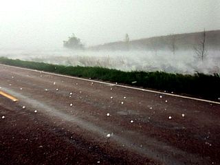
Nearly horizontal hail up to at least baseball sized north of Rose, Nebraska along Highway 183. Note the furious splashing of the water in the roadside ditch! |
|
Time to face the wind and giant hail ... Sacrificing the front windshield to avoid losing any side / rear windows! Damage to the rental was quite costly. |
|
Funnel cloud on HP supercell flanking line just east of Rose, Nebraska and Highway 183 over the Nebraska Sandhills. |
|
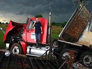
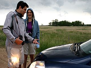
Chasers including Dan Shaw from Australia checking out my new "battle scars" (hail dents) on my chase vehicle. Over $4,600 in damages were done to this vehicle from the hail! |
|
Another HP supercell and greenish-colored hail core to its right looking west of Rose, Nebraska. Note the impressive striations. |
|
Wide angle shot of chasers the "whale's mouth" (underside of shelf cloud) as gust front passes. |
|
Large gustnado and gust front dust plume (haboob) associated with developing derecho as a violent squall line forms. The view is to the SSE. |

|
What ends a great chase trip like a top shelf Margarita? This picture was taken in Kansas City Airport waiting for my flight back to Florida. |
HTML File "mwcl2011.htm" - Developed By Chris Collura
To Return To The HOME Page Of This Site Click The "INDEX.HTM" Link Here!