
| This section is for storm chases done in the central / Midwestern United States during the year of 2009. Since no chase "expedition" (that is where a 2-3 week "block" time was spent chasing at the mercy of whether or not the weather would co-operate) was done this year, all chases in the central USA will be logged in this section. Many chases will be "spot" chases or where only major severe weather "setups" were chased. Here you should find many pictures of lightning, possible tornadoes, along with many severe thunderstorm elements. Keep in mind that this chase log is scientific evidence and portrays my on-going storm chasing research. It has been placed on this page for easy reference and meteorological interests. Please do not plagiarize or copy this document to other sites for distribution. Note - This page may take a while to load on some SLOWER connections! |
STORM CHASING - CENTRAL UNITED STATES - SPECIAL 2009 CHASE LOG
| CHASER NAME | HOME CITY | CALLSIGN | CHASE DATES | OCCUPATION |
| CHRIS COLLURA | MIAMI, FL | KG4PJN | 6-4 TO 6-9 | IT CONSULTANT |
The participants below are not from the "Sky-Chaser" chase team. These people often actively participate in my storm research and documentation efforts and deserve appreciation for their great help and severe weather expertise.
| CHASER NAME | HOME CITY | CALLSIGN | OCCUPATION |
| BRANDON CLARK | HAYS, KS | N/A | OIL WORKER / STUDENT |
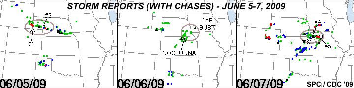
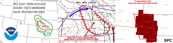
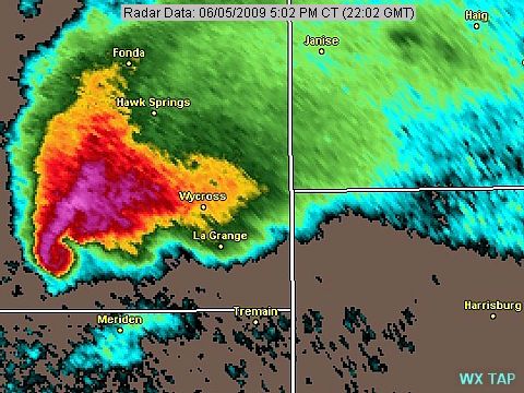
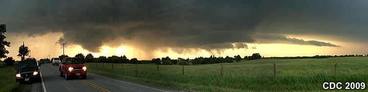
1). June 5, 5:00 PM - Observation of an extremely severe and tornadic thunderstorm over Goshen County, Wyoming and near La Grange. The storm was a violent classic / cyclic supercell that produced a large tornado that was on the ground for nearly 30 Minutes. This supercell storm was observed from a distance ranging from 5 to 25 miles, and the large tornado was visible from as far as Highway 71 south of Harrisburg (Banner County, Nebraska). The tornado did not affect populated areas, and was a large cone tornado with a rope-out stage observed at distance. The core of the storm was not penetrated, and contained winds gusting over 60-MPH, frequent lightning, and hail reported to 4.5 inches (slightly larger than a grapefruit). Conditions producing the storms were surface heating, upslope wind flow, a dryline and boundary (triple point) interactions, low pressure area, and upper trough. Documentation was still digital photos and HD video. A 2009 Chevy HHR was used to chase the storms. A tornado watch was also in effect for the area until 10 PM MDT.
2). June 5, 8:00 PM - Observation and indirect penetration of another extremely severe and possibly tornadic thunderstorm from southeast of Harrisburg in Banner County, Nebraska from near Highway 71 then again to the east in Morill and Cheyenne counties from Bridgeport to southwest of Lisco. This storm was initially a classic supercell storm that produced two large funnels southeast of Harrisburg. The storm also produced hail up to baseball sized at this point. Golfball sized hail was observed at my location. The storm was abandoned as it moved east due to poor roads and picked up again near Dalton along highway 385. At this point, a very large wall cloud was observed with strong rotation and numerous funnels. This could quite possibly have been a broad, weak tornado (EF-0 / EF-1). The storm evolved to HP supercell with a very striking visual appearance / vault southwest of Lisco. Poor roads and isolated hail to baseball-sized warranted another hasty retreat. Heavy rains and 60 MPH winds were also encountered, along with frequent lightning. The worst part of the storm core was not penetrated, and contained 4" (softball sized) hail. Conditions producing the storms were surface heating, upslope wind flow, a dryline and boundary (triple point) interactions, low pressure area, and upper trough. Documentation was still digital photos and HD video. A 2009 Chevy HHR was used to chase the storms. A tornado watch was also in effect for the area until 10 PM MDT.
3). June 7, 5:30 PM - Observation and indirect penetration of an extremely severe, and possibly tornadic thunderstorm along and near the Kansas / Nebraska border / Highway 99 from near Summerfield, Kansas in Marshall County and eastward towards Du Bois, Nebraska near Highways 8 and 50 in Pawnee County. The storm was a classic supercell thunderstorm that was observed from initiation west of Summerfield and followed to its point of weakening to an LP storm (due to its inflow being cut-off from another supercell to the SE). The storm came very close to producing a tornado with excellent rotation and rain wrap during its most intense phase. An unconfirmed report of a tornado was associated with this storm, but only a rapidly rotating wall cloud was observed south of Humboldt. The storm had hail up to softball-sized (4"), but the core was avoided and not penetrated. Winds near 40 MPH (inflow / outflow) were observed along with moderate rain, small hail, and frequent lightning with some close hits. Conditions producing the storms were surface heating, intersecting boundaries (triple point), low pressure area, and upper trough. Documentation was still digital photos and HD video. A 2009 Chevy HHR was used to chase the storms. A tornado watch was also in effect for the area until 11 PM CDT.
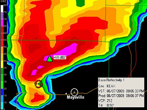
4). June 7, 8:00 PM - Observation and indirect penetration of another extremely severe, and possibly tornadic thunderstorm from near Falls City, Nebraska in Richardson County, across the Missouri River through Oregon, Missouri along Highway 159 / 59, and into Daviess County near Altamonte, MO and Interstate 35. This dangerous classic to HP supercell storm developed southeast of the original supercell storm earlier in Marshall County, KS and had little "competition" from nearby storms (southernmost "Tail-End Charley" cell). The storm core, near Oregon, Missouri, consistently was producing incredible hail approaching, if not exceeding 5" (one chaser report was 5.25")! Hail at least grapefruit sized was observed on the backside of the storm passing through Oregon, with the VORTEX II teams / other chasers creating a massive chaser caravan. The storm produced many rapidly rotating wall clouds / funnels with a powerful (60 MPH+) RFD. Of course, the core was not penetrated, but still winds to 60 MPH, frequent lightning with close hits, torrential rains, and large hail (largest observed falling was quarter sized as the storm weakened later). A large funnel / possible brief tornado was observed with this storm near Maysville in DeKalb County from near Highway 6. Conditions producing the storms were surface heating, intersecting boundaries (triple point), low pressure area, and upper trough. Documentation was still digital photos and HD video. A 2009 Chevy HHR was used to chase the storms. A tornado watch was also in effect for the area until 11 PM CDT.
5). June 7, 10:30 PM - Observation and direct penetration of a very severe, tornadic thunderstorm from near Clinton and DeKalb counties in Missouri, near and west of I-35 and south of Cameron and Osborne. The storm was an HP supercell storm, and hail up to golfball-sized (with isolated pieces to half-dollar) as 1.5" to 2" was encountered with 60-70 MPH winds, torrential rains, and continuous lightning with numerous close hits. A wind shift from strong easterly to strong westerly was encountered when exiting the storm core to the south (mesocyclone). Once clear of precipitation, the storm updraft region was observed from the south at a distance of 5 miles or so, illuminated by the frequent lightning. A large wall cloud, and subsequently, a large silhouette of a tornado became visible for several minutes. Spotter reports confirmed this, putting the tornado in southern DeKalb County over open farmland. The storm weakened and evolved to multicell afterwards. Conditions producing the storms were surface heating, outflow boundary interactions, low pressure area, and upper trough / jet stream aloft. Documentation was still digital photos, audio, and HD video. A 2009 Chevy HHR was used to chase the storms. A tornado watch was also in effect for the area until 11 PM CDT.
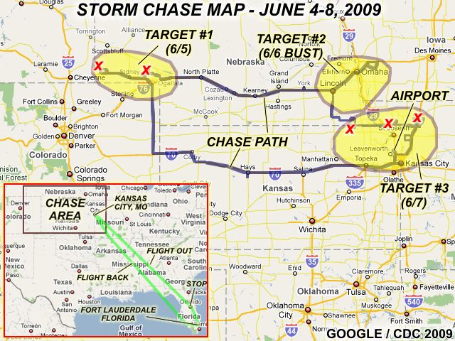
This concludes the Chase Log for the northern US Plains and Midwest tornado chase trip from June 4 through June 8, 2009. The summary includes a total of 5 severe thunderstorms and 4 tornadoes (2 of which were confirmed and one of which was a large tornado that affected extreme eastern Wyoming on the first storm intercepted in this trip). The main chase vehicle conducting all chases was a 2009 Chevy HHR. This information was prepared exclusively for the National Weather service and the team of Skywarn storm spotters.
|
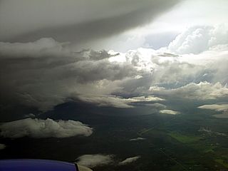
There were several thunderstorms encountered in the air when flying out of Florida en-route to Kansas City. In this picture, a strong thunderstorm can be seen to the left from an altitude of about 20,000 feet. |
|
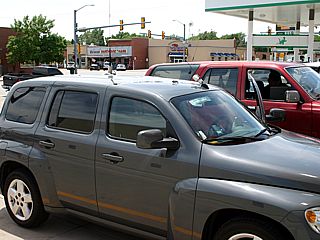
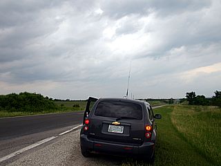
Here is a picture of my Chevy HHR rental and Brandon Clarks 4-Runner while checking data in the small town of Holyoke in the extreme NE corner of Colorado on Highway 385. |
|
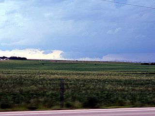
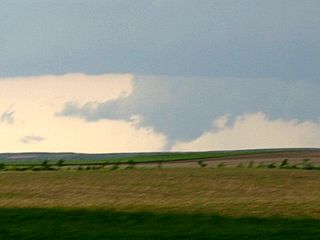
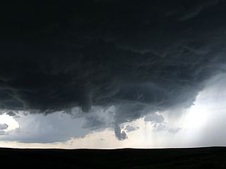
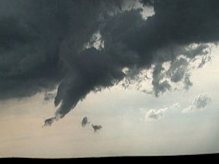
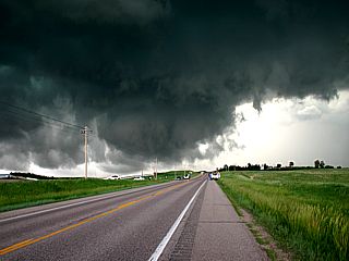
Here is one of the first real views of the wall cloud and distant tornado of the supercell near La Grange, Wyoming from a distance of about 20-30 miles from near Highway 71 south of Harrisburg, Nebraska. The tornado is barely visible in the center of the picture |
|
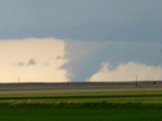
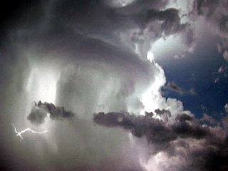
Now this is much more like it ... A large tornado is visible from about 20 miles away from south of Harrisburg, looking west and highly zoomed in towards the wall cloud area of the La Grange supercell. Note the RFD slot in the foreground. Time was roughly 5 PM MDT. |
|
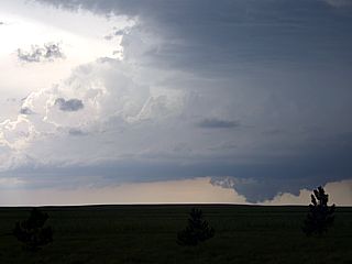
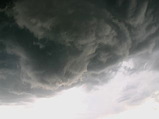
Weakening phase of the La Grange tornado (just before rope out) viewed from the distant vantage point. Visibility in this area (high plains / western US) is extremely good, allowing a fantastic view of a storm that you normally would not see from so far away. |
|
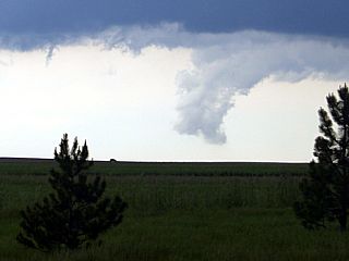
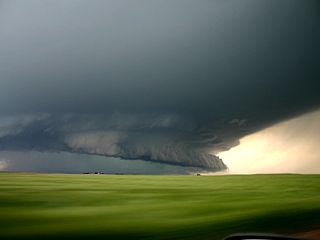
Wall cloud of the La Grange supercell as it crosses the SE Wyoming border into SW Nebraska after tornado dissapation. The RFD slot is still impressive. |
|
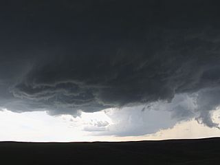
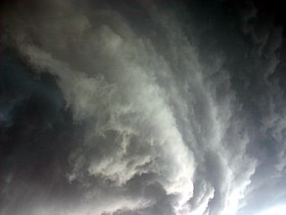
Wall cloud of the La Grange storm weakening into a scud tag like feature by 5:30 PM MDT. Note the little needle / shear funnel on the leading edge of the RFD gust front to the left. |
|
Here is a picture of an intensifying LP / classic supercell to the southeast of Harrisburg, Nebraska. This storm developed southeast of the original (La Grange) storm near highway 71 and was producing baseball sized hail at the time this picture was taken. Note the funnel in the new mesocyclone, and another rotating lowering to the right from the older meso during the storm split. |
|
This is a better view of the splitting supercell storm with two distinct funnels simultaneously. This second storm did not produce a tornado until east of Bridgeport later on, but was a very long track supercell. |
|
Here is another close up of the rotation / funnel associated with the second supercell storm. |
|
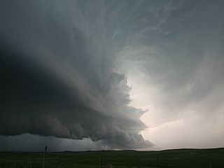
Looking almost straight up at the rotation, incredible striations become apparent with the second supercell southeast of Harrisburg. We are now right under the meso, in the so-called "bear's cage" of the storm. |
|
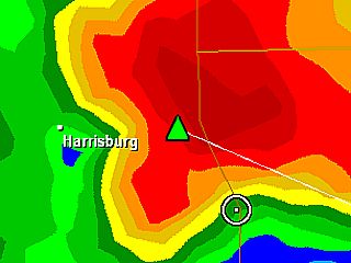
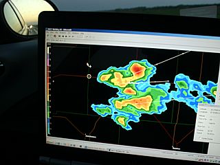
This is from a screen snap-shot of GRLevel3 showing my GPS location as a white circle along Highway 71 at roughly the same time the picture above was taken (6:15 PM MDT or so). I am nearly inside the bounded-weak-echo-region (BWER) of the storm! |
|
The persistant funnel from the older mesocyclone of the splitting second supercell came about half-way to the ground. Not sure if there was any contact swirl or not on the ground underneath it (behind the hill). |
|
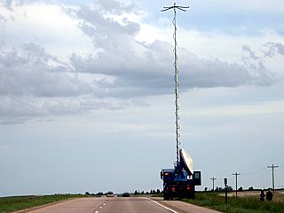
Here is one of the DOW (Doppler On Wheels) trucks scanning the storm and deploying a large antenna for data linkage with the VORTEX II project. |
|
Here is the flanking like (left) and main updraft (right) of the second supercell about an hour later as is was passing to the southeast of Brideport and northwest of Dalton, Nebraska from Highway 385. Note the impressive back-sheared anvil (upper left). |
|
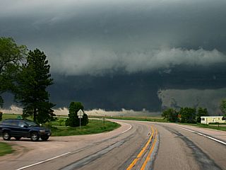
A large, strongly rotating wall cloud drops from the storm base just north of Dalton, Nebraska looking north from town on Highway 385. |
|
Impressive lowering and rapidly rotating wall cloud / possible weak (EF-0 or so) but very large tornado north of Dalton, Nebraska crossing Highway 385. The storm was peaking at maximum intensity at the time, and was passing Dalton to the north. |
|
The Dalton storm continues east, after producing numerous funnels / brief tornado near Dalton and evolves to an HP supercell with this impressive vault (right), wall cloud (center), and intense precipitation core wrapping around to the south side (left). |
|
Here is a view of the vault region to the northeast of the HP supercell southwest of Lisco with full RFD gust front (possibly rain-wrapped tornado at the time) to the lower left. This storm was producing hail up to grapefruit sized (4") prompting a hasty retreat to the south to prevent damage and / or losing windows on my rental vehicle. |
|
Close up view of the impressive vault and cloud-to-cloud (CC) lightning just before getting pounded by baseball-sized hail to the SW of Lisco, Nebraska. |
|
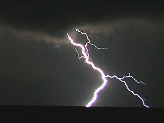
Nice CG (Cloud to Ground) lightning bolt captured on digital still northeast of Chappell, Nebraska after dark as the HP supercell storm evolves to a multicell storm cluster. The updraft base is still visible in the upper part of the picture. |
|
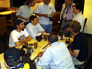
Here is a picture of some great chasers Brandon and I met up with at a steakhouse in Ogalalla, Nebraska. George Kouranis and his Canadian TV crew from "Angry Planet" are mingling with Rocky Roscovich, Bill Hark, and others, showing off the "days tornado catch". |
|
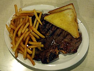
Nothing like a 16 OZ steak after seeing a tornado ... And if you can eat it, they'll bring you another one for free (Ogalalla restaurant off I-80). |
|
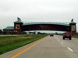
Here is a picture of the Archway Monument that crosses I-80 near Kearney while heading east to our target of SE Nebraska / SW Iowa. |
|
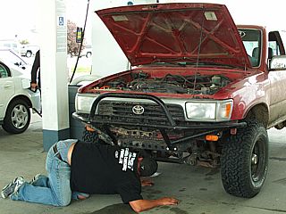
Brandon Clark's 4-Runner was having problems with the starter solenoid. When he stopped in York, Nebraska, it would not start back up. Luckily, his 4-Runner has a manual transmission, so we could push it, and let the clutch out to start the engine in gear, otherwise this would have been the end of his chase-day. |
|
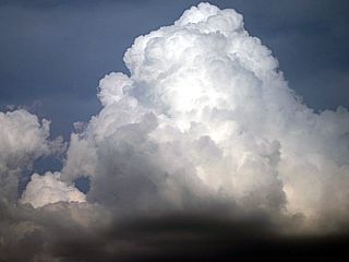
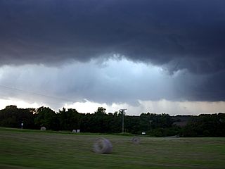
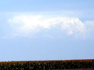
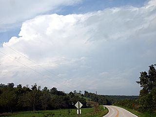
Once in the target area, with a convergance area / boundary east of Omaha, Nebraska and into SW Iowa, a promising build up of cumulus develops near Avoca. There is a very strong cap (temperature inversion aloft) and storms will be supressed by this stable layer aloft. |
|
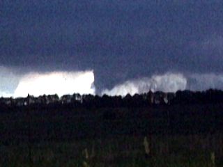
The strong capping inversion quickly snuffs out any vertical growth with the towering cumulus over SW Iowa. The updraft is gone, and a "flattened" cloud top indicates the presence of the strong cap. No storms developed, making this a true "bust" day. |
|
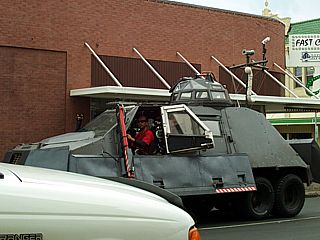
Here is Sean Casey and his new Tornado Intercept Vehicle (TIV II) rolling through Beatrice, Nebraska en-route to the target areas in NE Kansas. |
|
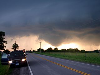
Here is my rental vehicle pulled off to the side of the road as I await thunderstorm development in NE Kansas on Highway 99 in southern Marshall County (NE Kansas). The view is to the NNW at two intersecting boundaries and the first supercell is expected in this area one the cap is eroded by a strong Pacific upper-level disturbance moving in from the west. |
|
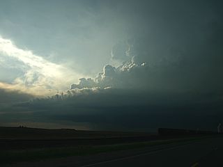
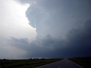
The capping inversion finally breaks, and a supercell updraft goes up in northern Marshall County west of Summerfield, Kansas. Note the stout updraft tower and developing wall cloud to the lower left. |
|
Here is a view of a rapidly rotating portion of the storm, which came very close to producing a tornado south of Pawnee City, Nebraska. |
|
Another supercell develops near the Missouri River east of Falls City, Nebraska and appears with a highly sheared updraft and back-sheared anvil. This supercell eventually cutoff the inflow to the first storm near Pawnee City and became the main "chaser beacon" for many. |
|
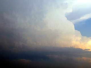
Closer view of the powerful updraft associated with this storm. The second supercell (near Oregon, MO) produced hail measured at 5.25" by one chaser and numerous grapefruit sized (4" or larger)! The speed of this supercell updraft is in excess of 150 MPH. |
|
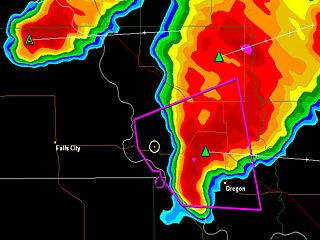
Here is a radar image from GRLevel3 showing my GPS position (the white circle) getting ready to penetrate the rain "hook" to my east. This type of chase is to be done with extreme caution as not only do I have to negociate hail to coconut sized (5" / note the pink cores), but also have to avoid driving into a tornado (if any). |
|
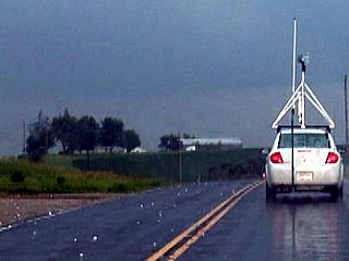
At least baseball-sized hail laying in the road near Oregon, MO. There were much larger pieces but I was too busy driving and did not have time to stop as there was a caravan of chasers / traffic. One of the VORTEX II mobile mesonets is the vehicle in front of me. |
|
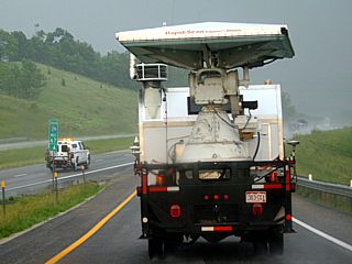
Here is the phased-array rapid-scan DOW (Doppler On Wheels) truck entering I-29 east of Oregon, MO. |
|
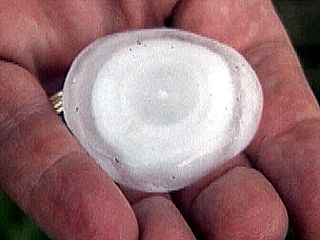
One chaser east of Maysville holds a melted piece of hail collected earlier showing the concentric rings inside the stone. Each ring, like rings in a tree, represents one trip up and down the thunderstorm's 30,000 foot high updraft. |
|
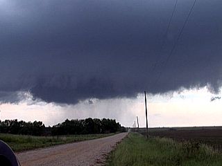
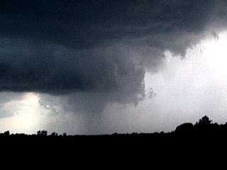
Once east of the storm core, a large RFD (Rear Flank Downdraft) clear-slot can be seen looking north towards the mesocyclone near Rosendale and Highway 71. Note the funnels to the far-left behind the RFD-slot. |
|
A rotating funnel cloud bears down on chasers and the small town of Maysville, Missouri, back-lit by the setting sun. |
|
I took this picture looking west towards the 3end of the Maysville supercell's life-cycle. This feature was rotating, but I am not sure if there is a small rain-wrapped tornado in there. |

|
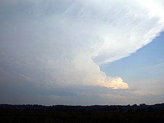
As the second supercell passes I-35 and weakens near Winston, a small LP supercell can be seen to it's west at dusk and in the moisture-starved environment. This small supercell still had a 55 to 60 DBz core on GRLevel3 radar. |
|
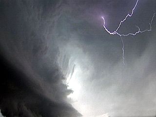
The weakening supercell storm produces an intense display of cloud-to-cloud (CC) lightning and illuminates the upper part of the rotating updraft east of Winston. |
|
This picture is a frame-grab from video of a large tornado (spotter reported and illuminated by frequent lightning) at roughly 10:45 PM CDT looking north at about 5-10 miles south of Cameron, MO and west of I-35. The tornado was over open country and did not strike any populated areas. This is why it is so dangerous to chase supercell thunderstorms after dark. |
|
A cold front / outflow boundary pushes through the northern Kansas City area making for an interesting display with the low clouds. Quite possibly a form of "undulatus asperatus" clouds. |
|
Interesting gravity waves in the low level clouds and mid-level "aspect rolls" / horizontal convective rolls (HCRs) above them (upper-right in picture). The view is from about 25,000 feet in an aircraft (Kansas City to Florida) over Missouri. |
|
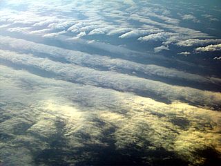
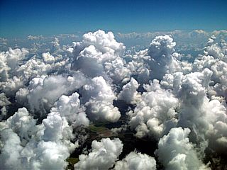
Here is a picture of a dramatic TCU (towering cumulus) field from an aircraft (at about 10,000 feet) returning to Fort Lauderdale during the late morning of June 8 over the Florida Everglades. |
| CHASER NAME | HOME CITY | CALLSIGN | CHASE DATES | OCCUPATION |
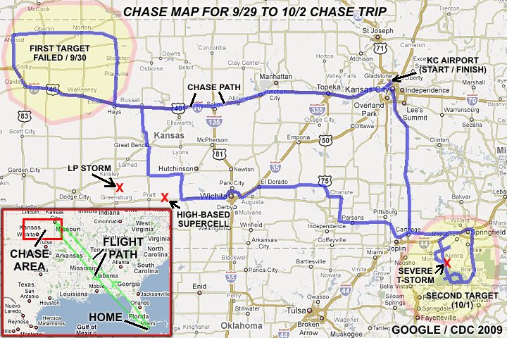
| CHRIS COLLURA | MIAMI, FL | KG4PJN | 9-29 TO 10-2 | IT CONSULTANT |
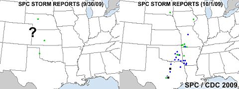
1). Sept 30, 6:30 PM - External observation of a severe thunderstorm near and east of Dodge City, Kansas from Kiowa to Pratt County. The storm was a high-based supercell storm developing ahead of the dryline and on an impinging moisture axis. The storm lasted for about 2 hours, and weakened afterwards. The storm core had hail to at least quarter sized, heavy rains, and frequent lightning. The storm core was not penetrated, but the storm was observed from about 50 miles distance during peak intensity. Conditions causing the storms were a low pressure area, dryline, surface heating, upper trough / jet stream aloft, and convergence area. A 2008 PT Cruiser (Rental) was used to chase the storm. Documentation was still digital photos. A severe thunderstorm watch was in effect for the area until 11 PM CDT.
2). Oct 1, 5:30 PM - Interception and penetration of severe thunderstorms in Barry County, Missouri near and north of Casseville. The storms were part of a line of strong and severe thunderstorms, and contained frequent lightning, heavy rains, ¾” hail, and winds gisting over 60-MPH. Conditions causing the storms were a low pressure area, cold-front, surface heating, and an upper trough / jet stream aloft. A 2008 PT Cruiser (Rental) was used to chase the storm. Documentation was still digital photos and HD video. A severe thunderstorm watch was in effect for the area until 7 PM CDT.
This concludes the Chase Log for the northern US Plains and Midwest storm chase trip from September 30 through October 2, 2009. The summary includes a total of 2 severe thunderstorms. The main chase vehicle conducting all chases was a 2008 Chrysler PT Cruiser. This information was prepared exclusively for the National Weather service and the team of Skywarn storm spotters.
|
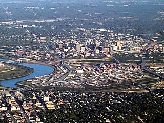
Here is a picture of Kansas City, Missouri, just before landing at Kansas City Airport on September 29. The view is looking east from about 3,000 feet while arriving from Florida. This was my second trip to the Central United States during 2009. |
|
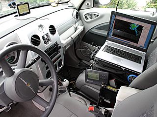
Here is my chase vehicle rental (a 2008 Chrysler PT Cruiser) with all my equipment (laptop, cameras, power hookups, HAM radio, and such) installed and ready to chase for two days. The equipment packs snugly into a small carry on bag in addition to the laptop bag, so setting up for a chase is quick. |
|
Approaching the original target area, in Northwest Kansas, the dryline boundary becomes evident. The convection along the moisture-starved dryline was very high based with temperatures at the surface around 95 degrees F (with dewpoints in the 50's). Looking WSW in this picture, the clouds "stop" above the drier air to the west of the dryline bulge. A dramatic winds shift from SE to SW was also noted across this dryline. Storm development in this area was supressed by a "capping" inversion (warm air layer aloft). |
|
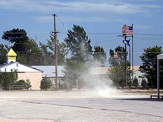
Strong and dry winds from the southwest, gusting over 40 MPH, whip up dust and a small dust-devil as the dryline pushes eastward through Atwood in NW Kansas. |
|
A high-based / elevated supercell thunderstorm looms over the horizon (view is southeast) after abandoning the original NW Kansas target and racing back to the southeast along Interstate 70 while west of Hays. The storm developed in an area well ahead of the dryline and in an atypical location due to the strong "cap" aloft. A speed maximum in the jet stream flow aloft, and "weak" spot in the cap caused this small supercell (east of Dodge City at the time) to develop near the leading edge of a moisture axis (60+ degree F dewpoints) moving in from the south. |

|
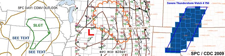
Radar image of the high-based / elevated supercell thunderstorm east of Dodge City, Kansas at the time of peak intensity. The storm was producing hail to golfball sized. Fast motion (40 knots to the NE) made interception of this storm difficult, as it was moving with the stronger winds aloft. |
|
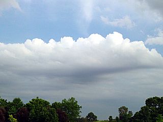
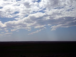
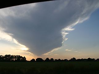
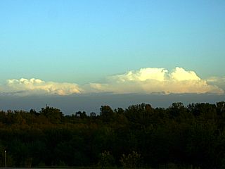
This is a picture of the anvil and storm structure of a weakening high-based LP storm near Jetmore, Kansas on September 30, 2009. The small storm is developing in a very high-shear environment, but moisture is limited ahead of an advacing dryline to the west. The view is to the west. |
|
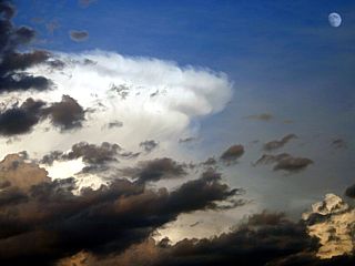
This is a picture of the anvil of a weakening elevated supercell storm, its low-level inflow, and moon near Pratt County, Kansas on September 30, 2009. The storm produced large hail and strong winds, but it's base was too high to produce tornadoes. The view is to the east. |
|
Radar image of the weakening (former supercell) storm as it transitions to multicell mode. |
|
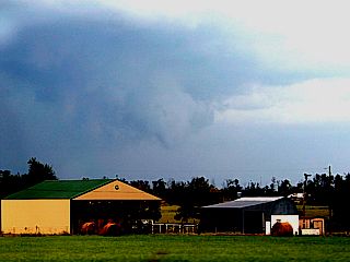
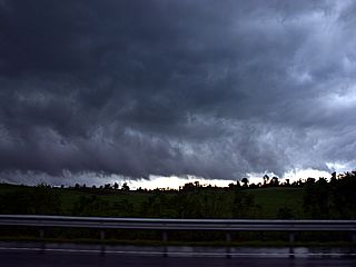
Taken from near Casseville in Barry County, Missouri in the edge of the Ozark Mountains, a developing severe thunderstorm can be seen looking to the northwest towards an advancing cold front / broken line of strong and severe thunderstorms. |
|
I am not sure what this "feature" was in the center of the picture. It could be a shelf cloud (viewed from the side), or a funnel cloud on the leading edge of the severe storm north of Casseville. The view is to the north. |
|
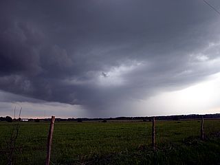
Here is a view of an approaching severe thunderstorm cell associated with the line of storms in southwestern Missouri. The storm here is in Barry County and the precipitation core / hail extends from the center to the right. The view is to the southwest. |
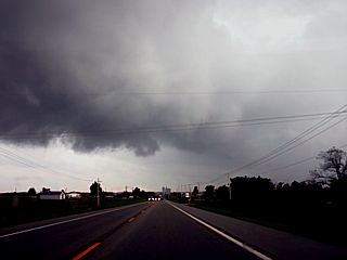
|
Here is a view of one of the more instense severe thunderstorm cells associated with the line of storms in southwestern Missouri. The storm here (in Barry County) has an intense precipitation core with hail (right) and updraft base / shelf cloud (center). The view is to the south. |
|
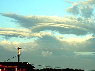
Looking to the west, these strange cloud formations are marked by low level turbulence and outflow just behind the line of severe thunderstorms (and ahead of the cold front) pushing through southwestern Missouri. |
|
Just after the cold front pushed through SW Missouri, and winds shifted from SW to WNW, I noticed these strange cloud formations along the backside of the frontal boundary. This is probably due to turbulence and forcing associated with the cold front and wind shift / shear axis. |
|
Here is a view of the line of strong and severe thunderstorms moving southeast away from southwestern Missouri after passage of the cold front on October 1, 2009. The view is to the southeast. |
|
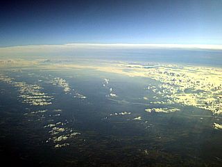
While at altitude (about 38,000 feet) and in flight from Kansas City, MO to Fort Lauderdale, FL, the frontal system is crossed over the upper Dixie states. In this picture, the surface cold front is marked by low clouds and a higher cirrus layer (probably from convective activity / thunderstorms) can be seen ahead of the front. This is the same cold front that originated in Kansas / Colorado on 9/30 and swept through Missouri on 10/1 (a day earlier). |
HTML File "mwcl2009.htm" - Developed By Chris Collura
To Return To The HOME Page Of This Site Click The "INDEX.HTM" Link Here!