
| This section is for storm chases done in the central / Midwestern United States during the year of 2007. Since no chase "expedition" (that is where a 2-3 week "block" time was spent chasing at the mercy of whether or not the weather would co-operate) was done this year, all chases in the central USA will be logged in this section. Many chases will be "spot" chases or where only major severe weather "setups" were chased. Here you should find many pictures of lightning, possible tornadoes, along with many severe thunderstorm elements. Keep in mind that this chase log is scientific evidence and portrays my on-going storm chasing research. It has been placed on this page for easy reference and meteorological interests. Please do not plagiarize or copy this document to other sites for distribution. Note - This page may take a while to load on some SLOWER connections! |
STORM CHASING - CENTRAL UNITED STATES - SPECIAL 2007 CHASE LOG
| CHASER NAME | HOME CITY | CALLSIGN | CHASE DATES | OCCUPATION |
| CHRIS COLLURA | MIRAMAR, FL | KG4PJN | 3-31 | IT CONSULTANT |
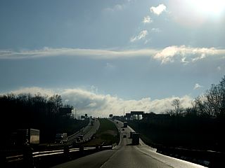
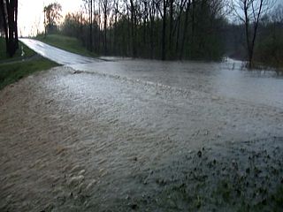
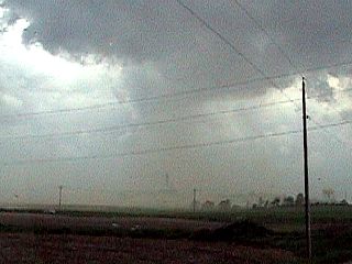
1). March 31, 3:30 PM - Penetration of a severe thunderstorm in Polk County, Iowa just north of Interstate 80 and near Altoona along State Road 945. The storm was part of a multi-cell cluster of severe thunderstorms and contained lightning, torrential rains, winds near or exceeding 60-MPH, and hail up to nickel sized. The storms were caused by a low-pressure trough, surface heating, boundary interactions, and a strong upper-level low-pressure area. A 2007 Ford Focus was used to chase the storms. Documentation was still digital photos and HD video. A tornado watch was also valid for this area until 7 PM EDT.
2). March 31, 6:00 PM - Observation of a small but severe thunderstorm in Dallas County, Iowa just east of Waukee, Iowa along Highway 6. The storm was a small LP type "mini" supercell storm in a highly-sheared environment. The storm produced occasional lightning, and reports of 3/4" hail came with this storm. The hail was not intercepted. The storm produced a lowering and small funnels during its mature stage. The storms were caused by a low-pressure trough, surface heating, boundary interactions, and a strong upper-level low-pressure area. A 2007 Ford Focus was used to chase the storms. Documentation was still digital photos and HD video. A tornado watch was also valid for this area until 7 PM EDT.
This concludes the chase log for the Central Iowa chase trip on March 31, 2007. The summary includes a total of 2 severe thunderstorms. The main chase vehicle conducting all chases was a 2007 Ford Focus. This information was prepared exclusively for the National Weather service and the team of Skywarn storm spotters.
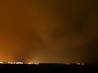
|
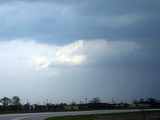
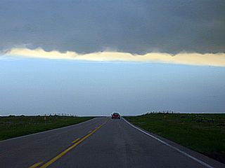
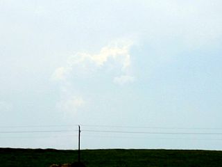
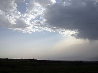
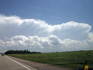
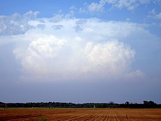
Storms begin to develop as viewed from 40 miles or so east of Des Moines, Iowa. The storms here are developing but forming a line of storms and not supercellular. |
|
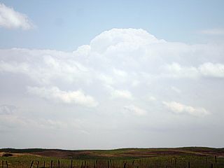
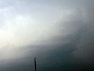
Some of the first thunderstorm cells to go up were low-topped (under 30,000 feet high) in nature. This is due to low surface temperatures (in the 60's F). In this picture, a low topped thunderstorm erupts about 50 miles east of Des Moines, Iowa. |
|
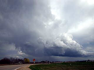
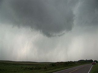
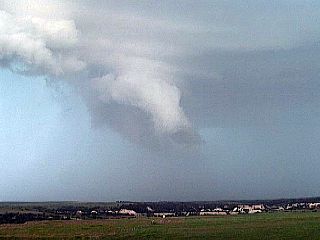
A small but interesting storm cell develops about 45 miles east of Des Moines, Iowa. Note the updrafting scud and small wall cloud associated with this small cell in a highly-sheared environment. |
|
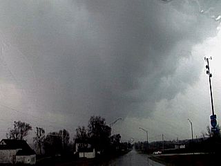
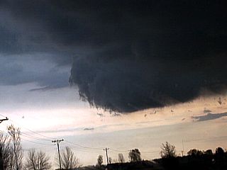
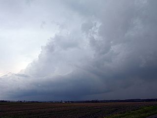
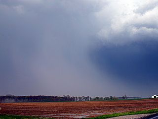
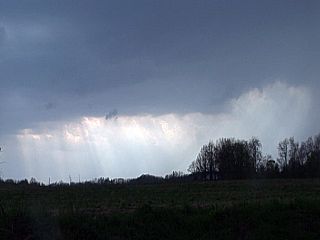
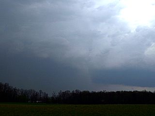
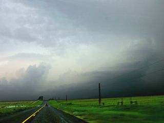
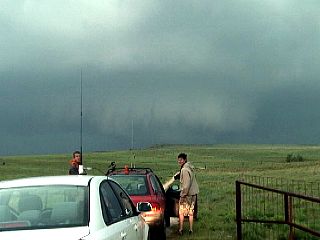
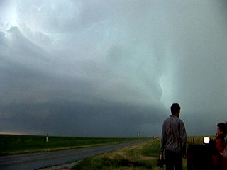
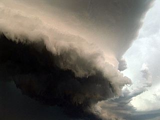
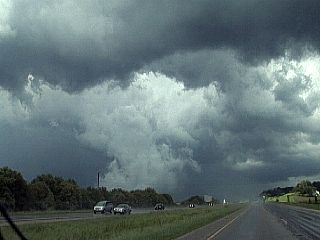
Here is a view of the base and precipitation (rain and hail) of a severe thunderstorm approaching Altoona, Iowa just south of Interstate 80 in Polk County, Iowa. This storm was part of multi-cell line of strong and severe storms pushing through the area. |
|
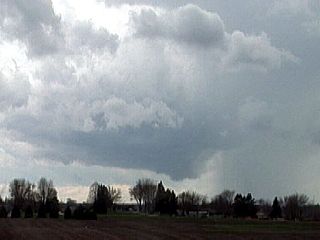
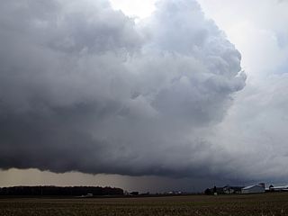
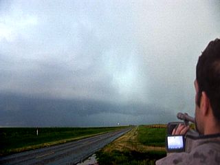
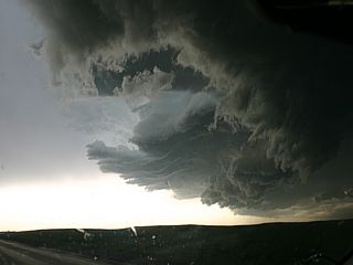
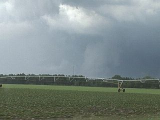
This is a picture of the updraft region of a small "mini" LP supercell storm just west of Des Moines near Waukee, Iowa. An interesting lowering / Wall cloud can be notes with this storm, which also produced nickel-sized hail. The view is to the south and southwest. |
|
Here is a picture of the updraft region of the same "mini" LP supercell storm, developing in a highly-sheared environment, just west of Des Moines, Iowa. The storm is moving rapidly to the north and northeast. Note the small hail core to the lower left (grey streak). The view is to the east. |
|
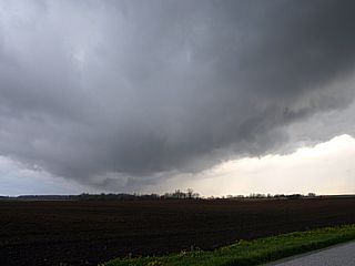
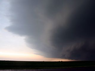
East of the small and weak supercell storm, an RFD-like feature (clear slot) can be seen. The view is to the southwest of Des Moines, Iowa. |
|
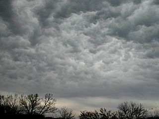
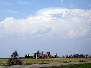
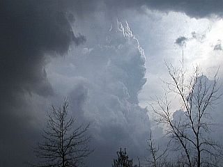
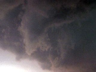
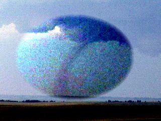
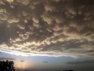
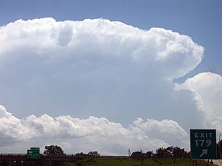
The upper-level low-pressure system not only produces severe thunderstorms, but this incredible display of mammatus-like clouds. The DVA, or differential vorticity advection (upper level low) moving overhead causes this interesting "swirling" mass of clouds high over east-central Iowa. These clouds are an aviation hazard because they present severe turbulence to aircraft. |

|
The chase ends with this spectacular double rainbow as the sun sets. This is approaching the eastern Iowa / western Illinois border on Interstate 80 looking east and northeast. |
| CHASER NAME | HOME CITY | CALLSIGN | CHASE DATES | OCCUPATION |
| CHRIS COLLURA | MIRAMAR, FL | KG4PJN | 4-3 | IT CONSULTANT |
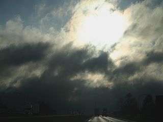
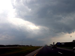
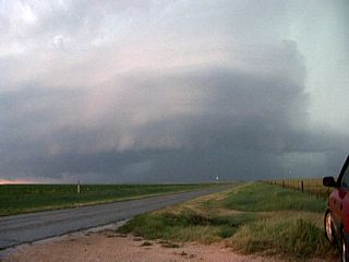
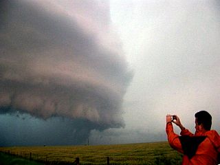
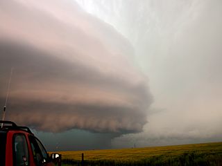
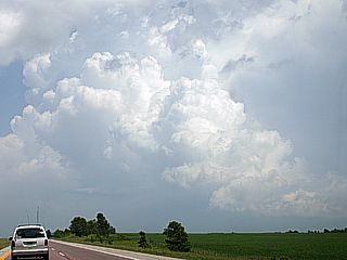
1). April 3, 3:30 PM - Penetration of a severe thunderstorm in Shelby County, Indiana just north of Shelbyville along Highway 9. The storm was at the southern end of a multi-cell cluster / line segment of severe thunderstorms and contained lightning, torrential rains, winds near or exceeding 60-MPH, and small hail. This storm had a spectacular shelf cloud associated with its gust front. Some small funnels were noted on the storms forward flank. Wind damage occured near this storm with power outages, tree damage, and parts of a small out building destroyed. This storm had some HP supercell characteristics but was outflow dominant. The storms were caused by a low-pressure trough, surface heating, approaching strong cold front, and a strong upper-level low-pressure area. A 2007 Ford Focus was used to chase the storms. Documentation was still digital photos and HD video. A severe thunderstorm watch was also valid for this area until 10 PM EDT.
2). April 3, 6:00 PM - Penetration of a very severe thunderstorm in Clark County, Indiana along Interstate 65 and north of Clarksville. The storm was at the southern end of a second multi-cell cluster / line segment of severe thunderstorms farther south than the other segment earlier east of Indianapolis. This storm contained frequent lightning with some close hits, extremely torrential rains, winds gusting over 65-MPH, and nickel-sized (3/4") hail. The main hail core of this storm had hail to 1 3/4" but was not intercepted. This storm had a weak rotating region and prompted a tornado warning for the county to the northeast as well. Power outages and tree damage was also noted with this storm. The storm also caused traffic accidents. This storm had some HP supercell characteristics but quickly became under-cut and outflow dominant. The storms were caused by a low-pressure trough, surface heating, approaching strong cold front, and a strong upper-level low-pressure area. A 2007 Ford Focus was used to chase the storms. Documentation was still digital photos and HD video. A severe thunderstorm watch was also valid for this area until 10 PM EDT.
This concludes the chase log for the Central and Southern Indiana chase trip on April 3, 2007. The summary includes a total of 2 severe thunderstorms. The main chase vehicle conducting all chases was a 2007 Ford Focus. This information was prepared exclusively for the National Weather service and the team of Skywarn storm spotters.
|
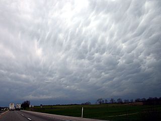
Here is a view of the mammatus associated with the blowoff east of the cluster / line-segment of severe thunderstorms when looking west along Interstate 70 about 50 miles east of Indianapolis, Indiana. The actual storm cells are on the horizon in the lower-left portion of the picture. |
|
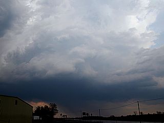
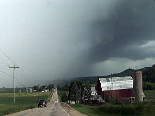
The southern storm of the line of thunderstorms southeast of Indianapolis produces outflow and this large shelf cloud near Shelbyville, Indiana. The view is to the south and southwest. |
|
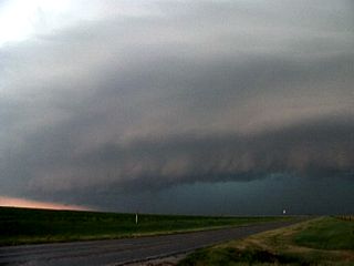
Here is a picture just under the shelf cloud of the severe thunderstorm near Shelbyville, Indiana. The view is to the south. There is also an area of weak rotation (forward flank mesocyclone) forming on the southern end of the shelf cloud in the center of the picture. |
|
This is a closer view of the weak forward-flank low-level mesocyclone on the southeastern side of the severe thunderstorm near Shelbyville, Indiana. The view is to the south and southeast. |
|
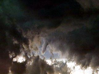
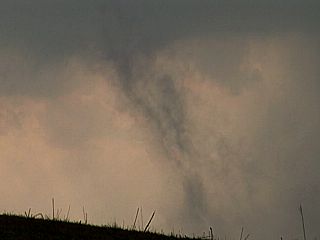
A small funnel cloud develops within the churning mass of clouds associated with the shear-axis of the gust front where southerly winds meet colder stiff northwesterly outflow winds. |
|
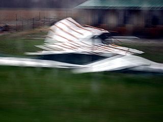
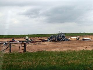
Wind damage observed near Highway 31 and Highway 7 in Bartholomew County, Indiana after the storm line passes. This is a portion of a sheet metal roof blown off a farm stand. This was also across the street from a major car accident at the intersection of Highway 31 and Highway 7. Both were reported to 911 emergency. |
|
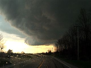
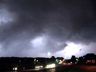
Darkness falls early at 6 PM EDT beneath the base of a severe and tornado-warned storm north of Clarksville, Indiana. This storm contained hail up to half-dollar sized, and was racing eastward at over 50-MPH. |
| CHASER NAME | HOME CITY | CALLSIGN | CHASE DATES | OCCUPATION |
| CHRIS COLLURA | MIRAMAR, FL | KG4PJN | 4-11 | IT CONSULTANT |
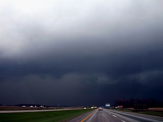
1). April 11, 7:00 PM - Penetration of a severe thunderstorm in Wayne County, Indiana along Interstate 70. The storm was a bow-echo type structure in a multi-cell line of strong and severe thunderstorms. Lightning, torrential rains, winds near or exceeding 60-MPH, and small hail were observed with this storm. This storm also produced an impressive shelf cloud associated with its gust front. The strong outflow winds of the storm also overturned a semi trailer headed westbound on Interstate 70 in Wayne County. The storms were caused by a low-pressure trough, approaching strong cold front and strong surface low, and a strong upper-level low-pressure area (differential PVA and very cold air aloft). A 2007 Ford Focus was used to chase the storms. Documentation was still digital photos and HD video. A severe thunderstorm watch was also valid for this area until 11 PM EDT.
This concludes the short chase log for East-Central Indiana chase trip on April 11, 2007. The summary includes a total of 1 severe thunderstorm. The main chase vehicle conducting all chases was a 2007 Ford Focus. This information was prepared exclusively for the National Weather service and the team of Skywarn storm spotters.
|
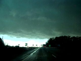
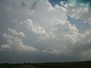
This is the start of this very small local chase. Looking west and heading across the border from Ohio into Indiana along I-70, the distinct cirrus anvil blowoff marks the leading edge of the line of thunderstorms. The sun is heating the ground, through a break in precipitation (called a dry slot) behind a large shield of rain that lasted all day, allowing heating to take place and storms to become strong and severe. The storms are developing along a region of convergence under a region of very cold air aloft. |
|
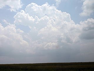
Still headed west, and ahead of the line of thunderstorms, a turbulent layer of cumulus known as "agitated cumulus" develops. This is an indication that the atmosphere is rapidly becoming unstable. |
|
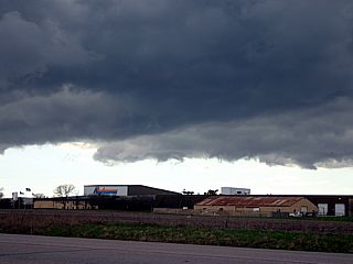
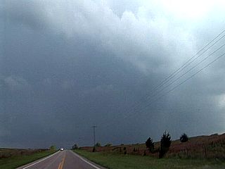
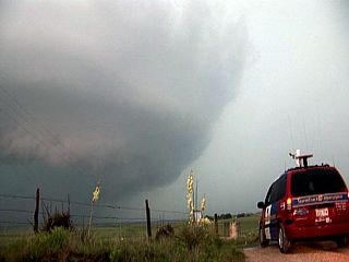
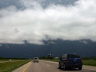
This is a view of the shelf cloud and gust front associated with the intense portion of the bow-segment of the severe thunderstorm line. The view is to the west along Interstate 70 in Wayne County, Indiana. This storm produced hail and winds over 60 MPH, and blew over a tracter trailer in the same county. Note the interesting updraft region to the lower right side of the picture and hail shaft just to its left (center and to the left). |
| CHASER NAME | HOME CITY | CALLSIGN | CHASE DATES | OCCUPATION |
| CHRIS COLLURA | MIRAMAR, FL | KG4PJN | 4-26 | IT CONSULTANT |
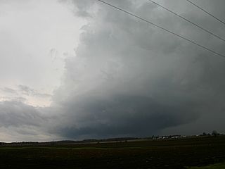
1). April 26, 6:00 PM - Observation of a strong to severe thunderstorm in Union County, Indiana near Highway 27 and Route 44 and west of Liberty Indiana. The storm was a small HP supercell type of storm developing ahead of a squall line of strong and severe thunderstorms. As the line caught up with this short-lived supercell, it evolved into a bow segment and merged with the line of thunderstorms. Frequent lightning with some close hits, torrential rains, winds near 50-MPH, and small hail were observed with this storm. This storm also produced the "stacked-plates" appearance while in supercell mode. A small wall cloud / lowering was also noted at the time of RFD occlusion but did not last long. The storms were caused by a low-pressure trough, approaching surface low, and a strong upper-level low-pressure area (differential PVA / cold air aloft) to the west. A 2007 Ford Focus was used to chase the storms. Documentation was still digital photos and HD video. A tornado watch was also valid for this area until 10 PM EDT.
This concludes the short chase log for Eastern Indiana and Southwestern Ohio chase trip on April 26, 2007. The summary includes a total of 1 severe thunderstorm. The main chase vehicle conducting all chases was a 2007 Ford Focus. This information was prepared exclusively for the National Weather service and the team of Skywarn storm spotters.
|
A small HP supercell storm develops ahead of a line of strong and severe storms in Union County, Indiana near the town of Liberty. The view here is southwest. Note the highly sheared nature of the storm updraft. |
|
Here is another picture of the same small HP supercell storm in Union County, Indiana. In this view here is southwest, you can just make-out the striations on the north and northeast side of the storm updraft. |
|
Here is a view of the line of strong and severe thunderstorms pushing from eastern Indiana into western Ohio. The view is to the north. |

|
The supercell shown earlier became involved with the line of strong and severe storms, although weakening, an interesting "clear-slot" (RFD?) develops in that same area. The view here is to the northeast. |
|
View of the shelf cloud associated with the gust front from the line of strong and severe thunderstorms. The view is to the southwest and the cold outflow is pushing in from right to left. |
| CHASER NAME | HOME CITY | CALLSIGN | CHASE DATES | OCCUPATION |
| CHRIS COLLURA | MIRAMAR, FL | KG4PJN | 5-1 | IT CONSULTANT |
1). May 1, 4:30 PM - Observation of a severe thunderstorm near Wood County, Ohio near Highway 6 30 miles southeast of Toledo and west of Fremont. This storm was a supercell storm, and an RFD (rear-flank downdraft) was noted on the updraft (southwestern side) of the storm. The core of this storm was not penetrated, but contained hail to nickel sized (3/4"). A small wall cloud / lowering was also noted just north of RFD clear-slot but did not last long. The storms were caused by a low-pressure trough, approaching surface low, surface boundary / warm front, surface heating, and an upper trough (NW flow and cold air aloft). A 2007 Ford Focus was used to chase the storms. Documentation was still digital photos and HD video. A severe thunderstorm watch was also valid for this area until 8 PM EDT.
2). May 1, 6:30 PM - Observation and penetration of a very severe thunderstorm near Highway 162 along Old State Road N to the northeast of North Fairfield, Ohio. The storm was a small supercell-like storm on the western end of a cluster of strong and severe storms. When penetrating the storm, large hail (up to 1") was observed covering the ground, along with lightning, heavy rains, and winds over 50-MPH. Some tree damage was noted with this storm. The updraft side of this storm also had some interesting lowerings / funnels, but no tornadoes touched down. The storms were caused by a low-pressure trough, approaching surface low, surface boundary / warm front, surface heating, and an upper trough (NW flow and cold air aloft). A 2007 Ford Focus was used to chase the storms. Documentation was still digital photos and HD video. A severe thunderstorm watch was also valid for this area until 8 PM EDT.
3). May 1, 7:30 PM - Observation of a severe thunderstorm northeast of Ashland, Ohio in Ashland County from north of that area by about 10-15 miles. The storm was a mini supercell for some time before weakening. The core of this storm was not penetrated (but contained hail to 1"). The storm updraft contained weak rotation, giving the updraft a striated appearance (barber-pole). The storms were caused by a low-pressure trough, approaching surface low, surface boundary / warm front, surface heating, and an upper trough (NW flow and cold air aloft). A 2007 Ford Focus was used to chase the storms. Documentation was still digital photos and HD video. A severe thunderstorm watch was also valid for this area until 8 PM EDT.
4). May 1, 8:30 PM - Observation of another severe thunderstorm south of Ashland, Ohio in Ashland County near Interstate 71. The storm was highly outflow-dominant but had some HP supercell characteristics. The core of this storm passed with small hail, frequent lightning, torrential rains, and winds near 60-MPH. The largest impact of this storm that it produced large amounts of rain in a short period of time, and caused flash flooding. The storms were caused by a low-pressure trough, approaching surface low, surface boundary / warm front, surface heating, and an upper trough (NW flow and cold air aloft). A 2007 Ford Focus was used to chase the storms. Documentation was still digital photos and HD video. A severe thunderstorm watch was also valid for this area until 11 PM EDT.
This concludes the short chase log for Eastern Indiana and Southwestern Ohio chase trip on May 1, 2007. The summary includes a total of 4 severe thunderstorms. The main chase vehicle conducting all chases was a 2007 Ford Focus. This information was prepared exclusively for the National Weather service and the team of Skywarn storm spotters.
|
A supercell storm (S of Toledo, OH) looms over the horizon looking northward on I-75 and just north of Lima, OH. The storm here is about 30 miles away, and has an impressive pileus "cap" cloud on its overshooting top. The storm was both severe and tornado warned (radar-indicated) at the time this picture was taken. |
|
A large clear slot is noted on the southern and soutwestern side of the supercell storm, now about 30 miles SE of Toledo in Wood County, OH. This clear area in the center of the picture is caused by sinking air known as a rear-flank downdraft, or RFD. The rotating portion (in the mid levels) of the supercell storm is to the lower right in this picture. |
|
This is a picture of a hail shaft (and hail "foot") from a severe thunderstorm near North Fairfield, OH. If you look closely to the lower left, some "hail fog" can also be seen. |
|
Large hail, anywhere from nickel to quarter sized (3/4" to 1") covers the roadway (Highway 162) to the northeast of North Fairfield, OH. |
|
As hail covers the ground and suddenly melts, an interesting fog forms close to the ground because of the cooling effects of the hail. This is called a HAIL FOG. |
|
This is a picture of the updraft region of the storm east of North Fairfield, OH. |
|
This interesting "feature" caught my eye under the updraft of the storm near North Fairfield, OH. I cannot confirm if this was roating or not, as it can either be a gustnado or scud. Maybe a "sheriffnado"? |
|
Another severe storm goes up in Ashland County near and northeast of Ashland, OH. The stout and rock-hard updraft of this developing small supercell can be seen in this picture through a break in the lower clouds. |
|
Here is a full picture of the lower portion of the small supercell storm that is developing near Ashland, OH. Note the small RFD slot developing near the center of the picture (and slightly right). The view is due south. |
|
This "feature" developed near the weak RFD clear-slot on the small supercell storm near Ashland, OH. I am not sure what this is (near center of picture), but it looks like a narrow hail shaft. |
|
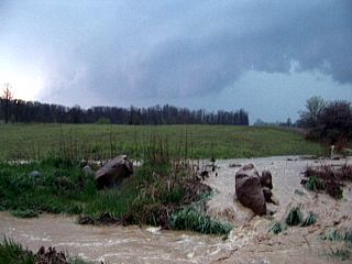
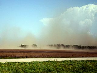
This is a picture, also in Ashland County, of some flash flooding (foreground) that started due to the high rainfall rates of the storms. A severe storm, HP supercell in nature, can be seen in the background with a large shelf cloud ahead of its weak but wet RFD. |
|
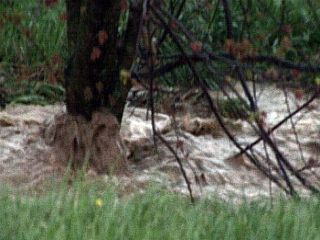
Flash flooding also causes dry creek / stream beds to rise forming small torrents of muddy water. This rushing creek is covering a tree trunk. |
|
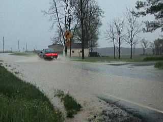
Here is another picture of flash flooding occurring across a roadway in Ashland County. The water here is only several inches deep. |
|
As more storms develop and move over the same area, flash flooding gets worse. This small roadway is nearly impassible due to swift running water across it. |
|
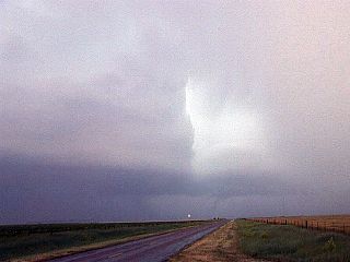
A small shear-funnel type lowering occurs along the shelf cloud of a severe storm moving across Ashland County. |
|
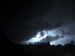
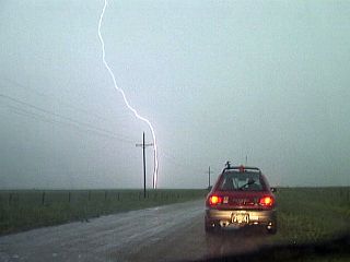
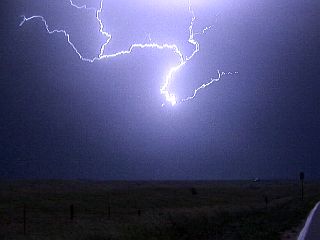
While filming hail and torrential rains and strong winds across Interstate 71 in Ashland County, lightning strikes a tree across the highway about 100 yards away. Unfortunately, the bolt itself is out of frame to the right, but the bright light from it illustrates the intensity of the strike! Note the hail stones in the highway as well. |
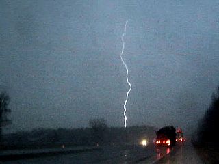
|
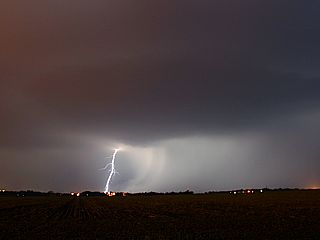
Here is another CG (cloud to ground) lightning bolt over Interstate 71. This one is much father away then the last picture! |
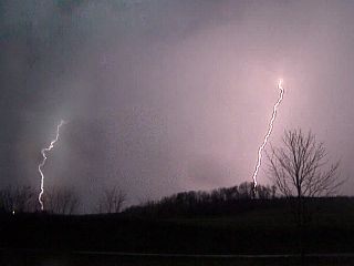
|
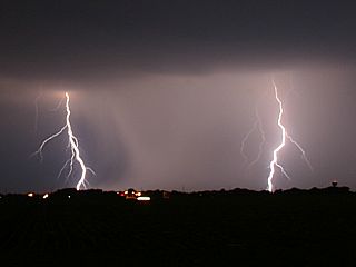
Two more CG lightning bolts poke the ground in southwestern Ashland County north of Interstate 71. |
|
Here is another CG lightning bolt striking the ground north of Interstate 71 in Ashland County, OH. These storms produced a lot of lightning once evolution to multicell (cluster) / linear (squall line) mode occurred near the evening. |
| CHASER NAME | HOME CITY | CALLSIGN | CHASE DATES | OCCUPATION |
| CHRIS COLLURA | MIRAMAR, FL | KG4PJN | 5-15 | IT CONSULTANT |
1). May 15, 6:15 PM - Penetration of a very severe thunderstorm in eastern portions of Whitley County, Indiana on a rural farm road near Dunfee between Highways 30 and 14. This storm was a multicell squall line of severe thunderstorms. This storm had most of its destructive winds well ahead of its precipitation region and was a bow-segment in the line of thunderstorms. At least two major gustnadoes were observed crossing fields in Whitley County. One large gustnado was filled with debris (corn stalks and leaves) and another nearly reached cloud-level. Winds estimated from 70-75 MPH with airborne debris and dust was observed. The storm north of the bow-segment had weak rotation, and a small RFD-like clear slot was noted on its southern side (rotating "head" storm). Only light rain was encountered with this storm, and occasional lightning. The storm also had a history of producing wind damage. Many trees and power lines were observed damaged by the storm. The storm was caused by a prefrontal wave (squall line) ahead of a strong cold front, surface low / trough, surface heating, and an upper-level disturbance. A 2007 Ford Focus was used to chase the storms. Documentation was still digital photos and a camcorder. A severe thunderstorm watch was also valid for this area until 10 PM EDT.
2). May 15, 11:00 PM - Penetration of another severe thunderstorm on the western side of Springfield, Ohio north of Interstate 78 and along Highway 68 in Clark County, Ohio. This storm was an HP supercell storm embedded in a cluster of strong and severe thunderstorms. A tornado warning (radar-indicated) was issued for this storm. A large wall cloud was observed, illuminated by nearly continuous lightning, north of Interstate 70 and near Medway. Funnels or tornadoes, if any, were not observed. The core of the storm passed and produced torrential rains, 60-MPH winds, frequent lightning, and hail up to dime-sized (1/2"). Some tree damage and power outages were also noted in the path of this storm, which also had a wind-damage history. The storms were developing ahead of a strong cold front, and were supported by a surface trough / low and an upper level disturbance. A 2007 Ford Focus was used to chase the storms. Documentation was HD video. A severe thunderstorm watch was also valid for this area until 3 AM EDT.
This concludes the chase log for Northern Indiana and Ohio chases on May 15, 2007. The summary includes a total of 2 severe thunderstorms and at least two large gustnadoes. The main chase vehicle conducting all chases was a 2007 Ford Focus. This information was prepared exclusively for the National Weather service and the team of Skywarn storm spotters.
|
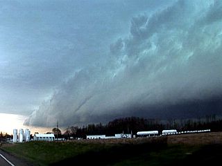
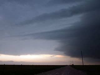
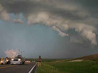
Here is a picture of the shelf cloud associated with the gust front of a very intense squall line moving through eastern rural sections of Whitley County, Indiana near Arcola south of Highway 30. This is a portion of the squall line called a "bow echo" because it appears as a "bow" on radar. Very strong winds are associated with this type of thunderstorm line. The view is to the west. |
|
A strong gustnado crosses a rural farm road in Whitley County, Indiana and is filled with rapidly rotating debris (dust, leaves, and corn-stalks)! |
|
Here is another larger gustnado about 500 yards away to my north with dust nearly reaching cloud level. I am also getting battered by 70 to 75-MPH winds from the west, along with flying corn-stalks, dust, dirt, rocks, etc. |
|
This is a view of the thunderstorm cell north of the "bow-segment" of the squall line moving through Indiana north of Fort Wayne. This cell has rotation, maked by an RFD-like clear slot in the cloud base (brighter region cutting in from left to right). The view is to the north. |
|
Here is a view, looking northeast in Montgomery County, OH (north of Dayton) at the rear-flank of a tornado-warned (radar indicated) severe storm. Interesting lowerings / wall cloud features are illuminated by lightning. This storm was at about 11:00 PM at night and was a rotating storm embedded in a cluster of strong and severe thunderstorms. |
|
Here is another view of the tornado-warned storm moving from northern Montgomery County into Clark County, Ohio. Wall cloud is unmistakable to the left as lightning illuminates the (vault?) and / or precipitation core. The view is to the NNE. |
|
This is another picture of the severe thunderstorm and (radar indicated) tornado-warned storm. The wall cloud (view is to the NE) is entirely illuminated by frequent lightning (it's 11:30 PM EDT). Note the possible RFD clear slot to the left, and a very interesting lowering to the lower-left. The storm here is in Clark County, Ohio and is west of Springfield and north of Interstate 70. |
|
The storm core passes through the western portions of Springfield, OH and produces 60-MPH winds and hail from pea to dime sized. |
| CHASER NAME | HOME CITY | CALLSIGN | CHASE DATES | OCCUPATION |
| CHRIS COLLURA | MIRAMAR, FL | KG4PJN | 5-22 TO 5-24 | IT CONSULTANT |
The participants below are not from the "Sky-Chaser" chase team. These people often actively participate in my storm research and documentation efforts and deserve appreciation for their great help and severe weather expertise.
| CHASER NAME | HOME CITY | CALLSIGN | OCCUPATION |
| MICHAEL CARLSON | DENVER, CO | N/A | STUDENT |
| VERNE CARLSON | DENVER, CO | KB0ZCQ | IT |
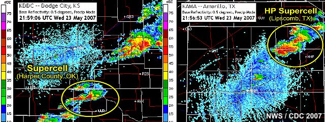
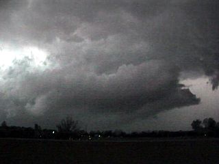
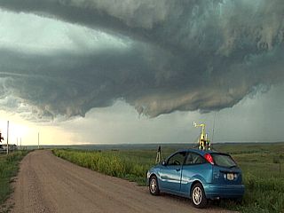
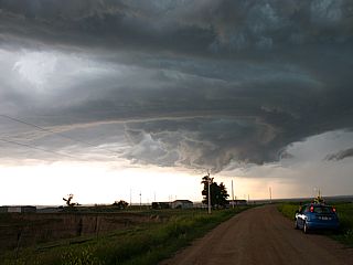
1). May 23, 5:00 PM - Observation and interception of an extremely severe (and tornadic) thunderstorm in Harper County, Oklahoma near Laverne and west of Buffalo along Highway 270 and Highway 46. This storm was a classic supercell thunderstorm developing just south of a quasi-stationary / warm front boundary and well-ahead of a dryline in very unstable air. The storm explosively developed during convective initiation (capping inversion breeched or overcome), quickly became severe, and developed a mesocyclone in a short period of time. The storm had a large, and rapidly rotating wall cloud / funnels, then (just before RFD occlusion) finally produced a brief tornado lofting tree debris over Highway 46. Partially melted hail was noted on the ground south of this storm, and was measured at golf ball (1.75") to hen's egg (half dollar, or slightly more than 2") sized. Deeper into the storm core, 6 miles west of Buffalo, softball sized hail to 4.25" was confirmed (this size was not intercepted by myself and my group). Winds near 50 MPH were also noted with the storm RFD (Rear-Flank Downdraft). The storm lasted about an hour and a half before moving north of the stationary front and weakening. Conditions producing this supercell storm were directional wind shear (surface low / upper trough), dryline and frontal boundary (ahead of triple-point), and surface heating. Documentation was still photos and HD video. A 2006 Suzuki Aerio sedan was used to chase the storm. A PDS (Particularly Dangerous Situation) tornado watch was also valid for this area until 11 PM CDT.
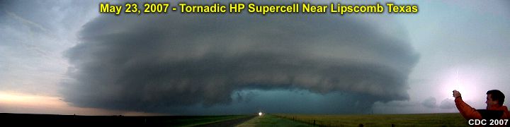
2). May 23, 7:00 PM - Observation and interception of another extremely severe (and possibly tornadic) thunderstorm in Lipscomb County, Texas from near Lipscomb along Highway 305 and points north / northeast. This storm was an HP supercell thunderstorm developing on the southern end of a line of thunderstorms (tail-end Charley). This storm had a large, and slowly rotating wall cloud and several funnels were observed. Some of these wall clouds were observed very close to the ground. This HP (High Precipitation) supercell lasted for roughly 3-4 hours. It had a very impressive visual appearance, with the "stacked-plates" (barber-pole) effect, and visual BWER (Bounded Weak Echo Region, or "vault"). This storm also produced exceptionally large hail, with the largest sizes encountered as big as golf balls during fringe encounters with the core of this storm. This storm also produced very powerful and frequent lightning with many close hits. When in its weakening stages / evolution to multicell cluster (MCS), winds gusting over 75-MPH were encountered on the north side of the storm (mesocyclone) with a wind shift from strong west to easterly and large hail when heading northward. This storm also produced flooding and extremely heavy rains. Conditions producing this storm were directional wind shear (surface low / upper trough), advancing dryline, and surface heating. Documentation was still photos and HD video. A 2006 Suzuki Aerio sedan was used to chase the storm. A PDS (Particularly Dangerous Situation) tornado watch was also valid for this area until 11 PM CDT.
3). May 23, 9:30 PM - Penetration of a severe thunderstorm while heading east on Highway 64 and just west of Buffalo, Oklahoma in Harper County. This storm was a multicell cluster of severe thunderstorms. Torrential rains, 60-MPH winds, frequent lightning, and hail up to nickel-sized (3/4") was encountered during the passage through this storm. This storm was part of a large MCS of thunderstorms, and was caused by outflow boundaries, frontal convergence (warm front), an upper trough, and surface heating. A 2006 Suzuki Aerio sedan was used to chase the storm. Documentation was HD video. A PDS (Particularly Dangerous Situation) tornado watch was also valid for this area until 11 PM CDT.
This concludes the chase log for Kansas, Oklahoma, and Texas (panhandles) on May 23, 2007. The summary includes a total of 3 severe thunderstorms and at least one tornado. The main chase vehicle conducting all chases was a 2006 Suzuki Aerio sedan. This information was prepared exclusively for the National Weather service and the team of Skywarn storm spotters.
|
Preparing the chase vehicle (A 2006 Suzuki) after flying into Kansas City on May 22 and arriving in Abilene, Kansas for the previous night. |
|
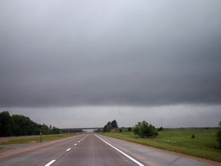
Looking west while driving along Interstate 70 east of Salina, Kansas, the cold front stretches across the sky through the grey "grunge". Temperatures here are cool and there is much cloud cover from previous storms the night before. Ofcourse, the target area is still hundreds of miles away, where this front becomes more "positively" tilted (oriented nearly east to west rather than north to south as in this picture). |
|
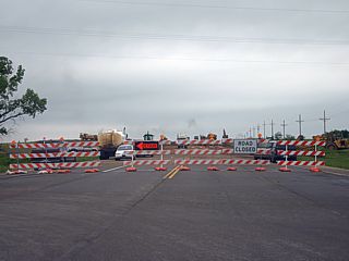
This is not something a storm chaser likes to see. Luckily this was encountered heading south on Highway 56 in central Kansas with plenty of time to divert (detour) around and still make the target area later on. Another area of construction was also southbound on Highway 283 south of Sitka. In this case, a woman simply told everyone to "pull over to the LEFT" side of the road and wait" as there was "equipment on the bridge". About 45 minutes later, with dozens of trucks and people still waiting, the same woman simply said "I don't know" when I asked her how long the delay would be. An alternate route around that area took no more than 15 minutes. Such road construction can effectively hose-up a good chase if a chase team was rushing to meet a supercell. |
|
Severe thunderstorms begin developing just north of the Kansas / Oklahoma border. The cell here has an overshooting top, and is roughly 30 miles away. These storms are NOT in the target area, as they are developing along a portion of the cold front. |
|
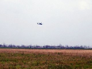
Here is a view of the devastated city of Greensburg, Kansas while traveling southward along Highway 183 just north of Highway 64. An EF-5 tornado, nearly TWO MILES wide, struck this town about 3 weeks before this picture was taken (during the late-evening May 4, 2007). Disaster relief is still underway as a helicopter circles overhead. |
|
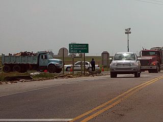
Here is the intersection of Highways 183 and 64. Highway 64 eastbound is closed at this point via a police checkpoint. Only disaster relief personnel, law enforcement, and residents with escorts were allowed to pass. Note the debris still strewn along the side of the road. Trucks are carrying away trees and debris to a dump and burning pit to the north of the area. |
|
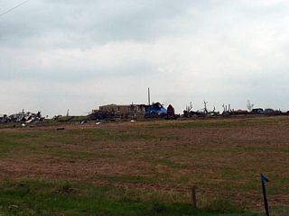
Here is a severely damaged farmstead just west of Highway 183 and to the SSW of Greensburg, Kansas. If you look closely at the center of the picture, a large blue colored farm vehicle is flipped and most of the roof of the building is missing. |
|
Here is another building that was taken out by the Greensburg, Kansas tornado. To the left of the picture is a concrete slab where the building once stood. The pile of mangled material is what's left of the house / building, and lies in a heap to the right. Keep in mind, this is 3-weeks AFTER the tornado hit this area. |
|
In the target area of Harper County, Oklahoma, a stout buildup of cumulus makes its appearance marking convective initiation. It is now time to change from "waiting" to "chasing" and make my way towards this developing (soon-to-be) storm. |
|
After passing through Laverne in Harper County, Oklahoma, the relatively small cumulus towers you saw in the last picture "explode" into a full-fledged thunderstorm with an anvil. This storm developed in only 15 minutes, and is well on its way to become a supercell. |
|
Looking south (highway 283) at the developing storm in Harper County, Oklahoma, a developing "beaver's tail" inflow feature can be seen to the lower left as well as some "banding" to the upper right. The core of the storm is just right of the center of this picture. |
|
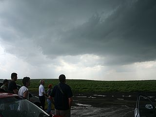
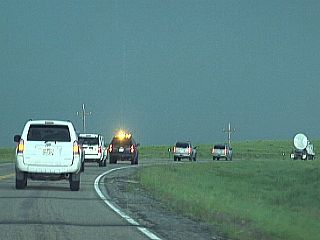
And guess who I run into when I reach the inflow side of the storm? Storm chasers! Here, father-and-son chase team Verne and Michael Carlson watch the storm with several others in Harper County, Oklahoma just south of the intersection of Highways 283 and 270. A developing supercell, especially in a small target area, acts like a "beacon" - Where storm chasers within range converge on it from all around. Normally desolate country roads actually become jammed with "chaser traffic" and caravans with many standing along the side of the road watching as if a once-a-year sporting event was taking place! |
|
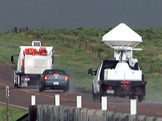
Scientific groups are also sharing the now busy roads in a "supercell environment". In this picture, the DOW (Doppler On Wheels) vehicles race north to catch the Harper County supercell along Highway 283. |
|
The Harper County storm becomes more organized and begins rotating hard. This picture was taken looking northward along Highway 270 between Highways 283 and 46 near Laverne, Oklahoma. Verne Carlson is standing to the right as the storm develops a rotating wall cloud with funnels. |
|
One larger funnel develops on the wall cloud of the Harper County storm. I cannot tell if anything is on the ground under this feature, but it looks close! |
|
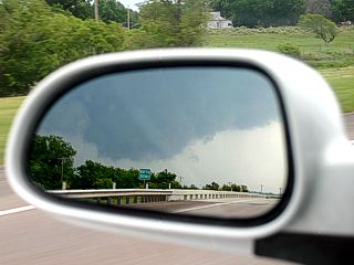
While driving east on Highway 270 to meet a north option on Highway 46, I see the view of the developing wall cloud / tornado in my rear-view mirror. |
|
The wall cloud of the Harper County storm is still rotating but I have not seen anything (such as a tornado on the ground) develop out of it yet. Continuing north on Highway 46 while the wall cloud develops a beautiful inflow tail. |
|
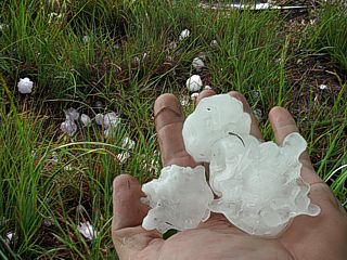
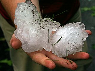
Partially melted giant hail was found on the ground behind the Harper Oklahoma supercell storm near Highway 46. Some pieces were measured at over 2" (most being the size of golf balls). This was NOT the largest hail this storm produced. Confirmed reports of softball sized hail occurred with this storm (4.25") - Ouch! |

|
This partially melted golf ball sized hailstone has some interesting radial "ice-cicles" on its edge. |
|
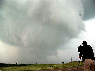
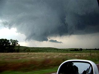
This is a picture of the funnel DIRECTLY under the wall cloud of the Harper County supercell near Highway 46. This picture does not do any justice on how fast the rotation was overhead. Shortly after, the storm finally tornadoed with a touch-down about 200 yards up the road (Highway 46) with a brief debris cloud and some tree debris airborne. |
|
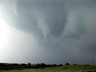
This is a view of the tornado just after touching down briefly along Highway 46. The tornado (and it's parent supercell) weakened as the RFD (Rear-Flank Downdraft) occluded and the storm moved northeast into cooler air across the stalled cold / warm front boundary. |
|
Don't get "blown-off"! We are now headed south along Highway 283 towards Highway 60 due to a new batch of supercells near Lipscomb County, Texas. The Harper supercell has weakened and our new supercell storm is at the southern end of a line / cluster of supercells. The southern cell, called "Tail-End Charley" is often the more intense right-split. Anvil blowoff and mammatus overhead is impressive looking southward. The supercell(s) to intercept are about 30-40 miles to our WSW. |
|
Heading west on Highway 60, the supercell storms (in Lipscomb County, Texas) become apparent and are clearly HP (High Precipitation) supercells. Note the rotation of the "Tail-End Charley" supercell to the center and right of this picture. The striations are apparent as well as the slanting of the storm updraft due to the directional shear. |
|
Looking closer at the HP storm in Lipscomb County, Texas, the striated (and tilted) updraft resembles stripes on a barber pole. Chasers call this a "Barber Pole" updraft. |
|
Interesting mid-level shear funnel appears on one of the highly-sheared cumulus towers ahead of the supercell storms in Lipscomb County, Texas. |
|
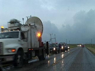
The DOW (Doppler On Wheels) vehicles are parked along the side of Highway 60 just outside of Lipscomb, Texas. The other vehicles with instrumentation are from the ROTATE (Radar Observations of Tornadoes And Thunderstorms Experiment) team working with the DOW crew. |
|
Here is the TIV (Tornado Intercept Vehicle) also observing the storm to their northwest in Lipscomb County, Texas. This group gets close to a tornado, really close! They work with the ROTATE / DOW groups as well as getting in-situ video and / or near inflow field measurements of tornadoes if possible. |
|
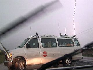
Here is a picture (video frame-grab) of one of many tour group vans observing the Lipscomb supercell parked along highway 305. Lightning strikes behind as tourists take pictures of either me or the monster HP supercell that is behind me! |
|
I am not sure what I am looking at since I cannot confirm if this "feature" is on the ground or not. Nevertheless, it was rotating and could quite possible be a large tornado about 5 miles or so west of Highway 305 in Lipscomb County, Texas. Verne and Michael Carlson are in the foreground. |
|
Here is a view (channel 10 news is in the foreground chase vehicle to the right) of the HP supercell near Lipscomb County, Texas. I have even seen a helicopter "chasing" this storm as well as the other supercell in Harper County, OK earlier! |
|
Another large CG (Cloud to Ground) lightning strike while heading east on a farm road from Highway 305 to get a better look at the Lipscomb HP storm to our west - and also to stay out of the large hail. |
|
This is a small funnel that formed on the gust front of the wet RFD of the Lipscomb HP storm. The view is due south. |
|
Here is a view of the HP Supercell storm near Lipscomb, Texas. Beautiful storm structure with frequent CG lightning and "stacked plates" mesocyclone. |
|
This is the spectacular shelf cloud associated with the gust front of the wet RFD that was associated with the HP storm near Lipscomb, Texas. |
|
Amazing inflow bands just east of the HP supercell in Lipscomb County, Texas. |
|
At one point the Lipscomb HP storm had a spectacular vault region (clear area between precipitation to the right and updraft to the left). On radar, this creates a region of lower reflectivity and is called a BWER (Bounded Weak Echo Region). This area is also where the pargest hail is falling. The nearly vertical updraft (core) is just left of the vault, and is right over the circulation "center" of the mesocyclone. Tornadoes, if any, are hidden from view behind the wet RFD precipitation. |
|
Here is another picture of the vault region and HP supercell in Lipscomb County, Texas as other chasers Verne and Michael Carlson awe at the view. |
|
The HP supercell in Lipscomb County, Texas develops an interesting "beaver's tail" inflow feature on its northeastern side as chasers capture the show with their camera gear. |
|
Here is another, and closer view of the approaching gust front (and shelf cloud) of the Lipscomb, Texas HP supercell. This is associated with the gust front of the wet RFD (precipitation filled) part of the storm. |
|
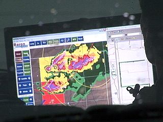
This is a view of the laptop screen in chasers Verne and Michael Carlson's vehicle showing the Baron WX Worx radar screen with HP supercells. This is a subscription-based package, allowing real-time radar information via XM satellite, and is a bit pricey. |
|
This is the northeastern side of the monster HP supercell in Lipscomb County. The rotating portion of the storm, and "notch" is from the center of the picture to the left. If the storm was producing a tornado, it would be to the lower left, but is inviaible as the precipitation of the wet RFD would be obscuring it. Motion wise, feature to the left of this picture are moving left to right, but those on the right are moving right to left - Into the storm. Verne Carlson is to the right taking pictures. |
|
Here is another picture of the notch and incredible banding / striations of the HP supercell near Lipscomb. The notch of the storm is just below the center of this picture and "hidden" tornadoes possibly left of that area. It is very difficult (and dangerous) to try to enter this tight area of an HP supercell to see any tornadoes (called the "bear's cage"). The "stacked plates" effect gives the storm updraft a striated "space ship / flying suacer" appearance. Note the "beaver's tail" inflow feature to the lower right. |
|
While wrapping up the chase of May 23, the Lipscomb storm seemed to weaken somewhat, so Verne's group and myself decide to drive northwards along Highway 305. The "notch" area is just above us and a 70-80 MPH RFD wind just grazed me after I took this picture. The strong winds were from the west, then shifted to easterly just north of this area. Apparently, this is the "bear's cage" of the storm. Hail encountered was also golf ball sized with zero visibility sideways rains. The RFD in this picture also can be seen to the upper-left. INTENTIONALLY core-punching a supercell is extremely dangerous and I do not recommend it! |
|
The chase day ends with an incredible lightning show just before making my long drive back to Kansas City, Missouri for my flight home early the next morning. |
| CHASER NAME | HOME CITY | CALLSIGN | CHASE DATES | OCCUPATION |
| CHRIS COLLURA | MIRAMAR, FL | KG4PJN | 5-25 To 5-27 | IT CONSULTANT |
|
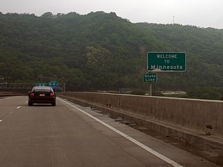
The target area was in the area near Lacrosse, Wisconsin, which is just across the upper Mississippi River from Minnesota (near Winona). |
|
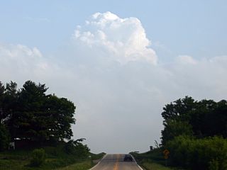
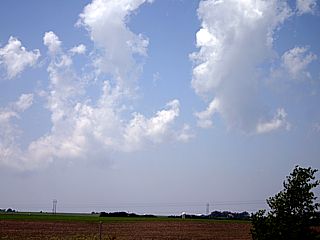
Cumulus tries hard to develop despite the limited instability once the cloud-cover and cool temperatures give way to the sunshine (and heating) within a mid-level dry-slot between the cold and warm fronts. This is near Lacrosse, Wisconsin. |
|
This is the "storms" at their high-point. Highly-sheared and low topped cold-core type stuff. The limited instability prevented anything to really get going. The convective "cell" in this picture almost looks "LP" in nature, but it did not stay this way very long. The view is to the west from south of Interstate 90 east of Lacross, Wisconsin. |
|
As the sun sets and daytime heating goes away, the towering cumulus also "peters out". The cumulus tower here shows its "slanted" appearance as it is toppled over by the directional shear just before disipating. |
| CHASER NAME | HOME CITY | CALLSIGN | CHASE DATES | OCCUPATION |
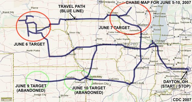
| CHRIS COLLURA | MIRAMAR, FL | KG4PJN | 6-5 TO 6-10 | IT CONSULTANT |
The participants below are not from the "Sky-Chaser" chase team. These people often actively participate in my storm research and documentation efforts and deserve appreciation for their great help and severe weather expertise.
| CHASER NAME | HOME CITY | CALLSIGN | OCCUPATION |
| AMOS MAGLIOCCO | BLOOMINGTON, IN | KC5VPD | WRITER |
| ERIC NGUYEN | NORMAN, OK | KD5HPZ | METEOROLOGIST |
| TONY LAUBACH | LITTLETON, CO | KC0ONL | STUDENT |
| VERNE CARLSON | DENVER, CO | KB0ZCQ | IT |
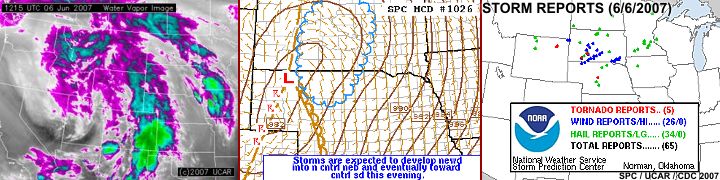
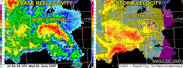
1). June 6, 4:30 PM - Interception of a very severe thunderstorm and tornado southwest of Wanblee, South Dakota near Shannon County from Highway 44. The storm was a supercell storm that originally began as a classic supercell then evolved to HP mode and subsequent bow echo (intense multicell cluster) there-after. This storm produced a long lived dusty tube type tornado in Shannon County at around 4:30 PM MDT. The latter cycle of this tornado was observed from near Wanblee at a distance of 10-15 miles. The supercell storm occluded and a new mesocyclone developed to the east of the previous (tornadic) one but only produced some funnel clouds. The storm evolved to HP, and produced another barely-visible rain-wrapped tornado southwest of Kadoka, SD before the storm quickly evolved to a bow-echo structure. Both tornadoes occurred over un-populated areas so damage was not observable. The cores of the supercell / bow were not penetrated but winds exceeding 70-MPH and hail up to 1" was encountered on the fringes of the storm. Damage observed was to trees and powerlines, and included a semi-truck blown over in Interstate 90 near Murdo, South Dakota. Conditions producing the storms were a strong low-pressure system, dryline / boundary interactions, surface heating, intense upper-level system / jet stream aloft, and possible up-slope (southeast) wind flow. Documentation was still digital pictures, HD video, and SD video. A 2007 Ford Focus was used to chase the storms. A PDS Tornado Watch was also valid for this area until 11 PM CDT (10 PM MDT).
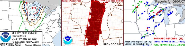
2). June 7, 3:30 PM - External observation of a very severe and tornadic developing supercell thunderstorm from Interstate 90 in eastern Minnesota (northeast of Rochester and northwest of Winona). This developing storm was observed from a distance of about 15 miles at it's point of closest approach and was not penetrated. Viewing the rear-flank of this highly-sheared storm, a well-defined rear flank downdraft (RFD) clear slot was noted along with a large funnel / tornado like lowering. This is also the same storm that produced tornado damage near Ried, Wisconsin a couple of hours later. Conditions producing this storm were a strong low pressure system and attendant dryline, surface heating, very strong winds / jet stream aloft, and abundant moisture. Documentation was still digital photos. A 2007 Ford Focus was used to chase the storms. A PDS tornado watch was also valid for this area until 12 AM CDT.
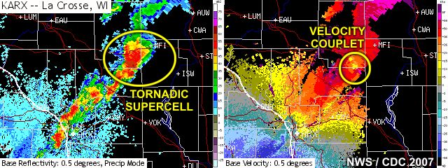
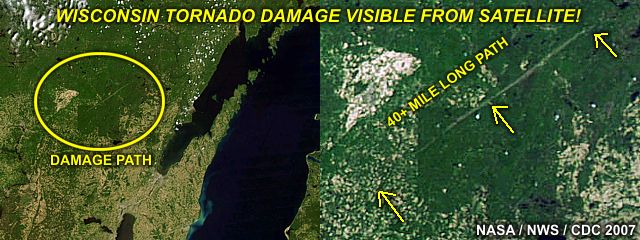
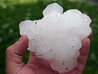
3). June 7, 5:00 PM - Interception and observation of an extremely severe and tornadic thunderstorm from Lacross, Wisconsin northeastward into Wisconsin Rapids along and near highway 173. This storm was a violent supercell (classic) thunderstorm that produced a tornado that struck part of Wisconsin Rapids and affected the area with hail exceeding 4 inches in diameter. The tornado from this storm was observed from a distance of 10 miles, behind an impressive and large RFD clear-slot on the rear-flank of this supercell. This storm was moving northeast at over 60-MPH, so getting "ahead" of it was not an option. Fortunate to the fact that hail exceeding 4" in diameter, although partially melted, was found covering the ground on the southwest side of Wisconsin Rapids. Damage from this hail was extensive, including many cars damaged or destroyed, holes punched in roofs, many trees stripped of leaves and twigs, and even deep craters left in the ground. The largest "gorilla" hail was set at 4.25" (a bit larger than a grapefruit or softball). The tornado path was not observed but was just east of where the largest hail feel. Trees and powerlines down were also encountered with power knocked out. Conditions producing this storm were a strong low pressure system and attendant dryline, surface heating, very strong winds / jet stream aloft, and abundant moisture. Documentation was still digital photos and HD video. A 2007 Ford Focus was used to chase the storms. A PDS tornado watch was also valid for this area until 12 AM CDT.
4). June 7, 10:00 PM - Interception and observation of another severe and possibly tornadic thunderstorm just west of Interstate 39 near the town of Rochelle, Illinois. This storm appeared to be on the leading edge of a cluster of severe thunderstorms earlier moving eastward out of eastern Iowa. The main focus on this storm was lightning photography, but interesting banding and "stacked plate" structure of the storm was revealed by lightning and digital camera time exposures. The storm appeared to be a small classic supercell storm, and a funnel cloud / possible brief tornado was observed (via time-exposure photography) illuminated by both lightning and the lights from nearby Rochelle. This "area" passed to our north and an RFD (rear-flank downdraft) hooked around it, with small hail and winds over 50-MPH. Later analysis of the imagery from this storm revealed a mesocyclone was indeed present and a tornado / funnel cloud clearly presented in time-exposure images. Conditions producing this storm were a strong low pressure system and attendant dryline, surface heating, very strong winds / jet stream aloft, and abundant moisture. Documentation was still digital photos and HD video. A 2007 Ford Focus was used to chase the storms. A PDS tornado watch was also valid for this area until 12 AM CDT.
This concludes the Chase Log for the northern US Plains and Midwest tornado chase trip from June 5 through June 10, 2007. The summary includes a total of 4 severe thunderstorms, all of which produced tornadoes or funnel clouds. A total of 5 tornadoes were observed, two of which were confirmed. The main chase vehicle conducting all chases was a 2007 Ford Focus. This information was prepared exclusively for the National Weather service and the team of Skywarn storm spotters.
|
This is a picture of a motel parking lot in Valentine, Nebraska during the early afternoon of June 6, 2007. Several chase teams have "just happened" to meet here from miles around since this was a major stopping point within a chase target area. Chasers call this a "chaser convergence". In this picture, Jim Reed, Verne Carlson, Amos Magliocco, and Eric Nguyen are amongst others talking about where to go next (preferably to the northwest into South Dakota). |
|
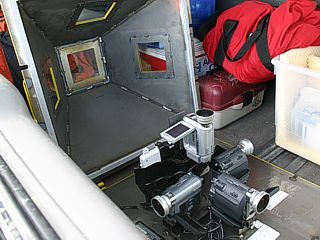
A Japanese TV documentary group who was chasing with Verne Carlson and his son Michael left this in the back of their chase vehicle. This is a tornado video probe containing 4 cameras (three looking left, right, and front, and one looking straight up. The entire unit is housed in a bullet-proof steel enclosure and each window is bullet proof glass. The cameras run off a common power supply in addition to their own batteries. Verne has yet to deploy this gadget in the elusive path of a tornado, but the Japanese crew was nice enough to foot his expenses to do so (paid for his gas, lodging, etc). |
|
While heading northward on Highway 83 in South Dakota, a developing supercell thunderstorm appears on the horizon. This shot is highly zoomed in, as the storm is over 50 miles away. Chasers call this single storm that develops in a target area a "beacon", as it attracts storm chasers anywhere in sight of it for many miles around. The ultimate chaser "convergence" often will occur when storm chasers reach this storm - Turning rural roads into traffic jams of storm chaser caravans! This is the storm that will eventually grow and produce a tornado in Shannon County, South Dakota. The view is to the west. |

|
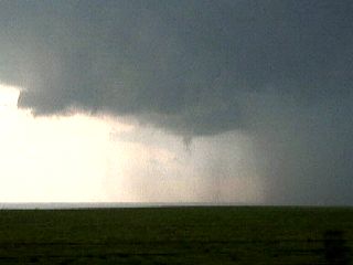
A dusty rope tornado appears under the base of the supercell storm in Shannon County, South Dakota. This tornado is about 10-15 miles southwest of the town of Wanblee in the Pine Indian Reservation, and is being viewed from a hilltop. This tornado lasted about 25 minutes, and moved slowly despite insane upper level windflow. This picture was taken at the last 5 minutes or so before the tornado lifted. The view is to the southwest. |
|
This is the same picture of the tornado above, but with the region of interest highly contrasted for a better view of the tornado on the ground. |
|
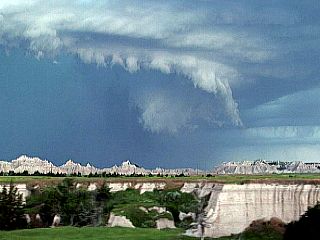
Impressive banding and lowering appears with the low-level mesocyclone of the supercell moving towards Wanblee, South Dakota. This picture shows the wall cloud (evolving to an RFD shelf cloud) as the mesocyclone that produced the Shannon County tornado occluded. Note the RFD clear slot wrapping completely around the mesocyclone and coming into the upper left side of the picture. A new mesocyclone is forming to the left. The view is southwest. |
|
Here is a closer look at the new mesocyclone that developed just to the east of the old one that produced the tornado. This cycle did not produce a tornado, but these rotating funnel clouds. The low level banding is very impressive and clearly marks the rotating portion of the supercell. The view is to the south. |
|
The RFD gust front from the first two mesocyclones occludes and cuts off the areas of rotation, and the storm becomes more precipitation-efficient, making it evolve from a classic supercell to an HP (high precipitation) supercell storm. This is a view of the RFD gust front, now with a precipitation core behind it, pushing out and forming a "notch" where a new mesocyclone is developing. The "notch" area is behind the lowering to the right. The view is to the west and northwest. |
|
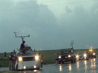
The tornado intercept vehicle (TIV) drives by as other storm chasers watch the storm evolution near Wanblee, South Dakota along Highway 44. The normally desolate regions of South Dakota's badlands became a congested arena for many storm chaser vehicles, many from bonafide research groups as well. |
|
This is a view of the HP supercell storm from Highway 44 southwest of Kadoka, SD. At this time the storm was producing a tornado wrapped in precipitation (you can barely make out its silhouette hidden behind the intense rain hook). The view is to the west-northwest at the "notch" of the HP supercell. The canyons and buttes in the foreground is South Dakota's badlands. |
|
This is Highway 44 through South Dakota's badlands with a line of chasers. The DOW (Doppler On Wheels) vehicle is in the front scanning the tornadic HP storm southwest of Kadoka, SD. |
|
While racing eastward out of Kadoka, SD on Interstate 90, the storm gust front blasts outwards producing winds well over 70-MPH. This is a view to the south on what the shelf cloud looked like as it was keeping up with my vehicle. The storm at this point has evolved from an HP supercell to what is known as a "bow echo" as it takes a "bow shape" on weather radar. A forward flank "funnel" can also be seen on the lower-right side of this picture. |
|
Here is another view of the leading edge of the intense bow segment near Murdo, SD from along Interstate 90. A forward-flank mesocyclone is to the lower-left side of this picture and has caused a "kink" in the gust front and shelf cloud. This picture is not contrast-enhanced, this is actually what the storm looked like visually. The view is to the northwest. |
|
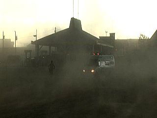
Here is the gust front and outflow winds hitting a truck-stop near Murdo, SD and just north of Interstate 90. Winds over 70-MPH, preceding the precipitation core, kick up lots of dust. |
|
This is a tractor-trailer semi that has been blown over by the violent outflow winds and is lying on its side in the median of Interstate 90 east of Murdo, South Dakota. |
|
The dryline is a boundary between warm moist air and warm dry air in response to downslope flow in the central US just east of the Rocky Mountains near surface low pressure. This is often accompanied by a wind shift from SE to SW and a sharp drop in dewpoint (humidity) as the dryline passes. Storms often develop ahead of such a boundary. In this picture, looking west, the dryline is clearly marked by a "stop" in the foreground clouds. Behind the dryline, in the warm and much drier air, dust is often kicked up and can be seen to the right. |
|
An impressive display of mammatus clouds appears at sunset behind an MCS of strong and severe storms pushing through north-central Nebraska. These clouds are not tornado-producers by themselves, but present extreme turbulence aloft. |
|
This is a video frame capture of some cloud-to-cloud lightning (CC) on the backside of the MCS pushing through north-central Nebraska. |
|
Heading east on Interstate 90 through southern Minnesota, the initiation of strong and severe thunderstorms appears as a large buildup of cumulus clouds to our east. This was the high-risk day where tornadic supercells developed into Wisconsin. Chase partner Tony Laubach is in the vehicle ahead of me. |
|
The storms quicky become severe and organize into a line segment just ahead of the surface dryline, which has now punched its away all the way into eastern Minnesota! The view is to the southeast, and a large supercell storm can be seen to the right, on the southern end of the line (called a "tail-end charley" storm). |
|
While crossing the dryline boundary from west to east in eastern Minnesota along I-90, the sudden shift of wind from southwest to southeast is so rapid that dust is kicked up on the backside of the dryline boundary. The surface dewpoint also went from 42 degrees F to 72 degrees F in only 10-15 miles of eastward progression across the dryline boundary. Very impressive for this far east. |
|
Here is another view, looking west, of the dryline boundary in eastern Minnesota. The moisture decreases as you progress westward, and the line of cumulus in the upper part of the picture "stops" at the dryline boundary itself. |
|
A highly sheared supercell storm develops on the backside and northwestern portion of the cluster / line segment of storms near the Minnesota / Wisconsin border. This storm will eventually separate from the line and move discretely and produce tornado damage near Ried, Wisconsin. The view here is to the north and northeast. Note the extreme tilting of the updraft due to the extreme shear. |
|
Here is another picture, looking the other direction (southeast) towards the "tail-end charley" supercell at the southern edge of the line segment. Very impressive and rock-hard cumulonimbus structure. Note the knuckes (back-sheared anvil) and overshooting top. |
|
A closer view of the highly-sheared supercell rear-flank and base north of I-90 near the Wisconsin / Minnesota border (northwest of Winona and northeast of Rochester) reveals this possible tornado / large funnel and an impressive RFD slot. This view is to the north and the possible tornado is about 15 miles, or more, away. |
|
Interesting band of extremely fast-moving low clouds behind the MCS and feeding into the storm north of Winona, Minnesota while heading east on I-90. The low-level jet stream has winds in excess of 80 knots this day from the south, while winds aloft at 300 MB were WSW at over 125 Knots. The dark sky in the background is from the anvil shadow of the storms / supercells associated with the cluster of storms entering Wisconsin. |
|
This is the beginning of the supercell storm that began near Lacross, Wisconsin and was to go on and produce extremely large hail and a tornado near Wisconsin Rapids later on. In this picture, looking northwest towards Lacrosse, a wet RFD has formed and is loaded with large hail (up to 3"). The developing tornado is not visible but should be behind the rain "hook" and just left of the center of this picture. |
|
As the storm clears Lacrosse, Wisconsin, it begins accelerating to the northeast and makes its way towards Wisconsin Rapids. The view here is to the northeast from I-90 and shows an extremely large RFD clear-slot and wall cloud / tornado on the ground behind it. |
|
Possible tornado on the ground (highy zoomed shot) while looking northeast along highway 173. This is about the same time Wisconsin Rapids, WI (10-15 miles away from where this picture was taken). was being hit with a tornado. |
|
Baseball to grapefruit sized hail is scattered across someone's front lawn southwest of Wisconsin Rapids, Wisconsin as the tornadic supercell moved through about 5 minutes earlier. At this point the chase is hosed as the storm is moving too fast to catch up with after running into downed powerlines and damage in Wisconsin Rapids. |

|
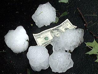
Here is a picture of myself holding large "gorilla" hailstones on the southwest side of Wisconsin Rapids, Wisconsin. Tony Laubach and I took these pictures of the hail and video was fed to CNN as well. |
|
Here is another shot of two large hailstones. The stone to the left had an odd shape and was elongated, possibly by the stones attitude (pointing in a certain direction) during free-fall from so high up. |
|
A very large (4" or more) piece of hail that is partially melted. This particular hailstone is actually made up of several smaller stones that contaced each other and stuck / froze together while at high altitude inside the supercell. |
|
Some large hailstones, still large after partial melting, compared to a $20 bill. |
|
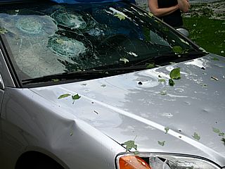
This young women's brand-new car was severely damaged by the Wisconsin Rapids hailfall. Three large shatter marks can be seen in the windshield along with numerous hail dents and a headlight destroyed. |
|
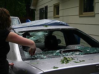
The rear window of this Wisconsin Rapids resident's car was also destroyed. The hail also fell with a horizontal "throw" (freefall drift) because of the fast motion of the supercell and strong winds in the storm's core. Many vehicles and homes had damage only on their windward facing sides. One resident had holes through his roof and water leaking into his attic! |
|
This is a crater left in the ground in a Wisconsin Rapids resident's front lawn from one of many giant hailstone impacts. The melted stone removed from the crater is just above the hole in this picture. Hail this big hitting someone can seriously injure and / or kill them. |
|
Here is a picture of another discrete supercell storm moving off into central Wisconsin at a distance of about 35 miles. The view is to the east. Also note that this supercell is undergoing a splitting phase. |
|
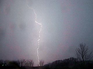
This is a digital time-exposure of two nice cloud to earth (CG) lightning strikes taken during the late evening near Rochelle, Illinois just west of Interstate 39. The storm is about 10 miles away in this picture, which is looking west. |
|
As the storm moves a bit closer, a mesocyclone develops, and CG lightning illuminates its shape and banding associated with it. This is now a small supercell storm, and is about 5 miles away. At this point, with the rear-flank of the storm about to pass over Rochelle, interest changes from shooting lightning time-exposures to worrying about possible tornado development. |
|
Sure enough, and through time exposure photography, a funnel cloud appears (center of picture) on the rear-flank part of the storm near Rochelle, Illinois. This is extremely dangerous, especially in a high-risk watch box and at night. The lights from Rochelle were enough to expose this time-exposure and reveal this dangerous feature. Shortly after, the funnel moved to our north and we got hit with the RFD / rain hook and 50-MPH winds and small hail ensued. |

|
Here is an enhanced time-exposure and close up of the funnel / possible tornado from the storm north of Rochelle, Illinois just before being hit with the RFD. |
HTML File "mwcl2007.htm" - Developed By Chris Collura
To Return To The HOME Page Of This Site Click The "INDEX.HTM" Link Here!