
| The storm chase expedition to the US Great Plains for 2003 is completed with a total of 13 travel days. Seven of these days were chase days with eleven storm interceptions. My portion of this storm chase expedition was from May 15 to May 27, with twelve days available for chasing. The main "Weathervine" storm intercept team and myself left for Dallas, Texas on May 15, 2003 and chased until May 27, 2003. This is my fourth trip dedicated to severe thunderstorm research in this area, which includes the Great Plains and the Midwestern United States. Keep in mind that this chase log is scientific evidence and portrays my on-going storm chasing research. It has been placed on this page for easy reference and meteorological interests. Please do not plagiarize or copy this document to other sites for distribution. Note - This page may take a while to load on some SLOWER connections! |
| CHASER NAME | HOME CITY | CALLSIGN | CHASE DATES | OCCUPATION |
| CHRIS COLLURA | MIRAMAR, FL | KG4PJN | 5-15 TO 5-27 | COMPUTER ANALYST |
| JASON FOSTER | BALTIMORE, MD | N3PRZ | 5-15 TO 5-27 | ARCHITECT |
| JEFF GAMMONS | WPB, FL | KG4PGA | 5-15 TO 5-27 | WEB DESIGNER |
The participants below, with the exception of Amos Magliocco, are not from the "Weathervine" chase team. These people may actively participated in our storm research efforts and deserve appreciation for their great help and severe weather expertise. Great appreciation goes to Amos, Stephen, and Doug for some incredible video of tornadoes. Amos and Stephen chased nearly the whole month of May 2003.
| CHASER NAME | HOME CITY | CALLSIGN | OCCUPATION |
| AMOS MAGLIOCCO | BLOOMINGTON, IN | KC5VPD | WRITER |
| DOUG KIESLING | MINNEAPOLIS, MN | N/A | BNVN MANAGER |
| SCOTT EUBANKS | DALLAS, TX | KC5DES | POSTAL WORKER |
| STEPHEN MILLER | MCKINNEY, TX | KD5FMI | COMPUTER PROGRAMMER |
Please note that several other chasers may caravan or "converge" with us. David Cornwell, another "Weathervine" member, could not join us this year due to some personal responsibilities.
The following entries are all storm chases and interceptions performed in the Midwest United States from May 15, 2003 to May 27, 2003. This log is based on a joint effort of a storm chasing team. Members were myself - Chris Collura (Florida Skywarn storm spotter code B036 - KG4PJN), Jeff Gammons (Florida - KG4PJA), and Jason Foster (Maryland - N3PRZ) for the main chase team. This is jointly with the Weather Information Network or "Weathervine". The main chase vehicle was a 2003 Chevy Blazer 4x4 rental SUV with a total of 5,800 miles driven during this trip.
Communications employed were HF and VHF HAM radio, FRS hand-held radios, and cellular phones and / or modems. Extensive camera and video equipment was also on board along with GPS and a laptop computer for navigation. The main chase duties were shifts in navigation using the GPS, radio communications, driving many miles, and preparing forecast data. A portable weather station also was developed by myself to be used in this chase trip. I flew into Dallas, Texas on May 15, 2003 to pick up my SUV rental and meet with Jeff and Jason arriving the same day. The chase may involved large expanses of the US Great Plains sometimes in the worst driving conditions imaginable, often in very remote regions.
All chases and observations are in chronological order and a chase number is assigned to each entry. Please bear in mind that all observations adhere to modern storm analysis standards and do not include all storms that occurred in a given area for a particular chase period. The chase log is also augmented with a small chart at the conclusion the log showing types of observations.
Any kind of storm such as a thunderstorm, tornado, waterspout, tropical cyclone, and extratropical storm can be chased or observed. I have tried to keep this log of any storms that I have observed as accurate as possible, while using terms and expressions to abide by those used by most meteorologists and storm spotters today.
Storm chasing and observation can be extremely dangerous and may result in serious injury or death. I have received intermediate and advanced training for storm spotting in 1996. I strongly urge anyone who is to try their hand at storm spotting to get training before doing so. You must also have a good understanding of meteorology and storm dynamics. "If you don't know what you're doing, Don't do it!" Contact your local National Weather Service office for information on storm spotting and about training to become a Skywarn storm Spotter. It is also advised that chasing in the Great Plains is to be done only be experienced people as a group.
May 15 - Arrived in Dallas met up with Jeff Gammons and Jason Foster and picked up rental vehicle, a Chevy Blazer SUV, and headed north on I-35 to Gainseville, Texas. Caught some very strong wind gusts west of town with power flashes and powerlines down. Winds gusted to over 60 MPH with light rain and lightning. Booked into Budget Inn and prepared vehicle with weather station and equipment. Tomorrows target set for southern OK.
May 16 - Today was a promising day with an intense upper air low, dryline, and surface-low setup. We left Gainseville and headed north on I-35 into Oklahoma, then east on 70 into the area near Antlers Oklahoma. Storms fired along the dryline and quickly became severe. One HP supercell developed NW of Antlers but was later lost to the mountainou areas to the NE. We left the cell and headed south into Arkansas on 259 / 70. Another fast-moving severe thunderstorm was penetrated between Broken Bow, OK and De Queen, AK. We finished chasing and drove back to Gainseville, TX on 82.
May 17 - Travel day. Today we left Gainseville, Texas and headed north on I-35 through Oklahoma. We stopped briefly to document the damage path from the violent tornadoes in Moore a week prior to today. We continued north into Kansas anticipating activity in Western Kansas in a few days. We stayed in Enid, Oklahoma for the night and will head for Kansas tomorrow.
May 18 - Bust day. This was a very marginal day with possible severe storms in western Kansas. We left Enid, Oklahoma and headed west into Guymon, Oklahoma. Unfortunately, we were stopped there for speeding west of town. Headed north into Kansas setting up near the Colorado border west of Tribune. Waited until past sunset but cap never broke. Only high clouds marking passage of an upper level shortwave.
May 19 - Today we had a long road trip from Garden City, Kansas with a target through central Oklahoma near the I-40 region west of I-35. We arrived in the target area and were rewarded with two beautiful supercell thunderstorms, one near Velma, Oklahoma and another near Cortney. The first storm produced strong winds and very large hail and a large, rotating wall could with funnels. The second storm was near Cortney and was a supercell for a short while. We finished with a trip back into Texas to spend the night in Mckinney, Texas.
May 20 - Today was a down day where we spent the day in Mckinney, Texas. Later this week looks more promising as yesterday did. We did witness some strong to severe thunderstorms to our west very early this morning near 4 AM. Most likely, we will head west either tonight or tomorrow for eastern New Mexico anticipating storms starting Thursday. Down time stinks, but hey, weather is weather.
May 21 - Today was a travel day. We left Mckinney, Texas before noon and headed west on 380 then to 287 through Witchita Falls. We then headed up 83 then west on 412 back to Guymon, Oklahoma for the night. There is a good possibility of storms starting tomorrow. We stopped along the way to visit a museum and ghost town outside of Wheeler, Texas.
May 22 - Today was a chase day with very marginal severe prospects. We left Guymon, Oklahoma, checked data at the public library, then headed north through Goodwell, Kansas and awaited initiation. At 7 PM, some scattered cumulus developed east of Goodwell, so we headed to the east and encountered a multi-cell cluster of thunderstorms near Studley, Kansas. Two small low level mesocyclones evolved and separated from the west side of this cluster. One became LP and low-topped with a beautiful structure before weakening. We headed back west to Goodwell and spend the night there.
May 23 - Today was another better chase day playing upslope convection in southeastern Colorado. We headed south then west and encountered our first storm north of Pueblo, Colorado. This was a photogenic severe storm with a high-base with snow capped rocky mountains as a backdrop. As the storm weakened, we headed back east and penetrated some high-based multicell severe storms near Fowler, Colorado just in time to witness a land spout. We finished chasing and spent the night in Lamar, Colorado.
May 24 - Today was a chase day starting with a long road trip from Lamar, Colorado to a primary target in the eastern Texas panhandle. The first storms to fire invlolved three small LP supercell storms near Wheeler, Texas. One of these storms became dominant and evolved into a multicell cluster. Another violent HP supercell was found on the western side of this line near Pampa, Texas which came very close to producing a tornado. The storms weakened later in the evening and we spent the night in Amarillo, Texas.
May 25 - Chase day in southeastern New Mexico. We left Amarillo, Texas and headed south through Lubbock, Texas. We then headed west through Hobbs, New Mexico to check data. Convection began farther west near Carlsbad, New Mexico near the Guadeloupe Mountains. One cell developed east of Carlsbad which became the key player in convection for the day. Convection, some thundestorms briefly supercellular were observed before evolution to an MCS. We headed south back into Texas, Passing throug Wink, then to Interstate 20. We finished and headed east to spend the night in Midland, Texas.
May 26 - Down / travel day. We left Midland, Texas around mid-day and made our way back to the Dallas / Fort Worth area to spend the next night in Irving, Texas near DFW airport. There were no storms today in our range without missing our departures tomorrow.
May 27 - Departure Day. Today was not a chase day, the day was spent packing up our gear, checking out of our hotel in Irving, Texas, turning in the rental vehicle, and flying back to Fort Lauderdale, Florida.
1). May 15, 10:30 PM - Severe thunderstorm conditions encountered west of Gainseville, Texas just west of Interstate 35. This storm was part of a cluster of severe thunderstorms, some supercells. Our storm was a weaker cell that passed just south of our location. Frequent lightning, light rain, and winds gusting to over 60 MPH. Powerlines were blown down by the storm and numerous power-flashes were observed. A 2003 Chevy Blazer was used to chase the storms. Documentation was a camcorder. The storms were caused by an upper-level disturbance, surface heating, and outflow boundary activity.
2). May 16, 4:30 PM - Observation of a severe / tornadic HP supercell type storm northwest of highway 2 between Antlers and Clayton, Oklahoma. The storm developed near the dryline boundary and southeast of an advancing surface low-pressure system with strong upper-level low. This storm was not penetrated, but a large wall cloud was observed with the storm, with 20-30 MPH inflow winds. The storm was abandoned after passing through the Kiamichi mountains. The radar-indicated tornado was not encountered with this storm. A 2003 Chevy Blazer was used to chase the storms. Documentation was a camcorder. A PDS (Particularly Dangerous Situation) tornado watch was in effect for this area until 6 PM CDT.
3). May 16, 6:00 PM - Penetration of a fast-moving severe (multicell) thunderstorm near De Queen, Arkansas along highways 259 and 70. Brief wind gusts to 60-MPH, pea to dime sized hail, torrential rains, and frequent lightning was observed as the storm was penetrated. A low-pressure system, surface heating, a strong upper-air low, and advancing dryline caused the storms. A 2003 Chevy Blazer was used to chase the storms. Documentation was a camcorder. A PDS (Particularly Dangerous Situation) tornado watch was in effect for this area until 6 PM CDT.
4). May 19, 6:30 PM - Observation and penetration of an extremely severe thunderstorm near Velma, Oklahoma. The storm was a supercell thunderstorm that developed on the south side of a line of severe thunderstorms. Very large hail was observed with this storm, around golfball sized, driven by winds over 60-MPH. The storm also produced frequent lightning and extremely heavy rains. A large rotating wall cloud was observed on the south side of the storm as it developed an inflow notch. The storm went HP, then classic, cycled mesocyclones several times, then evolved to LP with "stacked-plates" before weakening after nearly 3 hours. This storm had an incredible hail roar, and the anemometer on the Weatherlab station was broken by hail. A strong cold front, dryline, upper-level trough, and surface heating caused the storms in a sheared environment. A 2003 Chevy Blazer was used to chase the storm. Documentation was still photos, audio recording, and a camcorder. A severe thunderstorm watch was in effect for this area until 10 PM CDT.
5). May 19, 8:30 PM - Observation of another severe HP supercell type thunderstorm in Love County, Texas near Cortney just north of the Red River. This storm was a supercell storm which quickly became under-cut from outflow from the north. The storm produced vivid lightning, a large wall cloud, and 30 MPH inflow winds from our observation point. The storm core was not penetrated. A strong cold front, dryline, upper-level trough, and surface heating caused the storms in a sheared environment. A 2003 Chevy Blazer was used to chase the storm. Documentation was still photos and a camcorder. A severe thunderstorm watch was in effect for this area until 10 PM CDT.
6). May 22, 7:30 PM - Observation of a small but fully rotating LP (and low-topped) supercell storm near Studley, Kansas north of highway 24. This storm was not penetrated but assumed to be a strong thunderstorm. The storm had a tight, LP structure with low-top and rotating low-level meso with the "stacked-Plate" effect, just very small! The storm lasted for about an hour and a half after becoming detached from a multi-cell storm cluster. A 2003 Chevy Blazer was used to chase the storms. Documentation was still photos and a camcorder. Surface heating, a convergence boundary, and high speed / directional shear environment with limited moisture caused the storm. A severe thunderstorm watch was also valid for the area until 11 PM, CDT.
7). May 23, 6:00 PM - Observation of a severe high-based thunderstorm north of Pueblo, Colorado just west of Interstate 25. The storm was a multicell high-based cluster of severe thunderstorms developing near the front-range. The thunderstorms developed some rotation briefly, but quickly became outflow dominant. The storms were very striking visually. Their cores were not penetrated, but 30-MPH winds and lightning was observed on their south side. An upper level disturbance, up-slope convection, and surface heating caused the storms. A 2003 Chevy Blazer was used to chase the storms. Documentation was still photos and a camcorder. A severe thunderstorm watch was also in effect for this area until 7 PM, MDT.
8). May 23, 8:00 PM - Observation and penetration of a cluster of strong and severe thunderstorms near Fowler, Colorado near highway 10. These were high-based severe thunderstorms that produced frequent lightning, heavy rains, copious amounts of hail to 3/4", and winds near 60-MPH. The storms also produced a small landspout type tornado during an updraft phase. An upper level disturbance, outflow boundary, up-slope convection, and surface heating caused the storms. A 2003 Chevy Blazer was used to chase the storms. Documentation was still photos, audio recording, and a camcorder.
9). May 24, 5:30 PM - Observation of a small LP supercell northwest of Wheeler, Texas. The storm was part of a cluster of thunderstorms with three LP supercells! One of the three storms took superiority and evolved into a line cluster of severe thunderstorms. The call was not penetrated, but did produce hail and strong inflow (30-MPH) winds. Strong winds aloft, a outflow boundary, an upper trough, and surface heating caused the storms. Documentation was a camcorder and still photos. A 2003 Chevy Blazer was used to chase the storms. A severe thunderstorm watch was valid for the area until 9 PM, CDT.
10). May 24, 8:00 PM - Observation and penetration of an extremely severe HP supercell type storm near Pampa, Texas. This storm developed on the southwestern end of a thunderstorm cluster (tail-end charley) with an incredible and rapidly rotating structure. The storm also produced a funnel / possible tornado north of Pampa. The storm occluded and cycled as it back-built to the southwest over Pampa. During a fuel-stop, we were forced to wait out the storm under the gas station canopy. Golfball sized hail was observed with very large isolated baseball sized pieces smashing the canopy! Radar indicated a tornado with this storm the whole time, but only a low, rotating wall cloud with funnels was observed. When hail sized became acceptable, we continued south on highway 70 to get ahead of the storm, which evolved back to a multicell cluster. Torrentail rains, frequent lightning, and 60-MPH winds were also observed with these storms. Strong winds aloft, a outflow boundary, an upper trough, and surface heating caused the storms. Documentation was a camcorder, audio recording, and still photos. A 2003 Chevy Blazer was used to chase the storms. A severe thunderstorm watch was valid for the area until 9 PM, CDT.
11). May 25, 7:30 PM - Observation of severe thunderstorms near Carlesbad, New Mexico and farther to the east and southeast. Initial development just east of Carlsbad quickly became severe. The storm was not directly penetrated, but hail to one half inch, 30-MPH winds, and heavy rains was observed on its northern side along highway 62. The storm briefly evolved to HP supercell mode producing copious amounts of large hail and some small funnels. The storm quickly evolved to an outflow dominant MCS thereafter. Documentation was a camcorder and still photos. A 2003 Chevy Blazer was used to chase the storms. The storms were caused by upslope winds, surface heating, and an upper-air disturbance. A severe thunderstorm watch was valid for the area until 11 PM, CDT.
This concludes the Midwestern United States Chase Log. The summary includes a total of 10 severe thunderstorms, 1 strong thunderstorm, a funnel cloud / possible tornado, and 1 well-documented landspout type tornado (both tornadoes most likely F0 rating). The main chase vehicle conducting all chases was a 2003 Chevy Blazer. Two other vehicles were used in some chases, a 2003 Toyota 4-Runner (Amos Magliocco) and a 2002 Chevy Suburbin (Scott Eubanks). This information was prepared exclusively for the National Weather service and the team of Skywarn storm spotters.
|
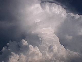
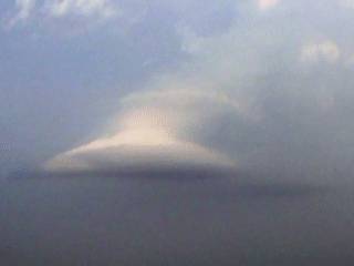
This is a picture of a strong thunderstorm's updraft side viewed while flying over Florida Everglades en-route to Dallas, Texas. The storm here is being viewed from an altitude of about 15,000 Feet. |
|
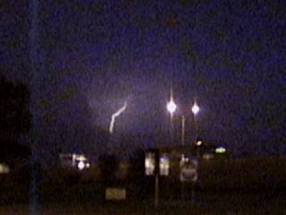
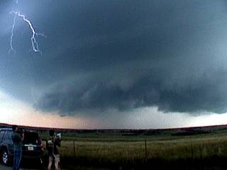
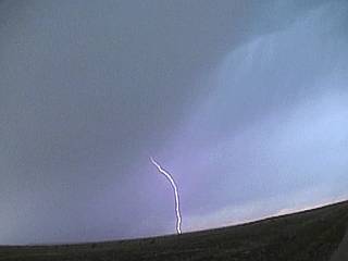
South of Gainseville, Texas, a bolt of lightning flashes over the horizon ahead of an approaching MCS of strong and severe thunderstorms. |
|
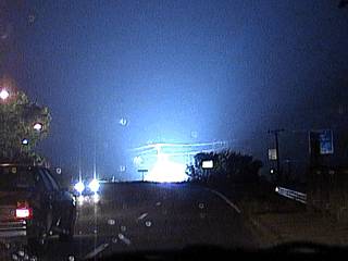
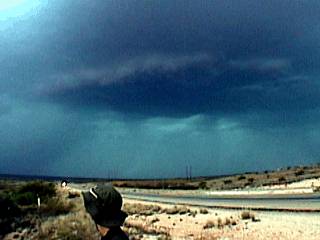
Just west of Gainseville, Texas, power flashes light up the sky just west of Interstate 35. |
|
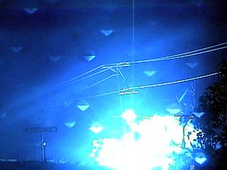
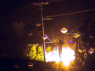
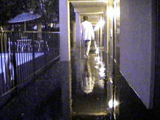
Here is a shot of a brilliant explosion as a high voltage line comes crashing down and contacts the earth and other metal objects. Winds here were gusting over 60 MPH at this time just west of Interstate 35 near Gainseville, Texas. |
|
Here is another shot of the same powerline a few seconds later sparking on the ground causing an electrical fire along the side of the road west of Interstate 35 near Gainseville, Texas. |
|
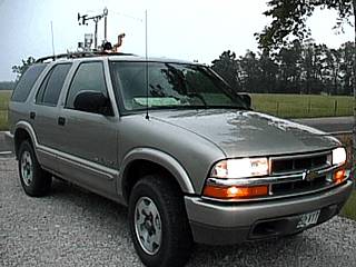
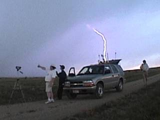
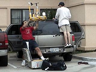
This is a picture of the 2003 Chevy Blazer SUV with the Weatherlab II equipment installed. The 4x4 rental vehicle here is parked in field in southeastern Oklahoma while waiting for storms. |
|
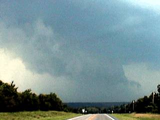
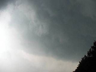
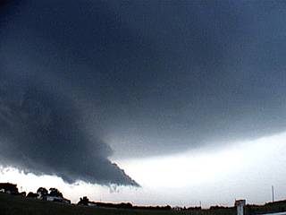
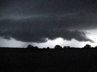
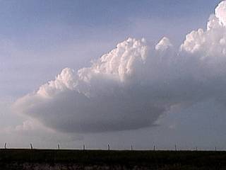
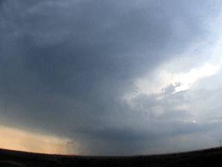
A wall cloud materializes from scud on the updraft side of a developing severe thunderstorm northwest of Antlers, Oklahoma on May 16, 2003. |
|
A large wall cloud appears on the same storm northwest of Antlers, Oklahoma on May 16, 2003. This wall cloud was part of a now HP supercell storm moving northeast into the mountainous terrain in SE Oklahoma. |
|
This picture shows the updraft base of a severe thunderstorm near De Queen, Arkansas on May 16, 2003. Here a small low-level mesocyclone develops (note the tiny clear-slot to the upper-left side of the picture). |
|
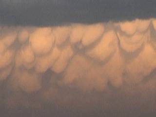
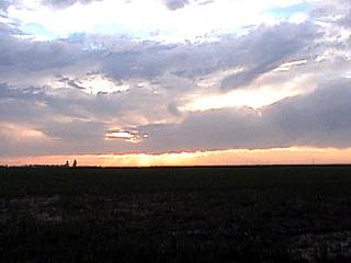
Looking back at the departing storms to the east from NE Texas along highway 82, a beautiful mammatus display appears in the setting sun. |
|
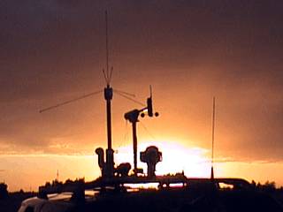
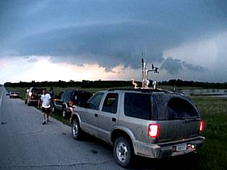
This is a picture of the Weatherlab II mounted atop the Chevy Blazer SUV with a sunset in the background. Note how the clouds "stop" in the background giving way to clear skies to the west - That's the dryline. Dewpoints ahead of the dryline were up to 73 degrees F, behind it, only 50. |
|
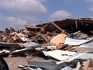
This picture shows F-4 tornado destruction in Moore, Oklahoma near I-35. These are some workshops and warehouse completely devastated by the tornado just a week earlier. Fortunately, no one was killed in the tornado due to timely warnings. |
|
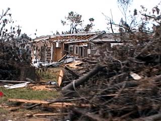
Following the damage path to the northeast, the tornado damage continues into the residential areas. In this picture, a roof is missing on a severely damaged home with large trees uprooted and lying in the foreground. |
|
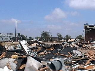
The industrial section northeast of Moore's residential area also suffered major damage. Here we see a completely demolished workshop from an F-4 tornado. Winds in this tornado were around 250-MPH. |
|
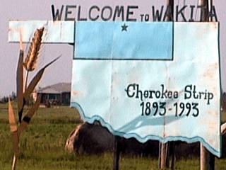
Enroute to Enid, Oklahoma, we take a quick stop in Wakita, Oklahoma. This is a very small town but gained popularity after the filming of the movie "Twister" back in 1996. |
|
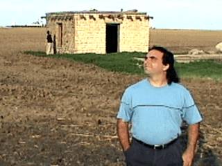
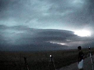
This picture shows myself standing just west of the Kansas and Colorado border watching the sky and waiting patiently for the cap to show signs of breaking. It never broke and it became clear we were all experiencing a "cap bust". Note the building in the background. This was a building from the turn of the century and is on the Kansas side. I am standing on the Colorado side. Also, the central and mountain time zones, an hour apart, are in Kansas and Colorado, respectively. |
|
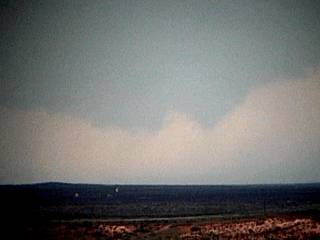
In this picture, high clouds and some high-based showers loom in the western sky over Colorado on May 18, 2003. These clouds are associated with an upper-level disturbance, but a strong cap and lack of low-level moisture prevented any deeper convection. |
|
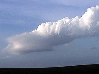
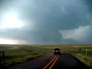
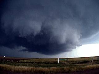
This is a picture of a developing supercell thunderstorm on the SW side of a line of severe thunderstorms. This storm is near Velma, Oklahoma and is developing a small wall cloud / funnel on May 19, 2003. |
|
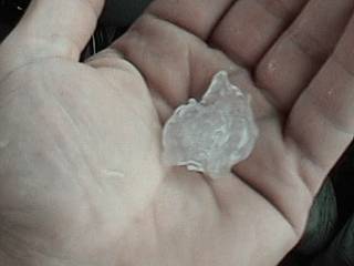
The supercell near Velma, Oklahoma begins dropping quarter to golfball sized hail. In this picture, I am holding a quarter-sized piece of hail. The storm produced an incredible hail roar and packed 60-MPH+ winds near its core. |
|
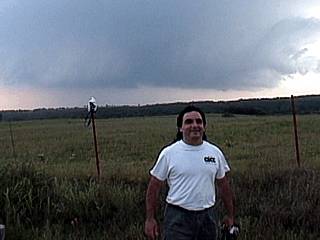
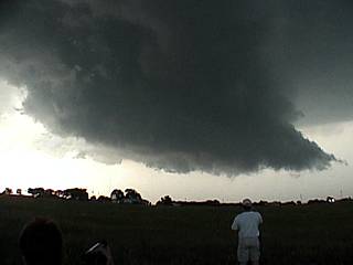
The supercell near Velma, Oklahoma becomes better organized and develops a larger wall cloud and RFD slot. I am standing in the foreground. |
|
As our chase team watches, the supercell develops and RFD gust front as lightning strikes through the mesocyclone overhead. The storm is rotating hard at this point. |
|
This is another video capture of the same supercell nearing the end of its lifecycle. It has evolved to a smaller but tight mesocyclone taking a "stacked plate" appearance resembling a "flying saucer" easily seen in this picture. The cars in the foreground are the storm chasers. |
|
This is a picture of the "stacked plates" or "flying saucers" effect storm chasers use to describe a tight mesocyclone like the one in this picture. This supercell weakened by simply getting smaller until the storm was no more. |
|
This is the vault region of the supercell near Velma, Oklahoma. The trancelucent precipitation is very large hail. Note the curved appearance of the storm's mesocyclone. |
|
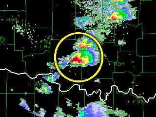
Several minutes later, as the storm undergoes another "cycle", a nice inflow tail (point) develops on the eastern side of the wall cloud. Note the striations in the upper portion of the cloud tiers in the upper-right. This storm was tagged tornadic by doppler radar. |
|
About the same time these pictures were being taken, this is a radar image of the base-reflectivity of the storm. Note the "hook" shaped "flying eagle" feature. |
|
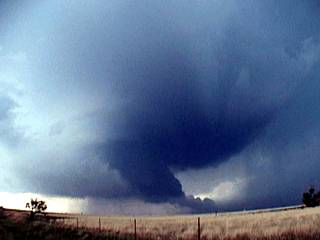
A large wall cloud develops on the supercell near Velma, Oklahoma during its peak intensity. Note the storm chasers in the foreground. |
|
This picture shows a clear slot in the supercell base caused by the rear-flank downdraft, or RFD, which is cool dry sinking air wrapping in behind the storm's mesocyclone. It sometimes, but not always, triggers tornado formation. The mesocyclone core is to the right of the center of this picture. |
|
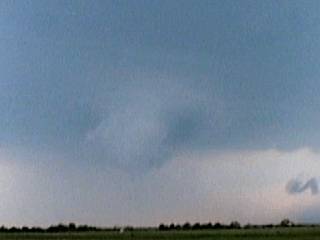
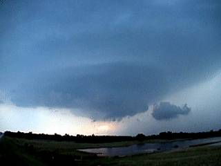
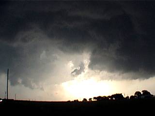
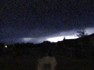
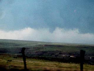
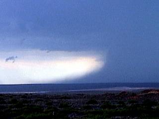
This is a poor-light video capture of another short-lived supercell thunderstorm near Cortney, Oklahoma. This storm was strong for a short while with a mesocyclone, but quickly became undercut by cooler air from the dissapating storms to the north. In this picture, a wall cloud is evolving to a shelf cloud as the storm becomes outflow dominant. |
|
This is a video-capture of some lightning to our west in Mckinney, Texas as a line of strong and severe thunderstorms passed through from 3 to 4 AM on May 20, 2003. The remainder of the day was light rain and not a chase day. |
|
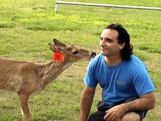
This is a picture of myself with a tame buck deer in an old ghost town west of Wheeler, Texas. We stopped at a museum and deserted town of Mobeetie on the way to Oklahoma on the travel day. The deer is tagged by rangers with a number and is protected from hunters in the area. |
|
This is a picture of a small but developing low-level mesocyclone on the backside of a cluster of multi-cell thunderstorms in a high wind-shear environment (strong winds aloft) near Studley, Kansas and highway 24. Note the banding and flared-out base of the narrow rotating updraft. |
|
This is a low-topped LP supercell thunderstorm near highway 24 and Studley, Kansas. This is a very small low-level mesocyclone with nearly all the features of a full-fledged supercell, including a vault and beaver's tail. This falls into the category of a mini LP (or Zero-P) supercell. The highly sheared storm less than 30,000 feet high. |
|
This is the same low-topped LP supercell near highway 24 and Studley, Kansas undergoing weakening. LP storms die a rather un-spectaculer demise. They simply get smaller and smaller until they are no more. |

|
This is a picture of another small cumulonimbus shower east of Goodwell, Kansas with the chase vehicle and Weather station in the foreground. This small single-cell developed and matured, but never developed a mesocyclone. |
|
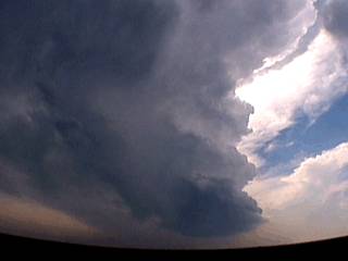
A severe thunderstorm with this amazing and photogenic structure develops rotation just north of Pueblo, Colorado near Interstate 25. These are high-based storms developing under an upper level disturbance with up-slope winds (winds blowing from the east into the mountains causing up-lift). Such storms are common in the western United States. |
|
This is another picture of the severe storm near Pueblo, colorado with a small mesocyclone. Note the round shape of the mesocyclone and small funnel right in its center despite the high base of the storm. |
|
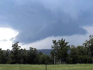
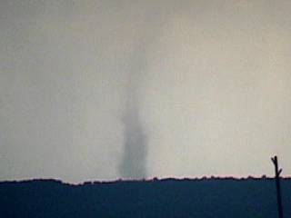
This is a picture of high-based storms developing a wall cloud southwest of Fowler, Colorado near highway 10. This storm did produce a weak tornado (landspout) during this updraft cycle. |
|
Beneath the updraft side of the high-based storms near Fowler, Colorado, a thin rotating tube develops near the ground in the center of the picture. This is a landspout, a small tornado developing beneath an updraft base of a thunderstorm. Such tornadoes are barely F0 strength. |
|
This is a video frame grab of a beautiful, forked cloud-to-ground (CG) lightning strike right in the vicinity of a developing landspout type tornado near Fowler, Colorado. The dark debris / dirt cloud is where the weak tornado is touching down just behind the ridge in the foreground. |
|
This is a closer view of the landspout developing beneath a high-based storm south and west of Fowler, Colorado. Note that the actual "touchdown" is behind the hill in the background of the picture. |
|
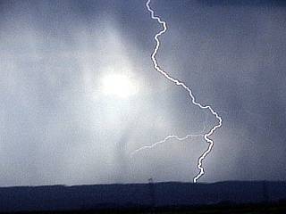
As the Weathervine storm chase team watches, a lightning bolt strikes just behind the chase vehicle southwest of Fowler, Colorado. |
|
This is another picture of cloud to ground (CG) lightning produced by the storms near Fowler, Colorado. Note the "streaks" in the sky, these are hail streaks caused by large hail falling through the cloud base. |
|
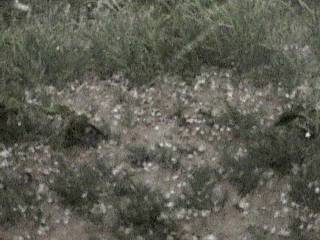
Finally, we are forced to penetrate part of the precipitation core of the high-based storms. In this picture, hail up to 3/4" covers the ground. Winds gusted near 60-MPH near the storm core. |
|
An LP, or low precipitation, supercell fires northwest of Wheeler, Texas. This storm produced large hail despite its small flared out updraft base. Note the rock-hard and majestic structure of the underside of the storm anvil and vault regions. |
|
The same LP storm near Wheeler, Texas becomes a multi-cell cluster of strong and severe thunderstorms. This picture shows a small mesocyclone on the eastern side of this storm cluster. Note the banding in the upper portions of the storm structure. |
|
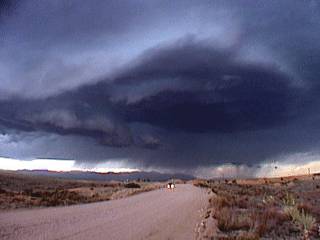
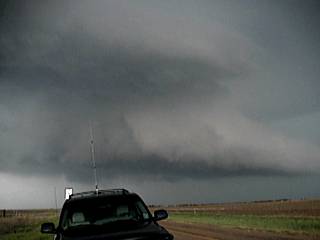
An HP, or high precipitation, supercell shows itself over a hill on the SW side of a line of severe thunderstorms. This supercell is northeast of Pampa, Texas and is called a "Tail End Charley" type storm. |
|
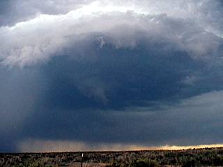
This is a more detailed picture of the HP supercell near Pampa, Texas. Note the violent rotation of the well-developed mesocyclone. Inflow into the storm is so strong that dust is picked up from the ground and sucked right up into the storms updraft. |
|
The tornadic HP supercell briefly produces a funnel cloud under its main updraft to the Nnortheast of Pampa, Texas. This was reported by spotters as a brief tornado. If you look closely at this picture, just below the funnel, you may see a faint hint of a dust whirl on the ground. |
|
This picture shows a close up of the low-level mesocyclone of the HP supercell northeast of Pampa, Texas. This area was rotating vigorously. |
|
A large wall cloud develops on the inflow side of a powerful HP supercell near Pampa, Texas during cycles in intensity. This storm was back-building to the southwest at the time. |
|
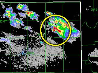
This is am image of the radar base reflectivity of the Pampa HP supercell. Although small in size, it has a tight v-notch and extremely intense precipitation core (magenta colors) at 65-70 dBz. |
|
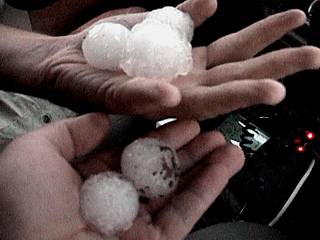
The HP supercell cycles and part of the RFD hits Pampa, Texas. Golfball sized hail falls in town and is picked up and photographed. Some stones were up to baseball sized. |
|
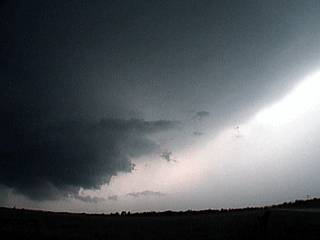
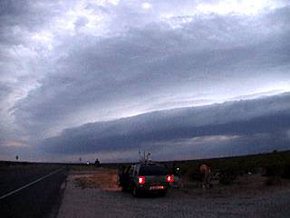
The supercell storm(s) near Pampa, Texas evolve into an MCS and move southward as an outflow-dominant storm. This picture shows a multi-tiered shelf cloud ahead of the line of thunderstorms illuminated by lightning northeast of Amarillo. |
|
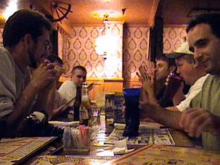
Our group of storm chasers eats at the Big Texan in Amarillo, Texas after a rather busy chase day. |
|
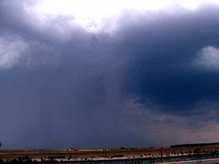
This is a picture of the initial development of a severe thunderstorm just east of Carlsbad, New Mexico. Note the darkening updraft base to the right, and hail shaft to its left. |
|
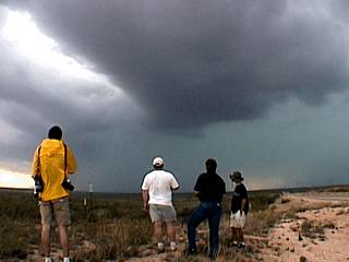
Chasers in our group watch the developing supercell storm east of Carlesbad, New Mexico long highway 62. Note the inflow bands overhead, as well as a "space" between the left and right storm splits. |
|
A rain free base develops on the left split storm just prior to storm evolution from supercell to MCS. |
|
The rain free base on the left split storm develops a wall cloud and produces the small funnels shown here in this picture. |
|
As the right split storm becomes more outflow dominant, a defined rain foot develops ahead of its precipitation core. |
|
This is a picture of a multi-tiered shelf cloud along the gust front of an MCS near Wink in Texas just south of the New Mexico border. The "curved" appearance is due to a bow segment developing within the line of thunderstorms. |
|
This is the front of the Best Western Motel in Midland, Texas during passage of the same severe MCS. The front of the rooms became flooded with about three inches of standing water. |
|
Today was spent traveling back to the Dallas / Fort Worth area early with little prospects for storms. This picture shows us dismantling the Weatherlab II weather station for our trip the next day. |
|
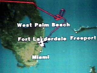
This is a view of the "passenger version" of the in-flight navigation screen sometimes displayed on the cabin monitors. Note the flight path across north-central Florida, then several over-lapping figure-8 patterns off the east coast. This was a weather holding pattern where the aircraft circles until cleared to land. The holding pattern if far offshore because the pilot is going around (not through, ofcourse) heavy thunderstorms. |
|
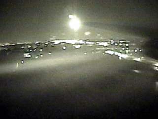
After a bumpy flight, we finally arrive, an hour late, into Fort Lauderdale Airport, concluding our trip. This picture is a video frame grab, using night-shot, out the left side of the aircraft while landing in heavy rain. Note the condensation (due to low pressure) above the wings and horizontal vortex "tubes" coming off the wing tips. |
This section is dedicated to three other chasers the "Weathervine" team and myself are involved with. Amos Magliocco is part of the "Weathervine" team and did an exceptional job along with Stephen Miller on May 15, 2003 chasing with spectacular tornado interceptions in the Texas panhandle! Doug Kiesling, of BNVN in Minneapolis also caught a beautiful tornado on May 4, 2003 in Kansas. Jeff Gammons with the "Weathervine" storm intercept team provided the nowcasting to help make it happen. Bear in mind that the video captures are NOT mine but used with permission.
|
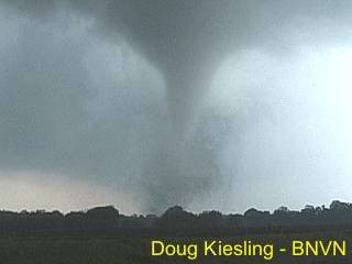
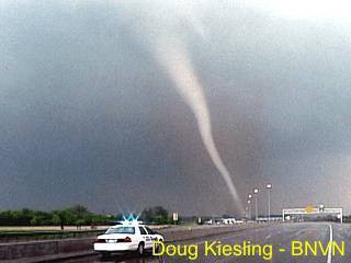
A tornado touches ground near the Kansas Turnpike on May 3, 2003 as Doug Kiesling's camera rolls. The view is to the southwest from a mere few hundred feet from the tornado's path. |
|
The tornado passes Doug, but dangerously close, and raises a debris cloud. Note the debris in the air falling around (leaves, twigs, etc.), the condensation funnel in the upper left, and the inflow jet into the right of the base of the tornado. |
|
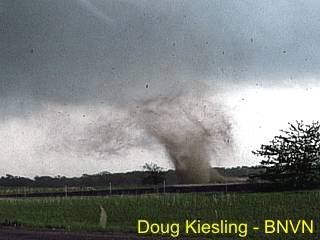
The tornado continues moving to the east and enters its rope-stage. The tornado appears white now because of the relative contrast of the darker sky behind it. Rain is beginning to wrap around the tornado, but it is still raising a debris cloud of brown dirt. Great video by Doug on May 4, 2003! |
Pictures above courtesy of Doug Kiesling, all rights reserved. More information can be found on Doug Kiesling's web site at WWW.BNVN.COM.
|
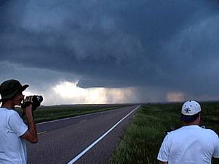
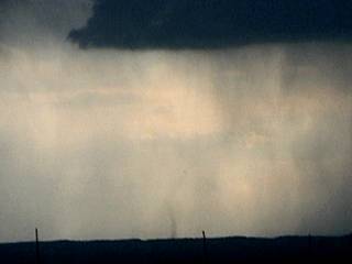
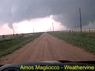
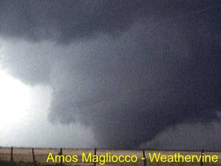
Coming up on a major tornadic supercell near Stratford, Texas. Here we see a developing wedge tornado to the right and a rope-type tornado, possibly anti-cyclonic, to the left. This is the scene most storm chasers dream about. |
|
Here is another awesome view of the wedge tornado moving to the east before becoming rain-wrapped (note RFD clear slot in foreground to the left). The tornado moves over open country near Stratford, Texas. |
|
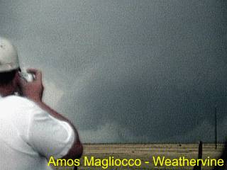
Stephen Miller steps out to take digital pictures as Amos Magliocco continues to shoot the wedge tornado as it moves off to the east over open country near Stratford, Texas on May 15, 2003. |
Pictures above courtesy of Amos Magliooco (KC5VPD) and Stephen Miller (KD5FMI), all rights reserved. More information can be found on Amos Magliocco's web site at WWW.CYCLONEROAD.COM, or Stephen Miller's site at WWW.TEXASTAILCHASER.COM.
HTML File "mwcl2003.htm" - Developed By Chris Collura
To Return To The HOME Page Of This Site Click The "INDEX.HTM" Link Here!