
| This area shows pictures taken from the interception and penetration of the circulation center of tropical storm (formerly a devastating hurricane) Mitch in the Florida Everglades during the morning of November 5, 1998. Mitch was once a devastating category 5 hurricane with 185 MPH winds and a 906 MB central pressure before making landfall in Honduras (Central America). The storm quickly weakened but caused catastropic loss of life in Nicaragua, Honduras, and Guatemala from extreme rainfall and flooding. The storm re-emerged into the SW Gulf of Mexico, regenerated from a weak depression back to a 60 MPH tropical storm, and began moving NE towards Florida. The storm made landfall once again near Marco Island and quickly crossed the state re-emerging into the Atlantic north of Palm Beach County. The storm center was penetrated from the eastern side and calm winds were found over a 20 mile wide "eye". Pictures of this tropical cyclone intercept have been posted on this page for your viewing. |
|
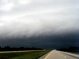
On the east side of tropical storm Mitch on November 5, 1998, heavy rains and 60 MPH winds blow from the south while headed west on Interstate 595 in western Broward County, Florida. This picture was taken about 15 to 20 miles east of the storm center and had heavy rains and strong winds from the South. This was when Mitch was crossing Florida after ravaging Central America as a major category 5 hurricane. |
|
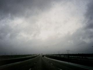
A break in the low, fast moving clouds looms over the horizon headed west on Alligator Alley in the Florida Everglades on November 5, 1998 just before entering the circulation center of tropical storm Mitch. Winds here are 60 MPH from the south with moderate rain. Tropical storm Mitch was a very deadly tropical cyclone that struck Central America a week earlier with torrential rains and 185 MPH winds. The system moved into the Gulf of Mexico and regenerated into a tropical storm before crossing Florida. |
|
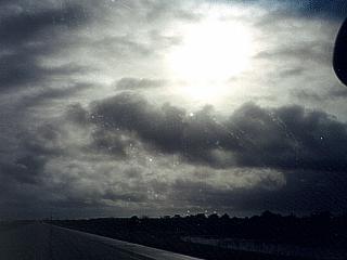
The morning sun shines over the Florida Everglades on November 5, 1998 in the circulation center of tropical storm Mitch. Partly cloudy skies and totally calm winds are surrounded by 60 MPH bands of wind and rain. This picture was taken in the center of the state west of the Seminole / Miccosukee Indian reservation along Alligator Alley. The high clouds of this infamous tropical storm filter the sunlight into the "eye" of the storm. This storm was once a devastating category 5 hurricane a week earlier off Central America. |
|
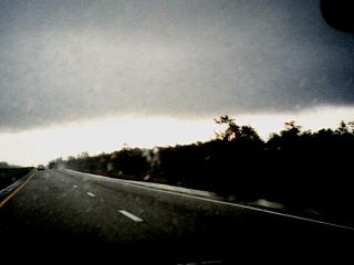
After crossing the center of tropical storm Mitch on November 5, 1998, the western boundary of the "eye" of the storm is encountered in Collier County, Florida along Alligator Alley. Winds in this area quickly went from calm to 55 MPH northerly winds with heavy rains. The calm and clearing in the centers of such storms occurs because of subsidence (sinking air) due to the "warm-cored" nature of tropical cyclones. This edge of clouds, called an eye wall in stronger tropical systems, often encircles the region of calm in the center of the storm. Mitch was a very notorious tropical cyclone because of the damage and loss of life it inflicted in Central America as a major hurricane during the end of October and beginning of November 1998. |
|
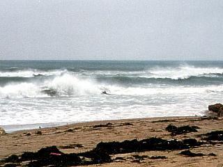
High waves affect coastal areas of Broward County, Florida on November 5, 1998. This picture was taken in Deerfield Beach and shows 5 to 8 foot waves kicked up by gale-forced southerly winds on the east side of the storm, which was in the Florida Evergaldes at the time. Mitch was a notorious tropical system responsible for death and destruction in Central America a week earlier as a hurricane. |
HTML File "mitch98.htm" - Developed By Chris Collura
To Return To The HOME Page Of This Site Click The "INDEX.HTM" Link Here!