
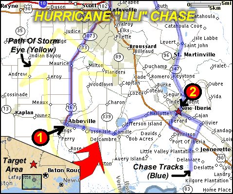
| This area shows pictures taken from the observations of hurricane Lili in Southwestern Louisiana near the Abeville and New Iberia parishes. The storm formed in the Eastern Carribean, crossed Cuba, and moved into the Gulf Of Mexico. On the evening of October 2, 2002 it moved NW and intensified to 145 MPH sustained winds in the central Gulf Of Mexico. Fortunately, the storm weakened to a 100 MPH+ hurricane while making landfall near Vermillion Bay in Louisiana. The storm packed winds over 100 MPH with violent rains during this interception on the forward-right quadrant of the hurricane. Some moderate damage and severe flooding was observed. This chase observation was also conducted with the former "Weathervine" storm intercept team as well as several other members from the University Of Louisiana Atmospheric Science Program. The chase lasted from 10:30 PM October 1 to 6 AM October 4 (actual hurricane chase was October 3), with over 2054 total miles logged! Note - This page may take a while to load on some SLOWER connections! |
| CHASER NAME | HOME CITY | CALLSIGN | OCCUPATION |
| BLAKE MICHALESKI | MONROE, LA | KD5MWK | STUDENT |
| CHRIS COLLURA | MIRAMAR, FL | KG4PJN | COMPUTER ANALYST |
| JEFF GAMMONS | WPB, FL | KG4PGA | WEB DESIGNER |
| SCOTT BLAIR | FORT SMITH, AR | KD5KOW | STUDENT |
The participants below are not from the former "Weathervine" chase team but did actively participate in our storm research efforts and deserve appreciation for their great help and severe weather expertise.
| CHASER NAME | HOME CITY | CALLSIGN | OCCUPATION |
| ANDY TINGLER | N/A | N/A | STUDENT |
| BLAIR SCHOLL | N/A | N/A | STUDENT |
| CHRIS BANNAN | N/A | N/A | MILITARY |
| DEREK DEROCHE | N/A | N/A | STUDENT |
|
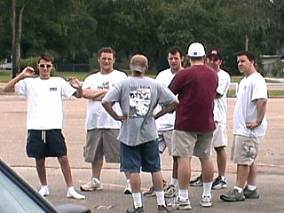
Here is a picture of the group of storm chasers that "converged" in the front of Vermillion Christian School On October 2, 2002 in Abeville Louisiana. In this picture, we see Jeff Gammons, Blake Michaleski, Scott Blair, Andy Tingler, Blair Scholl, Chris Bannan, and Derek Deroche. We are all here for the impending hurricane forecast to arrive the next day! |
|
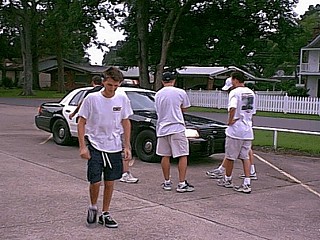
This picture shows the chasers talking to some local law enforcement about the storm to come on October 2, 2002 in Abeville, Louisiana. Local police spent a lot of time with us and were very helpful and compassionate for our chase intentions. |
|
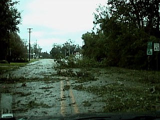
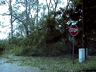
Tree debris lies strewn across the road in Abeville Louisiana on October 3, 2002 after the passage of the core of Lili near Vermillion Christian School. |
|
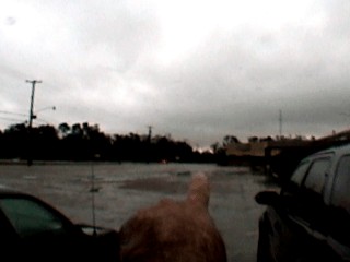
In front of the Christian High School in Abeville, LA, I point to the other chasers the clear (bright) area at the end of the roadway. This was the clear "eye" of lili passing southwest of us on October 3, 2002. Winds here were hurricane forced, but the rain has let up to a drizzle. |
|
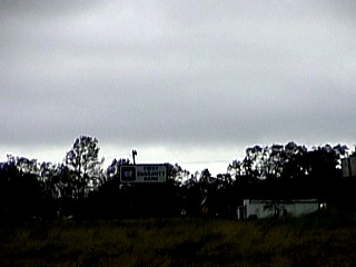
Here is another picture of the eye of hurricane Lili as it passed very close to the western portions of Abeville, Louisiana on October 3, 2002. The bright sky is the calm and sun-lit clearing inside the eye of Lili but is near the horizon because we were still in the hurricane forced winds to its east. |
|
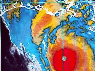
This is the screen shot of my HP laptop pulling up a satellite image of hurricane Lili at Vermillion High School in Abeville, LA during the late evening of October 2, 2002. This was when Lili had 145 MPH sustained winds. The "bag" shaped bay just ahead of the yellow colors ahead of Lili's cloud shield is not far from where we were at the time. This "direct path" view is what we call "looking down a gun-barrel"! |
|
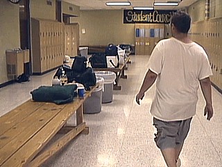
This is the inside of the side hallway of Vermillion Christian High School during the evening of October 2, 2002 in Abeville Louisiana. Blake Michaleski is in the foreground. We were given full access of this school to set up shop during our hurricane intercept through the generousity of local law enforcement as well as the care takers of the school. All gear and equipment can be seen on the bench that runs down the center of the hallway. |
|
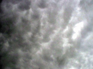
Mammatus clouds appeared just before sunset on October 2, 2002 in Abeville Louisiana as Lili approached from the southeast. The higher altitude cloud deck of Lili began interacting with a weak trough and produced an impressive mammatus field as tops of intense thunderstorms drifted to the northwest. At this time, hurricane Lili was a couple hundred miles away with 145 MPH winds. |
|
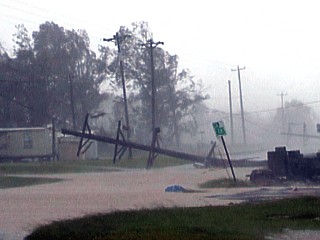
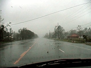
This picture shows the view up a roadway near Abeville, Louisiana on October 3, 2002 near the height of hurricane Lili. Winds over 100 MPH drop many powerlines and power poles. |
|
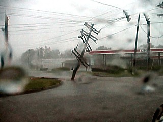
In this picture, a large power pole falls in the 100 MPH-Plus winds near the center of hurricane Lili near Abeville, Louisiana on October 3, 2002. |
|
This picture was taken just before driving into the worst winds and rain near hurricane Lili's core east of Abeville, Louisiana on October 3, 2002. In this picture, a powerline is in the process of falling right in front of the vehicle ... Sure made me stop short! Note the blowing leaves and other debris in the air. |
|
While exiting the weaker side of the hurricane, east of Abeville, Louisiana on October 3, 2002, more power poles lean and fall. |
|
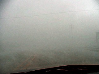
This picture shows the view out the front window while "core-punching" the eyewall of hurricane Lili east of Abeville, Louisiana on October 3, 2002. This is the so called primary energy cell (or "convective chimney") on the forward-right quadrant of the eyewall. Visibility drops to zero in violent rains whipped by winds near 110 MPH. While penetrating this convective cell, we started with southeast winds that shifted northeast, then back to southeast while driving westward (possible mesolow). Most damage in Hurricane Lili occured near this area. |
|
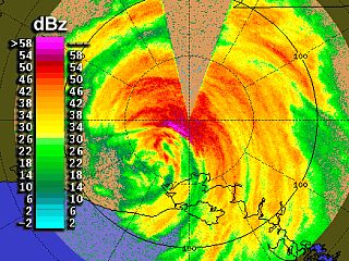
This is a radar image from one of NOAA's "smart radar" doppler on wheels chase vehicles. This image was taken shortly after we penetrated the deep conection on the northeast side of hurricane Lili on October 3, 2002 east of Abeville, Louisiana on highway 14. The DOW radar vehicle was located in Lafayette, Louisiana and clearly shows the core convection around hurricane Lili as it passes Abeville to the south and southwest. In this image, the eye is clearly visible and even has some breaks in the precipitation. To its northeast, the so called primary energy cell (convective chimney) is denoted by high reflectivities (over 58 dBz) and showing up as magenta colors. This is the cell that contains the worst (eye wall) conditions of the hurricane. Another striking feature in this image is the small red "curl" to the southwest of the deepest convection and northeast of the eye (picture is oriented so that up is north). This is a small meso-low (supercell-like) rotation that we also encountered with the penetration of the eye wall convection (we had winds that went from SE to NE, then back to SE again before entering the NE side of the eye). The "cone" of no reflectivity to the north is where the cab of the truck carrying the radar is located and the where the radar dish cannot scan the full 360 degrees. |
|
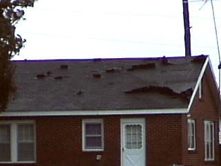
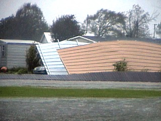
A house loses many of its roof shingles during the height of hurricane Lili east of Abeville, Louisiana on October 3, 2002. |
|
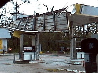
During the late morning of October 3, 2002 near Abeville, Louisiana, a gast station canopy sustains some serious damage from the passage of hurricane Lili. |
|
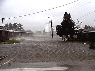
This is the view up a residential street near Abeville, Louisiana on October 3, 2002 during the height of hurricane Lili. Flooding is severe and is probably a combination of storm surge, from a nearby river backing up and / or extremely heavy rains. Winds were gusting over 100 MPH when this picture was taken. Video of this area was incredible, with flying debris and pieces of roof material landing in the flooded street. |
|
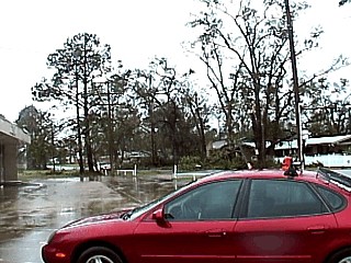
This picture shows the view in front of Vermillion High School in Abeville, Louisiana during the passage of Hurricane Lili on October 3, 2002. The vehicle in the foreground is Scott Blair's chase vehicle. Note the damage to the trees (many leaves / limbs missing). Try comparing this picture with the lush, green trees in the pictures at the top of this chase log. |
|
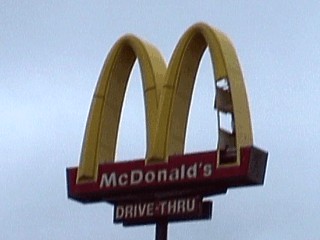
This picture shows wind damage to a Mc Donalds sign near Abeville, Louisiana after the passage of hurricane Lili on October 3, 2002. |
|
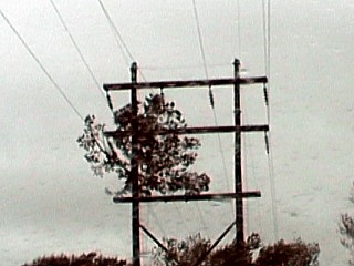
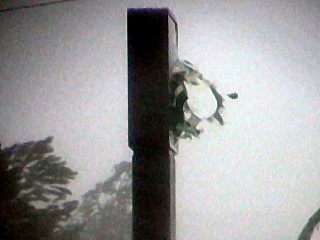
This picture shows a large portion of a tree that literally became airborne during the passage of hurricane Lili's core and came to rest high in some powerlines on October 3, 2002 near Abeville, Louisiana. |
|
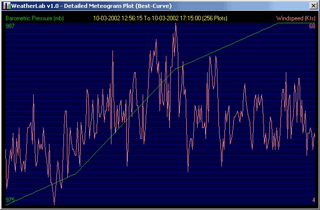
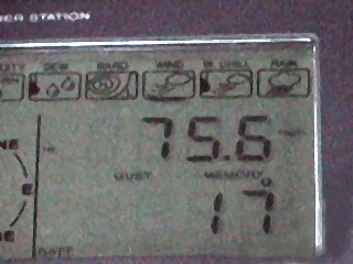
This is a picture of the wind gust display of the Oregon Scientific weather station as the beginning of hurricane forced winds were approaching New Iberia, Louisiana on October 3, 2002. While sitting in a parking lot near Lowes off Highway 14, a wind speed of 75.6 MPH was measured (74 and higher is hurricane forced). |
|
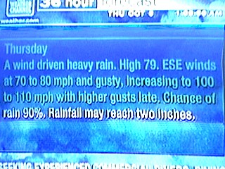
This is a picture of something you don't see very often on a Weather Channel Local forecast! After relocating from Abeville to New Iberia, Louisiana, this is the TV screen of room 110 of the New Iberia Best Western Suites. We see an east to southeast wind increasing from 80 MPH to 110 MPH (with higher gusts) on the thursday forecast! This picture was taken on October 3, 2002 near 2 AM CDT. |
|
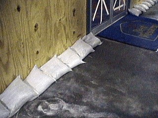
Getting ready for the arrival of hurricane Lili on October 3, 2002, windows are taped up and borded, and sandbags are placed on the main entrance of the New Iberia Best Western off highway 14 in New Iberia, Louisiana. |
|
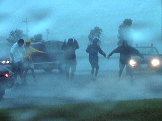
A group of hurricane chasers (Blake Michaleski, Chris Bannan, Scott Blair, and some others) stand in 80 MPH-Plus winds during the onset of hurricane forced winds in a Lowes parking lot in New Iberia, Louisiana on October 3, 2002. |
|
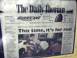
This picture shows the local newspaper front page of "The Daily Iberian" with the grim words "This Time It's For Real"! This was in front of the Best Western of New Iberia off highway 14 on the wee hours of October 3, 2002. Originally winds of 145 MPH, or higher were expected. The storm wound up weakening to 100 to 110 before coming ashore, to everyone's fortune! |
|
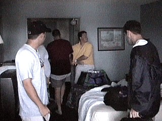
This is a view of the inside of room 110 of the New Iberia Best Western after intercepting hurricane Lili on October 3, 2002. We had a total of eight (8) storm chasers sharing this room, what a way to be cramped and split costs at the same time! The $70 hotel bill wound up being just $8 a person, but every square inch of "sleeping space" was taken up during the night of October 2-3. |
|
Major damage occurred in a mobile-home park just west of New Iberia, Louisiana during the morning of October 3, 2002. In this picture, an entire mobile home roof leans against a collapsed fence. These places are NEVER to be stayed in during a hurricane, any hurricane! |
|
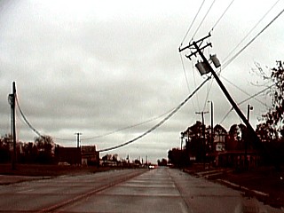
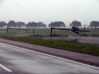
Along highway 14 just west of New Iberia, Louisiana, a row of power poles snapped during the peak of hurricane Lili on October 3, 2002. Note that these poles snapped at a right angle each about three or four feet above the base. Also note the chunk of roof tin debris in the pole to the right in this picture. |
|
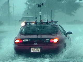
Scott Blair KD5KOW drives his chase vehicle through street flooding during the high-point of hurricane Lili in New Iberia, Louisiana on October 3, 2002. Note the equipment atop the vehicle, a 1996 Ford Taurus. The black "grill" on the rear window is a "hail shield" used for penetrating supercells in the central US plains, but now serves as a "debris shield"! |
|
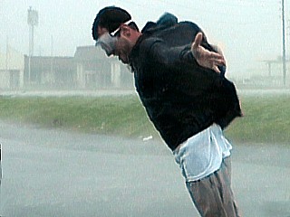
Scott Blair KD5KOW experiences his first personal touch with hurricane forced winds in the Lowes parking lot in New Iberia, Louisiana during the morning of October 3, 2002. He is wearing shop goggles to protect his eyes from the rain drops, which feel like needles at 75 MPH-Plus. |
|
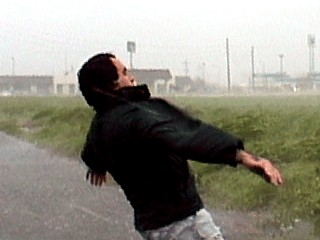
This is a picture of myself, standing backwards letting my back get "rain acupuncture" in 75 MPH-Plus winds in the Lowes parking lot in New Iberia, Louisiana on October 3, 2002. The stronger winds are still yet to come. No one can describe what this feels like, being able to lean back and have the wind "hold you up". Rain literally will leave red welts on you if winds exceed 80 MPH. Speaking of getting "wet", chase a hurricane and stand in these winds / rains and even the money in your wallet gets soaked in seconds! |
|
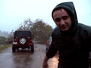
This is a picture of myself braving the onset of hurricane conditions on a small farm road about 10 miles south of New Iberia, Louisiana during the morning of October 3, 2002. Note that a tree has fallen and the road is blocked. Chris Bannan and Blake Michaleski were about to use a winch on the jeep to move the tree but law enfocement came by and told us we needed to go, and NOW! Why? Because within seconds, we saw a wall of water coming over the marshes to the east, the storm surge from Vermillion Bay! |
|
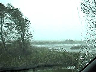
In this picture, shortly aftert heeding the authorities orders to leave the area south of New Iberia, a glance to the right reveals the rapidly moving salt waters covering the marshes and fields east of us! The water you see in the background is NOT a lake or canal, it is the storm surge from the Vermillion Bay, 10 miles to our south, infiltrating through the coastal lowlands. This picture was taken on a small farm road about 10 miles south of New Iberia, Louisiana during the morning of October 3, 2002. |
|
Hurricane forced winds literally blow a hole through a Holiday Inn sign across the street from the Lowes parking lot in New Iberia, Louisiana on October 3, 2002. |
|
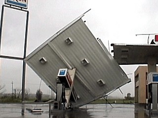
During the peak winds experienced at the Lowes parking lot in New Iberia, Louisiana on October 3, 2002, we hear a deafening "bang" from across highway 14. We found a large section of a gas station's canopy that came crashing down. |
|
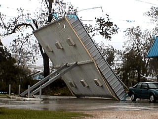
This is a picture of another toppled service station canopy to the north of New Iberia, Louisiana on October 3, 2002 after the storm. |
|
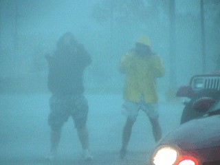
Chris Bannan and Blake Michaleski KD5MWK stand in 75 MPH-Plus winds and violent rains during the morning of October 3, 2002 in New Iberia, Louisiana at the Lowes parking lot off highway 14. The rain is so heavy that the two chasers appear to be "underwater". |
|
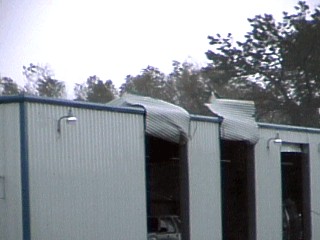
Winds gusting well over 100 MPH literally rip the corrugated roll-up doors off the bays at a storage complex as if they were paper! This was off highway 14 in western New Iberia, Louisiana on October 3, 2002. Inside the bays, lights lay broken and dangling from the ceiling. The front doors were actually "flapping" like fabric would, but this was no fabric, the doors are metal. |
|
A residential roadway is completely impassable as it is covered by tree debris and fallen trees on the northestern parishes of New Iberia, Louisiana during the late morning of October 3, 2002. This was after the worst winds of hurricane Lili passed by this area. |
HTML File "lili02.htm" - Developed By Chris Collura
To Return To The HOME Page Of This Site Click The "INDEX.HTM" Link Here!