
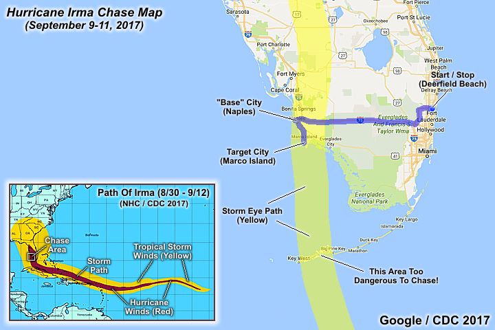
| This area shows pictures taken from the interception and observation of powerful category-four hurricane Irma in southwestern Florida mainly during its landfall in Marco Island and into Naples (Collier County). Hurricane Irma was a deadly and powerful hurricane that made its way across the Atlantic from the Cape Verde Islands off Africa in the first days of September 2017. Reaching category 5 strength, with 185 MPH winds, the storm devastated the northern Virgin Islands, passing north of Puerto Rico, then into the southeastern Bahamas. On September 9, the storm scraped across the northern Cuban coast as a category 5 storm with 160 MPH winds, then turned north and passed east of Key West with 140 MPH winds early on September 10. Later that same day, the storm made its final landfall as a strong category 3 / minimal category 4 with 125 to 130 MPH sustained winds at Marco Island. Steadily weakening thereafter, Irma continued north through Naples and east of Fort Meyers, becoming a tropical storm early on September 11 in northern Florida and Georgia. Irma finally met its end to a destructive 13-day long route from west of Africa (around Aug 30) to the USA as it became a tropical depression and dissipated over the SE USA on September 12. Irma caused extensive damage (and even catastrophic) during its journey, with several landfalls (Barbuda and British Virgin Islands, Cuba, and Florida). This chase was a "local" chase in Florida, with chaser Derek Sibley joining me. We headed out of my area in Broward County and targeted the SW Florida coast for the September 10 landfall, which would be during mid-day and ideal. We stayed at storm chaser Mark Farmer's place in Naples, helping him with boarding up and such, and joined Brett Adair, Caleb Elliott, and many other chasers (who were also in TX in Harvey) at the American Sports Pub (only place open on Sept 9) for a pre-chase party. For the interception, we chose a parking garage at a beach-front resort early on September 10, on the southern tip of Marco Island (buildings there rated for category 5 winds). The eyewall and calm eye of Irma was experienced at this location. After the storm, we went back out and worked our way out of Marco Island, observing extreme flooding and some storm surge. After checking if Mark Farmer was OK (he stayed in Naples), we left Naples and headed back east to my place in Broward County. Power was out at my place for several days, and tree damage and some roofing tiles missing. The total mileage was 292 miles. Note - This page may take a while to load on some SLOWER connections! |
| CHASER NAME | HOME CITY | CALLSIGN | OCCUPATION |
| CHRIS COLLURA | DEERFIELD BEACH, FL | KG4PJN | COMPUTER CONSULTANT |
| DEREK SIBLEY | MOBILE, AL | N/A | METEOROLOGY STUDENT |
| MARK FARMER | NAPLES, FL | N/A | IRRIGATION EQUIPMENT |
|
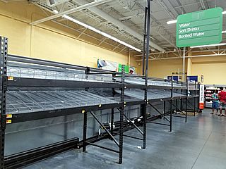
With a lengthy threat and anticipation for the impending hurricane, the shelves in most South Florida stores and supermarkets ran out of essentials long before the storm arrived. |
|
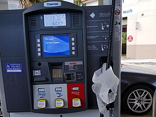
Gas station in most of South Florida did not have any fuel for many days before Irma's arrival. Here we see the all too familiar, and frustrating, signs showing no gas and the fuel pump nozzle "bagged" up. |
|
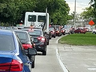
Long line of cars tieing up traffic on a normally free road in South Florida. The cars are headed to a gas station (one of only a few open) and a Home Depot hardware store. |
|
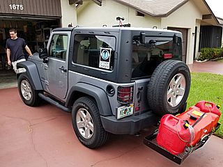
Prepring my vehicle, a 2016 Jeep Wrangler, for the chase with Derek Sibley joining me. The fuel is being carried on an external cargo rack (bent thanks to someone in a hurry hitting me a day prior) and some equipment (cameras, HAM radio antenna, and wind anemometor) are also installed on the vehicle. |
|
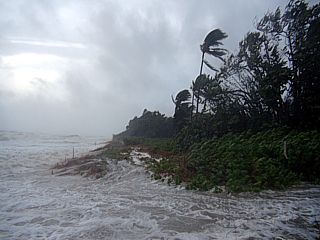
The Atlantic Ocean and high waves as tropical storm forced winds arrive on September 9, 2017 in Boca Raton / Deerfield Beach. The view is to the east. The beaches were already being closed and blocked off at this point. |
|
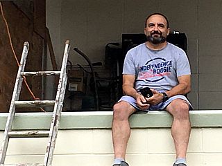
Myself taking a rest helping chaser Mark Farmer at his place bording up in Naples, Florida late on September 9. This is where Derek and I would "base" out of. |
|
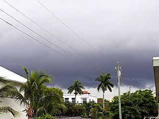
One of the first significant feeded bands from hurricane Irma approaches Naples, Florida late on September 9. The view is looking south and southeast. |
|
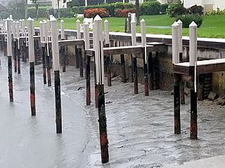
During the morning of September 10, from Naples and into Marco Island, the powerful offshore flow is pusing the waters of the Gulf of Mexico OUT to sea, resulting in a "negative surge". Marinas and docks are left high and dry and at the Gulf beaches you could actually walk great distances out on the sea floor! |
|
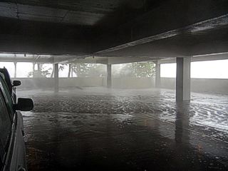
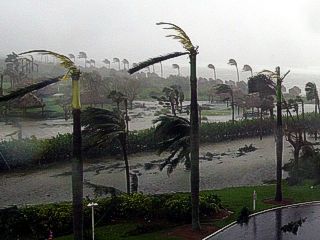
Parking garage at a beachfront resort in Marco Island. This is where we would "ride out" and observe the brunt of hurricane Irma, where it would directly hit the area later in the afternoon of September 10. Strong winds and horizontal rain are flooding the second floor of the parking structure. |
|
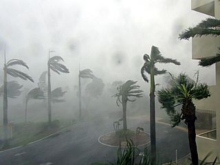
Main entrance of beachfront resort area. The eyewall of Irma has arrived, with winds gusting over 100 MPH from the east. The view is to the southwest. |
|
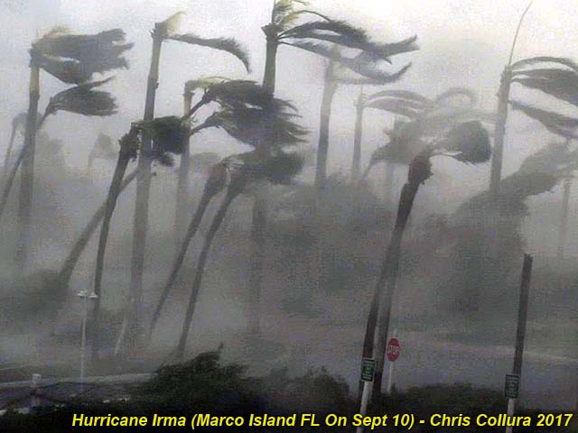
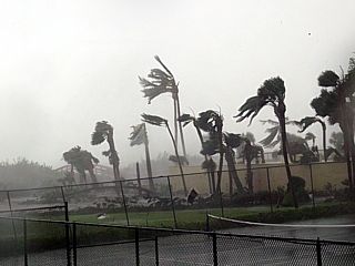
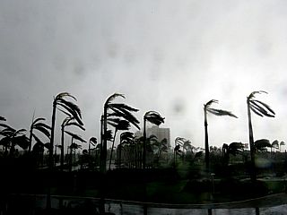
Another view of the eyewall weather in Irma tearing apart palm trees with easterly winds gusting well over 100 MPH. The view is to the south. |
|
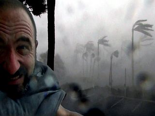
Myself wedging myself between the side and a concrete pillar during the eyewall as the wind tries to rip my clothes right off my body. |
|
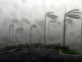
View of inner eyewall weather, with some gusts near 130 MPH, affecting the common tennis / pool area of the resort, with two large trees fallen. The view is to the west and northwest. |
|
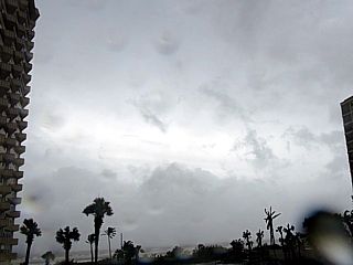
View looking towards the south and bright sky of approaching storm eye at about 3:20 PM EDT on September 10. The rain is stopping and 100 MPH+ wind gusts are starting to become more intermittant and shifting more from the southeast. |
|
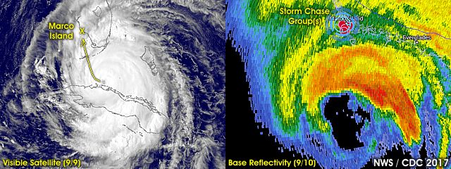
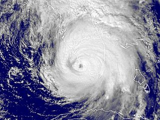
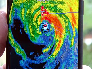
Visible satellite of hurricane Irma's final landfall in Marco Island, Florida between 3 and 3:30 PM EDT on September 10. |
|
View looking west inside the eye of Irma during nearly calm winds at about 3:30 PM. Winds became light and variable, and a minimum central pressure as low as 937 MB was measured inside the eye by Derek and I. |
|
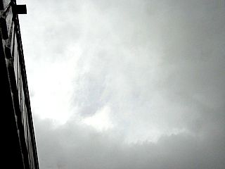
View looking up at the sun and small patch of blue sky peeking through breaks in the low level clouds in the calm eye of hurricane Irma. |
|
Radar image (base reflectivity / RadarScope app) of our GPS position inside the calm eye of hurricane Irma. |
|
Second half of hurricane Irma lasted from around and after 4:15 PM EDT. The winds shifted 180 degrees (from the west and northwest) and again gusted near 100 MPH, but the backside of the storm did not have the violent rains and was less persistant. The storm surge from the Gulf of Mexico (the view is looking to the southwest) is flooding in from right to left. |
|
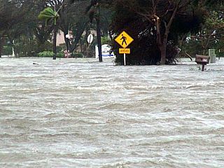
Severe street flooding in the southern portions of Marco Island late in the day on September 10. |
|
Another view of the severe street flooding in the southern portions of Marco Island caused by the storm surge late in the day on September 10. The view is looking south. |
|
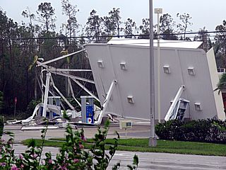
One of many damaged structures (a gas station canopy in this case) between Marco Island and Naples as the hurricne lifts northward out of the area. |
|
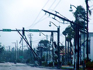
Damaged signs, trees, and power poles late in the afternoon of Semptember 10 in Naples while heading north on Highway 41. |
|
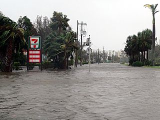
View of Gulf of Mexico and storm surge pushing on shore in Naples, Florida at arund dusk on September 10. Winds here have decreased to 45 MPH or so, with tides 5 feet or so above normal (surge was less than the feared 10 to 15 feet predicted). This hurricane surf and surge here was pushing ashore and spilling into the residential streets, causing severe flooding. The view here is to the north-northwest. |
|
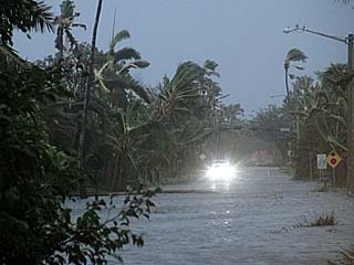
View of street leading back eastward from the beach to the residential areas of Naples near dusk on September 10. Severe street flooding was the result of storm surge and heavy rains. |
|
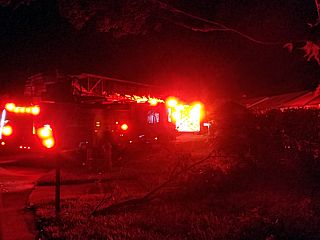
Arriving back in my area in Deerfield Beach before midnight on September 10. I am greeted with fire rescue vehicles and power knocked out in most areas. These areas were on the forward right side of hurricane Irma, with prolonged tropical storm forced winds and hurricane forced gusts, despite being 100 miles from the core of the storm. |
|
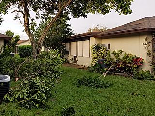
Tree damage and shingles were the main types of damage in Broward County, Florida. Morning of September 11 revealed the damages, as I retracted the hurricane shudders and helped my father / cousins clean up a bit. Power was out and we needed generators for a few days. |
|
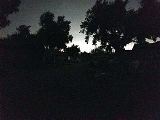
View of my street after dark in one of the largest power failures in US history lasting for days or weeks after the storm. This is during the night of September 12. The glow of the sky is from areas nearby lucky enough to have had power restored before our area. |
|
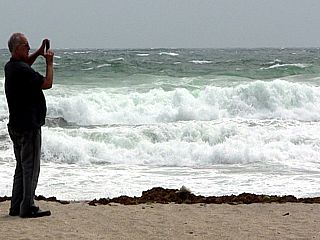
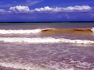
Beautiful, hot, and clear weather prevailed after the passage of hurricane Irma (photo from September 12). In this picture, residual waves and turbid (from kicked up sand and silt) give the water a sandy color. Fair weather clouds and blue skies prevail overhead as folks start the long cleanup after the storm. |
HTML File "irma17.htm" - Developed By Chris Collura
To Return To The HOME Page Of This Site Click The "INDEX.HTM" Link Here!