
| This area shows pictures taken from the interception and penetration of hurricane Irene on October 15, 1999 as it struck the Florida Keys and crossed the southern Florida Penninsula. The storm developed south of Cuba, crossing the island as a minimal hurricane. Suprisingly, the hurricane did not weaken over Cuba and passed back into the Florida Straits off Havana. The storm strengthened to 85 MPH as it crossed Key West and battered the lower Florida Keys with torrential rains and winds gusting to 104 MPH. The hurricane then crossed Florida Bay making landfall at Flamingo only to jog to the NE across the Everglades. The storm again failed to weaken over land, dumping 20 inches of rain and packing 85 MPH winds in parts of Broward, Dade, and Palm Beach counties. The chase of this storm was a very well documented chase and actually passed through all four quadrants of the storm as it was followed through the Florida Keys and then into the Florida Penninsula. The hurricane eventually re-emerged into the Atlantic off East-Central Florida and being a storm with tenacity, intensified to 105 MPH. Note - This page may take a while to load on some SLOWER connections! |

|
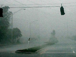
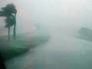
(1) This is a picture of Maraton in the Florida Keys taken about 9:15 AM on October 15, 1999. This is where the main eyewall of hurricane Irene is being penetrated. Winds here are gusting anywhere from 80 to 100 MPH with extremely violent rain while heading southbound on Highway US 1. The picture shows what driving through an eyewall looks like. |
|
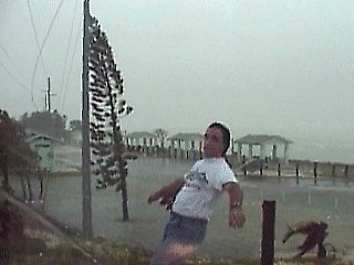
(2) This is a picture of me standing in the 75 to 80 MPH winds at the south end of Seven Mile Bridge in the Florida Keys at about 9:30 AM on October 15, 1999. The strong southeast winds support my weight as I lean into them. Note the flooding in the background from the storm surge off the ocean. This was between the eyewall and the eye itself, where the rain is light but the highest winds are found. You could hear the wind whistling in powerlines and howling when this picture was taken. |
|
(3) This is a picture of the eye of hurricane Irene at about 10:30 AM while arriving at Key West on October 15, 1999. The picture above was taken just after entering the eye of the storm along Highway US 1. The view in this picture is to the east across the eye. Note the bright "hole" in the clouds caused by the sinking air inside the storm center. Note the "stadium effect" where the eyewall surrounds the eye, as depicted by the dark grey wall just below the bright area in the center of the photo. Winds here are DEAD CALM with NO RAIN, not even a single leaf on a tree moving. |
|
(4) This is a picture of the street flooding from over 10 inches of rain in Key West at about 11:00 AM on October 15, 1999. This picture was taken while still inside the eye of hurricane Irene. Note how still the water surface as well as the trees along the road. The view is looking northward. |

|
(5) This is a picture of the storm surge and waves breaking over the southern ocean roadway in Key West at about 11:00 AM on October 15, 1999. This picture was taken inside the eye of Irene. Note the high water but lack of wind or rain. Note the bright sky in the background as the sun peeks through the clear spot in the eye of the hurricane. The view in this picture is looking northeast. |
|
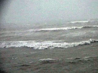
(6) This is a picture of the surf breaking off the bridge at Seven Mile Bridge in the Florida Keys while traveling northbound at about 12:00 PM on October 15, 1999. The winds here are just east of the eye and about 80 MPH. Huge waves break in the shallow water off the bridge, which is at least 25 feet above the water. Some waves actually slammed spray onto the highway at this height! Remember, it takes a lot of wind to stir up waves in the shallow water of the Florida Keys. |
|
(7) This is a picture of a parking lot completely covered by the storm surge at the north side of Seven Mile Bridge in the Florida Keys at about 12:30 PM on October 15, 1999. This picture was taken while jamming myself between a pole and a guardrail on the embankment so I would not get bowled over by the winds. Winds here were over 80 MPH with moderate rain and tides nearly six feet above normal. The view in this picture is looking towards the south. The parking lot is for a beach and fishing area to the far right, which is completely inundated by the storm surge. |
|
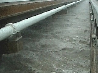
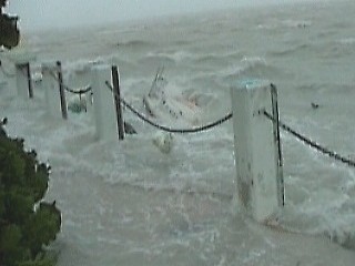
(8) This is a picture of the two bridges near Grassey Key in the Florida Keys at about 1:30 on October 15, 1999. The 80 MPH plus winds from the south and southeast push the storm surge against the ocean side of the keys. On the bay side, the winds blow offshore, so the tides are normal or even below normal. In a channel separating the two bodies of water, a torrent of ocean water rushes into the bay. In the picture above, Highway US 1 is to the left and a walkway bridge is to the right on the ocean side of the inlet. You could actually see the difference is water level as it rushes under the bridges from the ocean. Imagine someone falling into this water and being literally swept out to sea, a thought on how deadly a storm surge can be. |
|
(9) This is a picture of a boat being smashed to bits and sunk from the brute force of the hurricane winds and storm surge. This picture was taken in Marathon in the Florida Keys at about 1:00 PM on October 15, 1999. The tides here are more than five feet above normal and winds are over 80 MPH under part of the eyewall. While taking this picture, part of a roof landed just a few feet from where I was standing! |
|
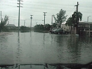
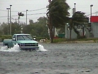
(10) This is a picture of a parking lot flooded by fresh water after the eyewall passed through Marathon in the Florida Keys at about 2:00 PM on October 15, 1999. About 10 to 20 inches of rain was dumped by this hurricane. In this picture, several feet of water covers the parking lot as a truck tries to cross. Winds here are also gusting over 60 MPH. Flooding was the main and costliest damage from Irene. |
|
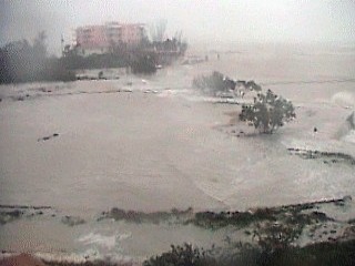
(11) This is picture of a beachfront condominium parking lot being overtaken by 80 MPH winds and storm surge. This picture is looking towards the south at the parking lot in Marathon at in the Florida Keys at about 1:15 PM on October 15, 1999. The ocean waves slam ashore sending spray many feet into the air. The storm surge also floods into the parking area and sends a stream of ocean water down the roadway. The battering waves and storm surge causes most damage along any waterfront during a hurricane. |
|
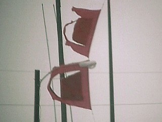
(12) This is a picture of the famous red and black hurricane warning flags at Marathon airport in the Florida Keys at around 1:30 PM on October 15, 1999. The strong 75 to 80 MPH winds tatter the flags. The view is looking to the north from Highway US 1 in Marathon. |
|
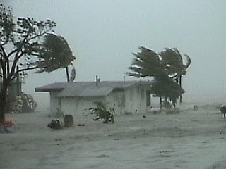
(13) This is a beachfront house being engulfed and destroyed by the storm surge. This picture was taken at about 1:30 PM on October 15, 1999 near Marathon in the Florida Keys while traveling northbound. Winds here are gusting over 80 MPH and tides are 5 feet above normal. This is all salt water from the ocean flooding in the foreground. Remember 9 out of 10 people who die in a hurricane die from such flooding. |
|
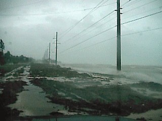
(14) This is a picture of the main Highway US 1 in the keys near mile marker 75 in the Florida Keys at about 2:00 PM on October 15, 1999 heading northbound. The winds here are about 80 MPH and the storm surge is pushing seaweed and sand across the highway. Remember, this is a HIGHWAY, not a BEACH! The beach is far to the right under many feet of water. This is the ocean literally crossing the keys and dumping into the Florida Bay to the west. You could actually see fish flopping in the highway. |
|
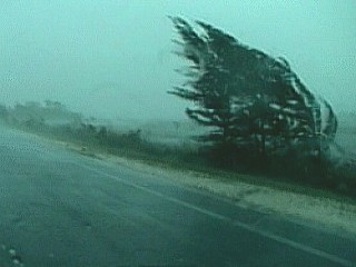
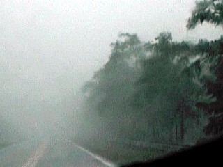
(15) This is a picture of the repenetration of the outer portions of the eyewall of hurricane Irene while traveling northbound out of Key Largo on Highway US 1. This picture was taken at about 2:45 PM on October 15, 1999 and is looking to the north. Winds here are about 70 to 75 MPH from the southeast with extremely heavy rains where a small australian pine tree thrashes in the wind. |
|
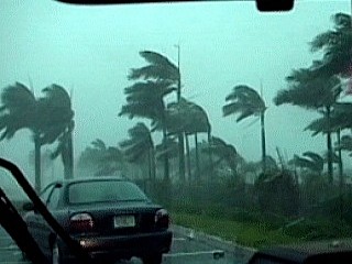
(16) This is a picture of the palm trees near the Homestead toll plaza along the Florida Turnpike at about 3:15 PM on October 15, 1999. Homestead was recieving southeast winds up to 85 MPH hour at the time. The view here is looking towards the northeast. |
|
(17) This is a picture of the Florida turnpike going through Homestead. The outer portions of the eyewall of Irene are being penetrated where winds are near 85 MPH with violent horizontal rains. This picture was taken traveling northbound at about 3:00 PM on October 15, 1999. |
|
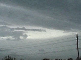
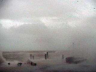
(1) This is a picture of the second penetration of Irene's eyewall along Tamiami trail in the Florida Everglades at about 5:30 PM on October 15, 1999. This picture was taken about 10 miles west of the Miccosukee Indian reservation during the second penetration of the core of hurricane Irene. Violent rain and 80 MPH plus winds buffet the chase vehicle. The winds here are quickly shifting from southeast to northeast as the storm center to the south is passed by. The storm made a secondary landfall in Flamingo about 30 miles to the south of Tamiami trail after hitting the Florida Keys. The view in this picture is towards the west. |
|
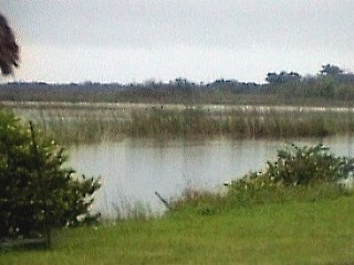
(2) This is a picture of the lulling calm in the eye of hurricane Irene during the second penetration of the storm along Tamiami Trail. This picture is looking at the perfectly calm water of the everglades at the Miccosukee Indian reservation at about 6:30 PM on October 15, 1999. The view is looking towards the northeast. A calm period like this can last up to an hour, but only means that the storm is half over. |
|
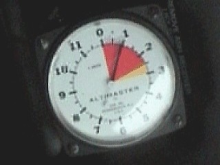
(3) This is a picture of a pressure altimeter used by skydivers. The Altimaster altimeter works by a drop in air pressure with height. In the picture above, the altimeter needle reads "1" for 1000 feet above sea level. Since this reading was currently being taken only 10 feet above sea level in the eye of Irene, the pressure indicated suggests about 982 MB. This was the lowest pressure observed during the second eye penetration along Tamiami Trail in the Miccosukee Indian reservation at about 6:30 PM on October 15, 1999. A hurricane is an area of LOW pressure, and the lowest pressures are found inside the eye. |
|
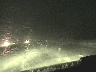
(4) This is a picture of Interstate 595 in western Broward county while the eye of hurricane Irene was about 20 miles to the west in the Florida Everglades. The winds in this picture are over 80 MPH because this was under the eastern eyewall of the storm. The Niteshot feature on the Sony camcorder allows video and pictures to be taken in total darkness. This picture was taken at about 7:30 PM on October 15, 1999 in violent rain and winds and total darkness due to the storm taking out power lines. The view is heading east along Interstate 595 using night vision. |
HTML File "irene99.htm" - Developed By Chris Collura
To Return To The HOME Page Of This Site Click The "INDEX.HTM" Link Here!