
| This area shows pictures taken from the interception and penetration of tropical storm Harvey as it made landfall on the SW Florida coast on September 21, 1999. The tropical storm came ashore with maximum winds up to 55 MPH. A large flareup of strong and severe thunderstorms was observed near the center of this storm. The storm also dumped over 10 inches of rain in Naples, Florida. Pictures from this interception have been provided in this area pertaining to TS Harvey. |
|
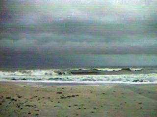
Large waves affect the shores of the Gulf Of Mexico during the morning of September 21, 1999 in Naples, Florida as tropical storm Harvey churns just offshore. Harvey had sustained winds up to 55 MPH, mainly to the SE of its poorly defined center at the time. Winds here are about 30 MPH from the SE while the view in this picture is looking SW. Note the banding in the cloud structures of the low clouds, these are called cloud "streets". |
|
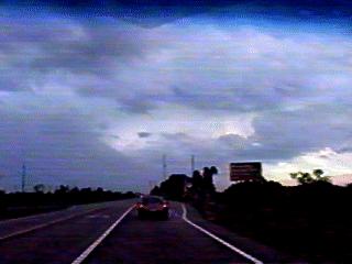
This is a picture of the core of tropical storm Harvey near Fortymile Bend along Tamiami Trail near the Miccosukee Indian reservation in Florida on September 21, 1999. This view is towards the west shortly after Harvey made landfall on the SW Florida coast. Winds here are gusting to about 50 MPH from the south (from the left in this photo). A large convective thunderstorm complex, called a primary energy cell (convective chimney) is just to the SW and contained 70 MPH plus winds and rainfall up to 20 inches! Luckily, this area rotated around the south side of the circulation center and remained over un-populated regions. The cell is visible in this picture to the left, where the northern edge of its precip core forms a rain "foot". The circulation center of Harvey, just beyond the cell's northern side, is marked by the break in the clouds to the right and center of this picture. |
|
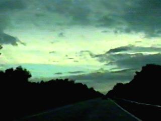
Along Tamiami trail in Collier County, Florida, the circulation center of Tropical Storm Harvey is encountered on September 21, 1999. The chase track continues to the NW across the relative calm of the storm center (leaving 55 MPH winds behind). A large convective cell also was on the southern side of the circulation center and the cirrus shield covers the entire sky. Note the blue sky to the far lower left side of the picture as well as the "yellow" appearance if the base of the cirrus shield. The yellow color is because light is filtering for great distances beneath the large "structure" of the central dense overcast. The low clouds, dark in this picture, are racing to the right. |
HTML File "harvey99.htm" - Developed By Chris Collura
To Return To The HOME Page Of This Site Click The "INDEX.HTM" Link Here!