
| This area shows pictures taken from observations of tropical storm Gordon on the Florida east coast in late November 1994. This storm contained sustained winds of 55 to 60 MPH over a large area. The storm formed in the Caribbean near Cuba and moved along an erratic path ultimatly crossing south Florida. The storm dumped heavy rains and produced gale forced winds but strengthened to a hurricane well to the northeast of Florida with 80 MPH winds. |
|
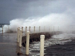
In the evening of November 20, 1994, high waves and 45 MPH northeast winds smash into the north seawall at Boynton Inlet in Boynton Beach, Florida. Waves were observed as high as 15 feet with tides 2 to 3 feet higher than normal. The waves smash over the breakwater sending spray high into the air. The view here is to the east. |
|
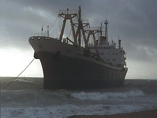
Winds from the southeast gusting over 55 MPH run a large ship aground at Fort Lauderdale Beach, Florida on November 21, 1994. The freighter ship dragged anchor and came to rest on a sandbar about 100 yards offshore in heavy seas. The view here is to the southeast. |
|
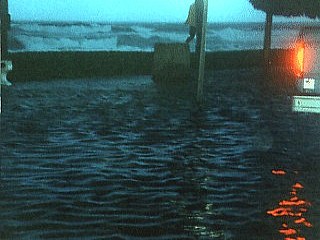
The high surf and tides flood the road along Deerfield Beach, Florida on November 21, 1994. The picture here is after the center of Gordon passed by where 50 MPH easterly winds suddenly let up. The water, pushed by the previous winds, remains high. In the picture above, tides were 2 to 3 feet above normal. The view is to the east. |

|
The circulation center or "eye" of tropical storm Gordon as it was over Palm Beach, Florida on November 21, 1994. Clouds break and blue sky becomes visible with light and variable winds in the broad center of Gordon. The view here is to the north. |
HTML File "gordon94.htm" - Developed By Chris Collura
To Return To The HOME Page Of This Site Click The "INDEX.HTM" Link Here!