
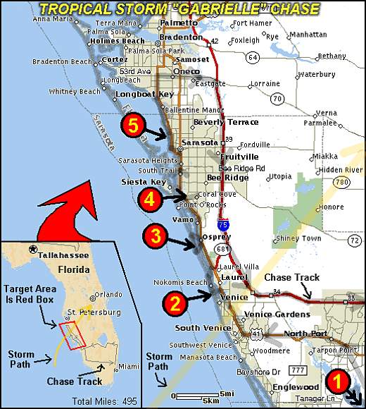
| This area shows pictures taken from the interception and penetration of tropical storm Gabrielle on the Florida West Coast on September 14, 2001. This storm formed off the SW Florida coast over the warm waters of the Gulf Of Mexico. Although slightly sheared, the storm began rapidly intensifying off West Central Florida and made landfall near Venice Inlet. The system was named a 70 MPH tropical storm but was probably an un official hurricane during the landfall time during the morning of September 14. Winds gusted over 85 MPH and a barometer reading of 983 mb was observed in this area of landfall and was very well documented with myself and the former "Weathervine" storm intercept team. A total of 495 miles was logged with this chase and employed a newly designed car-top weather station! Note - This page may take a while to load on some SLOWER connections! |
|
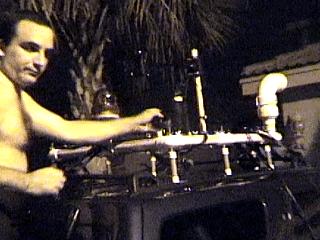
This picture was taken the night before the planned interception of Gabrielle as I was rushing the "Weatherlab" portable weather station to completion. I am finishing the hookups for the weather station mounted on the top of my 2001 Ford Escape during the evening of September 13, 2001 in front of my home in Miramar, FL. The "Weatherlab" unit can measure temperature, pressure, wind speeds, wind direction, and dewpoint to name a few. The unit is also self-powered with an emergency light as well as its own side "head lights". It even has an external color video camera and microphone. |
|
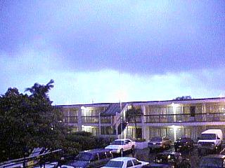
This picture shows the sky, note the large rain-free base, during the passage of a squall line and HP supercell storm during the early morning of September 14, 2001 at a motel in Fort Meyers, Florida. The HP cell and its feeder-band squall line prompted a tornado warning. The tornado was completely rain-wrapped. In this picture, a cloud to cloud lightning strike illuminates the night sky a lavender color. The color is because the lightning is occurring between clouds in the thick rain shield preceding tropical storm Gabrielle, much like anvil lightning ahead of a large MCS. Winds here gusted to 45 MPH from the SE before shifting SW and dying to 15 MPH after the passage of the band. |
|
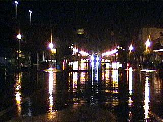
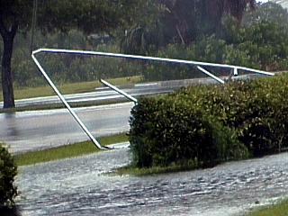
A street is flooded with fresh water during the early morning hours of September 14, 2001 in northern Lee county, Florida. Severe thunderstorms passing through the area ahead of tropical storm Gabrielle dumped 5 to 10 inches of rain in the area north of Leheigh Acres. |

|
A photogenic rainbow on the west side of a feeder band squall line is encountered headed home from a tiring and productive chase of tropical storm Gabrielle. The return from the Sarasota area back to Broward County, Florida was about three and a half hours. A dry slot behind the storm kept clear and breezy weather in place from Fort Meyers to Broward County. The dry "slot" reached the moist air to the east forming a distant squall line of showers and thunderstorms. The rain behind this line allowed a rainbow to form in the setting sun with the updraft base behind it. Winds went from SW to SSW when crossing this line from W to E, accompanied by a sharp increase in the dewpoint temperature. |
|
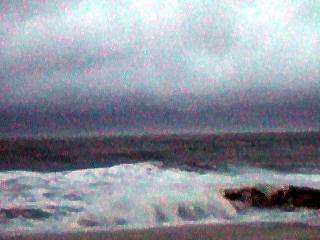
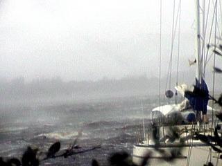
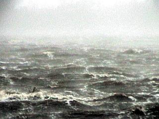
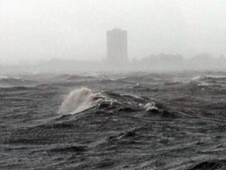
This picture was taken just prior to sunrise and the arrival of the circulation center, or "eye" of tropical storm Gabrielle north of Venice Inlet, Florida on Venice Beach on September 14, 2001. Winds here are southeast at up to 60 MPH, but are blowing off shore. The rain is letting up and the center of circulation is about 20 miles to the south of the location this picture was taken. Waves from 5 to 8 feet are coming in as a strong southwest swell ahead of the storm. What is interesting about this picture is the eyewall cloud bands just above the horizon of the Gulf of Mexico in this view to the west. Also, note the "white horizon" caused by the stronger winds whipping the sea surface a few miles offshore. |
|
During the early morning of September 14, 2001, debris from trees litters the street just north of Venice Inlet, Florida while on the northern side of the core of tropical storm Gabrielle. Winds here are southeast at 50 MPH+ and the worst is yet to come. |
|
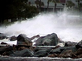
The jetty along the beach on the south side of Venice Inlet is covered by large waves inside the eye of Gabrielle during the morning of September 14, 2001. Winds here are light from the SE but tides are usually highest in the eye and around it in regions of strong on shore winds. Here, the large waves are from a heavy SW swell in advance of the tropical storm. |
|
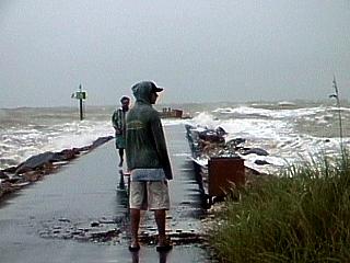
Some surfers rush to Venice Inlet, Florida during the brief calm inside the eye of tropical storm Gabrielle on September 14, 2001. People were actually surfing in the 5 to 8 foot glassy swells, very rare for the Gulf of Mexico, as the storm eye passed over with light winds from the SE. This period of calm lasted only 10 to 15 minutes and was replaced by sustained 70 MPH NW winds! Only minutes after this picture was taken, the entire jetty you see here was under water with the wind maxima of Gabrielle prevailing. The surfers luckily escaped the wrath of the second half of the storm after being told to leave by authorities. |
|
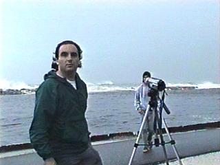
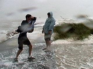
This picture shows myself standing along the north side of Venice inlet on Florida's west coast on the morning of September 14, 2001. This was in the circulation center, or "eye" of tropical storm Gabrielle. Winds here are light with no rain and the clouds in the sky are breaking with sunlight peeking through as the western side of the storm "eye" is penetrated. This picture is from video by Jeff Gammons and Dave Cornwell of the former "Weathervine" storm chase team. The video camera to the right is recording a time-lapse attempt of the high vorticity within the storm center. |
|
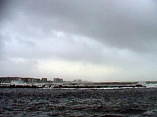
Looking south over Venice Inlet, Florida, the circulation center, or "eye" of tropical storm Gabrielle makes its appearance during sunrise on September 14, 2001. The clear area is moving to the NE at about 10-15 MPH and will pass just to the east of us. The worst winds in the storm are on the backside of this temporary calm, and are only a short wait away. Note the clouds breaking in the storm center. Winds here were under 15 MPH, and variable. |
|
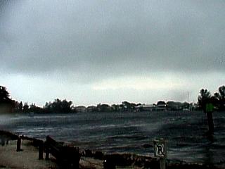
Looking east over Venice Inlet, Florida, the circulation center, or "eye" of tropical storm Gabrielle passes to our east during the morning of September 14, 2001. The storm is moving to the northeast at 10-15 MPH. In this picture, the second half of the storm is just beginning to move in. Winds here are rapidly increasing from the north and northwest as the storm center moves a bit farther away. |
|
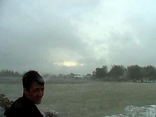
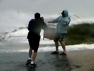
Looking east over Venice Inlet, Florida, the circulation center, or "eye" of tropical storm Gabrielle passes to our east and moves farther away during the morning of September 14, 2001. The worst winds are hitting from the NNW and are now near 70 MPH, sustained, with higher gusts. The bright skies of the storm's center still can be seen because the wind maxima of such storms occurs on the inner edge of the eye wall surrounding the storm eye. The scud clouds in this picture are racing from left to right as Jeff Gammons with the former "Weathervine" team catches his breath after getting blasted by the winds and rain. |
|
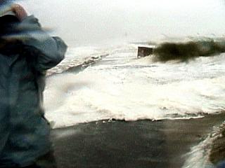
This picture shows Dave Cornwell and Jeff Gammons of the former "Weathervine" storm intercept team standing in near hurricane forced winds on the north side of Venice Inlet, Florida during the morning of September 14, 2001. Winds here were sustained near 70 MPH gusting to near 90! The view is to the west with the furious winds out of the NNW just as the calm center of the storm moved just to our NE. Note the appearance of the Gulf of Mexico as well as the storm surge water coming over the sand dunes. |
|
Dave Cornwell with the former "Weathervine" storm team stands in 70 MPH sustained winds with higher gusts on the north side of Venice Inlet, Florida during the early morning of September 14, 2001 as the center of the storm passes just to our northeast. The view here is to the west at the violent Gulf of Mexico. The smaller person taking Dave's picture is Jeff Gammons. Note the spray and foam being whipped up and over the sand dunes. |
|
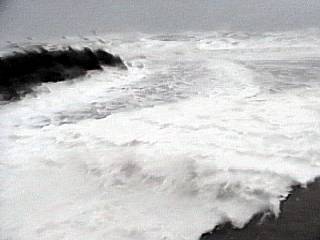
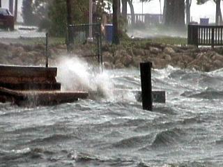
A wall of foaming water roars across the beach and spills over the sand dunes on the north side of venice Inlet, Florida on September 14, 2001. The winds here are NW at 70 MPH sustained with gusts much higher. The view is looking west towards the end of the inlet into the Gulf of Mexico. Dave Cornwell with the former "Weathervine" Storm Intercept Team is standing to the left covering his face from the stinging sand and spray. This surge is what causes 90 percent of tropical cyclone related deaths. Note the spray in the air as well as the "soapy" appearance of the extremely agitated seawater. This was under the eyewall of tropical storm Gabrielle. |
|
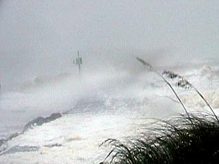
Sustained 70 MPH NW winds with higher gusts slam the north side of Venice Inlet, Florida during the morning of September 14, 2001. This scene was just minutes after the relative calm of the eye of tropical storm Gabrielle passed on to our NE. Some wind gusts approached 100 MPH with a pressure of 983 mb measured. Note the foamy water of the Gulf of Mexico coming over the sand dunes. The beach is completely under water. The reported wind were 70 MPH from the National Hurricane Center at 5 AM. This was at around 9 AM. I suspect that rapidly intensifying Gabrielle could have been a hurricane before reaching land without the NHC even knowing about it. The 2 AM advisory had only 50 MPH winds compared to the 70 MPH at 5 AM. What do you think this was at 8 or 9 AM? |
|
Here is another picture of the voilent motion of the storm surge on the north side of venice Inlet, Florida on September 14, 2001. The view is looking northwest towards the beach (underwater) to the north of the inlet into the Gulf of Mexico. Note the spray in the air as well as the "soapy" appearance of the extremely agitated seawater. Remember, most tropical cyclone deaths are from drowning / injuries caused by the storm surge, not the winds. This was under the eyewall of tropical storm Gabrielle. |
|
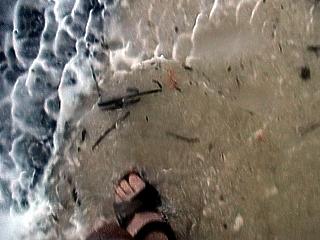
While observing storm surge and wind at Venice Inlet, Florida on the morning of September 14, 2001, I view my feet in ankle-deep salt water as it is whipped by the 70 MPH winds. I just wanted to show the "texture" and appearance of the water as it flooded things. Check out the white foam and "ruffles" in the surface of the water indicating its state of extreme agitation. |
|
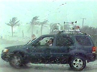
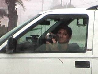
Here is a picture of myself in my 2001 Ford Escape SUV parked in 65 MPH+ winds at an angle so that my drivers side window can be rolled down to shoot video. This was near Venice, Florida on September 14, 2001. Note the portable weather station on top of the Ford Escape SUV. This became an important tool in recording wind, pressure, and rainfall in tropical storm Gabrielle's core. This picture is a still frame from Jeff Gammons with the former "Weathervine" chase team. |
|
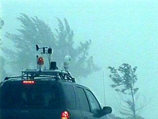
The "Weatherlab" portable weather station sits atop my 2001 Ford Escape SUV during penetration of the wind maxima of tropical storm Gabrielle on the morning of September 14, 2001 near Venice, Florida. This picture was taken by Jeff Gammons with the former "Weathervine" storm chase team also conducting the chase of tropical storm Gabrielle. Winds here are over 60 MPH. |
|
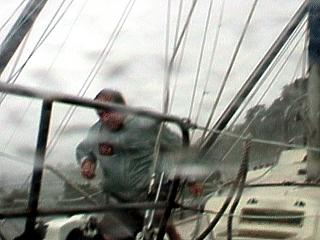
Jeff Gammons with the former "Weathervine" storm intercept team shoots video from the drivers side of the former "Weathervine" Chevy Blazer chase vehicle operated by Dave Cornwell. This is near Venice, Florida on September 14, 2001 and winds are near 70 MPH on the backside of tropical storm Gabrielle. Note the leaves (pine needles) on the drivers side of the Chevy SUV. |
|
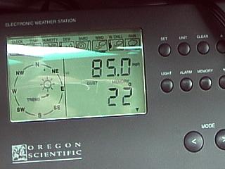
This picture shows the display for the roof mounted weather station. It is set for "Wind Memory" which records peak gusts over a period of a few minutes. The display shows "85.0 MPH" from a direction of "22 deg". The station wind direction assumnes the front of the car is pointed north but here we are facing due west towards the Gulf of Mexico meaning the wind is from about 257 degrees (from the Northwest). This measurement was made during the morning of September 14, 2001 north of Venice Inlet, Florida. |
|
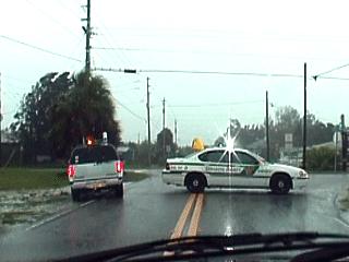
The Sarasota and Venice police did a great job at closing off roads to the barrier islands of the Florida west coast during the height of Gabrielle. We were allowed in and out of these areas "at our own risk". In this picture, police close the entrance road to Venice Inlet, which had 6 foot tides and 70 MPH+ winds at the time on September 14, 2001. |
|
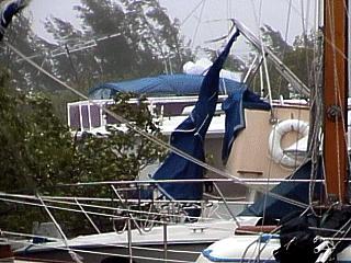
Boats at a marina near Casey Key, Florida take 60 MPH+ winds with little or no protection. Some boats get damaged or even sunk during tropical storm Gabrielle on September 14, 2001. Some damaged canvas flapping and busted poles can be seen in this picture. |
|
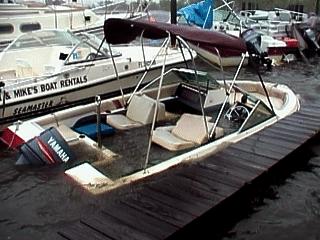
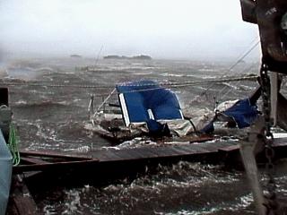
A run about type pleasure boat sinks at a marina in Casey Key, Florida during the morning of September 14, 2001. Winds here are over 60 MPH from the NW with higher gusts on the SW side of the core of tropical storm Gabrielle. Boats in this marina had no protection from the brute force of the winds, and many were damaged, sunk, or even destroyed. |
|
A line from a sailboat at a marina near Casey Key, Florida, lashes in 60 MPH+ winds during the morning of September 14, 2001. The line was whipping around like a whip and slashing everything it touched. This kind of element can be down right deadly to anyone in its path. |
|
An elusive and dangerous vortex called a "mini swirl" is caught on video as it moves across a small bay near a marina off Casey Key, Florida on September 14, 2001. These are small rotations, brief but violent, embedded in the eye wall of storms that intensify as they make landfall. Gabrielle was rapidly intensifying just as it made landfall near Venice Inlet and probably came ashore as a hurricane (unofficially). The mini swirl can be see here by the extra spray getting picked up off the water as it whirls in a counter-clockwise fashion. These are NOT tornadoes, just eddys and turbulence developing in the core wind field of a tropical system. Note the spray in the far background, left side, and right against the boats to the right. Note the center of the mini swirl where the water is darker due to the lighter winds relative to the surrounding areas. This feature was noted to rotate counter clockwise and was marked as a sudden wind gust as it came ashore. Imagine a rotation of only 25 MPH (relative to the mini swirl) with the feature moving along at 60 MPH. This will produce a gust to 85 MPH on one side of the swirl, while on the other, a 35 MPH lull in the prevailing 60 MPH winds! Dr Fujita discovered the mini swirl surveying damage from hurricane Andrew back in 1992. |
|
This is a view of the sky looking up from a marina near Casey Key, Florida during the morning of September 14, 2001. The sailboats to the lower right portion were eventually damaged or destroyed by tropical storm Gabrielle. The clouds in this picture were absolutely racing from left to right (view is NE). The small "funnel" type feature here could be seen rotating slightly as it raced from NW to SE with the prevailing 60 MPH-plus winds. Although rotating, it is not a tornadic storm, but an eddy or turbulence embedded in the low level winds of the storm. The scud clouds are in this "boundary layer" and also swirl and roll. Such vortices on the ground are called "mini swirls" and can cause destructive wind gusts. |
|
Voilent waves whisk across a small bay near Casey Key, Florida on September 14, 2001. This picture was taken off a dock of a marina that had many boats damaged or sunk. Winds are gusting over 60 MPH making the water look this way and filling the air with spray and foam. Note the "foggy" appearance of the air from the spray being kicked up. Tides here were also 4 to 5 feet above normal. |
|
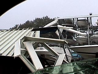
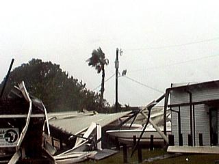
Major damage occurs to a boatyard and marina near Casey Key, Florida on the morning of September 14, 2001. Here, twisted metal and dangling sheets are all that remains from a boathouse roof. |
|
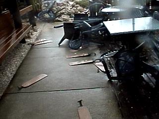
Major damage occurs to a seaside restaurant at a marina near Casey Key, Florida on September 14, 2001. Tables and chairs are overturned and the floor is littered with parts of the roof, ceiling, and most obviously, the fans once on the ceiling. Part of the roof was torn off this seafood eatery with a view right up at the fast moving scud through the gaping hole in the ceiling. Winds were still blowing 40 to 45 MPH through what was left of the restaurant making a very eerie sound. |
|
A desperate man struggles to save his sailboat from the wrath of Gabrielle's 65 MPH+ winds at the end of a marina near Casey Key, Florida during the morning of September 14, 2001. Note the two poles and lines overhead. These are from another boat that was being demolished and sunk by the beating of the winds and waves. The scene here shows the masts from the neighboring boat crashing down atop the sailboat. Proving no match for the power of a tropical cyclone, both boats wound up destroyed. Another housboat also sunk nearby, with a couple and their tiny dog escaping and swimming back to shore dazed with slight injuries. This is the kind of things that really show nature how "small" we really are. |
|
A sailboat is slammed into another at a marina in Casey Key, Florida during the morning of September 14, 2001. The boat quickly breaks apart and sinks sending its mast and riggings onto another boat to the right (note anchor). Winds here are over 60 MPH from the NW with higher gusts on the SW side of the core of tropical storm Gabrielle. |
|
Near Casey Key, Florida on September 14, 2001, yet another marina and its structures succomb to the effects of Gabrielle's winds. In the picture here, a structure loses it roof and sustains heavy damage. Winds here are gusting well over 60 MPH. |
|
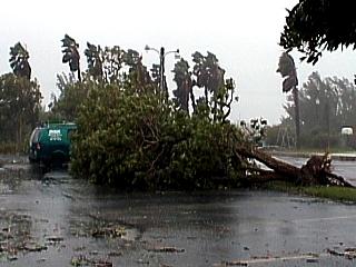
Trees are uprooted and cover a parking lot at a marina near Casey Key, Florida on the morning of September 14, 2001. Winds in this area gusted over 70 MPH as the storm center passed. Winds here are gusting over 60 MPH. I actually saw this one fall over! |
|
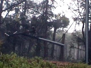
A powerline comes crashing down in Casey Key, Florida during the late morning of September 14, 2001. Winds here are sustained at about 50 MPH with gusts nearr 65 MPH. This was right along the Gulf shore while the backside of tropical storm Gabrielle was moving through. |
|
A piece of metal framework comes to rest in the street near Casey Key, Florida on September 14, 2001 during 60 MPH+ winds. The origin is unknown, probably part of a roof torn off or more likely a support for a canvas top on a yacht in a nearby marina. Note the standing water. |
|
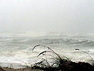
Fierce wind waves and storm surge batters the Gulf of Mexico shores of Casey Key, Florida on September 14, 2001. Winds here are up to 65 MPh with heavy rains and a "completely white" sea surface full of spray and foam. Note the poor visibility in the air due to the storm at sea. The beach here has been eroded all the way up to the road along the beachfront. |
|
A Hobie Cat type catamaran sailboat comes to rest along the side of Gulf Shore Drive in Casey Key, Florida during the morning of September 14, 2001. The beach is to the right and not visible. Winds here are 60 MPH+ with waves all the way up to the road. Note the sand across the roadway. The SUV is the former "Weathervine" Storm Intercept Team's Chevy Blazer. |
|
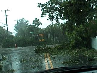
Tree debris covers part of the roadway to Casey Key, Florida during the morning of September 14, 2001. Winds here are gusting over 60 MPH and many trees and powerlines were felled by the storm. The storm center is actually moving away from this area at this time. |
|
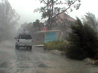
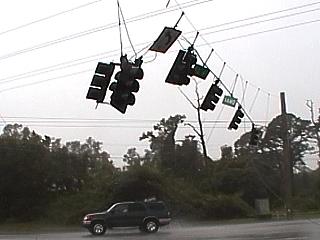
In Sarasota County, Florida along highway 41, traffic lights dangle and fall apart as tropical storm Gabrielle slams the area on September 14, 2001. Power outages and tree damage was very obvious with this storm. Winds here were over 50 MPH. |
|
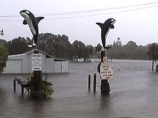
A waterway connecting the Gulf of Mexico backs up with a 6 foot above normal storm surge. A restaurant and marina are entirely covered by the flood as well as the parking lot in the foreground here. This was during the afternoon of September 14, 2001 near Sarasota County, Florida off highway 41. The two "whale" signs mark the plaza entrance. The sign on the right reads "additional parking". |
|
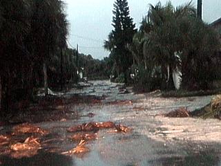
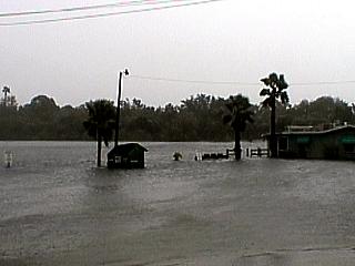
Fresh water covers the road and floods homes and businesses along it in Sarasota County, Florida on September 14, 2001. Tropical systems not only have wind, but often drop over 10 inches of rain causing flooding, even in areas that seldom see high water. Always carry reliable and up to date flood insurance! |
|
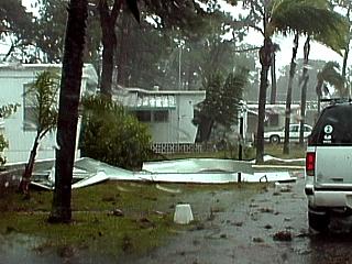
A trailer park in Sarasota County, Florida sustains damage from the winds in tropical storm Gabrielle on September 14, 2001. Metal debris and tree parts litter the road after the strong winds passed through this area. One metal piece actually flew through the air and hit the drivers side of my chase vehicle, and 2001 Ford escape causing minor damage. The Chevy SUV in front is the former "Weathervine" storm intercept team chase vehicle. |
|
A flying piece of aluminum slams into the driver's side of my 2001 Ford Escape SUV in a trailer park near Sarasota / Bradenton, Florida during noon on September 14, 2001. The trailer park was littered with debris, tree damage, and pieces of roofs. The strike of this flying metal was caught on camera and caused damage to the drivers side door of my new SUV - Arrrgh!! |
|
A restaurant, marina, and its parking lot are totally submerged by the rising salt waters of a river leading to the Sarasota bay and Gulf of Mexico near highway 41 in Sarasota County, Florida on September 14, 2001. The water edge on a normal day would be in the background by the trees. The building to the right is a seafood restaurant and the object in the center is a dumpster in the middle of a parking lot. Tides here are about 6 feet above normal and winds are over 50 MPH. |
|
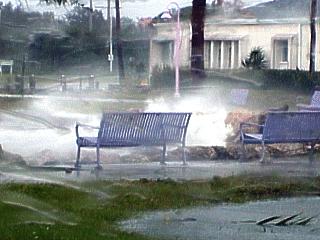
Large battering waves come over the seawall at the east waterfront of the bay near Sarasota / Bradenton, Florida during noontime on September 14, 2001. 60 MPH NW winds on the backside of tropical storm Gabrielle remained strong well behind the center and "core" wind field of the storm. |
|
Winds gusting near 60 MPH whip up large waves and spray in the bay near Sarasota / Bradenton, Florida during the afternoon of September 14, 2001. The waves in the bay were as high as 6 feet (that's high for a bay only a mile across)! Note the spray in the air reducing visibility in the strong NW winds. |
|
This picture shows the Sarasota municipal public boat ramp on the east side of the bay in Sarasota, Florida during the early afternoon of September 14, 2001. Tides here are about 5 feet higher than normal and waves up to 6 feet are battering the eastern water front of the bay. Winds are diminishing, but still gusting up to 60 MPH. The boat docks and ramp are "somewhere" under that rough water. |
| Tropical storm Gabrielle was over an increasingly favorable area for rapid tropical cyclone development just prior to landfall near Venice Inlet on the Florida West coast. There is a high debate on whether this system was actually a hurricane just as it was making landfall at around 8 AM on September 14, 2001. The intensification occurred because the storm was over the very warm waters of the Gulf of Mexico "loop current" and was becoming more "vertically stacked" (less sheared by a weak low pressure trough). Just before landfall, the central pressure of the system, as reported by a research aircraft was 997 mb at 2 AM EDT, 992 mb at 5 AM EDT, and a more impressive drop to 980 mb at 8 AM EDT (during landfall at Venice, FL). The 2 AM EDT advisory had maximum sustained winds at 50 MPH, but both the 5 and 8 AM EDT advisories had 70 MPH. Note that a MEASURED drop of 12 mb occurred in only 3 hours from 5 AM to 8 AM EDT - This is a drop of 4 mb per hour! Such rapid drops are said to be "rapid deepening" or even "explosive deepening" if more than 1 or 2 mb per hour. The small chart below shows the advisories on tropical storm Gabrielle before, during, and after landfall and at the time of interception by myself and the former "Weathervine" storm intercept team. Based on the wind and pressure readings, what do you think Gabrielle really was when it came ashore? |
| DATE | TIME | LAT | LON | WIND | CENTRAL PRESSURE | COMMENTS |
| 9-13 | 20:00 | 25.5N | 84.3W | 50 MPH | 998 mb / 29.47" | T.S. GABRIELLE |
| 9-13 | 23:00 | 25.5N | 84.0W | 50 MPH | 997 mb / 29.44" | -- |
| 9-14 | 02:00 | 25.7N | 84.6W | 50 MPH | 997 mb / 29.44" | -- |
| 9-14 | 05:00 | 26.1N | 83.1W | 70 MPH | 992 mb / 29.29" | MOVING NE |
| 9-14 | 08:00 | 27.2N | 82.5W | 70 MPH | 980 mb / 28.94" | LANDFALL |
| 9-14 | 11:00 | 27.6N | 82.2W | 60 MPH | 986 mb / 29.12" | INLAND |
| 9-14 | 14:00 | 28.0N | 81.8W | 50 MPH | 992 mb / 29.29" | INLAND |
HTML File "gabrie01.htm" - Developed By Chris Collura
To Return To The HOME Page Of This Site Click The "INDEX.HTM" Link Here!