
| This area shows pictures taken from the observations of the effects of hurricane Floyd on September 15, 1999 as the storm came within 150 miles of the Florida East Coast. This storm began as a strong wave off Africa that moved north of the wind ward islands while strengthening to a hurricane. The storm continued west, then recurved to the north, slamming the Bahamas and barely missing Floridas East coast. The storm eventually reached strong category 4 strength, with 155 MPH sustained winds near the Bahamas. Landfall occurred in North Carolina as a category 3 storm. Hurricane Floyd caused the biggest evacuation from a tropical system in history and was very powerful with 155 MPH sustained winds. Although the storm was not directly intercepted, some pictures of its effects can be found in this area. |
|
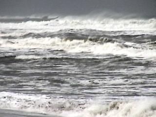
This is Boynton Beach, Florida on September 15, 1999 showing the ocean state as Hurricane Floyd was ravaging the Bahamas 150 miles to the east with 155 MPH winds. Winds here are moderate to strong from the North while waves are over 10 feet. Note the confused ocean state and darkening grey sky looking to the NE. Tides here are at least 3 feet above normal. Shortly after taking this picture, I was politely requested to leave by police officials, after all, this was an evacuation area. |
|
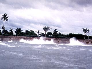
On September 15, 1999 in West Palm Beach, Florida, waves smash into the sea wall just south of Lake Worth Inlet. This picture was taken from a Sea Doo watercraft about 100 yards offshore. Tides 3 to 4 feet above normal and 5 to 10 foot breakers from swell waves, radiating outward from Hurricane Floyd 150 Miles to the east, cover the beach and smash into the sea wall. |
|
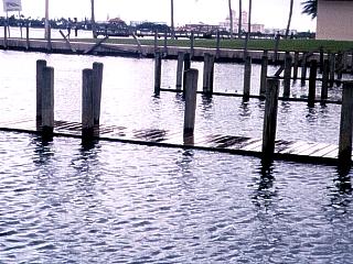
During the passage of super-hurricane Floyd on September 15, 1999, tides nearly four feet above normal cover docks in the bay in West Palm Beach, Florida. Winds here are moderate from the north as the hurricane passes 100 to 150 miles to the east of the area. As the storm moved to the NW, then turned to the north (missing Florida), the "dome" of water associated with the leading edge of the storm affected the coastal areas of Florida. This is because the "dome" of water in such a large storm may actually extend beyond the wind-core of the hurricane forced winds and cause coastal flooding even away from the damaging winds. Floyd was less than 150 miles to the east with 155 MPH winds at the time this picture was taken. |
HTML File "floyd99.htm" - Developed By Chris Collura
To Return To The HOME Page Of This Site Click The "INDEX.HTM" Link Here!