
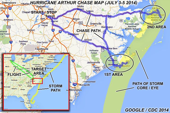
| This area shows the interception of hurricane "Arthur" in early July of 2014, with the interception lasting from the late evening of July 3 near Morehead City in North Carolina and overnight until early morning on the 4th into the outer banks region near Nags Head. Arthur was the first named storm of the 2014 Atlantic hurricane season and struck North Carolina with winds of 100 MPH, making it a category 2 hurricane on the Saffir-Simpson scale. The storm originated from a trough of low pressure east of Florida during the last week in June. The system became a low pressure area, acquiring tropical characteristics, then a tropical depression. By July 1-2, tropical storm Arthur formed and steadily strengthened into a hurricane late on July 2. The storm was very slow moving, but began drifting north on July 2, taking aim at eastern North Carolina. The storm strengthened and organized steadily, becoming a category 2 storm with 100 MPH winds late on July 3, and made landfall just east of Morehead City / Cape Lookout before Midnight on July 3. The storm continued to the NE, and accelerating, and crossed the Pamlico Sound during the early morning of July 4. The eye then went directly over the outer banks, roughly 5 miles or so south of Nags Head, before going back out to sea just before sunrise on July 4. The storm continued to the NE, weakening over cooler waters on July 5, and made a second landfall near Nova Scotia, Canada. The storm quickly became extratropical after that, with its remnants continuing to the NE over the Canadian Maritimes. My interception and observations of hurricane Arthur are shown in detail in this chase log. Note - This page may take a while to load on some SLOWER connections! |
| CHASER NAME | HOME CITY | CALLSIGN | OCCUPATION |
| CHRIS COLLURA | SUNRISE, FL | KG4PJN | COMPUTER ANALYST |
The list above shows personnel who actively participated in this chase, including myself. I was currently on a long-term computer project in Chicago at this time, so to chase this storm I flew into Raleigh, North Carolina on July 3 to make the target areas (either Morehead City or the outer banks) by that same evening. I wrapped up the intercept during the morning of July 4 near Nags Head and headed back to Raleigh, NC for the night. I flew back to Chicago on the morning of July 5.
|
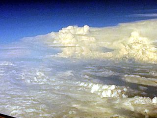
Flying into Raleigh, NC from Chicago late in the day on July 3, 2014. This is the "edge" of the cloud shield and feeder bands of hurricane Arthur looming over the horizon. |
|
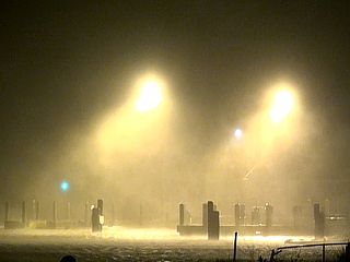
Sparks fly as powerlines touch in strong winds near Atlantic Beach / Morehead City, NC late on July 3, 2014. |
|
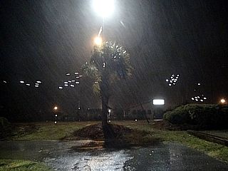
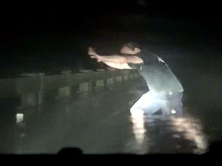
Here is a picture of myself on the Highway 64 causeway leading across a portion of the Pamlico Sound just before entering the eye for the second time during the early morning of July 4th. Winds are gusting to nearly 100 MPH here. |
|
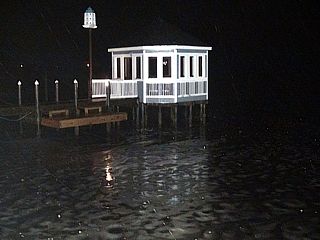
Negative surge (offshore flow pushes water in portion of bay OUT) with no water under docks and such. This was before dawn near Nags Head on July 4. |
|
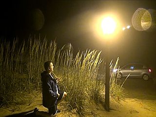
Some chasers from Virginia inside the eerie calm of the eye of hurricane Arthur near Nags Head, NC early on July 4th (4 AM). Note the thin fog in the air. Stars visible aloft at the time. |
|
Backside of the eye and start of second eyewall with strong winds at US Coast Guard station in the outer banks (NC). Early july 4, 2014. |
|
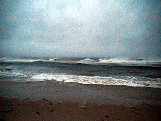
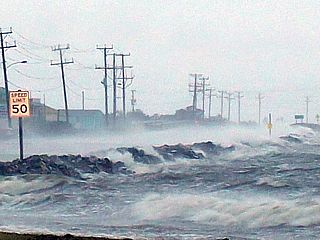
Hurricane surf off the outer banks NC as hurricane Arthur moves offshore and races to the NE during the morning of July 4. |
|
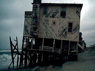
Collapsing beachfront home on eroding shoreline on the outer banks in NC during hurricane Arthur early on July 4, 2014. |
|
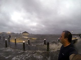
Self picture of myself watching the rapidly rising water (Pamlico Sound) near Nags Head, NC at daybreak on July 4. |
|
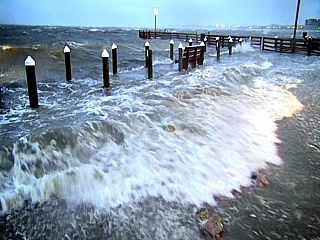
Storm surge and waves lash a waterfront area off Highway 64 near Nags Head, NC during the morning of July4 as the Pamlico Sound surge ensued after passage of the eye of the storm. |
|
Same place (showing the negative surge) later during the morning on July 4 near Nags Head, NC. This water rushed back in fast with the wind shift to NW as the storm eye passed. |
|
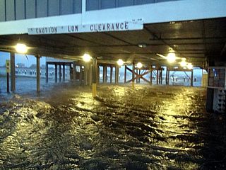
Flooded parking area near Nags Head, NC during the morning of July4 as the Pamlico Sound surge started. |
|
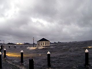
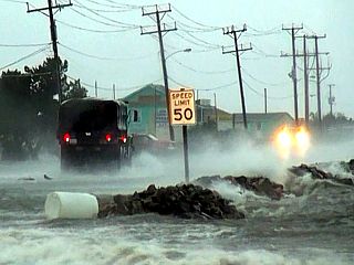
Highway 64 flooding from the Pamlico Sound storm surge early on July 4, 2014 near Nags Head, NC. |
|
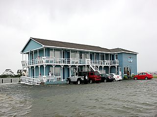
Flooded residence from the rapidly rising water (Pamlico Sound) near Nags Head, NC after daybreak on July 4. |
|
US Army reserve vehicle transporting pregnant woman to safety as she was in labor during the storm. This is Highway 64 flooding from the Pamlico Sound storm surge early on July 4, 2014 near Nags Head, NC. |
|
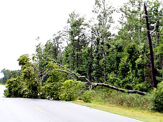
One of many downed trees along Highway 64 east of the Pamlico Sound later on during the morning of July 4th. Damage from this storm was mainly confined to the exposed areas and parts of the outer banks. |
|
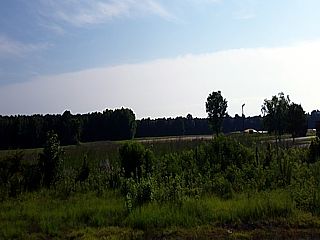
The "edge" of hurricane Arthur (cirrus shield) moving away and being replaced with beautiful July 4th weather over eastern NC. |

|
View looking east from over the Great Lakes enroute to Chicago from Raleigh, NC early on the morning of July 5th. The distant deck of high clouds is the edge of Arthur as it was becoming extratropical over Canada and the extreme NE USA. |
HTML File "arthur14.htm" - Developed By Chris Collura
To Return To The HOME Page Of This Site Click The "INDEX.HTM" Link Here!